Turnagain Pass Avalanche Forecast
|
![]() ![]() |
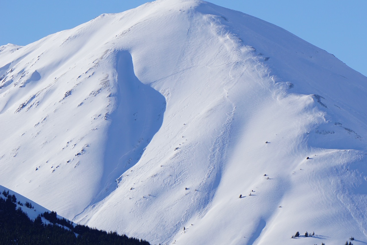
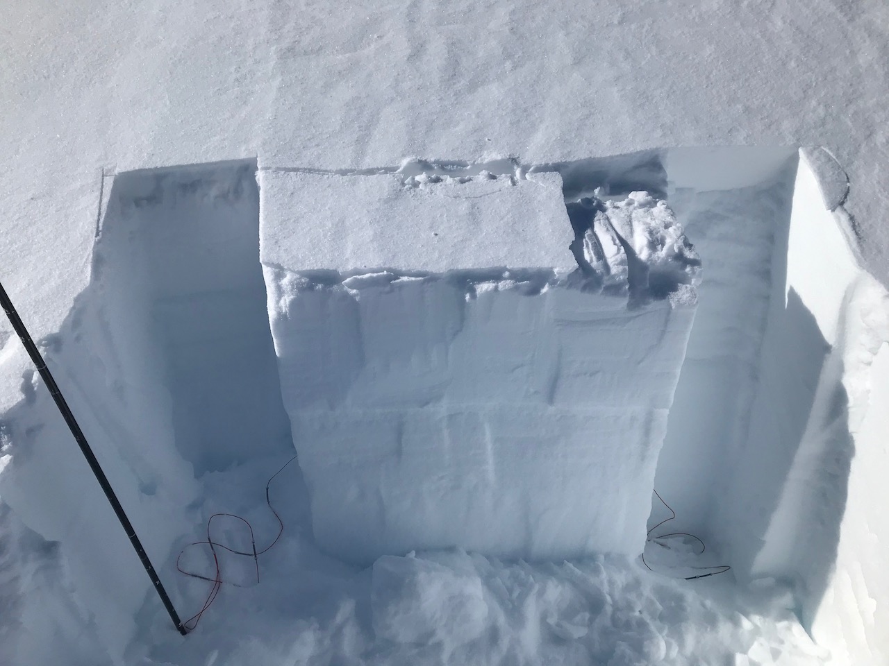
The avalanche danger is MODERATE above 1000′. Triggering slab avalanche is possible in the top 3′ of the snowpack. Recently wind loaded slopes are the most suspect. Watch for stiff, drifted snow and cracking. Remember triggering a shallow avalanche could step down to older layers of buried weak snow. Assess the snowpack as you travel, identify areas of concern and evaluate terrain consequences. Give cornices a wide berth and watch your sluff if you find soft snow on steep slope.
Below 1000′ the avalanche danger is LOW. There is a hard melt-freeze crust at the surface and triggering an avalanche is unlikely. As always, watch for changing conditions.
SUMMIT LAKE/SNUG HARBOR/LOST LAKE/SEWARD: These areas have been hit hardest by the recent NW winds, making avalanche conditions especially sensitive. Use extra caution if you are getting out in any of these zones.
Signal Word | Size (D scale) | Simple Descriptor |
Small | 1 | Unlikely to bury a person |
Large | 2 | Can bury a person |
Very Large | 3 | Can destroy a house |
Historic | 4 & 5 | Can destroy part or all of a village |
The winds are forecast to be mostly light today. However, the winds over the past couple days moved a lot of snow around, impacting surface conditions and creating stiff slabs at upper and mid elevations. There were a number of natural wind slab avalanches observed on Monday as well as a few human triggered ones, including a snowmachine triggered slide on the Seattle Creek Headwall. Today these slabs will likely be less tender and prone to triggering but a caution on steep wind loaded slopes is still advised, especially immediately below ridgelines, in cross-loaded gullies, and below convexities. On some aspects these slabs formed over weak snow (more in Problem 2) and/or on a crust. Due to this structure it possible that a person could make it out into the middle of a slope before triggering an avalanche, or for multiple skiers or riders to put tracks on a slope before somebody triggers an avalanche. Avoid areas that look pillowed and watch for cracks shooting out from your snowmachine or skis, and ‘punchy’ feeling stiff snow over softer snow. Cornices may be sensitive today and triggering a cornice fall could trigger an avalanche on the slope below.
Loose snow avalanches: Steep north facing slopes that are sheltered from the wind have loose snow sitting on top of firm surfaces. Triggering dry loose avalanches (sluffs) in that terrain is possible today.
Natural wind slab avalanche on Tri-Tip peak in Summit Lake that likely occurred Monday afternoon or evening. Photo taken yesterday, 4.6.21.
Signal Word | Size (D scale) | Simple Descriptor |
Small | 1 | Unlikely to bury a person |
Large | 2 | Can bury a person |
Very Large | 3 | Can destroy a house |
Historic | 4 & 5 | Can destroy part or all of a village |
As mentioned in a number of recent forecasts, we seem to be stuck in a pattern of clear and sunny weather where weak surface snow forms and then it snows a little, and then the wind blows. Each time this happens we end up with another buried weak layer covered by a wind slab. Due to the weak snow (facets and/or surface hoar) it’s hard for the slab to bond to the snow below and we develop a persistent slab issue. With this happening over and over we have a variety of weak layers in the upper 3′ of the snowpack. Today is an ‘on the fence’ definition day. If you trigger an avalanche it could be a wind slab or persistent slab. Or triggering a shallow wind slab could step down to an older weak layer and trigger a larger avalanche. Some of the recent avalanches likely failed on buried weak layers. The bottom line is that steep slopes with wind affected snow should be approached with caution and the consequences of a slope sliding, and where the snow would go should always be considered.
Yesterday: Skies were clear with high temperatures in the low teens at upper elevations and high 20°Fs in the valleys. Winds were northwesterly 5-10 mph with gusts into the teens. Overnight skies remained clear with low temperatures in the single digits to mid teens. Winds were light and westerly.
Today: Increasing clouds with light west winds and temperatures in the teens to high 20°Fs. Snow showers starting this evening and continuing into tomorrow. Overnight temperatures will be in the 20°Fs and winds will be from the southeast 15-25 mph with gusts into the 30s.
Tomorrow: Cloudy with snow showers tapering off in the afternoon. Temperatures will be in the 20°Fs and winds shift to the northwest in the early morning starting out 5-10 mph and increasing to 20-30 mph in the afternoon. Gradual clearing expected overnight with dropping temperatures and strong NW winds forecast to continue into Friday.
PRECIPITATION 24-hour data (6am – 6am)
Temp Avg (F) | Snow (in) | Water (in) | Snow Depth (in) | |
---|---|---|---|---|
Center Ridge (1880′) | 14 | 0 | 0 | 109 |
Summit Lake (1400′) | 12 | 0 | 0 | 47 |
Alyeska Mid (1700′) | 13 | 0 | 0 | 119 |
RIDGETOP 24-hour data (6am – 6am)
Temp Avg (F) | Wind Dir | Wind Avg (mph) | Wind Gust (mph) | |
---|---|---|---|---|
Sunburst (3812′) | 8 | W | 7 | 18 |
Seattle Ridge (2400′) | 16 | W | 2 | 9 |
Date | Region | Location | Observer |
---|---|---|---|
05/22/23 | Turnagain | Avalanche: Tincan | Nick D'Alessio |
05/12/23 | Turnagain | Avalanche: Tincan, Sunburst, Magnum, Cornbiscuit | Heather Thamm |
05/07/23 | Turnagain | Observation: Tincan – Bear Tracks | CNFAIC Staff |
05/05/23 | Turnagain | Observation: Seattle Ridge | AS/ WW Forecaster |
05/02/23 | Turnagain | Observation: Cornbiscuit | Schauer/ Sturgess Forecaster |
05/02/23 | Turnagain | Observation: Seward Hwy Turnagain Pass | Joel Curtis |
04/30/23 | Turnagain | Observation: Magnum | Ayla, Kit Crosby, Barton |
04/29/23 | Turnagain | Observation: Tincan | John Sykes |
04/28/23 | Turnagain | Avalanche: Taylor Pass/Pastoral | Schauer/ Creighton Forecaster |
04/28/23 | Turnagain | Avalanche: Tincan | Andy Moderow |
Status of riding areas across the Chugach NF is managed by the Glacier and Seward Ranger Districts, not avalanche center staff. Riding area information is posted as a public service to our users and updated based on snow depth and snow density to prevent resource damage at trailhead locations. Riding area questions contact: mailroom_r10_chugach@fs.fed.us
Area | Status | Weather & Riding Conditions |
---|---|---|
Glacier District |
Subscribe to Turnagain Pass
Avalanche Forecast by Email
This is a general backcountry avalanche advisory issued for Turnagain Arm with Turnagain Pass as the core advisory area. This advisory does not apply to highways, railroads or operating ski areas.