Turnagain Pass RSS

Archives
ARCHIVED - Forecasts expire after 24 hours.
Issued
Thu, March 31st, 2022 - 7:00AM
Expires
Fri, April 1st, 2022 - 7:00AM
Forecaster
John Sykes
Avalanche risk The Bottom Line

The avalanche danger is CONSIDERABLE above 2500′. Moderate east winds are building fresh wind slabs up to a foot deep at upper elevations that are likely to be triggered by a person and possible for natural avalanches. The potential to trigger a very large avalanche on a deeper weak layer also exists, with multiple layers of buried surface hoar 3-6′ deep in the snowpack. Conservative terrain selection and decision-making is recommended.

The avalanche danger is MODERATE  between 1000 – 2500′. Wind slabs may be found in isolated locations, and the concern of deeper avalanches exists down to about 1500′ where a stout melt freeze crust starts. Below 1000′ the avalanche danger is LOW. 

SUMMIT LAKE/LOST LAKE/SNUG HARBOR: Winds are forecast to increase across the area today ahead of a storm that should bring light snowfall starting tonight. Elevated avalanche danger due to wind loading exists across the region. The potential for deeper avalanches on buried weak layers is also possible, especially in interior areas with shallower overall snowpack depths.

Thu, March 31st, 2022
Alpine
Above 2,500'
3 - Considerable
Avalanche risk
Treeline
1,000'-2,500'
2 - Moderate
Avalanche risk
Below Treeline
Below 1,000'
1 - Low
Avalanche risk
0 - No Rating
1 - Low
2 - Moderate
3 - Considerable
4 - High
5 - Extreme
Avalanche risk Avalanche risk Avalanche risk Avalanche risk Avalanche risk
Travel Advice Generally safe avalanche conditions. Watch for unstable snow on isolated terrain features. Heightened avalanche conditions on specific terrain features. Evaluate snow and terrain carefully; identify features of concern. Dangerous avalanche conditions. Careful snowpack evaluation, cautious route-finding, and conservative decision-making essential. Very dangerous avalanche conditions. Travel in avalanche terrain not recommended. Extraordinarily dangerous avalanche conditions. Avoid all avalanche terrain.
Likelihood of Avalanches Natural and human-triggered avalanches unlikely. Natural avalanches unlikely; human-triggered avalanches possible. Natural avalanches possible; human-triggered avalanches likely. Natural avalanches likely; human-triggered avalanches very likely. Natural and human-triggered avalanches certain.
Avalanche Size and Distribution Small avalanches in isolated areas or extreme terrain. Small avalanches in specific areas; or large avalanches in isolated areas. Small avalanches in many areas; or large avalanches in specific areas; or very large avalanches in isolated areas. Large avalanches in many areas; or very large avalanches in specific areas. Very large avalanches in many areas.
Recent Avalanches
  • Magnum – A large cornice fall in PMS bowl at 3400′ on the SW aspect of Magnum triggered a large avalanche on the slope below. Luckily, as far as we know, no one was travelling in the area and caught in the avalanche. You can see the gouge marks left by the cornice in the bed surface below, this is a very large trigger that appears to have released an avalanche on one of our deeper weak layers.

Cornice fall triggering a large slab avalanche that ran to the valley bottom on PMS bowl on Magnum. Photo Kellie Okonek 3.30.22

  • Seattle Ridge – A glide crack released just south of the moto uptrack yesterday sometime while we were riding up on Seattle Ridge. This glide release was relatively small, but it still created a large debris pile and released down to the ground.

Glide avalanche on SE aspect at about 2000′ that released during the day yesterday. Photo 3.30.22

  • Wet loose – Lots of wet loose avalanches on east, south, and west aspects yesterday, including some from within the past two days that triggered a slab avalanche on their way down (see ob here).

Wet loose avalanches on S face of Wolverine with a few larger debris piles that likely caused a slab avalanche to release on their way down. Photo 3.30.22

Avalanche Problem 1
  • Wind Slabs
    Wind Slabs
  • Certain
    Very Likely
    Likely
    Possible
    Unlikely
    Likelihood
  • Historic (D4-5)
    Very Large (D3)
    Large (D2)
    Small (D1)
    Size
Wind Slabs
Wind Slab avalanches are the release of a cohesive layer of snow (a slab) formed by the wind. Wind typically transports snow from the upwind sides of terrain features and deposits snow on the downwind side. Wind slabs are often smooth and rounded and sometimes sound hollow, and can range from soft to hard. Wind slabs that form over a persistent weak layer (surface hoar, depth hoar, or near-surface facets) may be termed Persistent Slabs or may develop into Persistent Slabs.

Likelihood of Avalanches
Terms such as "unlikely", "likely", and "certain" are used to define the scale, with the chance of triggering or observing avalanches increasing as we move up the scale. For our purposes, "Unlikely" means that few avalanches could be triggered in avalanche terrain and natural avalanches are not expected. "Certain" means that humans will be able to trigger avalanches on many slopes, and natural avalanches are expected.

Size of Avalanches
Avalanche size is defined by the largest potential avalanche, or expected range of sizes related to the problem in question. Assigned size is a qualitative estimate based on the destructive classification system and requires specialists to estimate the harm avalanches may cause to hypothetical objects located in the avalanche track (AAA 2016, CAA 2014). Under this schema, "Small" avalanches are not large enough to bury humans and are relatively harmless unless they carry people over cliffs or through trees or rocks. Moving up the scale, avalanches become "Large" enough to bury, injure, or kill people. "Very Large" avalanches may bury or destroy vehicles or houses, and "Historic" avalanches are massive events capable of altering the landscape.

Signal Word Size (D scale) Simple Descriptor
Small 1 Unlikely to bury a person
Large 2 Can bury a person
Very Large 3 Can destroy a house
Historic 4 & 5 Can destroy part or all of a village
More info at Avalanche.org

After a beautiful and clear day in the mountains yesterday we are transitioning back to stormier weather today, with snow showers possible and increasing wind. The wind is coming ahead of the precipitation for this storm which could be exactly what we need to help knock down a new layer of surface hoar that formed on top of a thin melt freeze crust above 1500′ in Turnagain Pass. Wind speeds are expected to be 15-30 mph today with gusts possible up to 50 mph. We observed that thin, breakable melt freeze crust on all aspects up to our high point at 3000′ yesterday which should limit the amount of snow available for transport. Somehow the wind always seems to find snow to move around, so wind slabs up to a foot deep are still the most likely avalanche to trigger today. Human triggered wind slabs are likely and natural triggered wind slabs are possible.

Wind slabs are most likely to be found at upper elevations along ridgelines, cross loaded gullies, and convex rolls. Keep an eye out for shooting cracks or hollow feeling pillows of snow to identify areas with fresh wind slabs. With a new layer of buried surface hoar and facets potentially underneath these wind slabs they could be easier to trigger than normal, release on lower angle slopes, and propagate widely. The bigger concern from a risk management perspective is the potential for triggering a very large avalanche on a deeply buried persistent weak layer, see problem 2 for that discussion.

Cornice: The recent cornice fall in PMS bowl on Magnum is a good reminder of the hazard that cornices can pose, especially on days where they are getting intense solar heating. Today might not have a ton of sunshine, but with moderate winds cornices will be building again and could release more easily where new snow has been added.

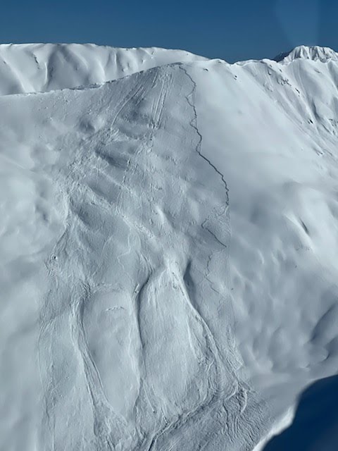
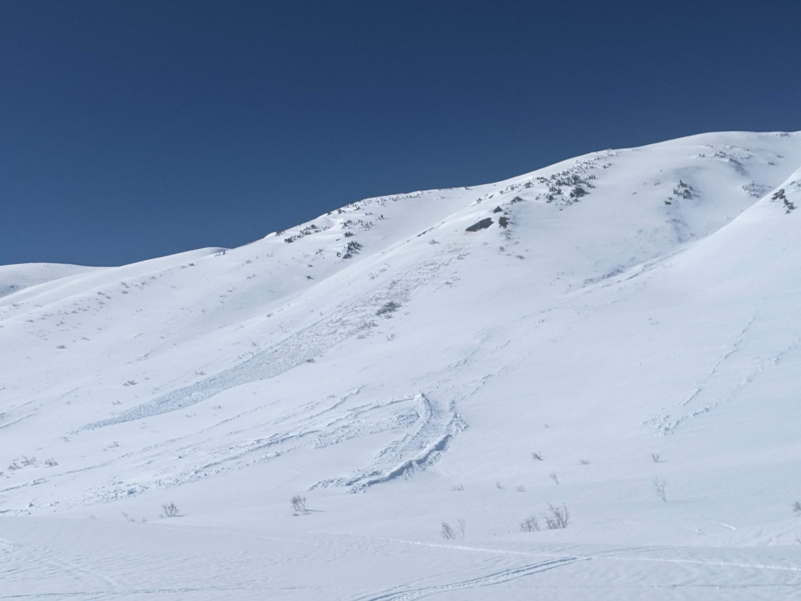
Glide: A glide avalanche released along Seattle Ridge yesterday, just south of the moto up track. We have received many observations of glide cracks opening up across the area and they are becoming more active as we move towards the spring. Try to avoid spending time underneath glides as they can release without warning and create large destructive avalanches.

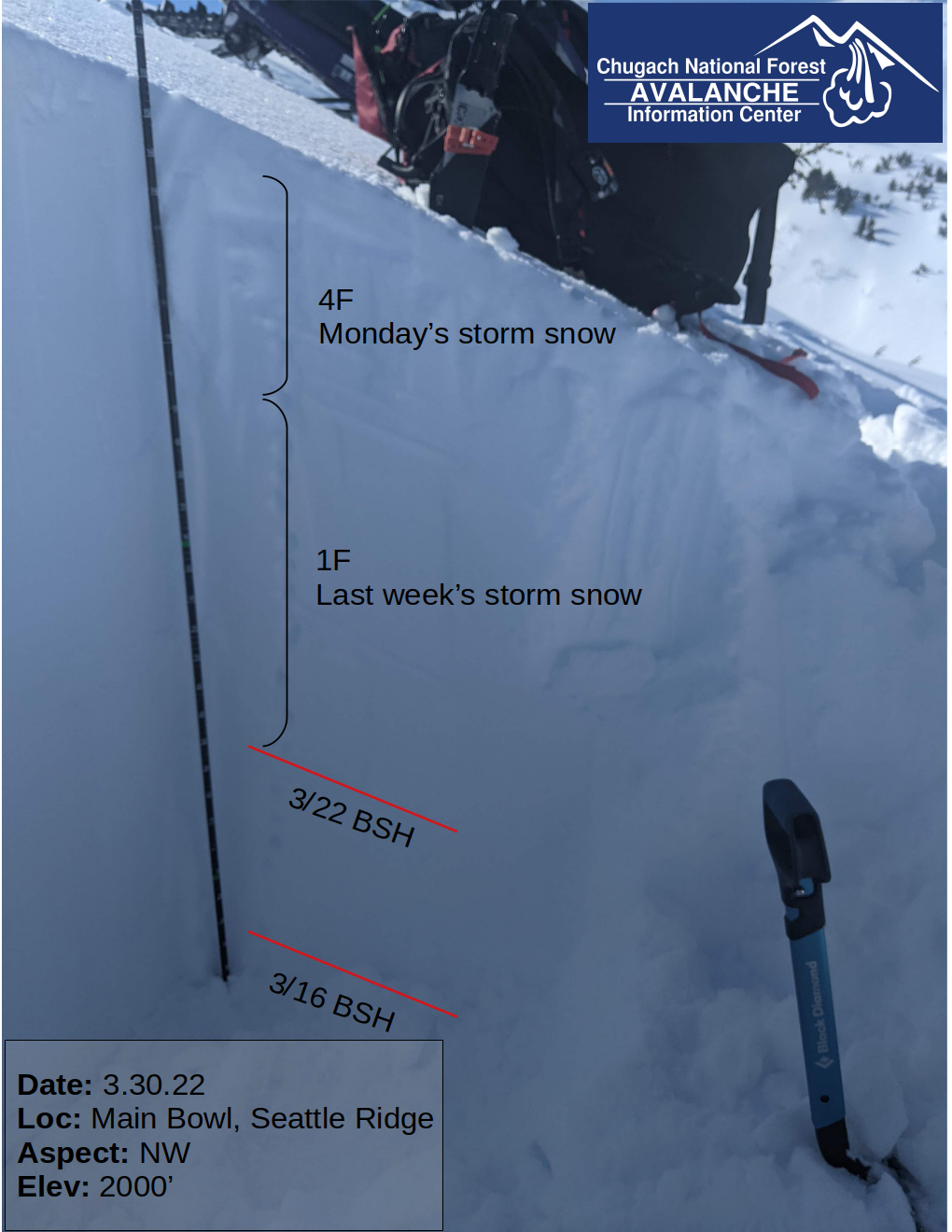
New batch of surface hoar and surface facets above a thin, breakable melt freeze crust which we observed from roughly 1500′ up to our high point of 3000′. Photo 3.30.22

Avalanche Problem 2
  • Deep Persistent Slabs
    Deep Persistent Slabs
  • Certain
    Very Likely
    Likely
    Possible
    Unlikely
    Likelihood
  • Historic (D4-5)
    Very Large (D3)
    Large (D2)
    Small (D1)
    Size
Deep Persistent Slabs
Deep Persistent Slab avalanches are the release of a thick cohesive layer of hard snow (a slab), when the bond breaks between the slab and an underlying persistent weak layer deep in the snowpack. The most common persistent weak layers involved in deep, persistent slabs are depth hoar or facets surrounding a deeply buried crust. Deep Persistent Slabs are typically hard to trigger, are very destructive and dangerous due to the large mass of snow involved, and can persist for months once developed. They are often triggered from areas where the snow is shallow and weak, and are particularly difficult to forecast for and manage.

Likelihood of Avalanches
Terms such as "unlikely", "likely", and "certain" are used to define the scale, with the chance of triggering or observing avalanches increasing as we move up the scale. For our purposes, "Unlikely" means that few avalanches could be triggered in avalanche terrain and natural avalanches are not expected. "Certain" means that humans will be able to trigger avalanches on many slopes, and natural avalanches are expected.

Size of Avalanches
Avalanche size is defined by the largest potential avalanche, or expected range of sizes related to the problem in question. Assigned size is a qualitative estimate based on the destructive classification system and requires specialists to estimate the harm avalanches may cause to hypothetical objects located in the avalanche track (AAA 2016, CAA 2014). Under this schema, "Small" avalanches are not large enough to bury humans and are relatively harmless unless they carry people over cliffs or through trees or rocks. Moving up the scale, avalanches become "Large" enough to bury, injure, or kill people. "Very Large" avalanches may bury or destroy vehicles or houses, and "Historic" avalanches are massive events capable of altering the landscape.

Signal Word Size (D scale) Simple Descriptor
Small 1 Unlikely to bury a person
Large 2 Can bury a person
Very Large 3 Can destroy a house
Historic 4 & 5 Can destroy part or all of a village
More info at Avalanche.org

It is still possible to trigger a very large and destructive avalanche on a deeper weak layer. However, with the weak layers buried 3-6′ deep in Turnagain Pass underneath very strong and supportable snow from the past two storms the chances of finding the trigger location are getting lower. In our snowpit yesterday at 2000′ on a north aspect in main bowl off Seattle Ridge we were able to find the 3/22 and 3/16 buried surface hoar layers within the top 5′ of the snowpack. They did not show any signs of instability in our tests, but we don’t really expect them to now that they are buried so deeply. This is the trickiest part about deep persistent slabs, they tend to show no signs of instability until a trigger hits the sweet spot and they create a huge avalanche.

Unfortunately, that means we are stuck grappling with the question of how much are we willing to expose ourselves to this low likelihood but high consequence hazard. If you decide to venture into steep terrain make sure to follow safe travel protocols: only expose 1 person in avalanche terrain at a time, stop and group up in safe zones outside the runout, always spot your partners. Avoiding this issue is pretty simple, just stick to terrain less than 30 degrees and be aware of overhead hazards because there is the potential for remote triggering. Personally, after triggering two avalanches on the 3/16 buried surface hoar last week on Pete’s North, I am going to keep it conservative for awhile longer and let the snowpack have some extra time to bury those layers even deeper.

Snowpack structure from our pit in Main Bowl. Overall the upper snowpack is strong, but those buried persistent weak layers make for very concerning structure 3-6′ down. Photo 3.30.22

Weather
Thu, March 31st, 2022

Yesterday: Clear and calm winds during the day with temperatures in the mid 20s to mid 30s. Wind speed increased overnight with averages of 10-15 mph starting around 9 pm and gusts up to 30 mph.

Today: Chance of snow showers with up to an inch of accumulation possible in Turnagain Pass and Girdwood. Up to 4″ of snow possible for Portage and Placer, with snow line at about 400′. Winds will bump up again early this morning and then be steady with averages of 15-30 mph and gusts up to 50 mph possible at ridgelines throughout the day. Temperatures should remain consistent in the mid 20s to mid 30s.

Tomorrow: A storm system is moving into the area tonight and tomorrow, with 3-5″ of snow expected for Turnagain Pass and Girdwood through Friday evening. Portage and Placer could see 12-18″ of new snow by the end of the day on Friday. Temperatures and snow line are forecast to stay relatively consistent through Friday. Winds are also expected to stay elevated throughout the storm, with the strongest winds impacting the area in the early morning on Friday.

PRECIPITATION 24-hour data (6am – 6am)

Temp Avg (F) Snow (in) Water (in) Snow Depth (in)
Center Ridge (1880′) 34 0 0 116
Summit Lake (1400′) 31 0 0 41
Alyeska Mid (1700′) 37 0 0 NA

RIDGETOP 24-hour data (6am – 6am)

Temp Avg (F) Wind Dir Wind Avg (mph) Wind Gust (mph)
Sunburst (3812′) 26 ENE 12 32
Seattle Ridge (2400′) 26 SE 10 30
Observations
Recent Observations for Turnagain Pass
Date Region Location
04/23/24 Turnagain Observation: Turnagain Sunny Side
04/21/24 Turnagain Observation: Bertha Creek
04/20/24 Turnagain Avalanche: Spokane Creek
04/16/24 Turnagain Observation: Cornbiscuit
04/15/24 Turnagain Observation: Taylor Pass
04/15/24 Turnagain Observation: Seward Highway – Tern Lake to Portage
04/14/24 Turnagain Observation: Sunburst
04/14/24 Turnagain Observation: Turnagain Pass Snomo
04/13/24 Turnagain Observation: Spokane Creek
04/11/24 Turnagain Observation: Tincan
Riding Areas

The riding areas page has moved. Please click here & update your bookmarks.


Subscribe to Turnagain Pass
Avalanche Forecast by Email

This is a general backcountry avalanche advisory issued for Turnagain Arm with Turnagain Pass as the core advisory area. This advisory does not apply to highways, railroads or operating ski areas.