Turnagain Pass
|
![]() ![]() |
The avalanche danger is LOW below 3,000′ this morning and will rise to CONSIDERABLE this afternoon/evening with the heat of the day. Once surface crusts soften and become unsupportable, human triggered wet loose avalanches will be likely on steep sunny slopes. These could be large and dangerous in big terrain and could initiate a wet slab avalanche, creating a much larger slide. Cornice falls are also likely late in the day and glide avalanches possible at anytime. Above 3,000′ where the snow is drier, a MODERATE danger exists for triggering a deep slab avalanche on all aspects.
PORTAGE VALLEY: Summer trails with avalanche terrain overhead, like Byron Glacier Trail and Crow Pass, are not recommended in the afternoon or evening due to the possibility of an avalanche occurring above.
SUMMIT LAKE (& INTERIOR EASTERN KENAI MTS): Human triggered slab avalanches remain possible in upper elevation terrain on all aspects. This area has a thin snowpack with many weak layers. High elevation sun-baked slopes are the most suspect for triggering a slab.
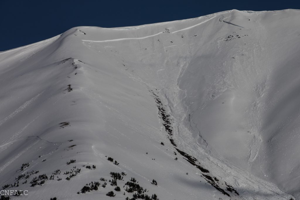
SEWARD/LOST LAKE: The snowpack is warming up and dangerous avalanche conditions are occurring late in the day in this area as well. A large avalanche released on Mt. Marathon Thursday. These types of avalanches remain possible.
![]() |
![]() |
![]() |
![]() |
![]() |
|
Travel Advice | Generally safe avalanche conditions. Watch for unstable snow on isolated terrain features. | Heightened avalanche conditions on specific terrain features. Evaluate snow and terrain carefully; identify features of concern. | Dangerous avalanche conditions. Careful snowpack evaluation, cautious route-finding, and conservative decision-making essential. | Very dangerous avalanche conditions. Travel in avalanche terrain not recommended. | Extraordinarily dangerous avalanche conditions. Avoid all avalanche terrain. |
Likelihood of Avalanches | Natural and human-triggered avalanches unlikely. | Natural avalanches unlikely; human-triggered avalanches possible. | Natural avalanches possible; human-triggered avalanches likely. | Natural avalanches likely; human-triggered avalanches very likely. | Natural and human-triggered avalanches certain. |
Avalanche Size and Distribution | Small avalanches in isolated areas or extreme terrain. | Small avalanches in specific areas; or large avalanches in isolated areas. | Small avalanches in many areas; or large avalanches in specific areas; or very large avalanches in isolated areas. | Large avalanches in many areas; or very large avalanches in specific areas. | Very large avalanches in many areas. |
Signal Word | Size (D scale) | Simple Descriptor |
Small | 1 | Unlikely to bury a person |
Large | 2 | Can bury a person |
Very Large | 3 | Can destroy a house |
Historic | 4 & 5 | Can destroy part or all of a village |
As they say, timing is everything. Yes, it is still March for a couple more days…but the snowpack has been forced into a springtime transition, similar to what is typically seen in late April. Cool mornings with a frozen snow surface below 3,000′ harbors a low avalanche danger. By noon the day is heating up and crusts are softening on East aspects, 1-3pm South aspects and 3-5pm on West aspects. Once the crusts melt away and your boot easily sinks into mushy wet snow, your stay is overdue and it’s time to get onto shaded slopes or off the one you are on and well away from runouts.
Wet loose and even wet slabs are likely to be triggered by people once the snow surface becomes soft and unsupportable. This was seen yesterday on Seattle Ridge. Check out the photos below. These slides can be small and easily escaped. They can also turn into large, destructive and unmanageable avalanches. The larger the terrain the more likely a small wet avalanche can grow into a large and scary one. These types of avalanches can be easily avoided if sticking to slopes that are still cool with a supportable crust or on shaded northerly aspects.
Seattle Ridge Up-Track: Heads up late in the day!
Thank you to Sean Fallon (top photo) and Troy Tempel (bottom photo) for sending in these images of the Seattle Ridge motorized up-track. This ‘small-ish’ avalanche was triggered yesterday by a snowmachiner while descending through the trees above the uptrack. The rider was able to sidehill off the slab and was not caught. The debris entrained additional snow as it ran downslope, gaining momentum, and crossed the up-track.
Signal Word | Size (D scale) | Simple Descriptor |
Small | 1 | Unlikely to bury a person |
Large | 2 | Can bury a person |
Very Large | 3 | Can destroy a house |
Historic | 4 & 5 | Can destroy part or all of a village |
In the upper elevations, above 3000’, mostly dry snow exists. Southerly aspects are seeing the effects of the sun and sport a sun crust in the morning that is typically softening later in the day. Under the 5-10 feet of settled storm snow, from the mid-March stormy weather, sits a somewhat questionable old layer of facets/buried surface hoar and crusts. Many avalanches released on this layer during the storms, yet only a few avalanches have been seen since skies cleared – and these have been large. The last slab we know of was in Summit Lake on Butch Mtn. This was most likely triggered naturally, possibly by a cornice fall, we believe on Tuesday night or Wednesday (March 25/26). Although in dry upper elevation snow, the slope was being impacted by direct sunshine and warm temperatures; a contributing factor.
If headed out for a long day in the hills, keep in mind deeper weak layers could be lurking and sunlit slopes are the most suspect. Some good rules of thumb are:
For anyone that missed this photo yesterday. This is the natural slab avalanche on Westerly facing Butch Mt in Summit Lake.
Don’t underestimate the glide avalanche problem! Many glide cracks have avalanched over the last few days. The Southeast face of Seattle Ridge looks like a war zone with several trademark brown streaks left from glide avalanches. Remember, glides are very unpredictable and fail at the ground pulling out the entire season’s snowpack. Many cracks are opening up in popular terrain and avoiding/limiting exposure under these is strongly recommended.
Glide avalanche in Lynx Creek, released yesterday (Mar 28). Note how destructive even a small glide avalanche can be. The initial debris gouged to the ground on the descent, picked up more of snowpack in its the path, and sent the total debris far down the slope into low angle terrain.
Yesterday: Sunny skies were over the area once again. A few convective clouds did develop due to moister air moving through along with the evaporation of the snowpack. Temperatures hit the mid 40’sF at the mid and lower elevations, while slopes above 3,000′ saw temperatures remain just under 30F. Ridgetop winds have been light and variable.
Today: Mostly sunny skies are forecast with a chance for some low clouds this morning before burning off this afternoon. Temperatures should climb from ~30F into the mid 40’sF in the mid and lower elevations with high elevations reaching 30F. A light Northerly breeze is expected along ridgetops (~5mph).
Tomorrow: Sunny skies and warmer air aloft looks to stream in tomorrow, pushing temperatures along 4-5,000′ ridgelines into the low 30’s F. Ridgetop winds are expected to remain light and variable. Weather models are pointing to a breakdown in the ridge of high pressure entrenched over Southcentral Thursday. Until then, sunny skies, warm temps and light winds should persist. Stay tuned!
Temp Avg (F) | Snow (in) | Water (in) | Snow Depth (in) | |
Center Ridge (1880′) | 37 | 0 | 0 | 68 |
Summit Lake (1400′) | 36 | 0 | 0 | 22 |
Alyeska Mid (1700′) | 37 | 0 | 0 | 62 |
Temp Avg (F) | Wind Dir | Wind Avg (mph) | Wind Gust (mph) | |
Sunburst (3812′) | 27 | W | 4 | 10 |
Seattle Ridge (2400′) | 33 | variable | 2 | 6 |
Date | Region | Location | Observer |
---|---|---|---|
10/27/24 | Turnagain | Observation: Tincan | Michael Kerst |
10/21/24 | Turnagain | Observation: Turnagain Pass Road Observation | Trevor Clayton |
10/19/24 | Turnagain | Observation: Tincan – Below Todds Run | Andy Moderow |
10/18/24 | Turnagain | Observation: Taylor Pass | Eli Neuffer |
10/15/24 | Turnagain | Observation: Tincan Common | John Sykes Forecaster |
10/14/24 | Turnagain | Avalanche: Tincan | CNFAC Staff |
05/13/24 | Turnagain | Observation: Eddie’s, Sunburst, Seattle, Cornbiscuit, Pete’s South | H Thamm |
05/13/24 | Turnagain | Observation: Turnagain Pass non-motorized side | Amy Holman |
05/12/24 | Turnagain | Observation: Warm up Bowl | Tony Naciuk |
05/07/24 | Turnagain | Observation: Turnagain Pass Wet Slabs | A S |
The riding areas page has moved. Please click here & update your bookmarks.
Subscribe to Turnagain Pass
Avalanche Forecast by Email