Turnagain Pass RSS

Archives
ARCHIVED - Forecasts expire after 24 hours.
Issued
Tue, March 21st, 2023 - 7:00AM
Expires
Wed, March 22nd, 2023 - 7:00AM
Forecaster
Andrew Schauer
Avalanche risk The Bottom Line

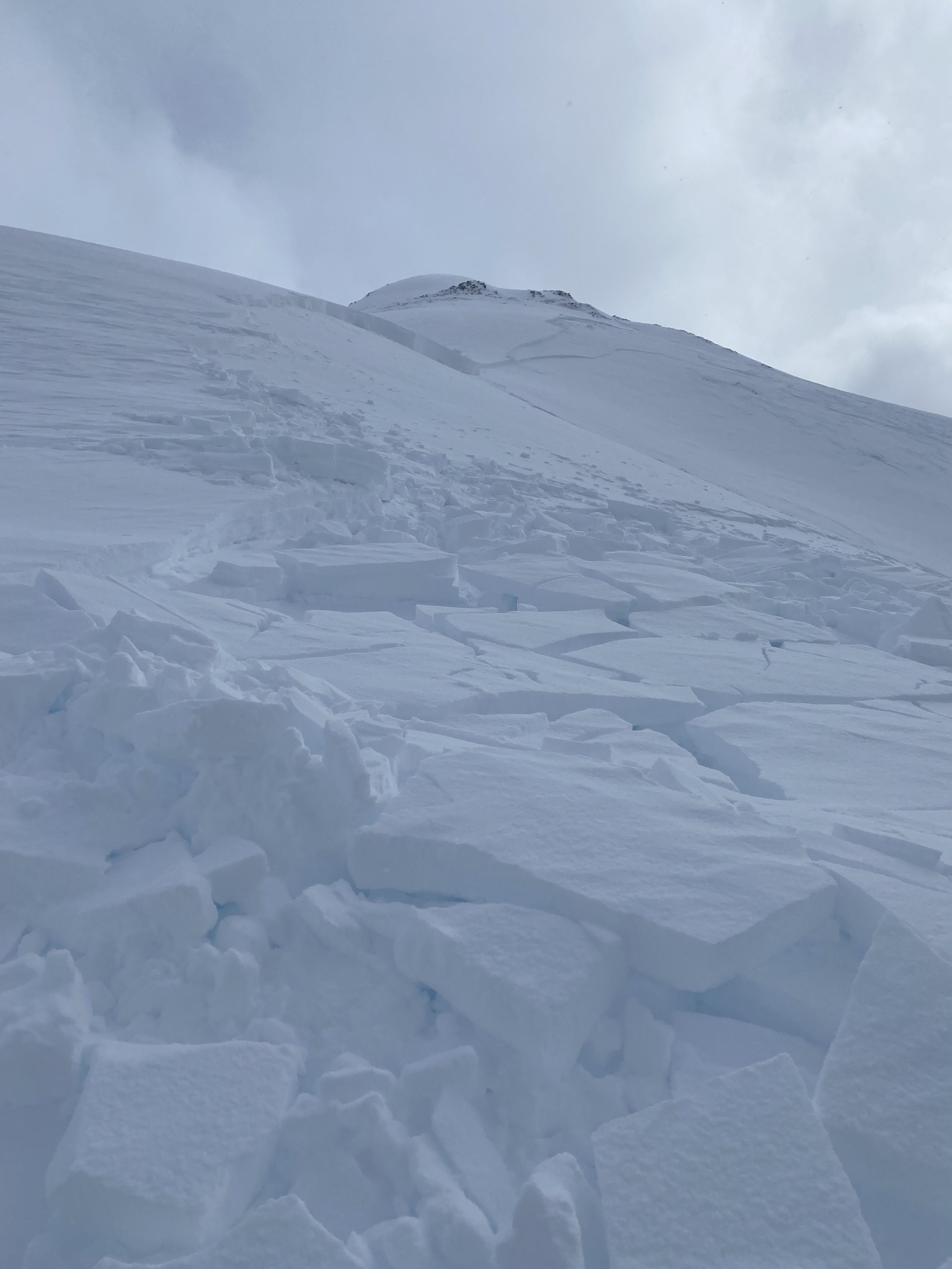
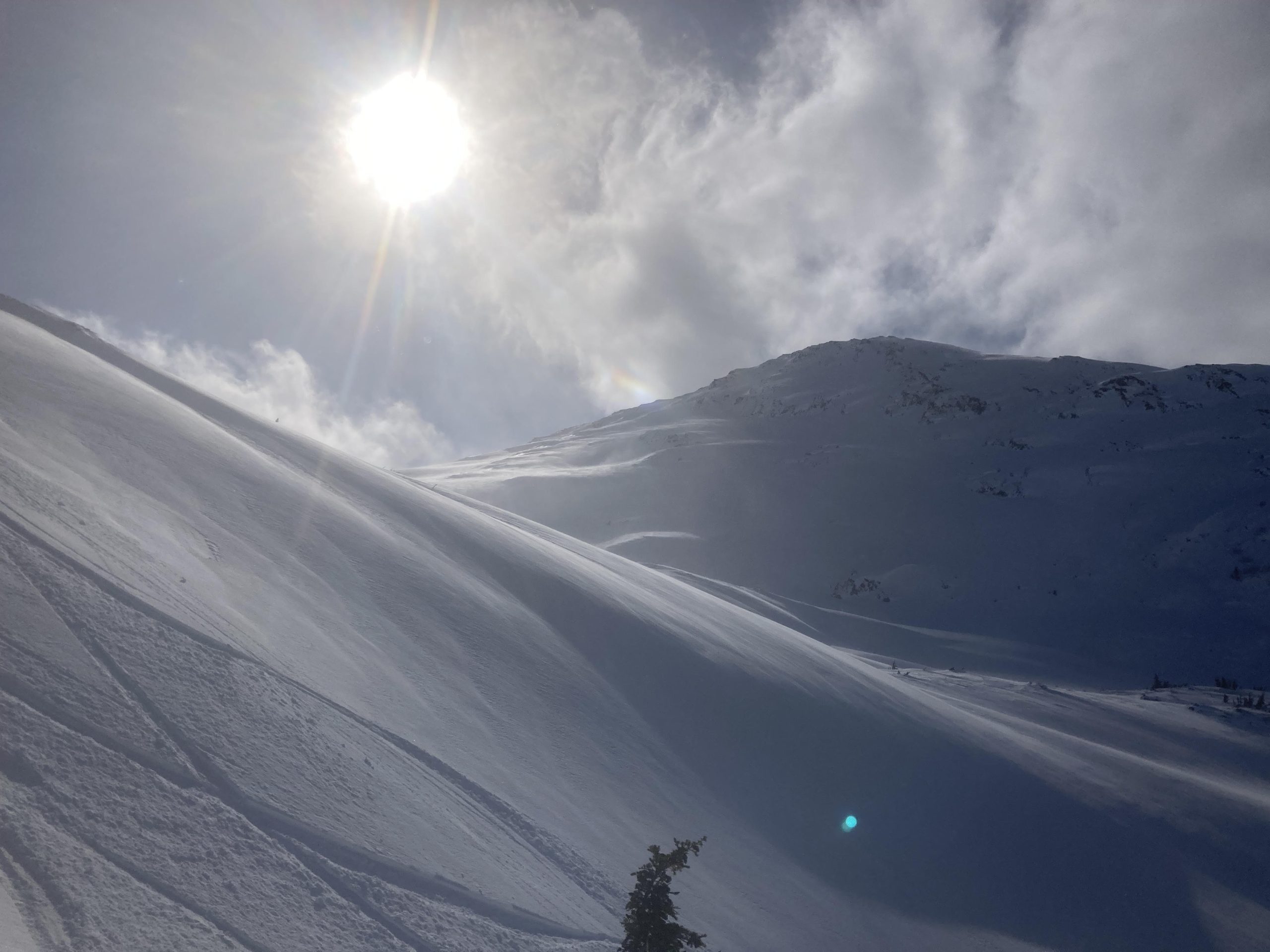
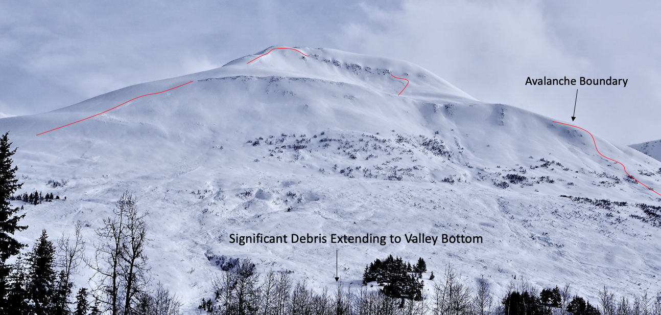
The avalanche danger is CONSIDERABLE above 1000′. It is likely a person will be able to trigger a large avalanche where strong winds have created sensitive wind slabs up to 1-2′ deep. There is a smaller chance that a person may trigger a very large avalanche at the interface between last week’s storm snow and the weak surfaces it fell on. Dangerous avalanche conditions and high uncertainty should be good enough reason to travel cautiously today.

SUMMIT LAKE: The snowpack in the Summit Lake area is weaker and more problematic than our core advisory area. Yesterday a skier remotely triggered a very large avalanche on Templeton, and similar activity is possible today. Traveling in this zone requires an even more conservative mindset than the core advisory area.

Special Announcements

There will be intermittent traffic delays Wednesday March 22, 2023 (tomorrow) on the Seward Highway for Avalanche Hazard Reduction Work. Near mileposts 44 and milepost 45 on the Seward Highway at Summit Lake. Motorists should expect delays of 45 minutes or longer between 10:00 am and 2:00 pm. Updates will be posted on the 511 system. The parking area at milepost 45 will be closed. Please stay clear of the area while avalanche crews are operating. More info on road closures at http://511.alaska.gov/

Transmission inspection using snowmachines:  Chugach Electric Association will be inspecting the transmission lines along the non-motorized side of the Turnagain Pass (between Tincan and Johnson Pass) using snowmachines on one day between Thursday 3/16 and Tuesday 3/21.

The National Weather Service has issued a Blizzard Warning in effect from 10 pm tonight through 6 pm Wednesday.

Tue, March 21st, 2023
Alpine
Above 2,500'
3 - Considerable
Avalanche risk
Treeline
1,000'-2,500'
3 - Considerable
Avalanche risk
Below Treeline
Below 1,000'
2 - Moderate
Avalanche risk
0 - No Rating
1 - Low
2 - Moderate
3 - Considerable
4 - High
5 - Extreme
Avalanche risk Avalanche risk Avalanche risk Avalanche risk Avalanche risk
Travel Advice Generally safe avalanche conditions. Watch for unstable snow on isolated terrain features. Heightened avalanche conditions on specific terrain features. Evaluate snow and terrain carefully; identify features of concern. Dangerous avalanche conditions. Careful snowpack evaluation, cautious route-finding, and conservative decision-making essential. Very dangerous avalanche conditions. Travel in avalanche terrain not recommended. Extraordinarily dangerous avalanche conditions. Avoid all avalanche terrain.
Likelihood of Avalanches Natural and human-triggered avalanches unlikely. Natural avalanches unlikely; human-triggered avalanches possible. Natural avalanches possible; human-triggered avalanches likely. Natural avalanches likely; human-triggered avalanches very likely. Natural and human-triggered avalanches certain.
Avalanche Size and Distribution Small avalanches in isolated areas or extreme terrain. Small avalanches in specific areas; or large avalanches in isolated areas. Small avalanches in many areas; or large avalanches in specific areas; or very large avalanches in isolated areas. Large avalanches in many areas; or very large avalanches in specific areas. Very large avalanches in many areas.
Recent Avalanches

Skies cleared yesterday and we got a sense of avalanche activity from the recent stretch of heavy storms. There was widespread very large avalanche activity, including an avalanche on the west face of Magnum that ran almost to the power lines (details), widespread activity in Lynx creek (details), widespread activity in the Placer/Skookum area, and more activity down near Johnson Pass.

Skiers also found thin but reactive wind slabs forming yesterday on Notch Mtn. near Girdwood. These weren’t yet getting big enough to bury a person.

In addition to all of the recent avalanche activity within our advisory area, skiers remotely triggered a very large avalanche outside of our advisory area in Summit Lake on Templeton (photo below, more details here).

A snapshot of some of the avalanche activity we saw following last week’s storm. Photo submitted anonymously from the Lynx Creek drainage, 03.20.2023.

Large avalanche triggered by a skier remotely on Templeton in the Summit Lake area yesterday. The avalanche was roughly 1000′ wide and ran for 1500 vertical feet. It failed on a layer of weak facets, and the crown was 2′ deep on average, with some parts up to 3.5-4′ deep. Photo: Paul Wunnicke. 03.20.2023

Avalanche Problem 1
  • Wind Slabs
    Wind Slabs
  • Aspect/Elevation
  • Certain
    Very Likely
    Likely
    Possible
    Unlikely
    Likelihood
  • Historic (D4-5)
    Very Large (D3)
    Large (D2)
    Small (D1)
    Size
Wind Slabs
Wind Slab avalanches are the release of a cohesive layer of snow (a slab) formed by the wind. Wind typically transports snow from the upwind sides of terrain features and deposits snow on the downwind side. Wind slabs are often smooth and rounded and sometimes sound hollow, and can range from soft to hard. Wind slabs that form over a persistent weak layer (surface hoar, depth hoar, or near-surface facets) may be termed Persistent Slabs or may develop into Persistent Slabs.

Aspect/Elevation of the Avalanche Problem
Specialists develop a graphic representation of the potential distribution of a particular avalanche problem across the topography. This aspect/elevation rose is used to indicate where the particular avalanche problem is thought to exist on all elevation aspects. Areas where the avalanche problem is thought to exist are colored grey, and it is less likely to be encountered in areas colored white.

Likelihood of Avalanches
Terms such as "unlikely", "likely", and "certain" are used to define the scale, with the chance of triggering or observing avalanches increasing as we move up the scale. For our purposes, "Unlikely" means that few avalanches could be triggered in avalanche terrain and natural avalanches are not expected. "Certain" means that humans will be able to trigger avalanches on many slopes, and natural avalanches are expected.

Size of Avalanches
Avalanche size is defined by the largest potential avalanche, or expected range of sizes related to the problem in question. Assigned size is a qualitative estimate based on the destructive classification system and requires specialists to estimate the harm avalanches may cause to hypothetical objects located in the avalanche track (AAA 2016, CAA 2014). Under this schema, "Small" avalanches are not large enough to bury humans and are relatively harmless unless they carry people over cliffs or through trees or rocks. Moving up the scale, avalanches become "Large" enough to bury, injure, or kill people. "Very Large" avalanches may bury or destroy vehicles or houses, and "Historic" avalanches are massive events capable of altering the landscape.

Signal Word Size (D scale) Simple Descriptor
Small 1 Unlikely to bury a person
Large 2 Can bury a person
Very Large 3 Can destroy a house
Historic 4 & 5 Can destroy part or all of a village
More info at Avalanche.org

We are currently dealing with two very different avalanche problems. The first one is concerning new and windblown snow. This problem is relatively easy to predict- fresh wind slabs that are forming right now will be very reactive and make it likely a person can trigger an avalanche up to around 1-2 feet deep. The second problem lies under all of the snow that fell at the end of last week and has a lot more uncertainty (read on to problem 2 for more).

Ridgetop winds have been blowing 20-30 mph with gusts of 40-60 mph out of the east since late yesterday afternoon. We already had plenty of soft snow on the surface waiting to be blown around, so even if we are only expecting to see a few inches of new snow during the day today, we can expect to see wind slabs getting to be 1-2′ deep or deeper. These fresh slabs will be very sensitive to human triggers, and it is important to recognize and avoid wind-loaded terrain today. Reactive wind slabs tend to give warning signs like cracks shooting out from your snowmachine or skis. Be especially cautious around steep rollovers, gullies, and steep slopes just below ridgelines. It is possible we may see some natural activity as the winds continue to blow this morning, so be sure to pay attention to the slopes above you, as well as the slopes you are traveling on.

The wind was blowing a lot of snow around above treeline on Notch yesterday. Winds continued to ramp up overnight, and wind slabs have gotten bigger and more dangerous as of this morning. 03.20.2023


Avalanche Problem 2
  • Deep Persistent Slabs
    Deep Persistent Slabs
  • Aspect/Elevation
  • Certain
    Very Likely
    Likely
    Possible
    Unlikely
    Likelihood
  • Historic (D4-5)
    Very Large (D3)
    Large (D2)
    Small (D1)
    Size
Deep Persistent Slabs
Deep Persistent Slab avalanches are the release of a thick cohesive layer of hard snow (a slab), when the bond breaks between the slab and an underlying persistent weak layer deep in the snowpack. The most common persistent weak layers involved in deep, persistent slabs are depth hoar or facets surrounding a deeply buried crust. Deep Persistent Slabs are typically hard to trigger, are very destructive and dangerous due to the large mass of snow involved, and can persist for months once developed. They are often triggered from areas where the snow is shallow and weak, and are particularly difficult to forecast for and manage.

Aspect/Elevation of the Avalanche Problem
Specialists develop a graphic representation of the potential distribution of a particular avalanche problem across the topography. This aspect/elevation rose is used to indicate where the particular avalanche problem is thought to exist on all elevation aspects. Areas where the avalanche problem is thought to exist are colored grey, and it is less likely to be encountered in areas colored white.

Likelihood of Avalanches
Terms such as "unlikely", "likely", and "certain" are used to define the scale, with the chance of triggering or observing avalanches increasing as we move up the scale. For our purposes, "Unlikely" means that few avalanches could be triggered in avalanche terrain and natural avalanches are not expected. "Certain" means that humans will be able to trigger avalanches on many slopes, and natural avalanches are expected.

Size of Avalanches
Avalanche size is defined by the largest potential avalanche, or expected range of sizes related to the problem in question. Assigned size is a qualitative estimate based on the destructive classification system and requires specialists to estimate the harm avalanches may cause to hypothetical objects located in the avalanche track (AAA 2016, CAA 2014). Under this schema, "Small" avalanches are not large enough to bury humans and are relatively harmless unless they carry people over cliffs or through trees or rocks. Moving up the scale, avalanches become "Large" enough to bury, injure, or kill people. "Very Large" avalanches may bury or destroy vehicles or houses, and "Historic" avalanches are massive events capable of altering the landscape.

Signal Word Size (D scale) Simple Descriptor
Small 1 Unlikely to bury a person
Large 2 Can bury a person
Very Large 3 Can destroy a house
Historic 4 & 5 Can destroy part or all of a village
More info at Avalanche.org

The 3-6′ of snow we received last week fell on a stout crust on solar aspects and weak, faceted snow on shaded slopes. Yesterday we got eyes on the aftermath of that storm, and there were some impressive avalanches. Now that the storm snow has had a chance to settle for a few days, very large avalanches like that are becoming less likely to trigger and harder to predict. As we continue to load the snowpack with snow and wind today, followed by heavy snow tomorrow, we are adding more and more weight to this questionable interface. If we keep adding stress to the snowpack, something is going to break. The big question for today is whether the extra weight of a person or a snowmachine is enough to trigger a very big avalanche. We haven’t seen avalanches on this layer since the storm wrapped up, but the setup of that much snow sitting on questionable surface has our attention. For today, a person may be more likely to trigger a fresh wind slab near the surface, but this problem may be more concerning. The avalanche problem lies somewhere in the gray area between persistent slab, storm slab, and deep slab. No matter how we classify it, it has the potential to make a very big avalanche, and it is worth considering as you decide where to travel today.

Large avalanches like this one on Magnum were spotted throughout the advisory area following last weekend’s storm. Although these are less likely today, it may still be possible for a person to trigger something like this. 03.19.2023

Weather
Tue, March 21st, 2023

Yesterday: We saw mostly sunny skies yesterday morning, with clouds building yesterday afternoon. Winds started light out of the east but increased all day and have been blowing 20-30 mph with gusts of 40-55 mph overnight. Light snowfall started last night, with 2-6” snow equaling 0.2-0.5” snow water equivalent (SWE) overnight and snow to sea level. The higher totals so far have been recorded near Portage, with lower totals in Girdwood and no new snow as of 5 a.m. at Turnagain Pass. High temperatures were in the mid 20’s to low 30’s F, with the coldest temperatures yesterday morning in the high teens to low 20’s F.

Today: Strong easterly winds will continue through the first half of the day today, with sustained speeds around 30-40 mph and gusts of 40-50 mph expected this morning, then quickly tapering later in the afternoon. Skies will be mostly cloudy, with light snowfall expected to bring 1-3” snow during the day today down to sea level. Temperatures are expected to get up to the mid 20’s to low 30’s F, with lows tonight in the low to mid 20’s F.

Tomorrow: Things are looking to intensify tomorrow, with a stronger low pressure system bringing heavy snowfall and strong winds starting tonight. Most of the area is likely to see 10-18” snow by the end of the day tomorrow, with 2-3’ likely in Portage and Placer between now and tomorrow evening. Winds ramp back up again tonight through tomorrow morning, with sustained speeds of 20-30 mph and gusts of 30-45 mph out of the east. High temperatures should be in the upper 20’s to low 30’s F, with lows tomorrow night in the low to mid 20’s F. We will likely see rain at sea level, but the snow line should stay down around 100-200’.

PRECIPITATION 24-hour data (6am – 6am)

Temp Avg (F) Snow (in) Water (in) Snow Depth (in)
Center Ridge (1880′) 28 1 0.1 96
Summit Lake (1400′) 21 0 0 50
Alyeska Mid (1700′) 30 3 0.3 86
Bear Valley – Portage (132′) 31 6 0.66

RIDGETOP 24-hour data (6am – 6am)

Temp Avg (F) Wind Dir Wind Avg (mph) Wind Gust (mph)
Sunburst (3812′) 17 ENE 18 57
Seattle Ridge (2400′) 22 SE 12 28
Observations
Recent Observations for Turnagain Pass
Date Region Location
04/16/24 Turnagain Observation: Cornbiscuit
04/15/24 Turnagain Observation: Taylor Pass
04/15/24 Turnagain Observation: Seward Highway – Tern Lake to Portage
04/14/24 Turnagain Observation: Sunburst
04/14/24 Turnagain Observation: Turnagain Pass Snomo
04/13/24 Turnagain Observation: Spokane Creek
04/11/24 Turnagain Observation: Tincan
04/10/24 Turnagain Avalanche: Seattle Ridge
04/10/24 Turnagain Observation: Cornbiscuit South Face
04/10/24 Turnagain Avalanche: Tincan
Riding Areas

The riding areas page has moved. Please click here & update your bookmarks.


Subscribe to Turnagain Pass
Avalanche Forecast by Email

This is a general backcountry avalanche advisory issued for Turnagain Arm with Turnagain Pass as the core advisory area. This advisory does not apply to highways, railroads or operating ski areas.