Turnagain Pass Avalanche Forecast
|
![]() ![]() |
The avalanche danger remains MODERATE at all elevations. There is still a chance of triggering a slab avalanche that fails on weak snow buried between 1-3′ feet deep. Additionally, increasing west/northwest winds today may be enough to create some new shallow wind slabs in upper elevation terrain. Watch for blowing snow and changing conditions. Assess the snowpack as you travel, identify areas of concern and evaluate terrain consequences.
LOST LAKE/SNUG/SEWARD: The northwest winds are forecast to be stronger in these areas. Watch for blowing snow and pay attention to terrain selection.
Heading to Hatcher Pass? Be sure to check the Thursday Conditions Summary at hpavalanche.org.
Signal Word | Size (D scale) | Simple Descriptor |
Small | 1 | Unlikely to bury a person |
Large | 2 | Can bury a person |
Very Large | 3 | Can destroy a house |
Historic | 4 & 5 | Can destroy part or all of a village |
With sunshine and soft snow, folks that were out yesterday found the pot o’ gold and a shamrock of day. Overall signs are pointing to a snowpack that is trending to green (LOW danger) and that triggering a persistent slab avalanche is becoming unlikely. It has been a week since the last avalanche large enough to bury and kill a person was triggered on our weak layer/crust combination of concern. There have only been a few small wind slab avalanches reported since then. Over the past week there have been a number people out enjoying the snow with no incident. However, completely trusting a snowpack with obvious persistent weak layers is hard as there is always some uncertainty. There are a couple factors keeping the danger elevated today. One being increasing winds and snow available for transport. The other main data point is that for the second day in row skiers backed off of their objective due to a large collapse (whumpf) and then dug down to find a buried sun crust with facets. On Tuesday it was on Orca and yesterday it was on Goat Mountain. This is a sign of instability combined with poor snowpack structure. Observers on Maxs and Magnum yesterday found similar structure on southerly slopes but no collapses while traveling or propagation in snowpack tests.
Here are some things to keep in mind today:
What to do with this information? As always, pay attention to changing conditions, watch for signs of instability, use good travel protocol, and think about terrain consequences.
Sluffs: Steep slopes that have been sheltered from the wind have around a foot or more of loose snow sitting on top of firm surfaces. It will be easy to trigger dry loose avalanches today, and they can pick up enough volume and speed to carry a person. While it is unlikely they will be big enough to bury you, they can be dangerous if they drag you into terrain traps like cliffs, trees, rocks, or gullies.
Sun effect: Despite cold temperatures and winds, be on the lookout for sun effect on steep southerly slopes, especially under rocky areas at lower elevations. There is sun crust that formed Tuesday on steep southerly slopes. Watch for the surface snow becoming moist and small roller balls.
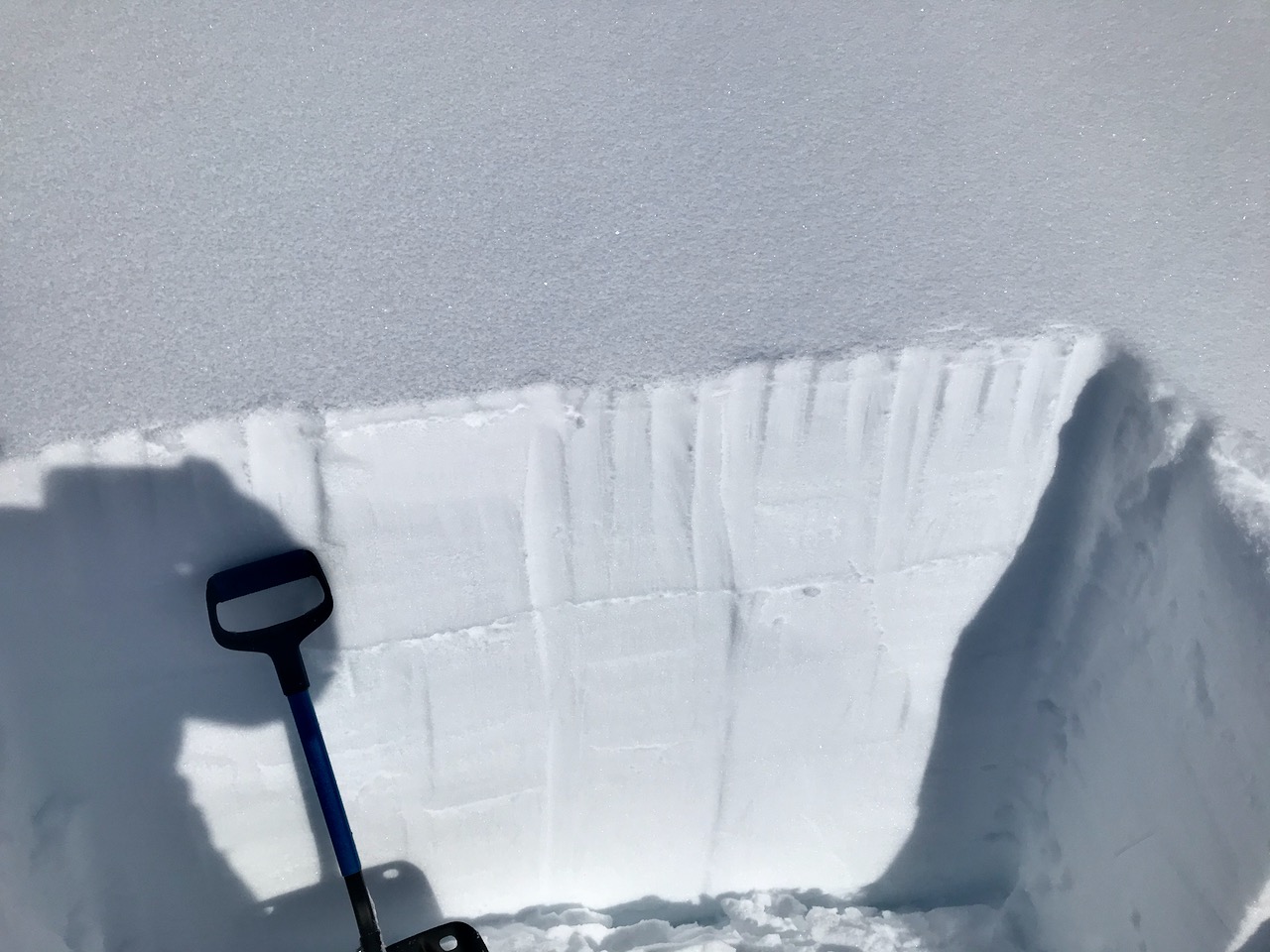
Snow pit on Magnum at 3000′ on a south aspect yesterday, 3.17.21. Note the sun crust that is easy to see. We found a layer of small facets both above and below it.
Signal Word | Size (D scale) | Simple Descriptor |
Small | 1 | Unlikely to bury a person |
Large | 2 | Can bury a person |
Very Large | 3 | Can destroy a house |
Historic | 4 & 5 | Can destroy part or all of a village |
The west/northwest winds are expected to increase today which may increase the likelihood of triggering a small wind slab avalanche. These will have the potential to step down to the weak layers discussed above, creating a larger avalanche. As we have mentioned before, this wind flow direction is tricky for Turnagain Pass. It can funnel through the Pass from the south and load north aspects on the non-motorized side, while at the same time load the SE face of Seattle Ridge. It can also split around the Pass and not affect much of the terrain in the heart of Turnagain at all. This wind pattern also increases through channeled terrain and can be more pronounced in Crow Pass and Portage. Be aware of active wind-loading, and keep an eye open for signs that a slope has been recently loaded. This will feel like stiffer snow at the surface, and may have the appearance of a smooth, rounded pillow. If you experience any collapsing (‘whumpfing’) or cracks shooting out from you or your machine, the snowpack is giving you clear signs that it is capable of avalanching.
Yesterday: Skies were partly sunny with light northwest winds and temperatures in the single digits to low teens at upper elevations and mid 20°Fs near sea level. Overnight skies were partly cloudy and temperatures were in the single digits and low teens. Northwest winds were light.
Today: Skies will be partly sunny with a slight chance of flurries in the morning. West/northwest winds will be 5-10 mph increasing in the afternoon to 10-20 mph with gusts into the 30s. Temperatures will be in the single digits to mid teens. Overnight skies will be mostly clear. Northwest winds continue to blow 15-20 mph with gusts into the 30s. Temperatures will be in the single digits.
Tomorrow: Sunny skies with highs in the teens to mid 20°Fs. Winds will be westerly 5-10 mph becoming calm in the afternoon. There looks to be a slight warming trend for the weekend with a slight chance of snow Saturday and sunshine on Sunday.
PRECIPITATION 24-hour data (6am – 6am)
Temp Avg (F) | Snow (in) | Water (in) | Snow Depth (in) | |
---|---|---|---|---|
Center Ridge (1880′) | 11 | 0 | 0 | 114 |
Summit Lake (1400′) | 8 | 0 | 0 | 46 |
Alyeska Mid (1700′) | 12 | 0 | 0 | 117 |
RIDGETOP 24-hour data (6am – 6am)
Temp Avg (F) | Wind Dir | Wind Avg (mph) | Wind Gust (mph) | |
---|---|---|---|---|
Sunburst (3812′) | 2 | NW | 6 | 20 |
Seattle Ridge (2400′) | 8 | NW | 3 | 15 |
Date | Region | Location | Observer |
---|---|---|---|
05/22/23 | Turnagain | Avalanche: Tincan | Nick D'Alessio |
05/12/23 | Turnagain | Avalanche: Tincan, Sunburst, Magnum, Cornbiscuit | Heather Thamm |
05/07/23 | Turnagain | Observation: Tincan – Bear Tracks | CNFAIC Staff |
05/05/23 | Turnagain | Observation: Seattle Ridge | AS/ WW Forecaster |
05/02/23 | Turnagain | Observation: Cornbiscuit | Schauer/ Sturgess Forecaster |
05/02/23 | Turnagain | Observation: Seward Hwy Turnagain Pass | Joel Curtis |
04/30/23 | Turnagain | Observation: Magnum | Ayla, Kit Crosby, Barton |
04/29/23 | Turnagain | Observation: Tincan | John Sykes |
04/28/23 | Turnagain | Avalanche: Taylor Pass/Pastoral | Schauer/ Creighton Forecaster |
04/28/23 | Turnagain | Avalanche: Tincan | Andy Moderow |
Status of riding areas across the Chugach NF is managed by the Glacier and Seward Ranger Districts, not avalanche center staff. Riding area information is posted as a public service to our users and updated based on snow depth and snow density to prevent resource damage at trailhead locations. Riding area questions contact: mailroom_r10_chugach@fs.fed.us
Area | Status | Weather & Riding Conditions |
---|---|---|
Glacier District |
Subscribe to Turnagain Pass
Avalanche Forecast by Email
This is a general backcountry avalanche advisory issued for Turnagain Arm with Turnagain Pass as the core advisory area. This advisory does not apply to highways, railroads or operating ski areas.