Turnagain Pass Avalanche Forecast RSS

Archives
ARCHIVED FORECAST - All forecasts expire after 24 hours from the posting date/time.
Issued
Fri, March 17th, 2023 - 7:00AM
Expires
Sat, March 18th, 2023 - 7:00AM
Forecaster
John Sykes
Avalanche risk The Bottom Line

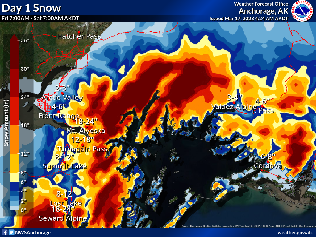
The avalanche danger will rise to HIGH today at all elevations. Up to a foot or more of snow and strong winds are expected, which will rapidly increase the avalanche danger. Natural and human triggered avalanches 1-3′ deep in areas with active wind loading are very likely. In areas sheltered from the wind natural and human triggered avalanches 1-2′ deep are likely because the new snow from earlier this week did not bond well with the old snow surface. We recommend avoiding avalanche terrain today and being aware of any overhead slopes that could release naturally and run out down to lower elevations.

SUMMIT LAKE / LOST LAKE / SNUG HARBOR: Heavy snowfall is expected across the eastern Kenai Penninsula, with up to a foot or more new snow in favored areas. Avalanche danger will increase rapidly with strong winds and snowfall and we recommend avoiding avalanche terrain while the snowpack adjusts to this new load.

Special Announcements

Transmission inspection using snowmachines:  Chugach Electric Association will be inspecting the transmission lines along the non-motorized side of the Turnagain Pass (between Tincan and Johnson Pass) using snowmachines on one day between Thursday 3/16 and Tuesday 3/21.

Turnagain Pass Avalanche Awareness Day – this Saturday!
On March 18th swing by the Turnagain Pass moto lot on your way to or from your backcountry ride or ski!! Test your beacon skills, chow down on hot dogs, and bring your questions for CNFAIC forecasters. The Alaska Avalanche School will be there along with a chance to demo snowmachines from Alaska Mining and Diving Supply and Anchorage Yamaha and Polaris. More details HERE

Thanks to our sponsors!
Fri, March 17th, 2023
Alpine
Above 2,500'
High (4)
Avalanche risk
Treeline
1,000'-2,500'
High (4)
Avalanche risk
Below Treeline
Below 1,000'
High (4)
Avalanche risk
Alpine
Above 2,500'
Avalanche risk
High (4)
Treeline
1,000'-2,500'
Avalanche risk
High (4)
Below Treeline
Below 1,000'
Avalanche risk
High (4)
Danger Scale:
No Rating (0)
Low (1)
Moderate (2)
Considerable (3)
High (4)
Extreme (5)
Recent Avalanches

There were several recent avalanches reported yesterday that were all on the small side (D1). Two avalanches were triggered in the Tincan Common area on south facing slopes where the new snow was not bonding well to the old icy snow surface. Similarly on Sunburst there was another southern aspect with a small surface snow avalanche. In areas that received consistent sunshine yesterday dry loose avalanches triggered by the sun on southern aspects were also observed.

Skier triggered avalanche on the south aspect of Tincan, the skier was not caught and was able to ski off the slope. Photo 3.16.23 from Elias Neuffer

Another skier triggered avalanche on Tincan Common on a southern aspect where no one was caught or buried. Photo from 3.16.23 by Catherine Rocchi

Avalanche Problem 1
  • Storm Slabs
    Storm Slabs
  • Aspect/Elevation
  • Almost Certain
    Very Likely
    Likely
    Possible
    Unlikely
    Likelihood
  • Historic (D4-5)
    Very Large (D3)
    Large (D2)
    Small (D1)
    Size
Storm Slabs
Storm Slab avalanches are the release of a cohesive layer (a slab) of new snow that breaks within new snow or on the old snow surface. Storm-slabs typically last between a few hours and few days (following snowfall). Storm-slabs that form over a persistent weak layer (surface hoar, depth hoar, or near-surface facets) may be termed Persistent Slabs or may develop into Persistent Slabs.

Aspect/Elevation of the Avalanche Problem
Specialists develop a graphic representation of the potential distribution of a particular avalanche problem across the topography. This aspect/elevation rose is used to indicate where the particular avalanche problem is thought to exist on all elevation aspects. Areas where the avalanche problem is thought to exist are colored grey, and it is less likely to be encountered in areas colored white.

Likelihood of Avalanches
Terms such as "unlikely", "likely", and "certain" are used to define the scale, with the chance of triggering or observing avalanches increasing as we move up the scale. For our purposes, "Unlikely" means that few avalanches could be triggered in avalanche terrain and natural avalanches are not expected. "Certain" means that humans will be able to trigger avalanches on many slopes, and natural avalanches are expected.

Size of Avalanches
Avalanche size is defined by the largest potential avalanche, or expected range of sizes related to the problem in question. Assigned size is a qualitative estimate based on the destructive classification system and requires specialists to estimate the harm avalanches may cause to hypothetical objects located in the avalanche track (AAA 2016, CAA 2014). Under this schema, "Small" avalanches are not large enough to bury humans and are relatively harmless unless they carry people over cliffs or through trees or rocks. Moving up the scale, avalanches become "Large" enough to bury, injure, or kill people. "Very Large" avalanches may bury or destroy vehicles or houses, and "Historic" avalanches are massive events capable of altering the landscape.

Signal Word Size (D scale) Simple Descriptor
Small 1 Unlikely to bury a person
Large 2 Can bury a person
Very Large 3 Can destroy a house
Historic 4 & 5 Can destroy part or all of a village
More info at Avalanche.org

Heavy snowfall and strong winds will start again today which will rapidly increase avalanche danger. We are expecting 10-12″ of new snow during the day with periods of very heavy snowfall. The highest snowfall totals are expected to be near Girdwood and areas closer to Prince William Sound, like Portage. Wind speeds should be in the 40-60 mph range at upper elevations with stronger gusts. This rapid loading of the snowpack, which is still adjusting to the last foot or more of new snow that fell in many areas on Wednesday, will likely be enough to cause widespread natural avalanches 1-3′ deep in areas with active wind loading. In areas sheltered from the wind natural and human triggered avalanches avalanches 1-2′ deep are likely because the last round of snow did not bond very well to the old snow surface.

After the last round of snowfall we saw avalanche activity on southern aspects that had a sun crust on the old snow surface. With more stress added to the snowpack today it is possible that we could also start to see larger and more connected avalanches releasing on shaded slopes that have a buried weak layer of facets underneath the last round of snow. In general today is a good day to step back from avalanche terrain and give the mountains some space to adjust to the incoming storm. We recommend avoiding avalanche terrain, especially in areas with active wind loading, and being very aware of any avalanche paths overhead that could release naturally.

NWS forecast snow totals from Friday morning to Saturday morning. Graphic from NWS Anchorage 3.17.23

Additional Concern
  • Persistent Slabs
    Persistent Slabs
Persistent Slabs
Persistent Slab avalanches are the release of a cohesive layer of snow (a slab) in the middle to upper snowpack, when the bond to an underlying persistent weak layer breaks. Persistent layers include: surface hoar, depth hoar, near-surface facets, or faceted snow. Persistent weak layers can continue to produce avalanches for days, weeks or even months, making them especially dangerous and tricky. As additional snow and wind events build a thicker slab on top of the persistent weak layer, this avalanche problem may develop into a Deep Persistent Slab.
More info at Avalanche.org

In areas of the forecast region with a thinner overall snowpack, like near Johnson Pass, there is the potential for avalanches on deeper buried weak layers that we are still concerned with. The rapid loading today with new snow and wind could be enough to reactivate these buried weak layers and larger avalanches with wide propagation are possible. We recommend an extra conservative mindset in these areas because there is the potential for a large avalanche to release at upper elevations and run into lower elevations.

Weather
Fri, March 17th, 2023

Yesterday: Mix of cloudy conditions and periods of broken skies with sun poking through. Turnagain Pass and the Portage/Placer area picked up another 0.2-0.3″ of water which should be roughly 2-3″ of snow. Winds were moderate to light at lower elevations and stronger at upper elevations. Sunburst had average wind speeds of 10-15 mph and gusts of 15-30 mph with occasional stronger gusts up to 50 mph. Temperatures remained in the teens to mid 20s F with snow falling down to sea level.

Today: Heavy snowfall and strong winds are expected to pick up again this morning. 10-12″ of new snowfall is forecast during the day today in Turnagain Pass and Girdwood with higher totals expected in areas closer to Prince William Sound. Over the next 24 hours Turnagain Pass could receive up to 12-18″ of new snow, with Girdwood estimated at 18-24″, and Portage possibly closer to 18-30″. Accompanying all the new snow will we wind speed averaging 40-60 mph at upper elevations with stronger gusts. Snow line could creep up to about 500′ today with some warmer temperatures accompanying this low pressure system.

Tomorrow: Light snowfall is expected to continue during the day tomorrow with mostly cloudy skies. An additional 2-3″ of snowfall is possible during the day and then another strong pulse of snowfall is expected to start late Saturday into Sunday. This second strong pulse of moisture could bring up to another 6-10″ of snow by Sunday morning. Even stronger winds will accompany the second pulse of moisture with wind speeds reaching 80 mph at upper elevations on Saturday evening through Sunday morning. Storm totals from Friday morning through Sunday morning could be as high as 20-25″ for Turnagain Pass and Girdwood, and closer to 30-36″ in Portage. These might be optimistic values, but the weather models seems to all agree that at least some heavy snowfall will impact the area this weekend.

PRECIPITATION 24-hour data (6am – 6am)

Temp Avg (F) Snow (in) Water (in) Snow Depth (in)
Center Ridge (1880′) 25 2 0.2 76
Summit Lake (1400′) 24 1 0.1 40
Alyeska Mid (1700′) 24 0 0 66
Bear Valley – Portage (132′) 27 2 0.23

RIDGETOP 24-hour data (6am – 6am)

Temp Avg (F) Wind Dir Wind Avg (mph) Wind Gust (mph)
Sunburst (3812′) 13 NE 13 48
Seattle Ridge (2400′) 18 SE 4 12
Observations
Recent Observations for Turnagain Pass
Date Region Location
05/22/23 Turnagain Avalanche: Tincan
05/12/23 Turnagain Avalanche: Tincan, Sunburst, Magnum, Cornbiscuit
05/07/23 Turnagain Observation: Tincan – Bear Tracks
05/05/23 Turnagain Observation: Seattle Ridge
05/02/23 Turnagain Observation: Cornbiscuit
05/02/23 Turnagain Observation: Seward Hwy Turnagain Pass
04/30/23 Turnagain Observation: Magnum
04/29/23 Turnagain Observation: Tincan
04/28/23 Turnagain Avalanche: Taylor Pass/Pastoral
04/28/23 Turnagain Avalanche: Tincan
Riding Areas
Updated Sat, September 23rd, 2023

Status of riding areas across the Chugach NF is managed by the Glacier and Seward Ranger Districts, not avalanche center staff. Riding area information is posted as a public service to our users and updated based on snow depth and snow density to prevent resource damage at trailhead locations. Riding area questions contact: mailroom_r10_chugach@fs.fed.us

Area Status Weather & Riding Conditions
Glacier District
Johnson Pass
Closed
Scheduled opening per Chugach National Forest plan December 1. Subject to adequate snow cover.
Placer River
Closed
Scheduled opening per Chugach National Forest plan December 1. Subject to adequate snow cover.
Skookum Drainage
Closed
Scheduled opening per Chugach National Forest plan December 1. Subject to adequate snow cover.
Turnagain Pass
Closed
Scheduled opening on the Wednesday before Thanksgiving per Chugach National Forest plan. Subject to adequate snow cover.
Twentymile
Closed
Scheduled opening per Chugach National Forest plan December 1. Subject to adequate snow cover.
Seward District
Carter Lake
Closed
Scheduled opening per Chugach National Forest plan December 1. Subject to adequate snow cover.
Lost Lake Trail
Closed
Scheduled opening per Chugach National Forest plan December 1. Subject to adequate snow cover.
Primrose Trail
Closed
Scheduled opening per Chugach National Forest plan December 1. Subject to adequate snow cover.
Resurrection Pass Trail
Closed
Scheduled opening per Chugach National Forest plan December 1. Subject to adequate snow cover.
Snug Harbor
Closed
Scheduled opening per Chugach National Forest plan December 1. Subject to adequate snow cover.
South Fork Snow River Corridor
Closed
Scheduled opening per Chugach National Forest plan December 1. Subject to adequate snow cover.
Summit Lake
Closed
Scheduled opening per Chugach National Forest plan December 1. Subject to adequate snow cover.

Subscribe to Turnagain Pass
Avalanche Forecast by Email

This is a general backcountry avalanche advisory issued for Turnagain Arm with Turnagain Pass as the core advisory area. This advisory does not apply to highways, railroads or operating ski areas.