Turnagain Pass
|
![]() ![]() |
The avalanche danger is MODERATE today, and it remains possible to trigger an avalanche on weak snow buried 1-3’ deep. The most likely places to trigger an avalanche will be on steep slopes that have seen recent wind-loading, with stiffer snow on the surface. Pay attention to clear warning signs of instability like shooting cracks, collapsing, and recent avalanche activity, and avoid consequential terrain where triggering an avalanche would have severe consequences.
LOST LAKE/SNUG/SEWARD: Stronger winds are expected to continue today, increasing the likelihood of wind slab avalanches. Extra caution is advised in the mountains around Lost Lake, Snug Harbor and Seward.
![]() |
![]() |
![]() |
![]() |
![]() |
|
Travel Advice | Generally safe avalanche conditions. Watch for unstable snow on isolated terrain features. | Heightened avalanche conditions on specific terrain features. Evaluate snow and terrain carefully; identify features of concern. | Dangerous avalanche conditions. Careful snowpack evaluation, cautious route-finding, and conservative decision-making essential. | Very dangerous avalanche conditions. Travel in avalanche terrain not recommended. | Extraordinarily dangerous avalanche conditions. Avoid all avalanche terrain. |
Likelihood of Avalanches | Natural and human-triggered avalanches unlikely. | Natural avalanches unlikely; human-triggered avalanches possible. | Natural avalanches possible; human-triggered avalanches likely. | Natural avalanches likely; human-triggered avalanches very likely. | Natural and human-triggered avalanches certain. |
Avalanche Size and Distribution | Small avalanches in isolated areas or extreme terrain. | Small avalanches in specific areas; or large avalanches in isolated areas. | Small avalanches in many areas; or large avalanches in specific areas; or very large avalanches in isolated areas. | Large avalanches in many areas; or very large avalanches in specific areas. | Very large avalanches in many areas. |
Pete’s North: A skier triggered an avalanche on a wind-loaded slope near treeline at Pete’s North yesterday. The skier was able to self-arrest and was uninjured. More details here.
Skier-triggered avalanche on Pete’s North yesterday. 03.15.2021. Photo submitted anonymously.
Signal Word | Size (D scale) | Simple Descriptor |
Small | 1 | Unlikely to bury a person |
Large | 2 | Can bury a person |
Very Large | 3 | Can destroy a house |
Historic | 4 & 5 | Can destroy part or all of a village |
It is still possible to trigger an avalanche on facets and surface hoar that are now buried 1-3’ deep from the past week’s snow and wind. The few inches of snow over the past two days is not adding any significant stress to the snowpack, but these persistent weak layers still need more time to heal. The most likely slopes to trigger a persistent slab avalanche will be those that have seen recent wind loading, with relatively stiff snow at the surface.
As we get further out from the last major loading event, we are going to get less direct feedback from the potentially unstable snowpack. This leads to a higher level of uncertainty while trying to assess stability, which requires maintaining wider margins of safety. For now, that means sticking to terrain that minimizes the consequences if you do trigger an avalanche. You can do this by avoiding slopes with exposure to terrain traps like cliffs, rocks, trees or gullies, and staying off big terrain for a little while longer. Just like we saw with the weak layers we dealt with for most of February, this will get better over time and we will once again be able to step out into bigger terrain. But for now we just need to be patient, and give the snowpack a little more time to gain strength.
Wind Slabs: The winds are expected to bump up slightly from what we saw yesterday, which may increase the likelihood of triggering a wind slab avalanche 6-12” deep. While these are not expected to be particularly large today, they will have the potential to step down to the weak layers discussed above, creating a larger avalanche. Be aware of active wind loading, and keep an eye open for signs that a slope has been recently loaded. This will feel like stiffer snow at the surface, and may have the appearance of a smooth, rounded pillow. If you experience any collapsing (‘whumpfing’) or cracks shooting out from you or your machine, the snowpack is giving you clear signs that it is capable of avalanching.
Sluffs: Steep slopes that have been sheltered from the wind have around a foot or more of loose snow sitting on top of firm surfaces. It will be easy to trigger dry loose avalanches today, and they can pick up enough volume and speed to carry a person. While it is unlikely they will be big enough to bury you, they can be dangerous if they drag you into terrain traps like cliffs, trees, rocks, or gullies.
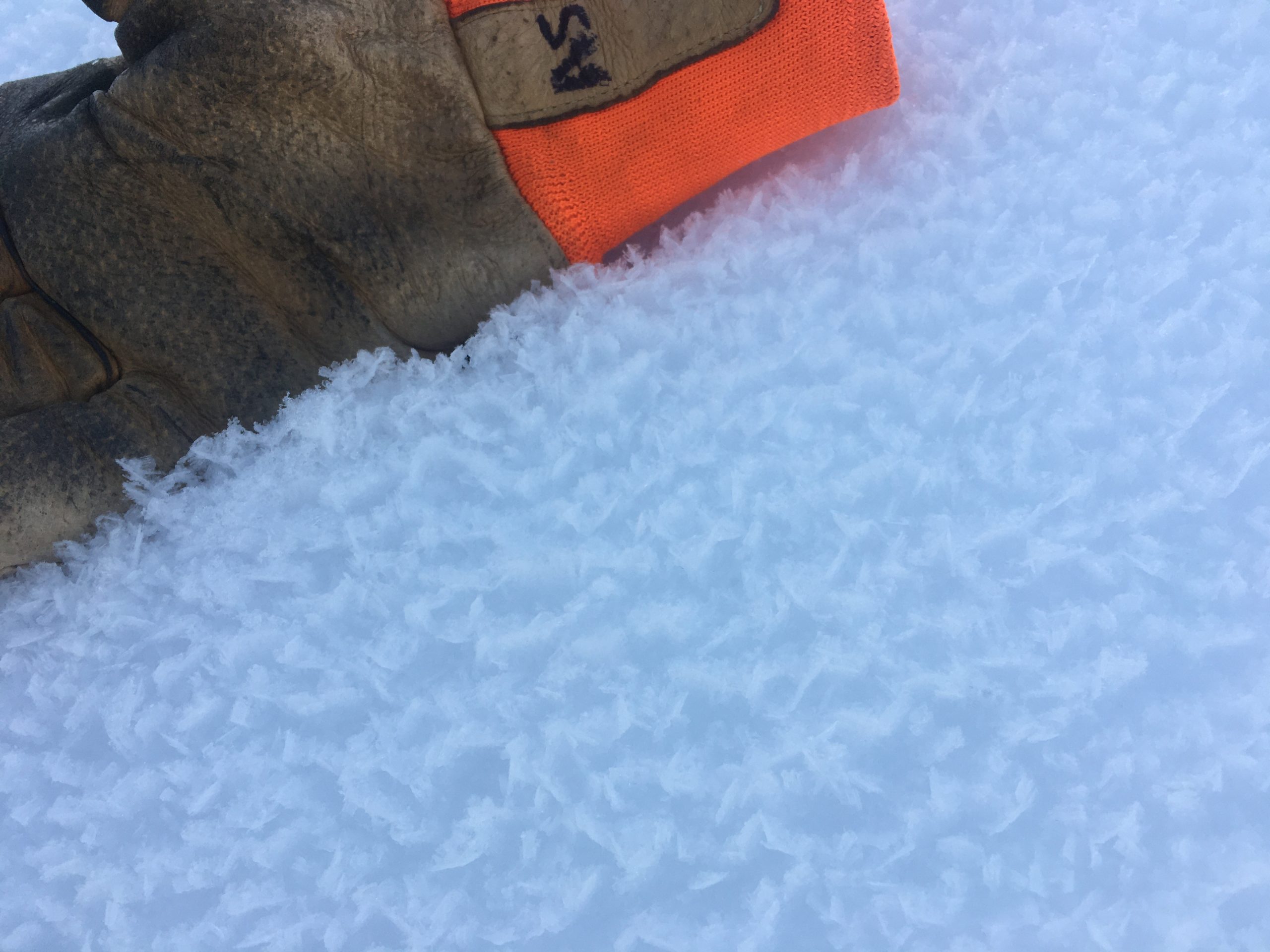
This weak layer of surface hoar was buried on 3/9, and is now 1-3′ deep. Photo taken 03.06.2021.
Yesterday: Light snowfall trickled in under cloudy skies for most of the day, resulting in 1-2” of accumulation over the past 24 hours. High temperatures reached the low teens to upper 20’s F, and overnight lows dipped down to the single digits to low teens F. Winds were light at 5-10 mph out of the west, with gusts to around 20 mph.
Today: A few lingering flurries will taper off this morning, and clouds will slowly begin to clear later in the afternoon. Highs are expected in the low teens to low 20’s F, with westerly winds at 5-10 mph. Winds are expected to be slightly stronger towards the south end of Turnagain Pass.
Tomorrow: Skies continue to clear overnight, with mostly sunny skies expected tomorrow. Northwesterly winds are expected to increase slightly, with sustained speeds around 10-20 mph. High temperatures are expected in the low to mid teens F.
PRECIPITATION 24-hour data (6am – 6am)
Temp Avg (F) | Snow (in) | Water (in) | Snow Depth (in) | |
---|---|---|---|---|
Center Ridge (1880′) | 18 | 1 | 0.1 | 115 |
Summit Lake (1400′) | 15 | 1 | 0.2 | 47 |
Alyeska Mid (1700′) | 15 | 2 | 0.1 | 119 |
RIDGETOP 24-hour data (6am – 6am)
Temp Avg (F) | Wind Dir | Wind Avg (mph) | Wind Gust (mph) | |
---|---|---|---|---|
Sunburst (3812′) | 6 | W | 6 | 16 |
Seattle Ridge (2400′) | 10 | N | 2 | 8 |
Date | Region | Location | Observer |
---|---|---|---|
10/27/24 | Turnagain | Observation: Tincan | Michael Kerst |
10/21/24 | Turnagain | Observation: Turnagain Pass Road Observation | Trevor Clayton |
10/19/24 | Turnagain | Observation: Tincan – Below Todds Run | Andy Moderow |
10/18/24 | Turnagain | Observation: Taylor Pass | Eli Neuffer |
10/15/24 | Turnagain | Observation: Tincan Common | John Sykes Forecaster |
10/14/24 | Turnagain | Avalanche: Tincan | CNFAC Staff |
05/13/24 | Turnagain | Observation: Eddie’s, Sunburst, Seattle, Cornbiscuit, Pete’s South | H Thamm |
05/13/24 | Turnagain | Observation: Turnagain Pass non-motorized side | Amy Holman |
05/12/24 | Turnagain | Observation: Warm up Bowl | Tony Naciuk |
05/07/24 | Turnagain | Observation: Turnagain Pass Wet Slabs | A S |
The riding areas page has moved. Please click here & update your bookmarks.
Subscribe to Turnagain Pass
Avalanche Forecast by Email