Turnagain Pass RSS

Archives
ARCHIVED - Forecasts expire after 24 hours.
Issued
Thu, March 12th, 2020 - 7:00AM
Expires
Fri, March 13th, 2020 - 7:00AM
Forecaster
Aleph Johnston-Bloom
Avalanche risk The Bottom Line

The avalanche danger remain MODERATE at all elevations.  Triggering a slab around 1-2′ deep that fails on buried surface hoar is possible, especially in steep wind loaded terrain. Watch for sluffing on steep protected slopes and signs of surface heating on solar aspects. Evaluate snow and terrain carefully.

SUMMIT LAKE to LOST LAKE and SEWARDSouth of Turnagain Pass was more impacted by the outflow winds of the past two days. Natural avalanches were observed on Tuesday.  In much of the terrain the snowpack is shallower with buried weak layers of snow. Triggering a large avalanche is possible and extra caution is advised.

Special Announcements

Save the date, March 21st! Turngagain Takeover: CNFAIC Avalanche Awareness at the Pass. CNFAIC is hosting an expo style avalanche awareness day for all ages and modes of backcountry travel at the motorized parking lot on Turnagain Pass from 11 am – 5 pm.  This event will be joined by many of our supporting businesses and organizations in our effort to promote avalanche safety. Practice with your rescue gear, grab a hot dog and check out all the cool new equipment on display! Bring your friends and family! Hope to see you all there! Check out the full schedule HERE. 

Thu, March 12th, 2020
Alpine
Above 2,500'
2 - Moderate
Avalanche risk
Treeline
1,000'-2,500'
2 - Moderate
Avalanche risk
Below Treeline
Below 1,000'
2 - Moderate
Avalanche risk
0 - No Rating
1 - Low
2 - Moderate
3 - Considerable
4 - High
5 - Extreme
Avalanche risk Avalanche risk Avalanche risk Avalanche risk Avalanche risk
Travel Advice Generally safe avalanche conditions. Watch for unstable snow on isolated terrain features. Heightened avalanche conditions on specific terrain features. Evaluate snow and terrain carefully; identify features of concern. Dangerous avalanche conditions. Careful snowpack evaluation, cautious route-finding, and conservative decision-making essential. Very dangerous avalanche conditions. Travel in avalanche terrain not recommended. Extraordinarily dangerous avalanche conditions. Avoid all avalanche terrain.
Likelihood of Avalanches Natural and human-triggered avalanches unlikely. Natural avalanches unlikely; human-triggered avalanches possible. Natural avalanches possible; human-triggered avalanches likely. Natural avalanches likely; human-triggered avalanches very likely. Natural and human-triggered avalanches certain.
Avalanche Size and Distribution Small avalanches in isolated areas or extreme terrain. Small avalanches in specific areas; or large avalanches in isolated areas. Small avalanches in many areas; or large avalanches in specific areas; or very large avalanches in isolated areas. Large avalanches in many areas; or very large avalanches in specific areas. Very large avalanches in many areas.
Recent Avalanches

We received a report of a skier triggered avalanche in Palmer Creek yesterday. The crown was 12-18″ deep and was on a wind loaded west facing slope. Observers also reported recent wind triggered avalanches on the Crow Pass trail.

Skier triggered avalanche in Palmer Creek. Cracking extends past the crown. 3.11.20.

Recent avalanche observed from the Crow Pass trail. Believed to be a natural triggered by the wind on Tuesday. Photo taken 3.11.10 Allen Dahl

Avalanche Problem 1
  • Persistent Slabs
    Persistent Slabs
  • Certain
    Very Likely
    Likely
    Possible
    Unlikely
    Likelihood
  • Historic (D4-5)
    Very Large (D3)
    Large (D2)
    Small (D1)
    Size
Persistent Slabs
Persistent Slab avalanches are the release of a cohesive layer of snow (a slab) in the middle to upper snowpack, when the bond to an underlying persistent weak layer breaks. Persistent layers include: surface hoar, depth hoar, near-surface facets, or faceted snow. Persistent weak layers can continue to produce avalanches for days, weeks or even months, making them especially dangerous and tricky. As additional snow and wind events build a thicker slab on top of the persistent weak layer, this avalanche problem may develop into a Deep Persistent Slab.

Likelihood of Avalanches
Terms such as "unlikely", "likely", and "certain" are used to define the scale, with the chance of triggering or observing avalanches increasing as we move up the scale. For our purposes, "Unlikely" means that few avalanches could be triggered in avalanche terrain and natural avalanches are not expected. "Certain" means that humans will be able to trigger avalanches on many slopes, and natural avalanches are expected.

Size of Avalanches
Avalanche size is defined by the largest potential avalanche, or expected range of sizes related to the problem in question. Assigned size is a qualitative estimate based on the destructive classification system and requires specialists to estimate the harm avalanches may cause to hypothetical objects located in the avalanche track (AAA 2016, CAA 2014). Under this schema, "Small" avalanches are not large enough to bury humans and are relatively harmless unless they carry people over cliffs or through trees or rocks. Moving up the scale, avalanches become "Large" enough to bury, injure, or kill people. "Very Large" avalanches may bury or destroy vehicles or houses, and "Historic" avalanches are massive events capable of altering the landscape.

Signal Word Size (D scale) Simple Descriptor
Small 1 Unlikely to bury a person
Large 2 Can bury a person
Very Large 3 Can destroy a house
Historic 4 & 5 Can destroy part or all of a village
More info at Avalanche.org

Today is an avalanche problem transition day. Since March 2nd wind slab has been Problem #1. We have had a series of northwest outflow events and with a swing or two back to elevated southeast winds. Today the winds are forecast to ease off and become calm. Could you find a lingering wind slab that just involves layers of wind deposited snow not bonding in wind loaded terrain? Yes. However, the main concern is triggering an avalanche that fails on buried surface hoar which is considered a persistent weak layer. This layer was buried around Leap Day and has been found in snow pits around much of the forecast area. It is generally around 1-2′ below the surface. The surface hoar is the suspected weak layer in the Lynx avalanche last Thursday, and some small skier triggered avalanches around Girdwood and potentially the avalanche triggered in Palmer creek yesterday. It is most likely going to be an issue where it is buried under wind affected snow forming a slab. Hence the transition from a wind slab to persistent slab. Additionally, the surface hoar layer may also be reactive as warm temperatures and sunshine change the character of the soft snow into a slab in more protected areas.

A challenge with a surface hoar layer is that it may not be widespread across terrain and may or may not be an issue depending on what the snow below the layer of surface hoar is like. Surface hoar that formed on hard snow or a crust is more of a concern. You could happen to hit a zone with the lurking layer and trigger an avalanche or not!  What does all this mean today? Pay attention to terrain features that look loaded or pillowed, watch for cracking or collapsing, and terrain with hard snow over a softer layer. Use small test slopes and hand pits to see if the snowpack is reactive. Don’t forget this type of avalanche may be triggered remotely.

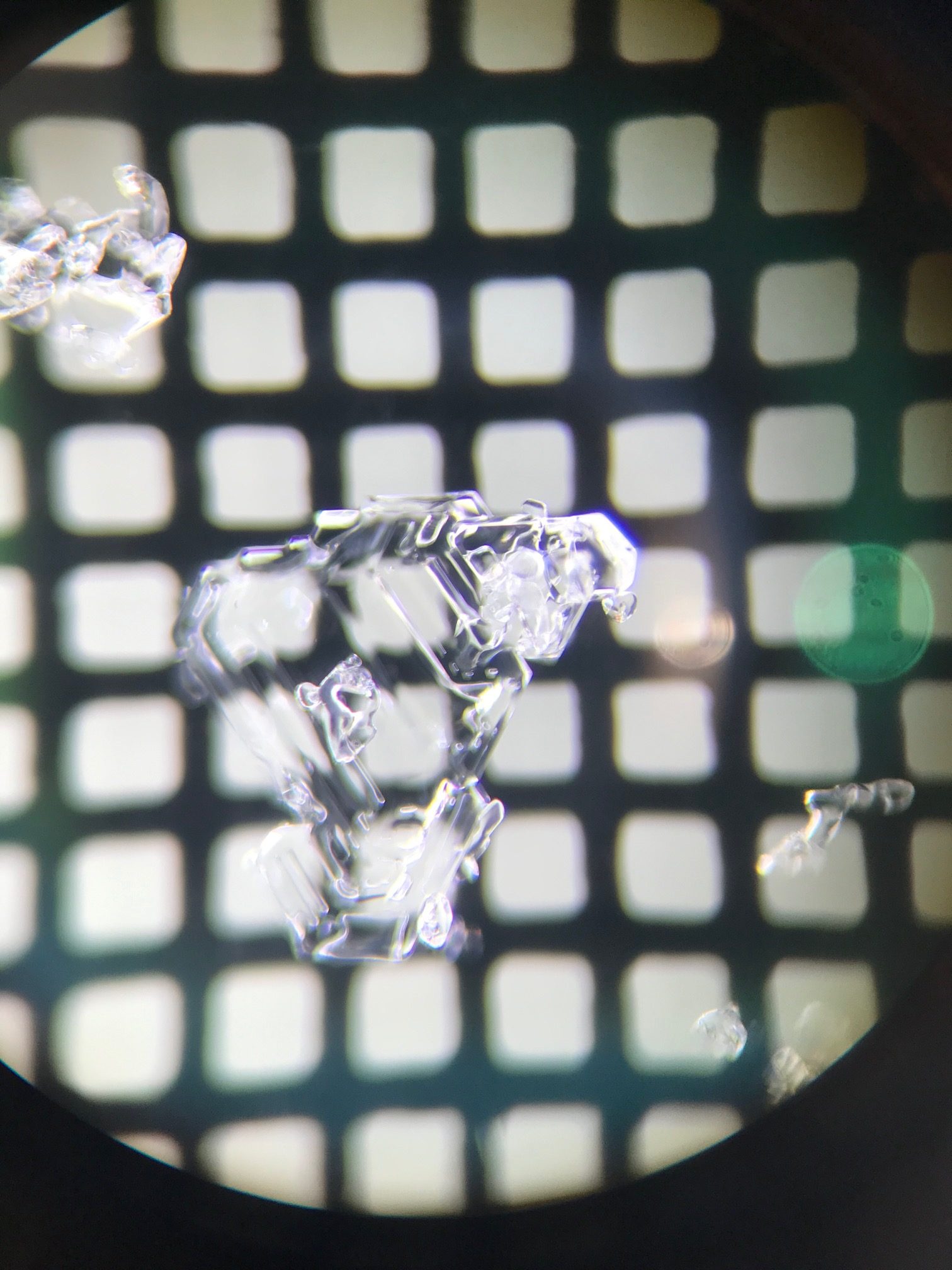
2-3 mm Buried Surface Hoar found around 1′ below the surface on Sunburst. 3.11.20

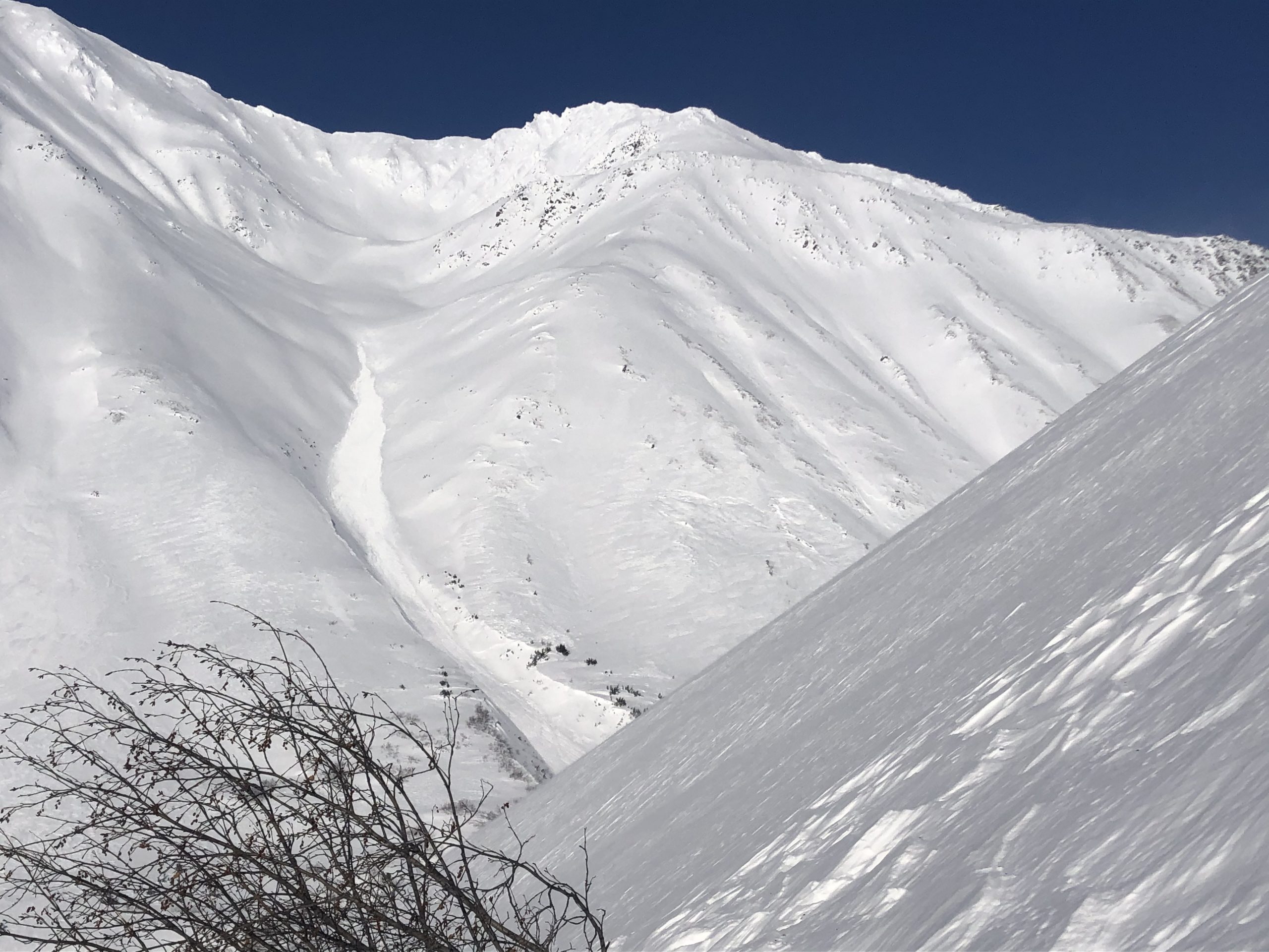
Raggedtop skier triggered slab, thin but propagated approximately 300′ across. This propagation is a characteristic of buried surface hoar. 3.10.20. Photo: Peter Wadsworth.

Cornices:  Avoid travel on cornices and limit exposure underneath them.

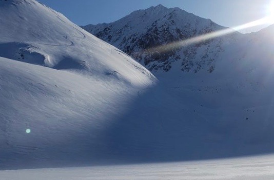
Loose snow avalanches:  In areas that were protected from the wind, sluffs are possible in steep terrain.

Sun effect: The sun is starting to have an impact on surface snow on steep solar aspects.  Be aware of moist surface snow, small roller balls or loose snow avalanches in wind protected spots, especially below steeper rocky areas. As temperatures warm this weekend, it may also make triggering an avalanche on buried weak layers more of an issue.

Weather
Thu, March 12th, 2020

Yesterday: Skies were clear and temperatures were in the single digits and low teens at upper elevations and in the teens to upper 20°Fs at low elevations. Winds were westerly 5-15 mph with gusts into the 20s. Winds recorded at the AKRR MP 43 station were 10-25 mph with gusts into the 40s. Overnight skies remained clear and temperatures ranged from the low teens above 0°F to low teens below 0°F. Westerly winds continued to be gusty through the night.

Today: Skies will be clear with temperatures in the low teens to high 20°Fs. Winds will remain westerly and ease off becoming light by the afternoon. Overnight temperatures will be in the single digits and low teens with calm winds.

Tomorrow: Another day of sunshine is on tap with temperatures climbing into the high 20°Fs to low 30°Fs. Winds will be light and westerly. The clear sunny trend continues over the weekend with mostly calm winds and increasing temperatures.

PRECIPITATION 24-hour data (6am – 6am)

Temp Avg (F) Snow (in) Water (in) Snow Depth (in)
Center Ridge (1880′) 13 0 0 68
Summit Lake (1400′) 7 0 0 31
Alyeska Mid (1700′) 10 0 0 80

RIDGETOP 24-hour data (6am – 6am)

Temp Avg (F) Wind Dir Wind Avg (mph) Wind Gust (mph)
Sunburst (3812′) 3 W 9 25
Seattle Ridge (2400′) 9 W 3 14
Observations
Recent Observations for Turnagain Pass
Date Region Location
03/18/24 Turnagain Observation: Tincan
03/16/24 Turnagain Observation: Seattle Ridge front side
03/16/24 Turnagain Observation: TinCan Backdoor/ Center Ridge/ Sunburst Backdoor
03/16/24 Turnagain Observation: Turnagain Front Side
03/15/24 Turnagain Avalanche: Main Bowl
03/14/24 Turnagain Avalanche: Tincan
03/14/24 Turnagain Avalanche: Sunburst South Face
03/14/24 Turnagain Avalanche: Tincan common
03/14/24 Turnagain Avalanche: Seattle Ridge – avalanches on the front and back side
03/13/24 Turnagain Observation: Turnagain Flats
Riding Areas

The riding areas page has moved. Please click here & update your bookmarks.


Subscribe to Turnagain Pass
Avalanche Forecast by Email

This is a general backcountry avalanche advisory issued for Turnagain Arm with Turnagain Pass as the core advisory area. This advisory does not apply to highways, railroads or operating ski areas.