Turnagain Pass Avalanche Forecast RSS

Archives
ARCHIVED FORECAST - All forecasts expire after 24 hours from the posting date/time.
Issued
Thu, March 10th, 2022 - 7:00AM
Expires
Fri, March 11th, 2022 - 7:00AM
Forecaster
John Sykes
Avalanche risk The Bottom Line

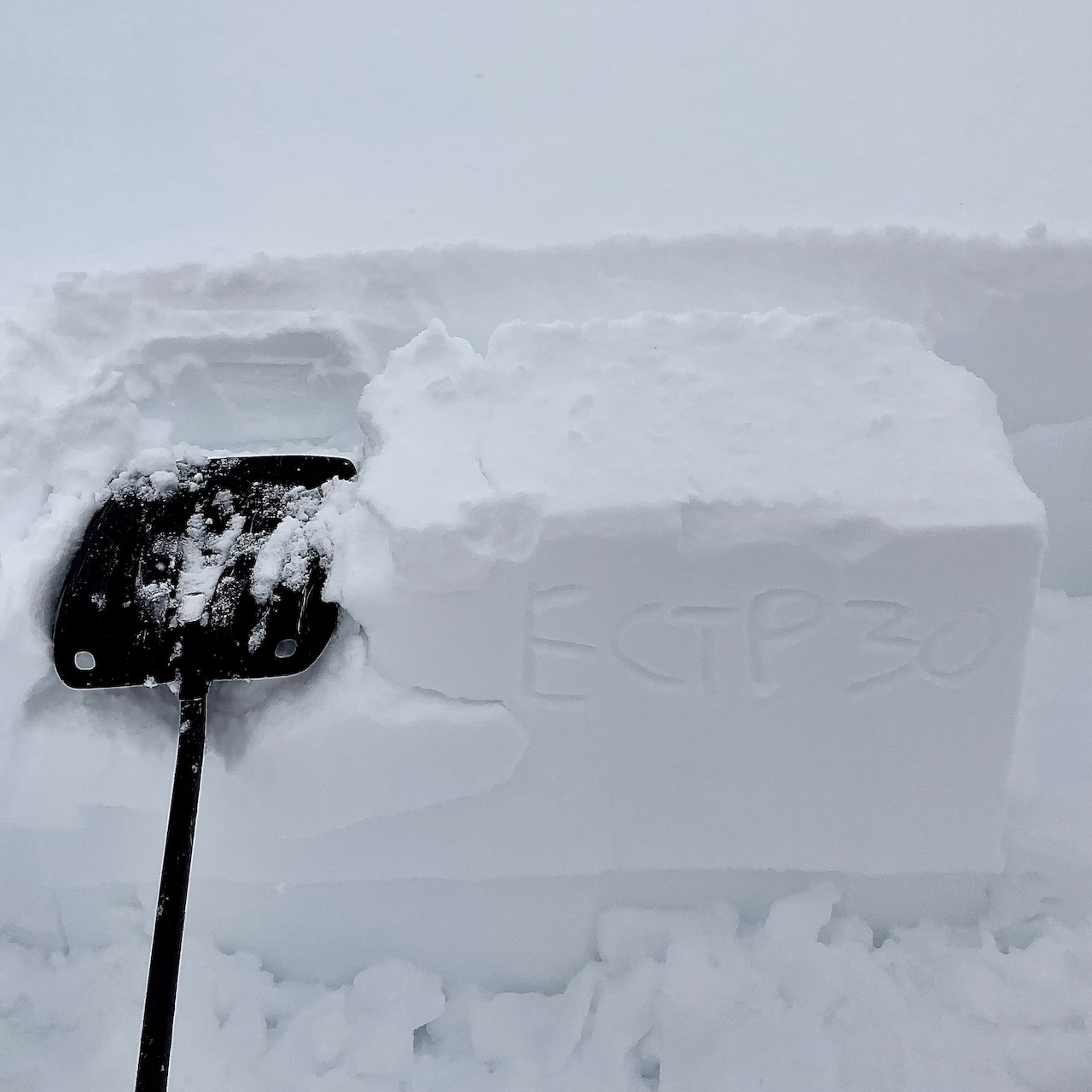
The avalanche danger is CONSIDERABLE above 2500′. Over the past 24 hours 2-6″ of new snow and moderate winds have created fresh wind slabs up to 2′ deep that are likely to be triggered by a person and possible for natural avalanches. Another 2-4″ of snow is expected today with sustained moderate winds which will continue to build wind slabs in upper elevations. The potential also exists for triggering an avalanche on a buried persistent weak layer 1-2′ deep that could create a much larger avalanche.

The avalanche danger is MODERATE below 2500′. Isolated wind slabs up to 2′ deep are still possible for human triggering, as well as the potential for triggering an avalanche on a buried persistent weak layer. If snow line moves up to 500-700′ today then we could see wet loose avalanches in the new snow at lower elevations.

Thanks to our sponsors!
Thu, March 10th, 2022
Alpine
Above 2,500'
Considerable (3)
Avalanche risk
Treeline
1,000'-2,500'
Moderate (2)
Avalanche risk
Below Treeline
Below 1,000'
Moderate (2)
Avalanche risk
Alpine
Above 2,500'
Avalanche risk
Considerable (3)
Treeline
1,000'-2,500'
Avalanche risk
Moderate (2)
Below Treeline
Below 1,000'
Avalanche risk
Moderate (2)
Danger Scale:
No Rating (0)
Low (1)
Moderate (2)
Considerable (3)
High (4)
Extreme (5)
Avalanche Problem 1
  • Wind Slabs
    Wind Slabs
  • Almost Certain
    Very Likely
    Likely
    Possible
    Unlikely
    Likelihood
  • Historic (D4-5)
    Very Large (D3)
    Large (D2)
    Small (D1)
    Size
Wind Slabs
Wind Slab avalanches are the release of a cohesive layer of snow (a slab) formed by the wind. Wind typically transports snow from the upwind sides of terrain features and deposits snow on the downwind side. Wind slabs are often smooth and rounded and sometimes sound hollow, and can range from soft to hard. Wind slabs that form over a persistent weak layer (surface hoar, depth hoar, or near-surface facets) may be termed Persistent Slabs or may develop into Persistent Slabs.

Likelihood of Avalanches
Terms such as "unlikely", "likely", and "certain" are used to define the scale, with the chance of triggering or observing avalanches increasing as we move up the scale. For our purposes, "Unlikely" means that few avalanches could be triggered in avalanche terrain and natural avalanches are not expected. "Certain" means that humans will be able to trigger avalanches on many slopes, and natural avalanches are expected.

Size of Avalanches
Avalanche size is defined by the largest potential avalanche, or expected range of sizes related to the problem in question. Assigned size is a qualitative estimate based on the destructive classification system and requires specialists to estimate the harm avalanches may cause to hypothetical objects located in the avalanche track (AAA 2016, CAA 2014). Under this schema, "Small" avalanches are not large enough to bury humans and are relatively harmless unless they carry people over cliffs or through trees or rocks. Moving up the scale, avalanches become "Large" enough to bury, injure, or kill people. "Very Large" avalanches may bury or destroy vehicles or houses, and "Historic" avalanches are massive events capable of altering the landscape.

Signal Word Size (D scale) Simple Descriptor
Small 1 Unlikely to bury a person
Large 2 Can bury a person
Very Large 3 Can destroy a house
Historic 4 & 5 Can destroy part or all of a village
More info at Avalanche.org

The mountains received a refresh of new snow over the past 24 hours, with anywhere from 2-6″ falling across the forecast area. Another 2-4″ of new snow is expected today with snow line moving up to 500-700′ during the day. Snow totals on the higher end of those ranges are expected in more coastal areas like Portage and Placer, with Girdwood in the middle, and Turnagain Pass on the lower end. Moderate winds in the 15-30 mph range will accompany the snowfall and transport the new snow into fresh wind slabs up to 2′ deep that will be likely for human triggering and possible for natural avalanches. Wind slabs will be most likely at upper elevations along ridgelines, cross loaded gullies, and convex roll overs. As always, keep an eye out for active wind loading, shooting cracks, and hollow feeling snow to identify locations with potential wind slabs.

Reports from yesterday at Turnagain Pass indicate that the new snow was adhering to the old surface well in the treeline elevation band with isolated pockets of wind slab that were producing shooting cracks (ob here). Visibility was too poor to see any avalanche activity in the alpine, but we expect that conditions were more touchy at upper elevations where the temperatures were colder and winds were stronger. The potential for wind loading to initiate an avalanche on a deeper weak layer exists with persistent weak layers buried in the upper snowpack across the region (see problem 2).

Shooting crack on cornice feature near treeline on Tincan. Photo from Andy Moderow 3.9.22

Avalanche Problem 2
  • Persistent Slabs
    Persistent Slabs
  • Almost Certain
    Very Likely
    Likely
    Possible
    Unlikely
    Likelihood
  • Historic (D4-5)
    Very Large (D3)
    Large (D2)
    Small (D1)
    Size
Persistent Slabs
Persistent Slab avalanches are the release of a cohesive layer of snow (a slab) in the middle to upper snowpack, when the bond to an underlying persistent weak layer breaks. Persistent layers include: surface hoar, depth hoar, near-surface facets, or faceted snow. Persistent weak layers can continue to produce avalanches for days, weeks or even months, making them especially dangerous and tricky. As additional snow and wind events build a thicker slab on top of the persistent weak layer, this avalanche problem may develop into a Deep Persistent Slab.

Likelihood of Avalanches
Terms such as "unlikely", "likely", and "certain" are used to define the scale, with the chance of triggering or observing avalanches increasing as we move up the scale. For our purposes, "Unlikely" means that few avalanches could be triggered in avalanche terrain and natural avalanches are not expected. "Certain" means that humans will be able to trigger avalanches on many slopes, and natural avalanches are expected.

Size of Avalanches
Avalanche size is defined by the largest potential avalanche, or expected range of sizes related to the problem in question. Assigned size is a qualitative estimate based on the destructive classification system and requires specialists to estimate the harm avalanches may cause to hypothetical objects located in the avalanche track (AAA 2016, CAA 2014). Under this schema, "Small" avalanches are not large enough to bury humans and are relatively harmless unless they carry people over cliffs or through trees or rocks. Moving up the scale, avalanches become "Large" enough to bury, injure, or kill people. "Very Large" avalanches may bury or destroy vehicles or houses, and "Historic" avalanches are massive events capable of altering the landscape.

Signal Word Size (D scale) Simple Descriptor
Small 1 Unlikely to bury a person
Large 2 Can bury a person
Very Large 3 Can destroy a house
Historic 4 & 5 Can destroy part or all of a village
More info at Avalanche.org

In the upper 1-2′ of the snowpack a few different persistent weak layers have been observed across the forecast area, including buried surface hoar and near surface facets. These weak layers can cause avalanches to release on lower angle slopes than normal, propagate more widely than normal, and are not always triggered by the first person to travel on a slope. The 3.2 buried surface hoar does not necessarily exist everywhere, so it is recommended to use a snowpit to check weather it is a concerning weak layer in the area you are travelling.

Yesterday, an observer on Tincan found the 3.2 BSH in 3 out of 4 locations he checked, but only had propagating extended column test results in one location. The pit that did propagate had a thicker and stronger slab on top of the surface hoar which was likely helping to drive propagation. As we start to get a bigger load of new snow on top of these buried persistent weak layers their potential to create avalanches could increase. We recommend careful evaluation of the snowpack before entering avalanche terrain.

Extended column test with propagation on the 30th tap which failed on a layer of buried surface hoar down 18″ from the surface. Photo from Andy Moderow 3.9.22

Very low visibility in Turnagain Pass yesterday. Photo from Andy Moderow 3.9.22

Weather
Thu, March 10th, 2022

Yesterday: Light snow and low clouds with winds in the 10-20 mph range and gusts of 20-35 mph. Snow accumulation of around 2″ during the day yesterday with snow line down to sea level. Temperatures were remarkably consistent, in the 10-20 F range at ridgetops and 25-35 F at road level.

Today: Another 1-4″ of new snow expected, with more coastal areas like Portage and Placer on the higher side of that range. Wind speeds will be in the 15-30 mph range at ridgetops. Temperatures will increase slightly, in the 30s at lower elevations and 20s at upper elevations. Snow line should rise to about 500-700′ this afternoon.

Tomorrow: Light snowfall is expected to continue overnight tonight with another 2-6″ of snow across the region. Wind speeds should decrease on Friday and remain light over the weekend. Temperatures will also remain steady over the next 24 to 48 hours before dropping slightly on Saturday.

PRECIPITATION 24-hour data (6am – 6am)

Temp Avg (F) Snow (in) Water (in) Snow Depth (in)
Center Ridge (1880′) 29 3 0.3 95
Summit Lake (1400′) 29 1 0.1 42
Alyeska Mid (1700′) 28 6 0.6 NA

RIDGETOP 24-hour data (6am – 6am)

Temp Avg (F) Wind Dir Wind Avg (mph) Wind Gust (mph)
Sunburst (3812′) 18 ENE 16 37
Seattle Ridge (2400′) 22 SE 16 29
Observations
Recent Observations for Turnagain Pass
Date Region Location
05/22/23 Turnagain Avalanche: Tincan
05/12/23 Turnagain Avalanche: Tincan, Sunburst, Magnum, Cornbiscuit
05/07/23 Turnagain Observation: Tincan – Bear Tracks
05/05/23 Turnagain Observation: Seattle Ridge
05/02/23 Turnagain Observation: Cornbiscuit
05/02/23 Turnagain Observation: Seward Hwy Turnagain Pass
04/30/23 Turnagain Observation: Magnum
04/29/23 Turnagain Observation: Tincan
04/28/23 Turnagain Avalanche: Taylor Pass/Pastoral
04/28/23 Turnagain Avalanche: Tincan
Riding Areas
Updated Mon, May 15th, 2023

Status of riding areas across the Chugach NF is managed by the Glacier and Seward Ranger Districts, not avalanche center staff. Riding area information is posted as a public service to our users and updated based on snow depth and snow density to prevent resource damage at trailhead locations. Riding area questions contact: mailroom_r10_chugach@fs.fed.us

Area Status Weather & Riding Conditions
Glacier District
Johnson Pass
Closed
Closed May 15.
Placer River
Closed
Closed May 15.
Skookum Drainage
Closed
Will close to motorized use on April 1, 2023 per the National Forest Plan.
Turnagain Pass
Open
Chugach NF staff will be assessing daily after May 15th. Please keep machines on the snow and avoid brown spots to keep this area open as long as possible.
Twentymile
Closed
Scheduled closure May 1.
Seward District
Carter Lake
Closed
Scheduled closure May 1.
Lost Lake Trail
Closed
Scheduled closure May 1.
Primrose Trail
Closed
Scheduled closure May 1.
Resurrection Pass Trail
Closed
Closed to motorized use for the 2022/23 winter season per Forest Plan. Open next season.
Snug Harbor
Closed
Extended opening until May 15.
South Fork Snow River Corridor
Closed
Scheduled closure May 1.
Summit Lake
Closed
Scheduled closure May 1.

Subscribe to Turnagain Pass
Avalanche Forecast by Email

This is a general backcountry avalanche advisory issued for Turnagain Arm with Turnagain Pass as the core advisory area. This advisory does not apply to highways, railroads or operating ski areas.