Turnagain Pass RSS

Archives
ARCHIVED - Forecasts expire after 24 hours.
Issued
Thu, March 9th, 2023 - 7:00AM
Expires
Fri, March 10th, 2023 - 7:00AM
Forecaster
John Sykes
Avalanche risk The Bottom Line

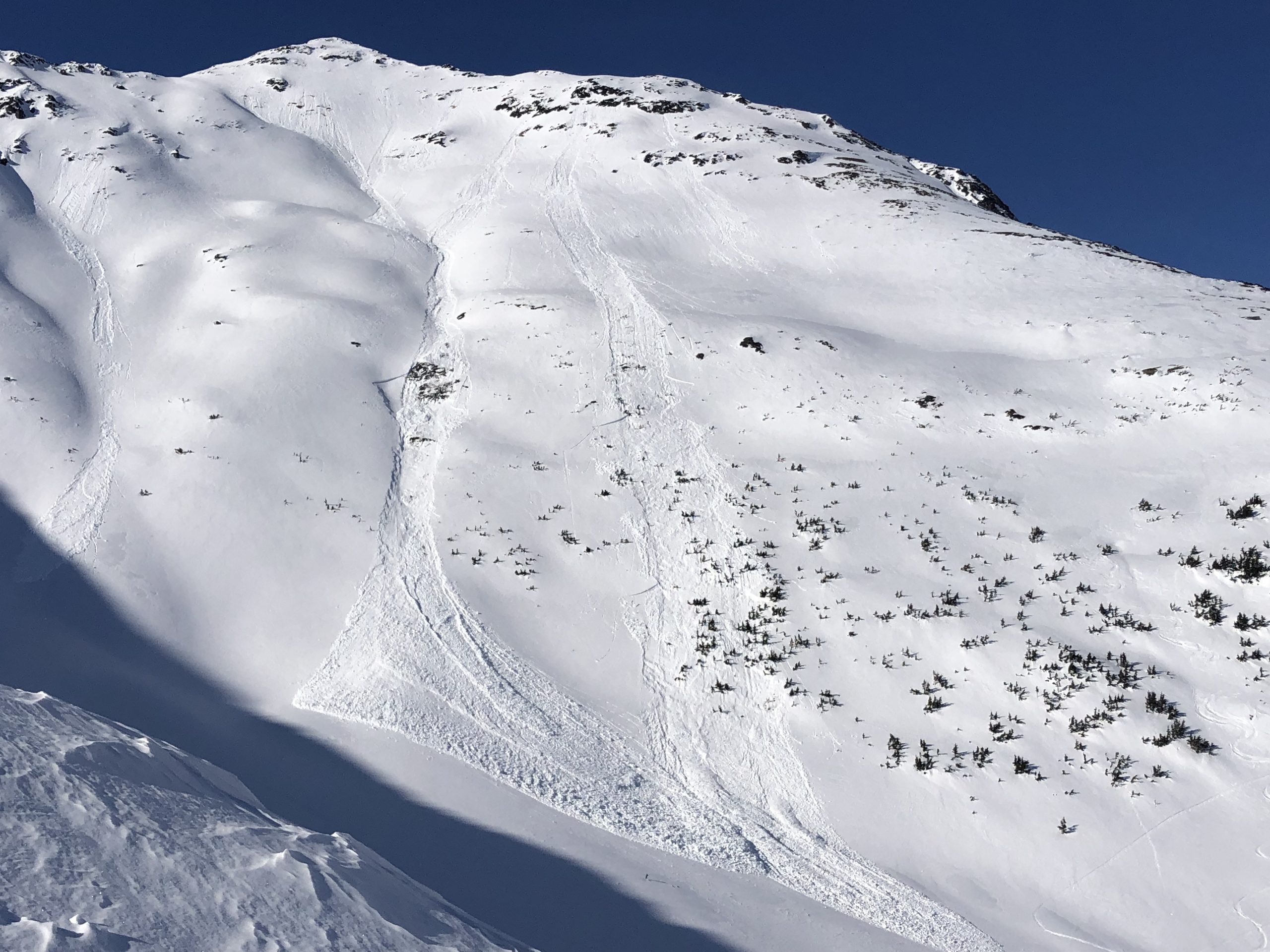
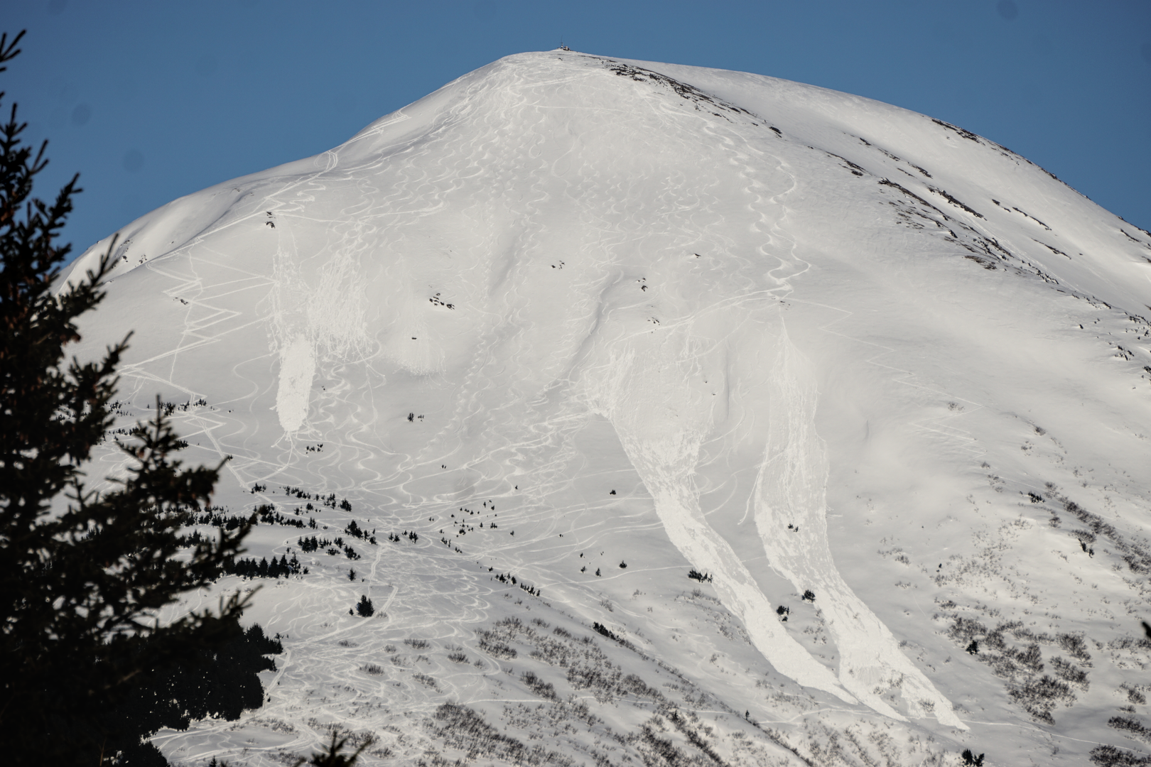
The avalanche danger is MODERATE above 2500′. NW winds are picking up this morning which could make natural or human triggered avalanches up to 1′ deep possible at upper elevations. We expect these to be isolated to higher elevation ridgelines and areas that are exposed to gap winds like along Turnagain Arm. On the southern end of the forecast zone near Johnson Pass the snowpack is generally weaker and triggering an avalanche on a deeper weak layer is possible. Below 2500′ the avalanche danger is LOW. 

SUMMIT LAKE / LOST LAKE / SNUG HARBOR: NW winds picking up this morning will increase avalanche danger in areas with any soft snow remaining that could be transported by the wind. In areas with a thinner and weaker overall snowpack like Summit Lake, this could make deeper weak layer more active again.


Special Announcements

Turnagain Pass Avalanche Awareness Day – Mar 18, 2023:  Mark your calendars and swing by on your way to or from your backcountry ride or ski!! Test your beacon skills, chow down on hot dogs, and bring your questions for CNFAC forecasters. The Alaska Avalanche School will be there along with a chance to demo snowmachines from Alaska Mining and Diving Supply and Anchorage Yamaha and Polaris. More details HERE!

Thu, March 9th, 2023
Alpine
Above 2,500'
2 - Moderate
Avalanche risk
Treeline
1,000'-2,500'
1 - Low
Avalanche risk
Below Treeline
Below 1,000'
1 - Low
Avalanche risk
0 - No Rating
1 - Low
2 - Moderate
3 - Considerable
4 - High
5 - Extreme
Avalanche risk Avalanche risk Avalanche risk Avalanche risk Avalanche risk
Travel Advice Generally safe avalanche conditions. Watch for unstable snow on isolated terrain features. Heightened avalanche conditions on specific terrain features. Evaluate snow and terrain carefully; identify features of concern. Dangerous avalanche conditions. Careful snowpack evaluation, cautious route-finding, and conservative decision-making essential. Very dangerous avalanche conditions. Travel in avalanche terrain not recommended. Extraordinarily dangerous avalanche conditions. Avoid all avalanche terrain.
Likelihood of Avalanches Natural and human-triggered avalanches unlikely. Natural avalanches unlikely; human-triggered avalanches possible. Natural avalanches possible; human-triggered avalanches likely. Natural avalanches likely; human-triggered avalanches very likely. Natural and human-triggered avalanches certain.
Avalanche Size and Distribution Small avalanches in isolated areas or extreme terrain. Small avalanches in specific areas; or large avalanches in isolated areas. Small avalanches in many areas; or large avalanches in specific areas; or very large avalanches in isolated areas. Large avalanches in many areas; or very large avalanches in specific areas. Very large avalanches in many areas.
Recent Avalanches

There were several fresh piles of wet loose avalanche debris observed yesterday that occurred on either Mar 7th or 8th. These were isolated to steep southerly slopes and examples of both natural and human triggered avalanches were observed. The last larger slab avalanche that we know of was skier triggered on Monday in the Johnson Pass area on the far southern end of the forecast zone (see Wednesday’s forecast for a good photo).

Two fairly large wet loose avalanches in the Crow Creek area that released naturally from the rocks and triggered small pockets of deeper slab avalanches midway down the slope. Photo 3.8.23 from Allen Dahl.

Several skier triggered wet loose avalanches that pickup up steam and left some sizable debris piles on the SW shoulder of Max’s in Girdwood. Photo 3.8.23

Avalanche Problem 1
  • Wind Slabs
    Wind Slabs
  • Aspect/Elevation
  • Certain
    Very Likely
    Likely
    Possible
    Unlikely
    Likelihood
  • Historic (D4-5)
    Very Large (D3)
    Large (D2)
    Small (D1)
    Size
Wind Slabs
Wind Slab avalanches are the release of a cohesive layer of snow (a slab) formed by the wind. Wind typically transports snow from the upwind sides of terrain features and deposits snow on the downwind side. Wind slabs are often smooth and rounded and sometimes sound hollow, and can range from soft to hard. Wind slabs that form over a persistent weak layer (surface hoar, depth hoar, or near-surface facets) may be termed Persistent Slabs or may develop into Persistent Slabs.

Aspect/Elevation of the Avalanche Problem
Specialists develop a graphic representation of the potential distribution of a particular avalanche problem across the topography. This aspect/elevation rose is used to indicate where the particular avalanche problem is thought to exist on all elevation aspects. Areas where the avalanche problem is thought to exist are colored grey, and it is less likely to be encountered in areas colored white.

Likelihood of Avalanches
Terms such as "unlikely", "likely", and "certain" are used to define the scale, with the chance of triggering or observing avalanches increasing as we move up the scale. For our purposes, "Unlikely" means that few avalanches could be triggered in avalanche terrain and natural avalanches are not expected. "Certain" means that humans will be able to trigger avalanches on many slopes, and natural avalanches are expected.

Size of Avalanches
Avalanche size is defined by the largest potential avalanche, or expected range of sizes related to the problem in question. Assigned size is a qualitative estimate based on the destructive classification system and requires specialists to estimate the harm avalanches may cause to hypothetical objects located in the avalanche track (AAA 2016, CAA 2014). Under this schema, "Small" avalanches are not large enough to bury humans and are relatively harmless unless they carry people over cliffs or through trees or rocks. Moving up the scale, avalanches become "Large" enough to bury, injure, or kill people. "Very Large" avalanches may bury or destroy vehicles or houses, and "Historic" avalanches are massive events capable of altering the landscape.

Signal Word Size (D scale) Simple Descriptor
Small 1 Unlikely to bury a person
Large 2 Can bury a person
Very Large 3 Can destroy a house
Historic 4 & 5 Can destroy part or all of a village
More info at Avalanche.org

The temperatures dipped back below freezing last night after three days of a strong temperature inversion which created some premature spring like wet snow conditions. Today the temperatures are expected to remain below freezing throughout the day at upper elevations which should slow down the onslaught of wet loose avalanches that have been releasing both naturally and from human triggers the past few days. Wet loose avalanches could still be possible on steep south facing terrain in the afternoon but we do not expect them to be as large or widespread as they have been the last few days.

We are currently on the brink of being at low danger at all elevations, but just as the warm temperatures departed a new round of NW winds picked up overnight. Thanks to the prior round of NW winds that impacted the area last weekend the snow surface is already largely wind affected which should limit the amount of snow available for transport today. However, with weather stations already reporting gusts of 30+ mph this morning it is important to have wind slabs on our radar today at upper elevations. Natural and human triggered avalanches up to 1′ deep are possible in areas that are receiving active wind loading. This wind direction commonly has the greatest impact in areas along Turnagain Arm and on upper elevation ridgelines. To identify features with fresh wind slabs you can use small test slopes to check for shooting cracks and look for areas where the snow is visibly being transported by the wind.

Cornice fall is also possible with the combination of active wind loading and sunny skies. Be aware of any large cornices overhead and try to minimize time underneath them, especially if they are being wind loaded or baked in the sun.

Glide cracks have been opening up over the past several weeks. These things have a mind of their own and can release under any conditions, so it is important to be aware of any glide cracks overhead and try to minimize time spent underneath them.

Snow surfaces on shady aspects are already pretty wind affected, so today’s winds might not have as much loose snow to transport into fresh wind slabs. Photo 3.8.23

Additional Concern
  • Persistent Slabs
    Persistent Slabs
Persistent Slabs
Persistent Slab avalanches are the release of a cohesive layer of snow (a slab) in the middle to upper snowpack, when the bond to an underlying persistent weak layer breaks. Persistent layers include: surface hoar, depth hoar, near-surface facets, or faceted snow. Persistent weak layers can continue to produce avalanches for days, weeks or even months, making them especially dangerous and tricky. As additional snow and wind events build a thicker slab on top of the persistent weak layer, this avalanche problem may develop into a Deep Persistent Slab.
More info at Avalanche.org

Areas of the forecast zone with a thinner snowpack, like near Johnson Pass, are still harboring persistent weak layers that could cause a larger avalanche. The last know avalanche on one of these layers was in the Bench Peak area and was skier triggered on Monday. We also have received reports of whumphs and seen some unstable snowpack structure from test pits on Pete’s N in the past week. This area typically gets a lot less snow than most of the forecast zone which can make persistent weak layers last longer and be more easily triggered by the weight of a skier or rider. Extra caution and careful evaluation of the snowpack is recommended if you are travelling in these areas.

Weather
Thu, March 9th, 2023

Yesterday: Clear skies and unseasonably warm temperatures reaching 40-45 F at mid and upper elevations for the third day in a row as a temperature inversion has been lingering in the area. Temperatures finally dipped back below freezing around midnight on Wednesday as the inversion starts to dissipate. Winds were calm to light during the day but shifted to NW overnight and increased slightly.

Today: Temperatures have dipped down below freezing overnight and are expected to remain in the 20s F at upper elevations today. Winds out of the NW picked up overnight and should increase to 15-20 mph with gusts up to 30-40 mph today. Clear skies are expected again today with no snowfall expected over the next few days.

Tomorrow: On Friday the winds are expected to shift to the NE and wind speeds should remain in the 15-25 mph range with stronger gusts. Clear skies are expected to remain through Saturday with no new snowfall expected. Temperatures at upper elevations should be in the teens to low 20s F.

PRECIPITATION 24-hour data (6am – 6am)

Temp Avg (F) Snow (in) Water (in) Snow Depth (in)
Center Ridge (1880′) 36 0 0 65
Summit Lake (1400′) 30 0 0 38
Alyeska Mid (1700′) 35 0 0 66
Bear Valley – Portage (132′) 27 0 0

RIDGETOP 24-hour data (6am – 6am)

Temp Avg (F) Wind Dir Wind Avg (mph) Wind Gust (mph)
Sunburst (3812′) 36 W 7 31
Seattle Ridge (2400′) 38 NW 4 24
Observations
Recent Observations for Turnagain Pass
Date Region Location
04/16/24 Turnagain Observation: Cornbiscuit
04/15/24 Turnagain Observation: Taylor Pass
04/15/24 Turnagain Observation: Seward Highway – Tern Lake to Portage
04/14/24 Turnagain Observation: Sunburst
04/14/24 Turnagain Observation: Turnagain Pass Snomo
04/13/24 Turnagain Observation: Spokane Creek
04/11/24 Turnagain Observation: Tincan
04/10/24 Turnagain Avalanche: Seattle Ridge
04/10/24 Turnagain Observation: Cornbiscuit South Face
04/10/24 Turnagain Avalanche: Tincan
Riding Areas

The riding areas page has moved. Please click here & update your bookmarks.


Subscribe to Turnagain Pass
Avalanche Forecast by Email

This is a general backcountry avalanche advisory issued for Turnagain Arm with Turnagain Pass as the core advisory area. This advisory does not apply to highways, railroads or operating ski areas.