Turnagain Pass Avalanche Forecast
|
![]() ![]() |
A MODERATE avalanche danger remains at all elevations. An increase in east winds forecast today should blow a few inches of new snow and any old soft snow into small shallow wind slabs. These will be possible to trigger on any slope with new wind deposited snow. In areas out of the winds at all elevations, triggering a slab avalanche 1-2′ deep is possible due to buried weak layers.
PORTAGE/PLACER VALLEYS: Small natural wind slab avalanches and cornice falls will be possible, as this is where most the new snow is falling.
Signal Word | Size (D scale) | Simple Descriptor |
Small | 1 | Unlikely to bury a person |
Large | 2 | Can bury a person |
Very Large | 3 | Can destroy a house |
Historic | 4 & 5 | Can destroy part or all of a village |
The winds will be at it once again. If the weather models are right, by noon today ridgetops will be seeing east winds averaging 30-40mph with stronger gusts. That’s pretty good wind for the small weather system skirting us by to the south… Unfortunately, the wind will only be accompanied by 2-4″ of new snow, at best. If we add this to the 1-3″ of snow from last night, the wind has a total of 3-7″ to work with. Add to that limited amounts of old snow still available to blow around, and we can expect any fresh slab to be on the shallower side, 6-10″ thick or so. Areas that often see more snow, such as Portage and Placer Valley, could have larger slabs up to a foot thick form today.
With poor visibility, travel into the higher elevations where most the action is will likely be a bit difficult. However, we could see some wind at the mid elevations as well. So keeping a close eye out for active wind loading will be key. And as always, watch for cracks that shoot out from you and stiff hollow feeling snow over softer snow. There could be some linger old wind slabs lurking in areas out of the winds as well.
Signal Word | Size (D scale) | Simple Descriptor |
Small | 1 | Unlikely to bury a person |
Large | 2 | Can bury a person |
Very Large | 3 | Can destroy a house |
Historic | 4 & 5 | Can destroy part or all of a village |
Buried in the top two feet of the snowpack are a couple layers of buried surface hoar and facets. The most recent avalanches on these layers were three days ago on the steep SW face of Eddies Ridge. At elevations below 2,000′ a crust sits under the weak layers and was producing avalanches last week. We know these layers are present in most areas, but they are not reactive everywhere, which makes it tricky. The fact we are still seeing avalanches however is not something to ignore.
A few things to consider:
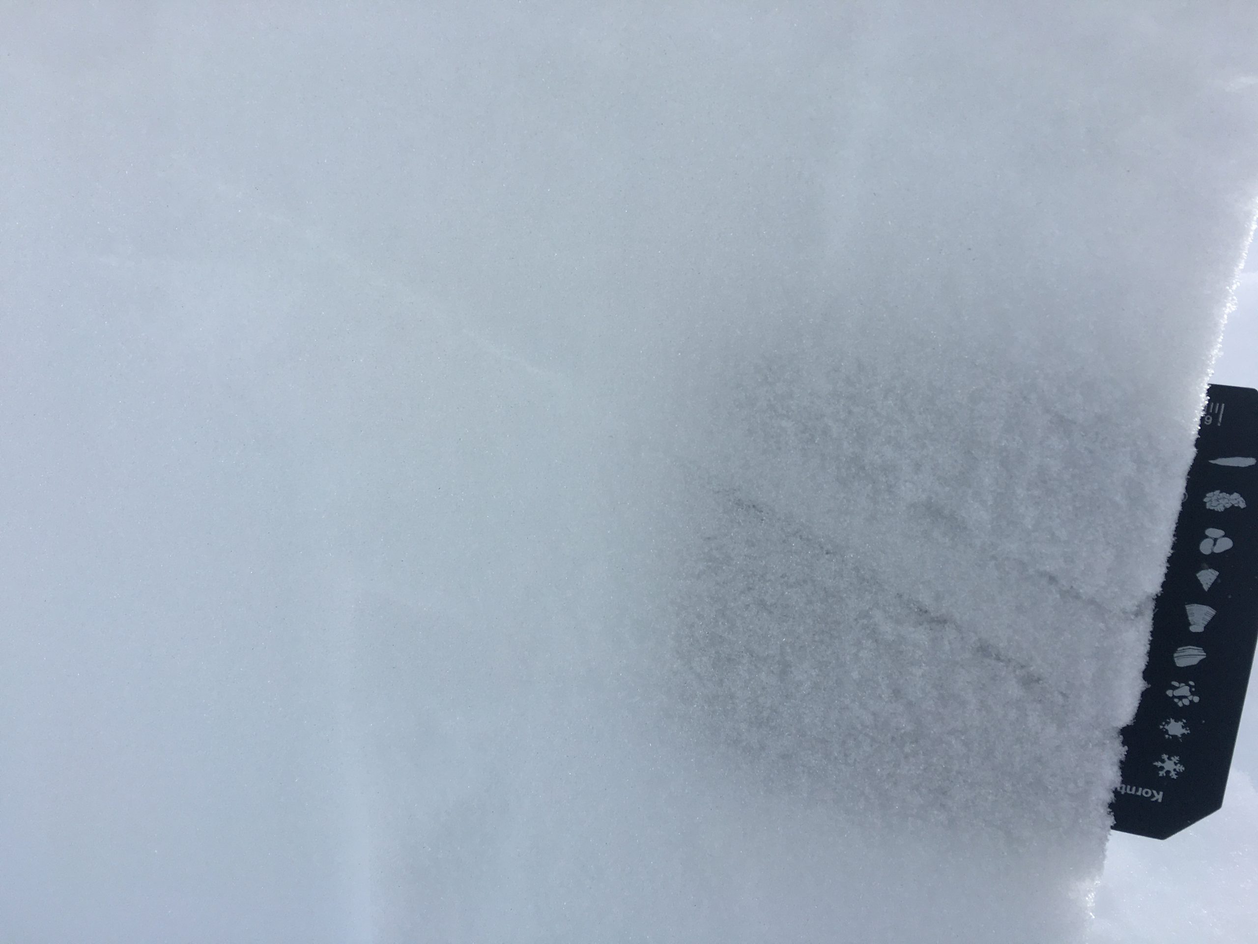
Andrew found this layer of buried surface hoar (the thin gray line) on Magnum two days ago. It sat just over a foot below the surface. 2.22.21.
Yesterday: Mostly overcast skies and an east breeze were over the region yesterday. Ridgetop winds averaged 10-20mph with gusts in the 20’s. Temperatures climbed from the single digits to the 20’s yesterday morning where they have remained. Light snowfall began overnight with a few inches accumulating in upper Girdwood and Portage Valleys while only an inch or two has fallen at Turnagain Pass.
Today: Cloudy skies with light snowfall should continue through today as a low pressure skirts just to our south. Only 1-3″ of accumulation is expected of very low density snow. Snow should taper off tonight. However, ridgetop winds are forecast to increase into the 30-40mph range before also calming down tonight. Temperatures will stay civil, in the 20’s in the mountains and ~32F at sea level.
Tomorrow: Mostly clear skies are expected for tomorrow as the low exists and we see a return to the northwest winds. Ridgetop averages look to average in the 15-25mph range at this time, which isn’t too bad. Temperatures should cool to the teens. A chance for more snow is slated for the weekend. Stay tuned.
PRECIPITATION 24-hour data (6am – 6am)
Temp Avg (F) | Snow (in) | Water (in) | Snow Depth (in) | |
---|---|---|---|---|
Center Ridge (1880′) | 22 | 1 | 0.1 | 113 |
Summit Lake (1400′) | 20 | 1 | 0.1 | 44 |
Alyeska Mid (1700′) | 20 | 2 | 0.1 | 113 |
RIDGETOP 24-hour data (6am – 6am)
Temp Avg (F) | Wind Dir | Wind Avg (mph) | Wind Gust (mph) | |
---|---|---|---|---|
Sunburst (3812′) | 14 | E | 14 | 35 |
Seattle Ridge (2400′) | 16 | SE | 12 | 22 |
Date | Region | Location | Observer |
---|---|---|---|
01/31/23 | Turnagain | Observation: Johnson Pass area | Megan Guinn / W Wagner Forecaster |
01/29/23 | Turnagain | Observation: Tincan Backdoor | AAS-Level 1 1/27-1/30 |
01/28/23 | Turnagain | Observation: Sunburst | Brooke Edwards |
01/28/23 | Turnagain | Avalanche: Seattle Ridge | W Wagner |
01/28/23 | Turnagain | Observation: Tincan Common | Tony Naciuk |
01/27/23 | Turnagain | Observation: Sunburst | John Sykes |
01/27/23 | Turnagain | Avalanche: Lynx Creek | Megan Guinn / W Wagner |
01/25/23 | Turnagain | Observation: Cornbiscuit | John Sykes Forecaster |
01/22/23 | Turnagain | Avalanche: Tincan | Schauer/ Guinn |
01/21/23 | Turnagain | Avalanche: Seattle Ridge | Elias Holt |
Status of riding areas across the Chugach NF is managed by the Glacier and Seward Ranger Districts, not avalanche center staff. Riding area information is posted as a public service to our users and updated based on snow depth and snow density to prevent resource damage at trailhead locations. Riding area questions contact: mailroom_r10_chugach@fs.fed.us
Area | Status | Weather & Riding Conditions |
---|---|---|
Glacier District |
Subscribe to Turnagain Pass
Avalanche Forecast by Email
This is a general backcountry avalanche advisory issued for Turnagain Arm with Turnagain Pass as the core advisory area. This advisory does not apply to highways, railroads or operating ski areas.