Turnagain Pass RSS

Archives
ARCHIVED - Forecasts expire after 24 hours.
Issued
Tue, February 23rd, 2021 - 7:00AM
Expires
Wed, February 24th, 2021 - 7:00AM
Forecaster
Andrew Schauer
Avalanche risk The Bottom Line

Today’s avalanche danger is MODERATE as shifting winds continue to redistribute snow, making it possible to trigger a wind slab avalanche up to a foot deep. Below the surface, there are also two different weak layers of snow 1-2’ deep that are still capable of producing avalanches large enough to bury a person. Travel in avalanche terrain today will mean paying careful attention to recent wind loading on all aspects of the compass, and considering the consequences of getting caught in an avalanche failing deeper in the snowpack.

Tue, February 23rd, 2021
Alpine
Above 2,500'
2 - Moderate
Avalanche risk
Treeline
1,000'-2,500'
2 - Moderate
Avalanche risk
Below Treeline
Below 1,000'
2 - Moderate
Avalanche risk
0 - No Rating
1 - Low
2 - Moderate
3 - Considerable
4 - High
5 - Extreme
Avalanche risk Avalanche risk Avalanche risk Avalanche risk Avalanche risk
Travel Advice Generally safe avalanche conditions. Watch for unstable snow on isolated terrain features. Heightened avalanche conditions on specific terrain features. Evaluate snow and terrain carefully; identify features of concern. Dangerous avalanche conditions. Careful snowpack evaluation, cautious route-finding, and conservative decision-making essential. Very dangerous avalanche conditions. Travel in avalanche terrain not recommended. Extraordinarily dangerous avalanche conditions. Avoid all avalanche terrain.
Likelihood of Avalanches Natural and human-triggered avalanches unlikely. Natural avalanches unlikely; human-triggered avalanches possible. Natural avalanches possible; human-triggered avalanches likely. Natural avalanches likely; human-triggered avalanches very likely. Natural and human-triggered avalanches certain.
Avalanche Size and Distribution Small avalanches in isolated areas or extreme terrain. Small avalanches in specific areas; or large avalanches in isolated areas. Small avalanches in many areas; or large avalanches in specific areas; or very large avalanches in isolated areas. Large avalanches in many areas; or very large avalanches in specific areas. Very large avalanches in many areas.
Recent Avalanches

Eddie’s: Skiers reported one natural avalanche triggered on Sunday by a refrigerator-sized chunk of cornice falling onto the slope, and another skier-triggered avalanche on a similar piece of terrain. They occurred on the steep south-facing terrain behind Eddie’s. Nobody was caught in either slide. Both avalanches were about 10” deep and around 50-100’ wide, failing on a layer of buried surface hoar. More details here.


Looking up at the start zone of one of the avalanches in the Eddie’s spines. Photo: Peter Ostroski. 02.21.2021


Avalanche Problem 1
  • Wind Slabs
    Wind Slabs
  • Certain
    Very Likely
    Likely
    Possible
    Unlikely
    Likelihood
  • Historic (D4-5)
    Very Large (D3)
    Large (D2)
    Small (D1)
    Size
Wind Slabs
Wind Slab avalanches are the release of a cohesive layer of snow (a slab) formed by the wind. Wind typically transports snow from the upwind sides of terrain features and deposits snow on the downwind side. Wind slabs are often smooth and rounded and sometimes sound hollow, and can range from soft to hard. Wind slabs that form over a persistent weak layer (surface hoar, depth hoar, or near-surface facets) may be termed Persistent Slabs or may develop into Persistent Slabs.

Likelihood of Avalanches
Terms such as "unlikely", "likely", and "certain" are used to define the scale, with the chance of triggering or observing avalanches increasing as we move up the scale. For our purposes, "Unlikely" means that few avalanches could be triggered in avalanche terrain and natural avalanches are not expected. "Certain" means that humans will be able to trigger avalanches on many slopes, and natural avalanches are expected.

Size of Avalanches
Avalanche size is defined by the largest potential avalanche, or expected range of sizes related to the problem in question. Assigned size is a qualitative estimate based on the destructive classification system and requires specialists to estimate the harm avalanches may cause to hypothetical objects located in the avalanche track (AAA 2016, CAA 2014). Under this schema, "Small" avalanches are not large enough to bury humans and are relatively harmless unless they carry people over cliffs or through trees or rocks. Moving up the scale, avalanches become "Large" enough to bury, injure, or kill people. "Very Large" avalanches may bury or destroy vehicles or houses, and "Historic" avalanches are massive events capable of altering the landscape.

Signal Word Size (D scale) Simple Descriptor
Small 1 Unlikely to bury a person
Large 2 Can bury a person
Very Large 3 Can destroy a house
Historic 4 & 5 Can destroy part or all of a village
More info at Avalanche.org

Winds are shifting back to the southeast as active weather moves in later today. With light to moderate westerly winds moving snow since yesterday afternoon, we can expect to see tender wind slabs on most aspects of the compass today. Fresh wind slabs may be up to a foot deep on some slopes, and they can potentially trigger larger avalanches on persistent weak layers buried deeper in the snowpack (see problem 2 below). Luckily, wind slabs are fairly easy to recognize. Avoid steep slopes with stiff or punchy snow on the surface. Shooting cracks or collapsing are additional clues that conditions are conducive to avalanches. A fresh wind slab may look like a smooth, rounded pillow of snow. The most common terrain features harboring fresh wind slabs will be just below ridgelines, the downslope side of convex rollovers, or in cross-loaded gullies. All of these terrain features will be suspect today, especially as winds pick up this afternoon.

Avalanche Problem 2
  • Persistent Slabs
    Persistent Slabs
  • Certain
    Very Likely
    Likely
    Possible
    Unlikely
    Likelihood
  • Historic (D4-5)
    Very Large (D3)
    Large (D2)
    Small (D1)
    Size
Persistent Slabs
Persistent Slab avalanches are the release of a cohesive layer of snow (a slab) in the middle to upper snowpack, when the bond to an underlying persistent weak layer breaks. Persistent layers include: surface hoar, depth hoar, near-surface facets, or faceted snow. Persistent weak layers can continue to produce avalanches for days, weeks or even months, making them especially dangerous and tricky. As additional snow and wind events build a thicker slab on top of the persistent weak layer, this avalanche problem may develop into a Deep Persistent Slab.

Likelihood of Avalanches
Terms such as "unlikely", "likely", and "certain" are used to define the scale, with the chance of triggering or observing avalanches increasing as we move up the scale. For our purposes, "Unlikely" means that few avalanches could be triggered in avalanche terrain and natural avalanches are not expected. "Certain" means that humans will be able to trigger avalanches on many slopes, and natural avalanches are expected.

Size of Avalanches
Avalanche size is defined by the largest potential avalanche, or expected range of sizes related to the problem in question. Assigned size is a qualitative estimate based on the destructive classification system and requires specialists to estimate the harm avalanches may cause to hypothetical objects located in the avalanche track (AAA 2016, CAA 2014). Under this schema, "Small" avalanches are not large enough to bury humans and are relatively harmless unless they carry people over cliffs or through trees or rocks. Moving up the scale, avalanches become "Large" enough to bury, injure, or kill people. "Very Large" avalanches may bury or destroy vehicles or houses, and "Historic" avalanches are massive events capable of altering the landscape.

Signal Word Size (D scale) Simple Descriptor
Small 1 Unlikely to bury a person
Large 2 Can bury a person
Very Large 3 Can destroy a house
Historic 4 & 5 Can destroy part or all of a village
More info at Avalanche.org

We have been talking about two buried weak layers every day for over a week now, and they still continue to show that they are capable of producing avalanches. In the past week, we have seen avalanches failing on these weak layers in every elevation band. The most recent activity was on Sunday, with two avalanches that were large enough to bury a person failing on a layer of buried surface hoar near a ridgeline at 3400’. More activity will be possible today, and continued winds (see problem 1) are not improving the situation in the short term. We have been digging pits all over the advisory area to track these weak layers, and we have been able to find it on most aspects and elevations.

Because these persistent weak layers are present throughout the area, safe travel in avalanche terrain means recognizing the fact that most steep terrain in our area has the potential for avalanching. If you are trying to access steep terrain, consider the consequences of triggering an avalanche. Be careful with your choices- avoid steep terrain with terrain traps like cliffs, rocks, or trees below, or steep slopes that drain down into gullies or abrupt transitions where avalanche debris will pile up deeper. We need to be patient and avoid big and consequential terrain for now- there is still plenty of season left and these layers are trending in the right direction, but they haven’t gained enough strength to be trusted just yet.

Wind transport along the Magnum ridge. 02.22.2021

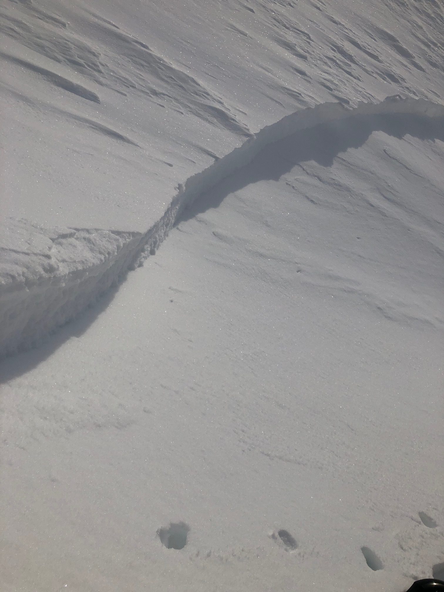
Crown line of an avalanche that failed on a layer of buried surface hoar in the Eddie’s spines on Sunday. Photo: Peter Ostroski. 02.21.2021

Weather
Tue, February 23rd, 2021

Yesterday: Northwest winds were blowing 5-10 mph at ridgelines, with gusts of 20-25 mph. Channelized flow at mid and low elevations resulted in southerly winds on the east side of Turnagain Pass. Highs were in the single digits F at ridgelines and in the low 20’s F at lower elevations. Skies were mostly cloudy, and there was no precipitation recorded.

Today: A lull in the weather this morning will be short-lived, with increasing cloud cover and winds picking up during the day. Winds are expected to pick up to 15-20 mph out of the southeast as the weather pattern shifts, and temperatures will rise into the teens at upper elevations and the low to mid- 20’s at low elevations. No precipitation is expected until later tonight.

Tomorrow: Chances of snow increase tonight, with 3-5” possible by tomorrow morning and another 2-4” during the day. Southeasterly winds are expected to increase to 25-30 mph at ridgelines, and gusts of 40 mph. Temperatures continue to rise tonight, with overnight lows expected in the upper teens to upper 20’s F, and highs tomorrow in the low to upper 20’s F.

PRECIPITATION 24-hour data (6am – 6am)

Temp Avg (F) Snow (in) Water (in) Snow Depth (in)
Center Ridge (1880′) 11 0 0 113
Summit Lake (1400′) 6 0 0 43
Alyeska Mid (1700′) 11 0 0 111

RIDGETOP 24-hour data (6am – 6am)

Temp Avg (F) Wind Dir Wind Avg (mph) Wind Gust (mph)
Sunburst (3812′) 4 W 7 26
Seattle Ridge (2400′) 7 N 6 18
Observations
Recent Observations for Turnagain Pass
Date Region Location
04/16/24 Turnagain Observation: Cornbiscuit
04/15/24 Turnagain Observation: Taylor Pass
04/15/24 Turnagain Observation: Seward Highway – Tern Lake to Portage
04/14/24 Turnagain Observation: Sunburst
04/14/24 Turnagain Observation: Turnagain Pass Snomo
04/13/24 Turnagain Observation: Spokane Creek
04/11/24 Turnagain Observation: Tincan
04/10/24 Turnagain Avalanche: Seattle Ridge
04/10/24 Turnagain Observation: Cornbiscuit South Face
04/10/24 Turnagain Avalanche: Tincan
Riding Areas

The riding areas page has moved. Please click here & update your bookmarks.


Subscribe to Turnagain Pass
Avalanche Forecast by Email

This is a general backcountry avalanche advisory issued for Turnagain Arm with Turnagain Pass as the core advisory area. This advisory does not apply to highways, railroads or operating ski areas.