Turnagain Pass Avalanche Forecast RSS

Archives
ARCHIVED FORECAST - All forecasts expire after 24 hours from the posting date/time.
Issued
Sun, February 21st, 2021 - 7:00AM
Expires
Mon, February 22nd, 2021 - 7:00AM
Forecaster
Andrew Schauer
Avalanche risk The Bottom Line

Today’s avalanche danger is MODERATE, and it remains possible to trigger an avalanche on weak layers of snow buried 1-2’ deep. These persistent weak layers can be difficult to manage since they take a long time to heal and will sometimes, not always, give warning signs like shooting cracks and collapsing prior to avalanching. Adjust your terrain use accordingly, and consider the consequences of triggering an avalanche before moving out onto steep slopes.

Thanks to our sponsors!
Sun, February 21st, 2021
Alpine
Above 2,500'
Moderate (2)
Avalanche risk
Treeline
1,000'-2,500'
Moderate (2)
Avalanche risk
Below Treeline
Below 1,000'
Moderate (2)
Avalanche risk
Alpine
Above 2,500'
Avalanche risk
Moderate (2)
Treeline
1,000'-2,500'
Avalanche risk
Moderate (2)
Below Treeline
Below 1,000'
Avalanche risk
Moderate (2)
Danger Scale:
No Rating (0)
Low (1)
Moderate (2)
Considerable (3)
High (4)
Extreme (5)
Avalanche Problem 1
  • Persistent Slabs
    Persistent Slabs
  • Almost Certain
    Very Likely
    Likely
    Possible
    Unlikely
    Likelihood
  • Historic (D4-5)
    Very Large (D3)
    Large (D2)
    Small (D1)
    Size
Persistent Slabs
Persistent Slab avalanches are the release of a cohesive layer of snow (a slab) in the middle to upper snowpack, when the bond to an underlying persistent weak layer breaks. Persistent layers include: surface hoar, depth hoar, near-surface facets, or faceted snow. Persistent weak layers can continue to produce avalanches for days, weeks or even months, making them especially dangerous and tricky. As additional snow and wind events build a thicker slab on top of the persistent weak layer, this avalanche problem may develop into a Deep Persistent Slab.

Likelihood of Avalanches
Terms such as "unlikely", "likely", and "certain" are used to define the scale, with the chance of triggering or observing avalanches increasing as we move up the scale. For our purposes, "Unlikely" means that few avalanches could be triggered in avalanche terrain and natural avalanches are not expected. "Certain" means that humans will be able to trigger avalanches on many slopes, and natural avalanches are expected.

Size of Avalanches
Avalanche size is defined by the largest potential avalanche, or expected range of sizes related to the problem in question. Assigned size is a qualitative estimate based on the destructive classification system and requires specialists to estimate the harm avalanches may cause to hypothetical objects located in the avalanche track (AAA 2016, CAA 2014). Under this schema, "Small" avalanches are not large enough to bury humans and are relatively harmless unless they carry people over cliffs or through trees or rocks. Moving up the scale, avalanches become "Large" enough to bury, injure, or kill people. "Very Large" avalanches may bury or destroy vehicles or houses, and "Historic" avalanches are massive events capable of altering the landscape.

Signal Word Size (D scale) Simple Descriptor
Small 1 Unlikely to bury a person
Large 2 Can bury a person
Very Large 3 Can destroy a house
Historic 4 & 5 Can destroy part or all of a village
More info at Avalanche.org

It is still possible to trigger an avalanche on two different persistent weak layers in the upper 2’ of the snowpack. One is a layer of surface hoar that was buried on 1/28, and the other is a combination of near-surface facets and surface hoar that was buried on 2/9. Both of these layers are slowly becoming more stubborn to trigger, but they are still showing that they are capable of producing avalanches. Most recently, we have seen human-triggered avalanches on these layers in Placer on Friday, and on Notch on Thursday. Yesterday we felt and heard a large collapse while skinning up Shark’s Fin, which was all the information we needed to adjust our plans and seek out lower-angle terrain (more details here).

We have found these layers across our advisory area, and they have shown up at all of our elevation bands. This includes lower elevations, where weak snow sitting on top of a rain crust can be even more sensitive. The tough thing about these layers is that they will not always show clear signs of instability before avalanching. But the recent avalanches, poor stability tests, and red flags that we have seen throughout the area are all indicating that it is still possible to trigger avalanches on these weak layers. With this kind of uncertainty in the snowpack, the only way to minimize your risk is to avoid consequential terrain. If you are trying to get on steeper slopes, consider the consequences of getting caught and carried in an avalanche. Are there cliffs, trees, or rocks below? Would an avalanche run into a gully or an abrupt transition and pile up debris especially deep? Is the slope big enough that getting dragged down it would result in serious injuries or worse? It is tough dealing with these persistent weak layers, but the best way to deal with them is to dial down your terrain choices until the snowpack can gain more strength.

Wind slabs: While today’s light winds are not expected to create widespread wind slab conditions, it might still be possible to find isolated pockets of wind-loaded snow that will be sensitive to human triggers. A stiffer slab of wind-drifted snow at the surface will also make it easier to trigger an avalanche on the persistent weak layers buried just a little bit deeper.

Sluffs: It will be easy to trigger loose snow avalanches (sluffs) on steep terrain that has been sheltered from recent winds. It is unlikely an avalanche like this would be big enough to bury a person, but they can have serious consequences if they carry you into terrain traps like cliffs, rocks, or trees.

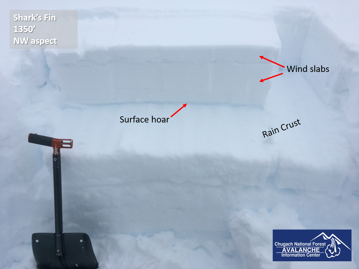
This layer of buried surface hoar on top of a rain crust was giving us poor stability results in snow pits, and also resulted in a large collapse as we were approaching Shark’s Fin yesterday. 02.20.2021

Buried rain crust from 850′ at Turnagain Pass. 02.20.2021

Weather
Sun, February 21st, 2021

Yesterday: High temperatures reached the low teens to low 20’s F under cloudy skies. Easterly winds were blowing 10-15 mph at the ridgetops for most of the day before calming to 5-10 mph overnight. Light snowfall brought a trace of new snow.

Today: Temperatures are expected to remain cold, with temperatures in the single digits below 0 F to 10 F as of 6:00 a.m. and highs expected in the teens F. Light westerly winds are expected to blow between 5 and 15 mph, with gusts to 20 mph and winds calming during the day. Skies will be mostly cloudy, with visibility improving later in the day. Little or no precipitation is expected today.

Tomorrow: Our cold snap continues tomorrow, with high temperatures expected in the single digits to 10 F under partly cloudy skies. Winds are expected to increase tomorrow, blowing 10-20 mph out of the northwest. No precipitation is expected tomorrow.

PRECIPITATION 24-hour data (6am – 6am)

Temp Avg (F) Snow (in) Water (in) Snow Depth (in)
Center Ridge (1880′) 12 tr 0.1 114
Summit Lake (1400′) 8 0 0 44
Alyeska Mid (1700′) 12 0 0 113

RIDGETOP 24-hour data (6am – 6am)

Temp Avg (F) Wind Dir Wind Avg (mph) Wind Gust (mph)
Sunburst (3812′) 10 NE-NW 10 31
Seattle Ridge (2400′) 10 E 4 17
Observations
Recent Observations for Turnagain Pass
Date Region Location
05/22/23 Turnagain Avalanche: Tincan
05/12/23 Turnagain Avalanche: Tincan, Sunburst, Magnum, Cornbiscuit
05/07/23 Turnagain Observation: Tincan – Bear Tracks
05/05/23 Turnagain Observation: Seattle Ridge
05/02/23 Turnagain Observation: Cornbiscuit
05/02/23 Turnagain Observation: Seward Hwy Turnagain Pass
04/30/23 Turnagain Observation: Magnum
04/29/23 Turnagain Observation: Tincan
04/28/23 Turnagain Avalanche: Taylor Pass/Pastoral
04/28/23 Turnagain Avalanche: Tincan
Riding Areas
Updated Sat, September 23rd, 2023

Status of riding areas across the Chugach NF is managed by the Glacier and Seward Ranger Districts, not avalanche center staff. Riding area information is posted as a public service to our users and updated based on snow depth and snow density to prevent resource damage at trailhead locations. Riding area questions contact: mailroom_r10_chugach@fs.fed.us

Area Status Weather & Riding Conditions
Glacier District
Johnson Pass
Closed
Scheduled opening per Chugach National Forest plan December 1. Subject to adequate snow cover.
Placer River
Closed
Scheduled opening per Chugach National Forest plan December 1. Subject to adequate snow cover.
Skookum Drainage
Closed
Scheduled opening per Chugach National Forest plan December 1. Subject to adequate snow cover.
Turnagain Pass
Closed
Scheduled opening on the Wednesday before Thanksgiving per Chugach National Forest plan. Subject to adequate snow cover.
Twentymile
Closed
Scheduled opening per Chugach National Forest plan December 1. Subject to adequate snow cover.
Seward District
Carter Lake
Closed
Scheduled opening per Chugach National Forest plan December 1. Subject to adequate snow cover.
Lost Lake Trail
Closed
Scheduled opening per Chugach National Forest plan December 1. Subject to adequate snow cover.
Primrose Trail
Closed
Scheduled opening per Chugach National Forest plan December 1. Subject to adequate snow cover.
Resurrection Pass Trail
Closed
Scheduled opening per Chugach National Forest plan December 1. Subject to adequate snow cover.
Snug Harbor
Closed
Scheduled opening per Chugach National Forest plan December 1. Subject to adequate snow cover.
South Fork Snow River Corridor
Closed
Scheduled opening per Chugach National Forest plan December 1. Subject to adequate snow cover.
Summit Lake
Closed
Scheduled opening per Chugach National Forest plan December 1. Subject to adequate snow cover.

Subscribe to Turnagain Pass
Avalanche Forecast by Email

This is a general backcountry avalanche advisory issued for Turnagain Arm with Turnagain Pass as the core advisory area. This advisory does not apply to highways, railroads or operating ski areas.