Turnagain Pass RSS

Archives
ARCHIVED - Forecasts expire after 24 hours.
Issued
Thu, February 18th, 2021 - 7:00AM
Expires
Fri, February 19th, 2021 - 7:00AM
Forecaster
Aleph Johnston-Bloom
Avalanche risk The Bottom Line

The avalanche danger is MODERATE. Triggering a slab 1-2′ deep is possible on slopes 35° degrees and steeper. Terrain that has been recently wind-loaded is most suspect. Keep in mind that there are buried weak layers in the snowpack. In addition, recent snowfall amounts, wind effect and the depth and reactivity of the buried weak snow is really variable across the forecast area. Assess the snowpack as you travel, identify areas of concern and evaluate terrain consequences.

PLACER/PORTAGE: These areas have seen more snowfall in the last 48 hrs than the rest of the forecast area, and already have more snow sitting on top of the buried weak layers. This could make larger avalanches easier to trigger, and extra caution is advised.

Special Announcements

Heading to Hatcher Pass? Be sure to check the Thursday Conditions Summary at hpavalanche.org.

Thu, February 18th, 2021
Alpine
Above 2,500'
2 - Moderate
Avalanche risk
Treeline
1,000'-2,500'
2 - Moderate
Avalanche risk
Below Treeline
Below 1,000'
2 - Moderate
Avalanche risk
0 - No Rating
1 - Low
2 - Moderate
3 - Considerable
4 - High
5 - Extreme
Avalanche risk Avalanche risk Avalanche risk Avalanche risk Avalanche risk
Travel Advice Generally safe avalanche conditions. Watch for unstable snow on isolated terrain features. Heightened avalanche conditions on specific terrain features. Evaluate snow and terrain carefully; identify features of concern. Dangerous avalanche conditions. Careful snowpack evaluation, cautious route-finding, and conservative decision-making essential. Very dangerous avalanche conditions. Travel in avalanche terrain not recommended. Extraordinarily dangerous avalanche conditions. Avoid all avalanche terrain.
Likelihood of Avalanches Natural and human-triggered avalanches unlikely. Natural avalanches unlikely; human-triggered avalanches possible. Natural avalanches possible; human-triggered avalanches likely. Natural avalanches likely; human-triggered avalanches very likely. Natural and human-triggered avalanches certain.
Avalanche Size and Distribution Small avalanches in isolated areas or extreme terrain. Small avalanches in specific areas; or large avalanches in isolated areas. Small avalanches in many areas; or large avalanches in specific areas; or very large avalanches in isolated areas. Large avalanches in many areas; or very large avalanches in specific areas. Very large avalanches in many areas.
Avalanche Problem 1
  • Persistent Slabs
    Persistent Slabs
  • Certain
    Very Likely
    Likely
    Possible
    Unlikely
    Likelihood
  • Historic (D4-5)
    Very Large (D3)
    Large (D2)
    Small (D1)
    Size
Persistent Slabs
Persistent Slab avalanches are the release of a cohesive layer of snow (a slab) in the middle to upper snowpack, when the bond to an underlying persistent weak layer breaks. Persistent layers include: surface hoar, depth hoar, near-surface facets, or faceted snow. Persistent weak layers can continue to produce avalanches for days, weeks or even months, making them especially dangerous and tricky. As additional snow and wind events build a thicker slab on top of the persistent weak layer, this avalanche problem may develop into a Deep Persistent Slab.

Likelihood of Avalanches
Terms such as "unlikely", "likely", and "certain" are used to define the scale, with the chance of triggering or observing avalanches increasing as we move up the scale. For our purposes, "Unlikely" means that few avalanches could be triggered in avalanche terrain and natural avalanches are not expected. "Certain" means that humans will be able to trigger avalanches on many slopes, and natural avalanches are expected.

Size of Avalanches
Avalanche size is defined by the largest potential avalanche, or expected range of sizes related to the problem in question. Assigned size is a qualitative estimate based on the destructive classification system and requires specialists to estimate the harm avalanches may cause to hypothetical objects located in the avalanche track (AAA 2016, CAA 2014). Under this schema, "Small" avalanches are not large enough to bury humans and are relatively harmless unless they carry people over cliffs or through trees or rocks. Moving up the scale, avalanches become "Large" enough to bury, injure, or kill people. "Very Large" avalanches may bury or destroy vehicles or houses, and "Historic" avalanches are massive events capable of altering the landscape.

Signal Word Size (D scale) Simple Descriptor
Small 1 Unlikely to bury a person
Large 2 Can bury a person
Very Large 3 Can destroy a house
Historic 4 & 5 Can destroy part or all of a village
More info at Avalanche.org

As emphasized above in the bottom line there is a lot of variability with the current snowpack. If you head out today you need to be a bit of a detective and approach avalanche terrain with caution. There is new snow and a recent wind event. There are layers of buried weak snow. Triggering a slab avalanche is possible in steep terrain. The weather forecast for today includes light snowfall and shifting winds.

What you need to keep in mind:

  1. A few inches of snow fell last night without much wind. This may have covered up evidence of prior wind effect. It was windy Tuesday night potentially creating wind slabs that may be harder identify today. Pay attention to increasing winds this afternoon as the wind shifts to the northwest. .
  2. Snowfall over the past couple of days has favored Girdwood, Portage and Placer so expect slabs to be deeper in these areas.
  3. Warm heavier snow has fallen over colder light snow, so small storms slabs may be possible in protected terrain.
  4. There are a couple of buried weak layers (facets and surface hoar) in the snowpack. In some locations recent snowpack tests are showing that these persistent layers are still reactive. This indicates that triggering a wind or storm slab avalanche could potentially step down to one of these layers, creating a larger more connected avalanche if you find the wrong spot. In other locations tests are showing signs of becoming less reactive but there is not enough of a definitive pattern to be confident. This uncertainty is makes the whole situation tricky and the snowpack not that trustworthy…
  5. Another factor is a buried melt-freeze crust with weak snow above it that goes from sea level to around 1600′ at Turnagain Pass and up to 2000′ in Girdwood and Placer. This combined with a deeper slab on top could make the low and mid elevation steep terrain more suspect.

What to do with all this information if you go out today?

Look for signs of instability like cracking and whumpfing.  Try to figure out if there is wind affected snow and a slab. Is there punchy, hollow-sounding snow? Can you feel really hard snow in wind-loaded area where your skis or track don’t sink in? This could be a hard wind slab over weak snow and could break once you get onto the slope. Don’t forget that weak snow is lurking in the snowpack! Think about the consequences if a slope does slide and as always use good travel protocol. Because of the variability and the buried weak layers approach avalanche terrain with extra skepticism.

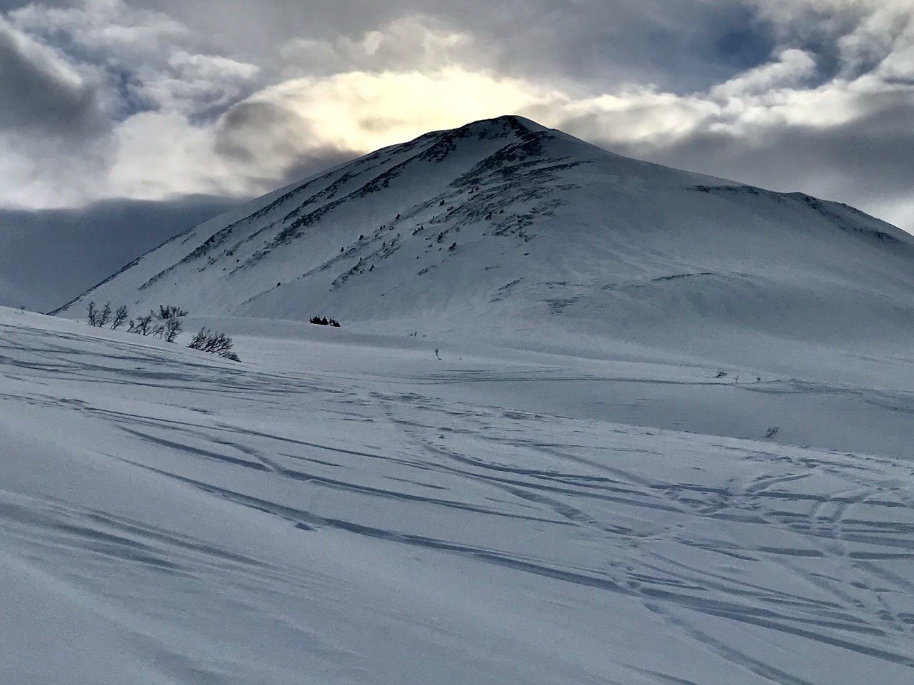
Wind effect on Magnum, 2.17.21. What terrain is loaded? Where might there be a slab? 

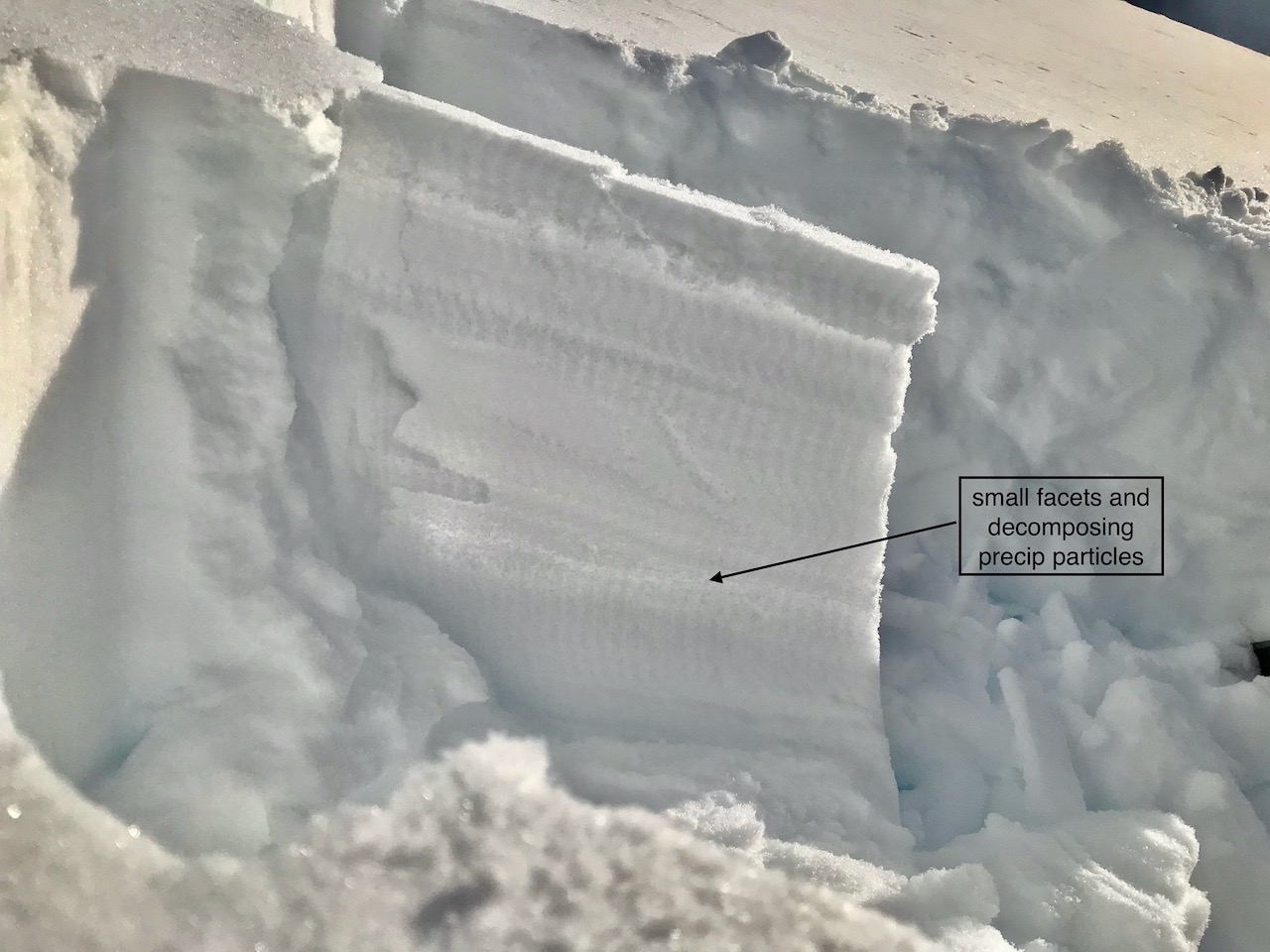
Buried weak layer in the snowpack on Sunburst 2.17.21.

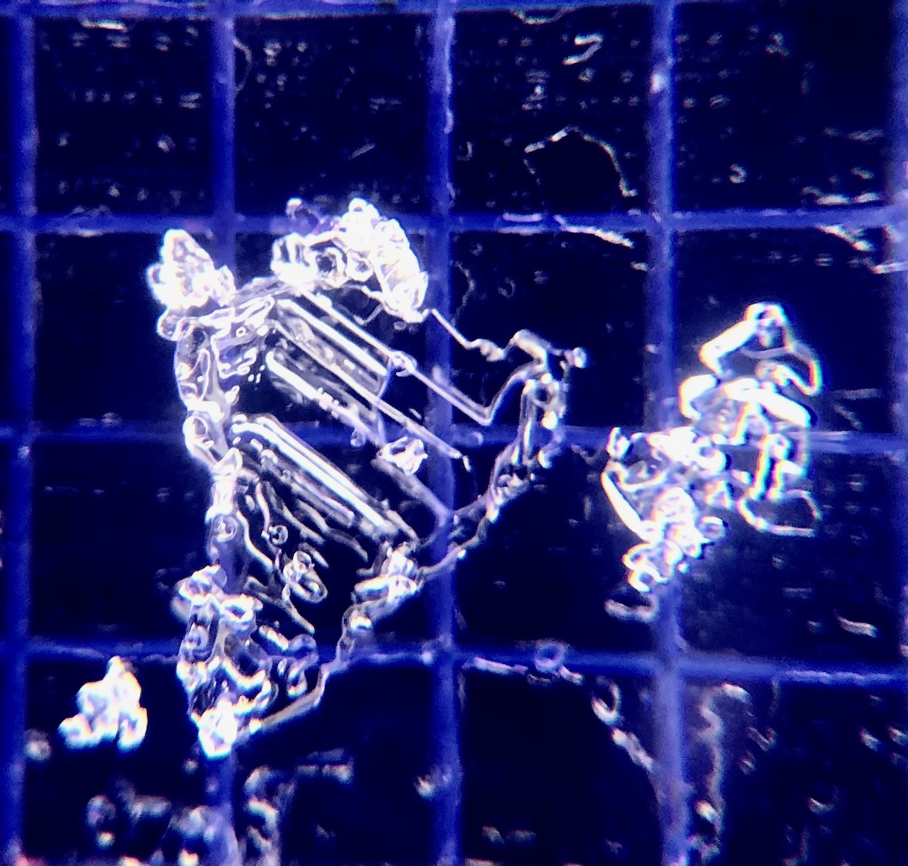
A buried surface hoar grain from the snowpack at 3150′ on Sunburst, 2.17.21. Photo: Eric Roberts

Weather
Thu, February 18th, 2021

Yesterday: Skies were mostly cloudy with light rain and snow showers in the morning becoming partly cloudy mid-day. Winds were easterly and gusty until around 10 am and then became light for the remainder of the day. Temperatures were in the 20°Fs at ridgetops and 30°Fs from sea level to up to mid elevation weather stations. There was snow overnight, 1-4″ with rain falling at sea level. Winds were light and easterly and temperatures were in the 20°F s to mid 30°Fs.

Today: Skies will be mostly cloudy with light precipitation tapering off in the afternoon. Temperatures will be in the 30°Fs at low elevations and 20°Fs in the alpine. Winds will be light and easterly shifting to the west in the late afternoon and increasing to 10-15 mph. Overnight skies will be partly cloudy becoming mostly clear early Friday. Temperatures cool down into the teens and single digits. Winds will be northwesterly 15-25 mph with gusts into the 30s.

Tomorrow: Skies will be mostly clear with temperatures in the teens and low 20°Fs. Winds will remain northwesterly 15-25 mph with gusts into the 30s eventually easing off overnight. Partly sunny skies for the weekend with light winds and temperatures in the teens and 20°Fs.

PRECIPITATION 24-hour data (6am – 6am)

Temp Avg (F) Snow (in) Water (in) Snow Depth (in)
Center Ridge (1880′) 31 1 0.1 116
Summit Lake (1400′) 30 0 0 44
Alyeska Mid (1700′) 30 2.5 0.3 116

RIDGETOP 24-hour data (6am – 6am)

Temp Avg (F) Wind Dir Wind Avg (mph) Wind Gust (mph)
Sunburst (3812′) 21 NE 11 62
Seattle Ridge (2400′) 25 E 11 29
Observations
Recent Observations for Turnagain Pass
Date Region Location
03/28/24 Turnagain Observation: Sunburst
03/27/24 Turnagain Observation: Tincan Trees
03/26/24 Turnagain Observation: Cornbiscuit
03/25/24 Turnagain Observation: Tincan
03/22/24 Turnagain Avalanche: Magnum Northwest Aspect
03/21/24 Turnagain Observation: Sunburst
03/21/24 Turnagain Observation: Tincan Proper North Aspect
03/20/24 Turnagain Avalanche: Seattle Creek Drainage
03/19/24 Turnagain Observation: Tincan CFR
03/18/24 Turnagain Avalanche: Tincan – Eddies – Seattle Ridge
Riding Areas

The riding areas page has moved. Please click here & update your bookmarks.


Subscribe to Turnagain Pass
Avalanche Forecast by Email

This is a general backcountry avalanche advisory issued for Turnagain Arm with Turnagain Pass as the core advisory area. This advisory does not apply to highways, railroads or operating ski areas.