Turnagain Pass RSS

Archives
ARCHIVED - Forecasts expire after 24 hours.
Issued
Sat, February 11th, 2023 - 7:00AM
Expires
Sun, February 12th, 2023 - 7:00AM
Forecaster
John Sykes
Avalanche risk The Bottom Line

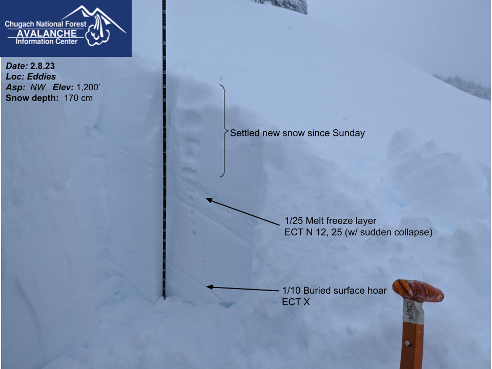
The avalanche danger is CONSIDERABLE above 1000′ today. Continued snowfall and moderate winds will make natural avalanches 1-3′ deep possible and human triggered avalanches likely. Areas with recent wind loading are most likely to harbor touchy avalanche conditions. In addition, a crust layer buried about 1-2′ deep at elevations below 2000′ could cause avalanches in sheltered areas. We recommend identifying terrain features with recent wind loading and paying close attention for red flags to avoid avalanches today. Below 1000′ the avalanche danger is MODERATE.

SUMMIT LAKE: Strong winds over the past 24 hours have impacted this area and avalanche danger is elevated. This area has a very weak existing snowpack and large avalanches on deeply buried weak layers are possible.

SEWARD/LOST LAKE/SNUG HARBOR: The Seward area is expected to be favored by snowfall today which will lead to increased avalanche danger. Keep an eye out for red flags and signs of recent wind loading to identify avalanche prone slopes.

Special Announcements

Join us on Valentine’s Day (Feb 14th) for Snowball! Dance to lively music by the Jangle Bees, bid on the silent auction, and enjoy 49th State Brewing libations and decadent desserts. Bring your sweetie or your best backcountry partners—or find new ones on the dance floor. All proceeds from this event benefit the Friends of the Chugach Avalanche Center and the Alaska Avalanche School, so you can let loose knowing it’s for a great cause! Tickets are limited, so get yours soon. Click here for tickets and more information.

Sat, February 11th, 2023
Alpine
Above 2,500'
3 - Considerable
Avalanche risk
Treeline
1,000'-2,500'
3 - Considerable
Avalanche risk
Below Treeline
Below 1,000'
2 - Moderate
Avalanche risk
0 - No Rating
1 - Low
2 - Moderate
3 - Considerable
4 - High
5 - Extreme
Avalanche risk Avalanche risk Avalanche risk Avalanche risk Avalanche risk
Travel Advice Generally safe avalanche conditions. Watch for unstable snow on isolated terrain features. Heightened avalanche conditions on specific terrain features. Evaluate snow and terrain carefully; identify features of concern. Dangerous avalanche conditions. Careful snowpack evaluation, cautious route-finding, and conservative decision-making essential. Very dangerous avalanche conditions. Travel in avalanche terrain not recommended. Extraordinarily dangerous avalanche conditions. Avoid all avalanche terrain.
Likelihood of Avalanches Natural and human-triggered avalanches unlikely. Natural avalanches unlikely; human-triggered avalanches possible. Natural avalanches possible; human-triggered avalanches likely. Natural avalanches likely; human-triggered avalanches very likely. Natural and human-triggered avalanches certain.
Avalanche Size and Distribution Small avalanches in isolated areas or extreme terrain. Small avalanches in specific areas; or large avalanches in isolated areas. Small avalanches in many areas; or large avalanches in specific areas; or very large avalanches in isolated areas. Large avalanches in many areas; or very large avalanches in specific areas. Very large avalanches in many areas.
Recent Avalanches

No new avalanches were reported yesterday. On Thursday there were two human triggered avalanches, one on Cornbiscuit and one on Seattle Ridge, that both seem to be related to lingering wind slabs that were not bonding well with the old snow surface.

Detailed view of the human triggered avalanche from Cornbiscuit on Thrusday. Photo 2.9.23 from Peter Wadsworth

Avalanche Problem 1
  • Wind Slabs
    Wind Slabs
  • Aspect/Elevation
  • Certain
    Very Likely
    Likely
    Possible
    Unlikely
    Likelihood
  • Historic (D4-5)
    Very Large (D3)
    Large (D2)
    Small (D1)
    Size
Wind Slabs
Wind Slab avalanches are the release of a cohesive layer of snow (a slab) formed by the wind. Wind typically transports snow from the upwind sides of terrain features and deposits snow on the downwind side. Wind slabs are often smooth and rounded and sometimes sound hollow, and can range from soft to hard. Wind slabs that form over a persistent weak layer (surface hoar, depth hoar, or near-surface facets) may be termed Persistent Slabs or may develop into Persistent Slabs.

Aspect/Elevation of the Avalanche Problem
Specialists develop a graphic representation of the potential distribution of a particular avalanche problem across the topography. This aspect/elevation rose is used to indicate where the particular avalanche problem is thought to exist on all elevation aspects. Areas where the avalanche problem is thought to exist are colored grey, and it is less likely to be encountered in areas colored white.

Likelihood of Avalanches
Terms such as "unlikely", "likely", and "certain" are used to define the scale, with the chance of triggering or observing avalanches increasing as we move up the scale. For our purposes, "Unlikely" means that few avalanches could be triggered in avalanche terrain and natural avalanches are not expected. "Certain" means that humans will be able to trigger avalanches on many slopes, and natural avalanches are expected.

Size of Avalanches
Avalanche size is defined by the largest potential avalanche, or expected range of sizes related to the problem in question. Assigned size is a qualitative estimate based on the destructive classification system and requires specialists to estimate the harm avalanches may cause to hypothetical objects located in the avalanche track (AAA 2016, CAA 2014). Under this schema, "Small" avalanches are not large enough to bury humans and are relatively harmless unless they carry people over cliffs or through trees or rocks. Moving up the scale, avalanches become "Large" enough to bury, injure, or kill people. "Very Large" avalanches may bury or destroy vehicles or houses, and "Historic" avalanches are massive events capable of altering the landscape.

Signal Word Size (D scale) Simple Descriptor
Small 1 Unlikely to bury a person
Large 2 Can bury a person
Very Large 3 Can destroy a house
Historic 4 & 5 Can destroy part or all of a village
More info at Avalanche.org

The wind showed up right on cue yesterday, with average wind speeds of 20+ mph and gusts of 40+ mph from 10 am through 11 pm at upper elevations. Snowfall accompanied the strong winds and Turnagain Pass has picked up 5″ of new snow as of early Saturday morning. Girdwood was not favored for snowfall yesterday with just 1-2″ reported in the past 24 hours. More new snow is expected today with 2-4″ of additional snowfall possible in Turnagain Pass and Girdwood and higher totals near Portage. Winds will be lighter compared to yesterday with averages of 10-20 mph and gusts into the 30s, but still strong enough to transport new snow into wind slabs.

Natural avalanches 1-3′ deep in areas with recent wind loading are possible today and human triggered avalanches are likely. Identifying features that have been recently wind loaded will be important to avoid avalanches today. Looking for wind loading patterns on the snow surface and stepping off the beaten path to feel the snow surface with your machine or ski poles are good ways to get a sense of the distribution of wind loaded terrain features. Small tests slopes can also be useful to check how reactive surface wind slabs are before committing to larger terrain features.

In areas that might have seen higher snow totals yesterday, like on the northern end of Turnagain Pass, it may be possible to trigger a storm snow avalanche in sheltered areas if the new snow is not bonding well to the old snow surface. Below 2000′ there is a melt freeze crust from 1/25 about a foot deep in the snowpack that has shown signs of not bonding well with the storm snow from earlier this week. With a new snow load and wind potentially making the surface snow more cohesive this layer might be able to produce storm slabs 1-2′ deep today. This layer is a little unusual since it only exists at lower elevations and has the potential to catch people off guard. Keep an eye out for red flags like shooting cracks and whumphing or better yet dig a snowpit to evaluate whether this weak layer is problematic in the area you are travelling.

Light snowfall is expected across the region today, with highest snow totals near Seward and Portage. Graphic from NWS Anchorage 2.11.23

Example of a snowpack structure from earlier this week with the problematic 1/25 melt freeze crust buried about a foot deep. Photo 2.8.23

Avalanche Problem 2
  • Persistent Slabs
    Persistent Slabs
  • Aspect/Elevation
  • Certain
    Very Likely
    Likely
    Possible
    Unlikely
    Likelihood
  • Historic (D4-5)
    Very Large (D3)
    Large (D2)
    Small (D1)
    Size
Persistent Slabs
Persistent Slab avalanches are the release of a cohesive layer of snow (a slab) in the middle to upper snowpack, when the bond to an underlying persistent weak layer breaks. Persistent layers include: surface hoar, depth hoar, near-surface facets, or faceted snow. Persistent weak layers can continue to produce avalanches for days, weeks or even months, making them especially dangerous and tricky. As additional snow and wind events build a thicker slab on top of the persistent weak layer, this avalanche problem may develop into a Deep Persistent Slab.

Aspect/Elevation of the Avalanche Problem
Specialists develop a graphic representation of the potential distribution of a particular avalanche problem across the topography. This aspect/elevation rose is used to indicate where the particular avalanche problem is thought to exist on all elevation aspects. Areas where the avalanche problem is thought to exist are colored grey, and it is less likely to be encountered in areas colored white.

Likelihood of Avalanches
Terms such as "unlikely", "likely", and "certain" are used to define the scale, with the chance of triggering or observing avalanches increasing as we move up the scale. For our purposes, "Unlikely" means that few avalanches could be triggered in avalanche terrain and natural avalanches are not expected. "Certain" means that humans will be able to trigger avalanches on many slopes, and natural avalanches are expected.

Size of Avalanches
Avalanche size is defined by the largest potential avalanche, or expected range of sizes related to the problem in question. Assigned size is a qualitative estimate based on the destructive classification system and requires specialists to estimate the harm avalanches may cause to hypothetical objects located in the avalanche track (AAA 2016, CAA 2014). Under this schema, "Small" avalanches are not large enough to bury humans and are relatively harmless unless they carry people over cliffs or through trees or rocks. Moving up the scale, avalanches become "Large" enough to bury, injure, or kill people. "Very Large" avalanches may bury or destroy vehicles or houses, and "Historic" avalanches are massive events capable of altering the landscape.

Signal Word Size (D scale) Simple Descriptor
Small 1 Unlikely to bury a person
Large 2 Can bury a person
Very Large 3 Can destroy a house
Historic 4 & 5 Can destroy part or all of a village
More info at Avalanche.org

The added stress of new snowfall and wind loading might be enough to reactivate our buried weak layers today. The most concerning layer is the 1/10 buried surface hoar which could produce large 2-4′ deep avalanches in isolated areas where the weak layer is well preserved. Since this layer is now buried pretty deeply it is difficult to test without stopping to dig a snowpit and using a compression test or extended column test. Over the past two weeks we have seen this layer acting mostly unreactive, with the exception of one snowpit on Pete’s N (see video here) where the layer was well preserved and very reactive in snowpit tests during an active loading period.  To avoid this problem entirely you can simply stick to low angle terrain and give the snowpack some time to adjust to the new load.

Pesky layer of 1/10 buried surface hoar still widespread in the forecast area, but seems to only be reactive in isolated areas where it is well preserved. Photo 2.8.23

Additional Concern
  • Deep Persistent Slabs
    Deep Persistent Slabs
Deep Persistent Slabs
Deep Persistent Slab avalanches are the release of a thick cohesive layer of hard snow (a slab), when the bond breaks between the slab and an underlying persistent weak layer deep in the snowpack. The most common persistent weak layers involved in deep, persistent slabs are depth hoar or facets surrounding a deeply buried crust. Deep Persistent Slabs are typically hard to trigger, are very destructive and dangerous due to the large mass of snow involved, and can persist for months once developed. They are often triggered from areas where the snow is shallow and weak, and are particularly difficult to forecast for and manage.
More info at Avalanche.org

In areas with a thin overall snowpack, like near Silvertip and the southern end of the forecast region, there are deeper weak layers near the base of the snowpack that are concerning. The most widespread weak layer is the Thanksgiving facet/crust combo but in some areas there is also a weak layer of basal facets that is concerning. With active weather today it is possible that these deeper weak layer could become active again and produce very large avalanches.

Weather
Sat, February 11th, 2023

Yesterday: Strong winds started yesterday morning and quickly ramped up to averages of 30-45 mph with gusts to 70 mph at upper elevations. Snowfall totals seem to favor Turnagain Pass and Portage over Girdwood. As of early Saturday morning 5″ of snow has fallen at Turnagain Pass. Temperatures remained in the teens at upper elevations yesterday and increased to the low 30s at sea level.

Today: Wind speeds are expected to decrease today with averages of 10-20 mph and gusts into the 30s. Snowfall should continue throughout they day with an additional 2-3″ expected at Turnagain Pass and 3-4″ in Girdwood. Temperatures should climb into the 20s at upper elevations and low 30s at lower elevations. Snow line should be at 400-500′ today.

Tomorrow: Continued light snowfall is expected tomorrow with an additional 1-2″ of accumulation. Cloud cover is expected to linger with a possible brief clearing period on Monday before another storm moves into the area in the middle of next week. Temperatures should decrease Sunday afternoon and head back towards the single digits at upper elevations on Monday. Winds will shift to NW Sunday afternoon and remain moderate with averages of 10 to 20 mph.

PRECIPITATION 24-hour data (6am – 6am)

Temp Avg (F) Snow (in) Water (in) Snow Depth (in)
Center Ridge (1880′) 23 5 0.4 72
Summit Lake (1400′) 23 1 0.1 35
Alyeska Mid (1700′) 22 1 0.1 68
Bear Valley – Portage (132′) 30 3 0.7

RIDGETOP 24-hour data (6am – 6am)

Temp Avg (F) Wind Dir Wind Avg (mph) Wind Gust (mph)
Sunburst (3812′) 14 ENE 25 68
Seattle Ridge (2400′) 18 SE 14 30
Observations
Recent Observations for Turnagain Pass
Date Region Location
04/23/24 Turnagain Observation: Turnagain Sunny Side
04/21/24 Turnagain Observation: Bertha Creek
04/20/24 Turnagain Avalanche: Spokane Creek
04/16/24 Turnagain Observation: Cornbiscuit
04/15/24 Turnagain Observation: Taylor Pass
04/15/24 Turnagain Observation: Seward Highway – Tern Lake to Portage
04/14/24 Turnagain Observation: Sunburst
04/14/24 Turnagain Observation: Turnagain Pass Snomo
04/13/24 Turnagain Observation: Spokane Creek
04/11/24 Turnagain Observation: Tincan
Riding Areas

The riding areas page has moved. Please click here & update your bookmarks.


Subscribe to Turnagain Pass
Avalanche Forecast by Email

This is a general backcountry avalanche advisory issued for Turnagain Arm with Turnagain Pass as the core advisory area. This advisory does not apply to highways, railroads or operating ski areas.