Turnagain Pass RSS

Archives
ARCHIVED - Forecasts expire after 24 hours.
Issued
Fri, February 10th, 2023 - 7:00AM
Expires
Sat, February 11th, 2023 - 7:00AM
Forecaster
John Sykes
Avalanche risk The Bottom Line

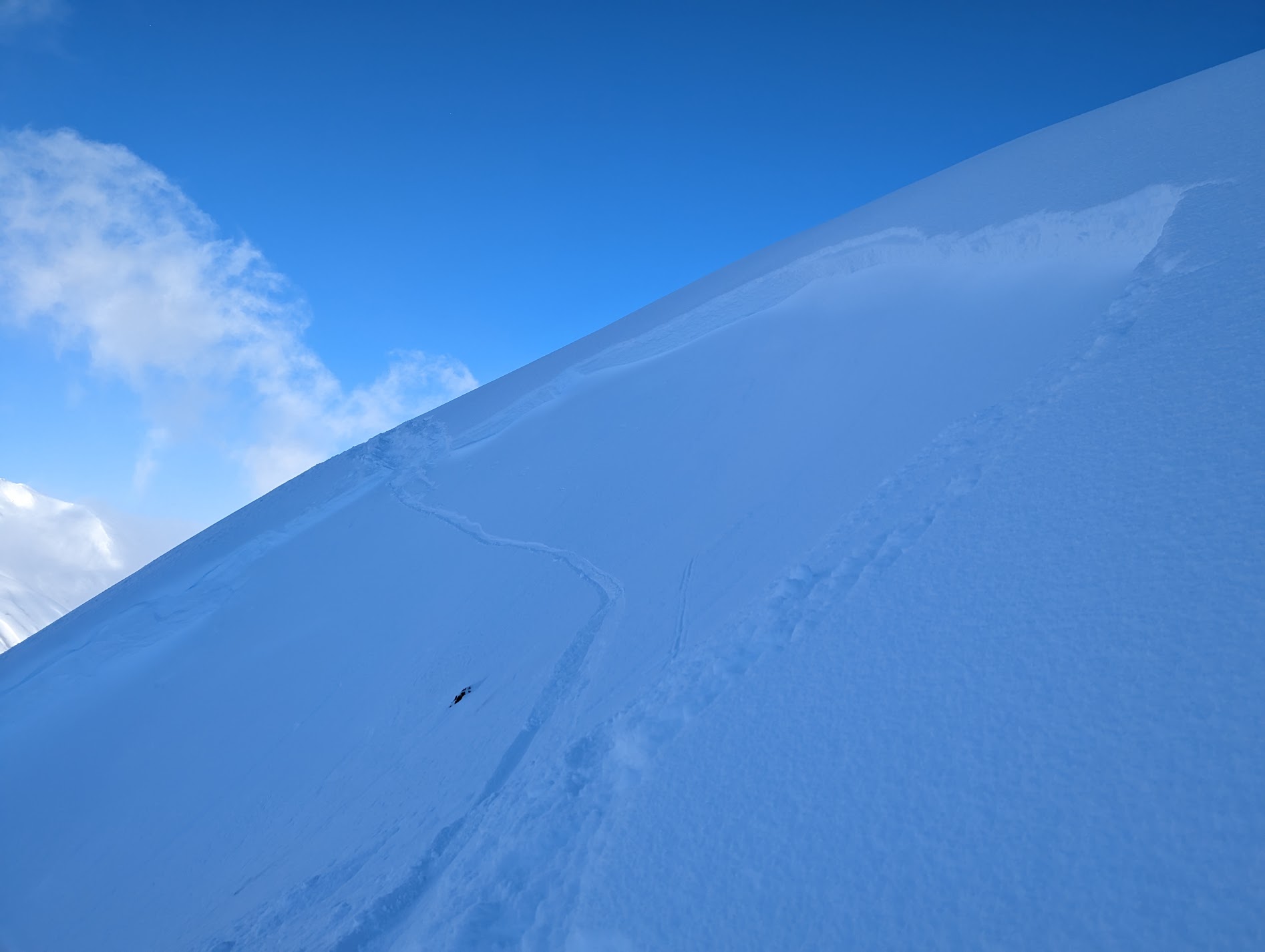
The avalanche danger will start off CONSIDERABLE and rise to HIGH today above 2500′. Strong winds and snowfall will make natural avalanches 1-3′ deep likely and human triggered avalanches very likely in areas with active wind loading. There is also a layer of buried surface hoar 2-4′ deep that could produce large avalanches in isolated areas. We recommend avoiding avalanche terrain at upper elevations, the avalanche danger will increase rapidly as the storm intensifies.

Below 2500′ the avalanche danger is CONSIDERABLE. Careful evaluation of the snowpack and conservative terrain selection is recommended. The new snow from this week has not bonded well with the old snow surface in areas below 2000′ where a melt freeze crust exists in the upper snowpack. The potential for avalanches on this weak layer at lower elevations may catch folks off guard.

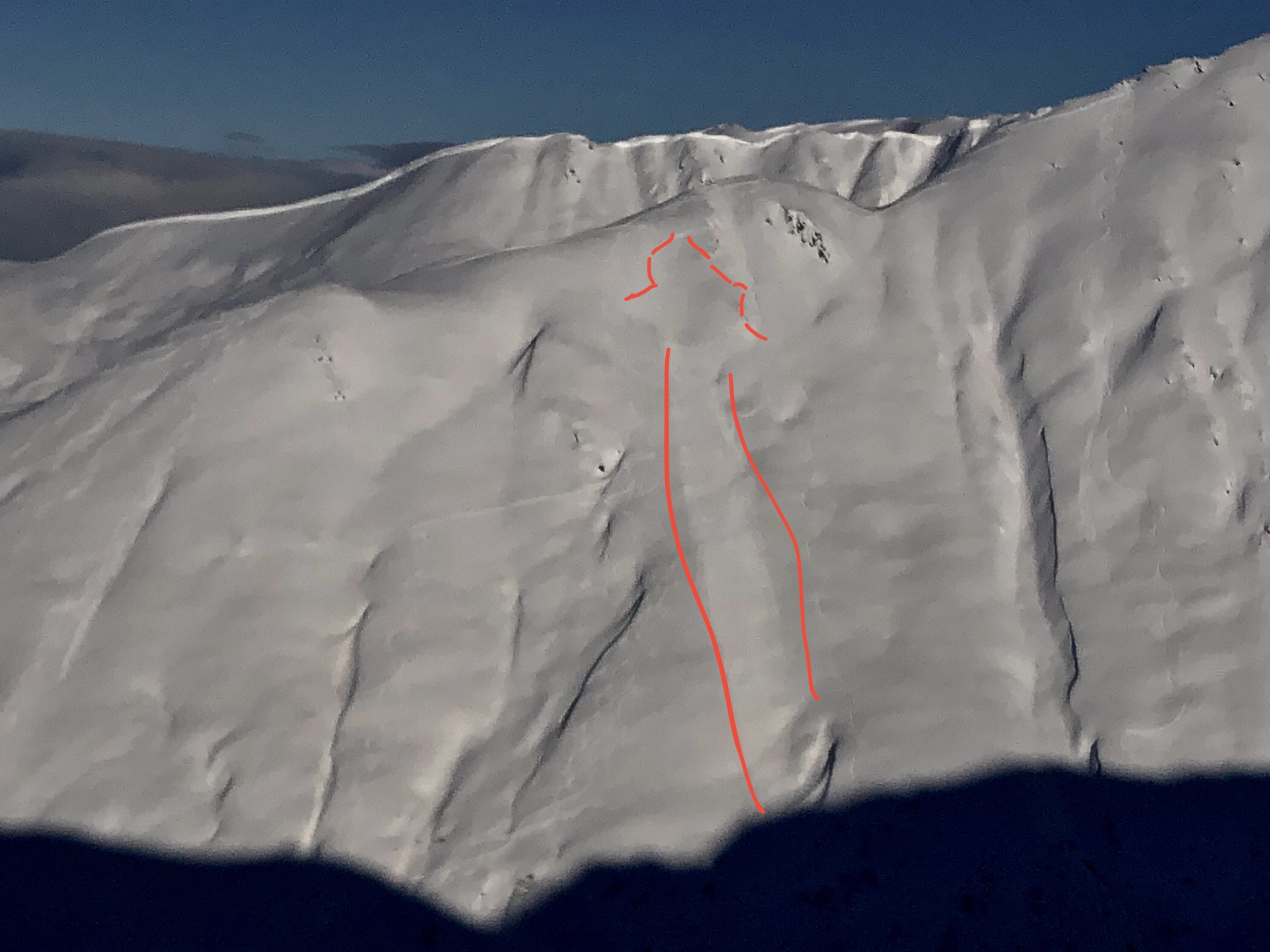
SUMMIT LAKE/LOST LAKE/SNUG HARBOR: Strong winds and snowfall will rapidly increase avalanche danger region wide. Very large avalanches are possible on deeply buried weak layers in areas with a shallower overall snowpack, like Summit Lake.

Special Announcements

Join us on Valentine’s Day (Feb 14th) for Snowball! Dance to lively music by the Jangle Bees, bid on the silent auction, and enjoy 49th State Brewing libations and decadent desserts. Bring your sweetie or your best backcountry partners—or find new ones on the dance floor. All proceeds from this event benefit the Friends of the Chugach Avalanche Center and the Alaska Avalanche School, so you can let loose knowing it’s for a great cause! Tickets are limited, so get yours soon. Click here for tickets and more information.

Fri, February 10th, 2023
Alpine
Above 2,500'
4 - High
Avalanche risk
Treeline
1,000'-2,500'
3 - Considerable
Avalanche risk
Below Treeline
Below 1,000'
3 - Considerable
Avalanche risk
0 - No Rating
1 - Low
2 - Moderate
3 - Considerable
4 - High
5 - Extreme
Avalanche risk Avalanche risk Avalanche risk Avalanche risk Avalanche risk
Travel Advice Generally safe avalanche conditions. Watch for unstable snow on isolated terrain features. Heightened avalanche conditions on specific terrain features. Evaluate snow and terrain carefully; identify features of concern. Dangerous avalanche conditions. Careful snowpack evaluation, cautious route-finding, and conservative decision-making essential. Very dangerous avalanche conditions. Travel in avalanche terrain not recommended. Extraordinarily dangerous avalanche conditions. Avoid all avalanche terrain.
Likelihood of Avalanches Natural and human-triggered avalanches unlikely. Natural avalanches unlikely; human-triggered avalanches possible. Natural avalanches possible; human-triggered avalanches likely. Natural avalanches likely; human-triggered avalanches very likely. Natural and human-triggered avalanches certain.
Avalanche Size and Distribution Small avalanches in isolated areas or extreme terrain. Small avalanches in specific areas; or large avalanches in isolated areas. Small avalanches in many areas; or large avalanches in specific areas; or very large avalanches in isolated areas. Large avalanches in many areas; or very large avalanches in specific areas. Very large avalanches in many areas.
Recent Avalanches

Lots of people got the memo about soft surface conditions and clear weather yesterday and were venturing into big terrain. We have reports of two human triggered avalanches yesterday, one from the south side of Cornbiscuit and one from BBQ bowl on Seattle Ridge (which is between -2 and -3 bowl from our motorozed place names map). Both of these avalanches appear to be relatively shallow slabs where there might have been lingering wind slabs or just poor bonding between the new snow from this week and the old snow surface. On Seattle ridge the party reported that the slab depth was about 18″. We also had a report of a glide avalanche release on Shark’s Fin and widespread loose snow avalanches in steep terrain and in areas getting intense solar input.

Photo of the crown from the Seattle Ridge BBQ bowl avalanche that was reported to be about 18″ deep. Photo 2.9.23 from Julia Dramis

Marked up photo of human triggered avalanche on S aspect of Cornbiscuit at about 3200′ taken from the Lipps ridgeline. Photo 2.9.23 from Allen Dahl

Avalanche Problem 1
  • Wind Slabs
    Wind Slabs
  • Aspect/Elevation
  • Certain
    Very Likely
    Likely
    Possible
    Unlikely
    Likelihood
  • Historic (D4-5)
    Very Large (D3)
    Large (D2)
    Small (D1)
    Size
Wind Slabs
Wind Slab avalanches are the release of a cohesive layer of snow (a slab) formed by the wind. Wind typically transports snow from the upwind sides of terrain features and deposits snow on the downwind side. Wind slabs are often smooth and rounded and sometimes sound hollow, and can range from soft to hard. Wind slabs that form over a persistent weak layer (surface hoar, depth hoar, or near-surface facets) may be termed Persistent Slabs or may develop into Persistent Slabs.

Aspect/Elevation of the Avalanche Problem
Specialists develop a graphic representation of the potential distribution of a particular avalanche problem across the topography. This aspect/elevation rose is used to indicate where the particular avalanche problem is thought to exist on all elevation aspects. Areas where the avalanche problem is thought to exist are colored grey, and it is less likely to be encountered in areas colored white.

Likelihood of Avalanches
Terms such as "unlikely", "likely", and "certain" are used to define the scale, with the chance of triggering or observing avalanches increasing as we move up the scale. For our purposes, "Unlikely" means that few avalanches could be triggered in avalanche terrain and natural avalanches are not expected. "Certain" means that humans will be able to trigger avalanches on many slopes, and natural avalanches are expected.

Size of Avalanches
Avalanche size is defined by the largest potential avalanche, or expected range of sizes related to the problem in question. Assigned size is a qualitative estimate based on the destructive classification system and requires specialists to estimate the harm avalanches may cause to hypothetical objects located in the avalanche track (AAA 2016, CAA 2014). Under this schema, "Small" avalanches are not large enough to bury humans and are relatively harmless unless they carry people over cliffs or through trees or rocks. Moving up the scale, avalanches become "Large" enough to bury, injure, or kill people. "Very Large" avalanches may bury or destroy vehicles or houses, and "Historic" avalanches are massive events capable of altering the landscape.

Signal Word Size (D scale) Simple Descriptor
Small 1 Unlikely to bury a person
Large 2 Can bury a person
Very Large 3 Can destroy a house
Historic 4 & 5 Can destroy part or all of a village
More info at Avalanche.org

Avalanche conditions will be changing dramatically today, from cold, clear, and calm yesterday to strong winds and snowfall today. Wind speeds should reach 50-60 mph out of the east with gusts of 75+ mph at upper elevations by noon today. Snowfall is expected throughout the daylight hours today with 3-6″ of accumulation by midnight tonight. The combination of strong winds, lots of soft snow on the surface, and new snowfall will RAPIDLY increase avalanche danger. Wind slab avalanches 1-3′ deep are likely to release naturally with this much loading and will be very likely for human triggering. We recommend avoiding avalanche terrain at upper elevations today, where the winds speeds and snowfall will be most intense.

At lower elevations we have seen evidence of poor bonding between the new snow from this week and a melt freeze crust that exists up to about 2000′. Wind transport and new snow today could be enough to make the slab on top of this crust a little stiffer and more likely to produce avalanches. Cautious route finding is recommended and careful evaluation of snowpack conditions even on low elevation terrain features that are typically safe. As always, keep an eye out for any red flags like shooting cracks or collapsing as a strong indicator that weak layers are becoming reactive under the stress of the new snow and wind.

This layer of wind loaded snow did not propagate in our extended column test but it did pop off pretty easily when we levered on back of the column. Photo 2.9.23

Avalanche Problem 2
  • Persistent Slabs
    Persistent Slabs
  • Aspect/Elevation
  • Certain
    Very Likely
    Likely
    Possible
    Unlikely
    Likelihood
  • Historic (D4-5)
    Very Large (D3)
    Large (D2)
    Small (D1)
    Size
Persistent Slabs
Persistent Slab avalanches are the release of a cohesive layer of snow (a slab) in the middle to upper snowpack, when the bond to an underlying persistent weak layer breaks. Persistent layers include: surface hoar, depth hoar, near-surface facets, or faceted snow. Persistent weak layers can continue to produce avalanches for days, weeks or even months, making them especially dangerous and tricky. As additional snow and wind events build a thicker slab on top of the persistent weak layer, this avalanche problem may develop into a Deep Persistent Slab.

Aspect/Elevation of the Avalanche Problem
Specialists develop a graphic representation of the potential distribution of a particular avalanche problem across the topography. This aspect/elevation rose is used to indicate where the particular avalanche problem is thought to exist on all elevation aspects. Areas where the avalanche problem is thought to exist are colored grey, and it is less likely to be encountered in areas colored white.

Likelihood of Avalanches
Terms such as "unlikely", "likely", and "certain" are used to define the scale, with the chance of triggering or observing avalanches increasing as we move up the scale. For our purposes, "Unlikely" means that few avalanches could be triggered in avalanche terrain and natural avalanches are not expected. "Certain" means that humans will be able to trigger avalanches on many slopes, and natural avalanches are expected.

Size of Avalanches
Avalanche size is defined by the largest potential avalanche, or expected range of sizes related to the problem in question. Assigned size is a qualitative estimate based on the destructive classification system and requires specialists to estimate the harm avalanches may cause to hypothetical objects located in the avalanche track (AAA 2016, CAA 2014). Under this schema, "Small" avalanches are not large enough to bury humans and are relatively harmless unless they carry people over cliffs or through trees or rocks. Moving up the scale, avalanches become "Large" enough to bury, injure, or kill people. "Very Large" avalanches may bury or destroy vehicles or houses, and "Historic" avalanches are massive events capable of altering the landscape.

Signal Word Size (D scale) Simple Descriptor
Small 1 Unlikely to bury a person
Large 2 Can bury a person
Very Large 3 Can destroy a house
Historic 4 & 5 Can destroy part or all of a village
More info at Avalanche.org

The addition of wind loading and new snow today could make our buried weak layers more reactive than we have seen in the past few days. The most concerning layer is the 1/10 buried surface hoar, which still exists across the forecast area 2-4′ deep but has been unreactive in snowpit tests recently. In isolated areas where this layer is well preserved it is possible to produce large human triggered avalanches 2-4′ deep with potentially wide propagation. The best way to evaluate whether it is possible to trigger an avalanche on this layer is to dig a snowpit and use a compression test or extended column test to check if the layer is reactive. However, with the active storm system today we are simply recommending avoiding avalanche terrain in the alpine and upper treeline elevations which is where this layer is most concerning.

Snowpack structure from Sunburst ridgeline with 1/10 buried surface hoar about 90 cm deep (3 ft). Photo 2.9.23


Additional Concern
  • Deep Persistent Slabs
    Deep Persistent Slabs
Deep Persistent Slabs
Deep Persistent Slab avalanches are the release of a thick cohesive layer of hard snow (a slab), when the bond breaks between the slab and an underlying persistent weak layer deep in the snowpack. The most common persistent weak layers involved in deep, persistent slabs are depth hoar or facets surrounding a deeply buried crust. Deep Persistent Slabs are typically hard to trigger, are very destructive and dangerous due to the large mass of snow involved, and can persist for months once developed. They are often triggered from areas where the snow is shallow and weak, and are particularly difficult to forecast for and manage.
More info at Avalanche.org

In areas with a thin overall snowpack, like near Silvertip and the southern end of the forecast region, there are deeper weak layers near the base of the snowpack that are concerning. The most widespread weak layer is the Thanksgiving facet/crust combo but in some areas there is also a weak layer of basal facets that is concerning. With active weather today it is possible that these deeper weak layer could become active again and produce very large avalanches.

Weather
Fri, February 10th, 2023

Yesterday: Clear and cold over Turnagain Pass with highs in the single digits at upper elevations, and clouds lingering along Turnagain Arm. Light winds at upper elevations in the 5-10 mph range. Some light new snow reported from Portage where the cloud cover lingered for most of the day.

Today: Winds and snowfall are expected to pick up significantly today as a storm system approaches mid day. Wind speeds are expected to reach 50+ mph out of the east by noon today and be sustained for about 12 hours. 3-6″ of snowfall is also expected during the day on Friday with continued snowfall through the weekend. Temperatures will increase to the teens to mid twenties as the storm starts to impact the forecast area.

Tomorrow: Winds should decrease on Saturday to the 10-20 mph range and snowfall is expected to continue with another 3-6″ of snowfall expected on Saturday, for a storm total of 6-12″ on Friday and Saturday. The heaviest snowfall is expected on Friday, but lingering snow showers throughout the weekend should add to storm snow totals. Temperatures are expected to increase on Saturday with snow line rising to roughly 500′.

PRECIPITATION 24-hour data (6am – 6am)

Temp Avg (F) Snow (in) Water (in) Snow Depth (in)
Center Ridge (1880′) 10 0 0 67
Summit Lake (1400′) 2 0 0 36
Alyeska Mid (1700′)
Bear Valley – Portage (132′) 17 2 0.3

RIDGETOP 24-hour data (6am – 6am)

Temp Avg (F) Wind Dir Wind Avg (mph) Wind Gust (mph)
Sunburst (3812′) 4 W 6 26
Seattle Ridge (2400′) 7 N 2 10
Observations
Recent Observations for Turnagain Pass
Date Region Location
04/23/24 Turnagain Observation: Turnagain Sunny Side
04/21/24 Turnagain Observation: Bertha Creek
04/20/24 Turnagain Avalanche: Spokane Creek
04/16/24 Turnagain Observation: Cornbiscuit
04/15/24 Turnagain Observation: Taylor Pass
04/15/24 Turnagain Observation: Seward Highway – Tern Lake to Portage
04/14/24 Turnagain Observation: Sunburst
04/14/24 Turnagain Observation: Turnagain Pass Snomo
04/13/24 Turnagain Observation: Spokane Creek
04/11/24 Turnagain Observation: Tincan
Riding Areas

The riding areas page has moved. Please click here & update your bookmarks.


Subscribe to Turnagain Pass
Avalanche Forecast by Email

This is a general backcountry avalanche advisory issued for Turnagain Arm with Turnagain Pass as the core advisory area. This advisory does not apply to highways, railroads or operating ski areas.