Turnagain Pass Avalanche Forecast RSS

Archives
ARCHIVED FORECAST - All forecasts expire after 24 hours from the posting date/time.
Issued
Tue, January 31st, 2023 - 7:00AM
Expires
Wed, February 1st, 2023 - 7:00AM
Forecaster
Graham Predeger
Avalanche risk The Bottom Line

The avalanche danger above 1,000’ today is MODERATE.  A layer of surface hoar buried 2-3’ deep continues to be suspect and remains possible that a person can trigger a large avalanche on this layer.  Below 1,000’ the avalanche danger is LOW where the forecast area sports a stiff surface crust or ice.

SUMMIT LAKE: The Summit Lake area has a similar, but thinner and weaker snowpack than Girdwood and Turnagain Pass. This makes human-triggered avalanches a little more likely, which means steeper terrain should be approached with more caution.

Special Announcements

Dangerous avalanche conditions exist elsewhere in the State.  Outside of our forecast area there have been human triggered avalanches reported in the Anchorage Front Range, Hatcher Pass and the Petersville area over the past two days.

Thanks to our sponsors!
Tue, January 31st, 2023
Alpine
Above 2,500'
Moderate (2)
Avalanche risk
Treeline
1,000'-2,500'
Moderate (2)
Avalanche risk
Below Treeline
Below 1,000'
Low (1)
Avalanche risk
Alpine
Above 2,500'
Avalanche risk
Moderate (2)
Treeline
1,000'-2,500'
Avalanche risk
Moderate (2)
Below Treeline
Below 1,000'
Avalanche risk
Low (1)
Danger Scale:
No Rating (0)
Low (1)
Moderate (2)
Considerable (3)
High (4)
Extreme (5)
Recent Avalanches

The last reported natural activity was Saturday (1/28) when sunny skies and warm temperatures triggered wet loose avalanches that were pulling out small slabs. The last known human-triggered avalanches were 10 days ago (1/21), where multiple people were caught and carried in avalanches failing on a layer of buried surface hoar.

Avalanche Problem 1
  • Persistent Slabs
    Persistent Slabs
  • Aspect/Elevation
  • Almost Certain
    Very Likely
    Likely
    Possible
    Unlikely
    Likelihood
  • Historic (D4-5)
    Very Large (D3)
    Large (D2)
    Small (D1)
    Size
Persistent Slabs
Persistent Slab avalanches are the release of a cohesive layer of snow (a slab) in the middle to upper snowpack, when the bond to an underlying persistent weak layer breaks. Persistent layers include: surface hoar, depth hoar, near-surface facets, or faceted snow. Persistent weak layers can continue to produce avalanches for days, weeks or even months, making them especially dangerous and tricky. As additional snow and wind events build a thicker slab on top of the persistent weak layer, this avalanche problem may develop into a Deep Persistent Slab.

Aspect/Elevation of the Avalanche Problem
Specialists develop a graphic representation of the potential distribution of a particular avalanche problem across the topography. This aspect/elevation rose is used to indicate where the particular avalanche problem is thought to exist on all elevation aspects. Areas where the avalanche problem is thought to exist are colored grey, and it is less likely to be encountered in areas colored white.

Likelihood of Avalanches
Terms such as "unlikely", "likely", and "certain" are used to define the scale, with the chance of triggering or observing avalanches increasing as we move up the scale. For our purposes, "Unlikely" means that few avalanches could be triggered in avalanche terrain and natural avalanches are not expected. "Certain" means that humans will be able to trigger avalanches on many slopes, and natural avalanches are expected.

Size of Avalanches
Avalanche size is defined by the largest potential avalanche, or expected range of sizes related to the problem in question. Assigned size is a qualitative estimate based on the destructive classification system and requires specialists to estimate the harm avalanches may cause to hypothetical objects located in the avalanche track (AAA 2016, CAA 2014). Under this schema, "Small" avalanches are not large enough to bury humans and are relatively harmless unless they carry people over cliffs or through trees or rocks. Moving up the scale, avalanches become "Large" enough to bury, injure, or kill people. "Very Large" avalanches may bury or destroy vehicles or houses, and "Historic" avalanches are massive events capable of altering the landscape.

Signal Word Size (D scale) Simple Descriptor
Small 1 Unlikely to bury a person
Large 2 Can bury a person
Very Large 3 Can destroy a house
Historic 4 & 5 Can destroy part or all of a village
More info at Avalanche.org

The layer of buried surface hoar that has been found widespread across the forecast area and was responsible for multiple human-triggered avalanches on 1/21 continues to show signs of strengthening.  It’s been 10 days now since an avalanche was triggered on this layer.  That said, this layer still exists in the top 2-3’ of our snowpack and should continue to warrant a cautious and thoughtful mindset even if the classic red flags (cracking or whumpfing) aren’t showing up in your travels.  Likely trigger points for this avalanche problem include thin spots in the slab close to rock outcroppings or wind-scoured areas.

The further we get from the 1/21 avalanche cycle without incident, the more confidence we can have that this weak layer is becoming less likely to trigger.  10 days out is nothing to bet our life on though.  It remains critical to stack the deck in our favor when choosing to recreate in the mountains in the presence of a persistent weak layer such as we have now.  How can we do this?

  • Evaluate the snowpack and your chosen terrain carefully by taking the time to identify and test this weak layer. Dig a snowpit or use your snowmachine to cut small no-consequence test slopes to see how the snowpack reacts under your weight.
  • Progress into steeper or more complex terrain throughout the day if signs are pointing toward trusting the snowpack. If not, dial it back.
  • Pay attention to consequences. If the slope slides, are you exposed to a terrain trap such as a gully, rocks, trees, or a cliff.  Is there a clean runout?
  • Expose only one at a time to avalanche terrain and ensure you and your crew are rescue ready.
  • Lastly, you can avoid this problem entirely by sticking to slopes less than 30 degrees.

Density profile from Max’s Mountain (Girdwood Valley) on 01.29.2023.  Snowpit and annotation courtesy of Chugach Avy intern Megan Guinn.


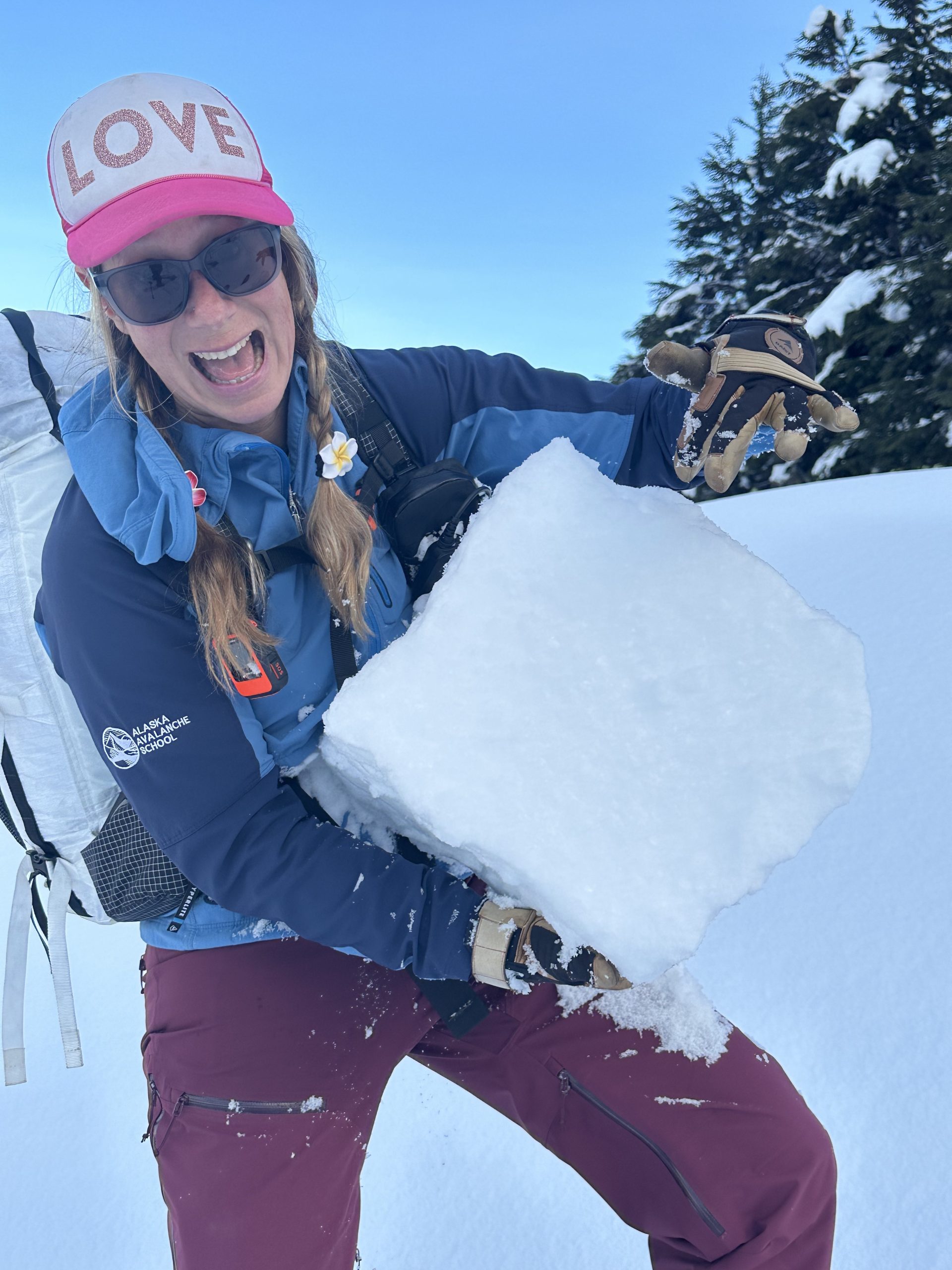
The multi-talented Brooke Edwards testing and identifying our problem layer of buried surface hoar in Turnagain Pass during an Alaska Guide Collective Rec Level 1 class on 01.28.2023.  If snowpack is the question, dialing back terrain choices to less than 30 degree slopes is the answer.

Avalanche Problem 2
  • Deep Persistent Slabs
    Deep Persistent Slabs
  • Aspect/Elevation
  • Almost Certain
    Very Likely
    Likely
    Possible
    Unlikely
    Likelihood
  • Historic (D4-5)
    Very Large (D3)
    Large (D2)
    Small (D1)
    Size
Deep Persistent Slabs
Deep Persistent Slab avalanches are the release of a thick cohesive layer of hard snow (a slab), when the bond breaks between the slab and an underlying persistent weak layer deep in the snowpack. The most common persistent weak layers involved in deep, persistent slabs are depth hoar or facets surrounding a deeply buried crust. Deep Persistent Slabs are typically hard to trigger, are very destructive and dangerous due to the large mass of snow involved, and can persist for months once developed. They are often triggered from areas where the snow is shallow and weak, and are particularly difficult to forecast for and manage.

Aspect/Elevation of the Avalanche Problem
Specialists develop a graphic representation of the potential distribution of a particular avalanche problem across the topography. This aspect/elevation rose is used to indicate where the particular avalanche problem is thought to exist on all elevation aspects. Areas where the avalanche problem is thought to exist are colored grey, and it is less likely to be encountered in areas colored white.

Likelihood of Avalanches
Terms such as "unlikely", "likely", and "certain" are used to define the scale, with the chance of triggering or observing avalanches increasing as we move up the scale. For our purposes, "Unlikely" means that few avalanches could be triggered in avalanche terrain and natural avalanches are not expected. "Certain" means that humans will be able to trigger avalanches on many slopes, and natural avalanches are expected.

Size of Avalanches
Avalanche size is defined by the largest potential avalanche, or expected range of sizes related to the problem in question. Assigned size is a qualitative estimate based on the destructive classification system and requires specialists to estimate the harm avalanches may cause to hypothetical objects located in the avalanche track (AAA 2016, CAA 2014). Under this schema, "Small" avalanches are not large enough to bury humans and are relatively harmless unless they carry people over cliffs or through trees or rocks. Moving up the scale, avalanches become "Large" enough to bury, injure, or kill people. "Very Large" avalanches may bury or destroy vehicles or houses, and "Historic" avalanches are massive events capable of altering the landscape.

Signal Word Size (D scale) Simple Descriptor
Small 1 Unlikely to bury a person
Large 2 Can bury a person
Very Large 3 Can destroy a house
Historic 4 & 5 Can destroy part or all of a village
More info at Avalanche.org

If you’ve been tuning in over the past several weeks, you know that we aren’t quite ready to ignore the facet/ crust combo affectionately referred to as the Thanksgiving Crust.  Now buried 4-8’ deep this is a high consequence, low probability avalanche problem at this point.  This layer is most problematic in areas with a thinner snowpack at elevations above 2500′. Although it is unlikely a person will trigger an avalanche on a layer that deep, the consequences of getting caught would likely be fatal.

Weather
Tue, January 31st, 2023

Yesterday: An overcast morning gave way to partly cloudy skies and even a little bit of sunshine by yesterday afternoon.  No new precipitation recorded with light winds out of the east gusting into the teens at ridgetops.  High temperatures were in the low 20’s F with overnight lows about the same at 3800’.  Closer to sea level temps were steady in the low to mid-30’s F.

Today: Another day of insignificant weather is on tap.  We can expect partly to mostly cloudy skies, light and variable winds at ridgetops and temperatures in the mid to high 20’s across the advisory area.

Tomorrow:  Temperatures are expected to cool slightly by tomorrow to the mid 20’s.  Winds will remain light from the east.  There is a chance for some precipitation across the eastern Kenai Peninsula by tomorrow afternoon/ evening and into Thursday.  This doesn’t look to be a significant snow producer but should support snow to sea level.

PRECIPITATION 24-hour data (6am – 6am)

Temp Avg (F) Snow (in) Water (in) Snow Depth (in)
Center Ridge (1880′) 31 0 0 64
Summit Lake (1400′) 28 0 0 35
Alyeska Mid (1700′) 31 0 0 65
Bear Valley – Portage (132′) 34 0 0

RIDGETOP 24-hour data (6am – 6am)

Temp Avg (F) Wind Dir Wind Avg (mph) Wind Gust (mph)
Sunburst (3812′) 22 E 5 22
Seattle Ridge (2400′) 26 SE 6 13
Observations
Recent Observations for Turnagain Pass
Date Region Location
03/30/23 Turnagain Observation: Magnum/Cornbiscuit
03/30/23 Turnagain Avalanche: Wolverine, West Flank
03/26/23 Turnagain Avalanche: Sunburst avalanche investigation
03/26/23 Turnagain Observation: Magnum shoulder
03/25/23 Turnagain Avalanche: Seattle Ridge backside – several human triggered large avalanches
03/25/23 Turnagain Avalanche: Seattle Ridge, 3rd Bowl, Rider Triggered Avalanches
03/25/23 Turnagain Avalanche: Pastoral
03/25/23 Turnagain Avalanche: Eddie’s
03/25/23 Turnagain Observation: Eddies lower slopes
03/25/23 Turnagain Observation: Sunny Side
Riding Areas
Updated Sat, April 01st, 2023

Status of riding areas across the Chugach NF is managed by the Glacier and Seward Ranger Districts, not avalanche center staff. Riding area information is posted as a public service to our users and updated based on snow depth and snow density to prevent resource damage at trailhead locations. Riding area questions contact: mailroom_r10_chugach@fs.fed.us

Area Status Weather & Riding Conditions
Glacier District
Johnson Pass
Open
Opened Dec 13th.
Placer River
Open
Closed Jan 5th due to lack of snow and reopened Feb 11th.
Skookum Drainage
Closed
Will close to motorized use on April 1, 2023 per the National Forest Plan.
Turnagain Pass
Open
Opened Dec 13th.
Twentymile
Open
Closed Jan 5th due to lack of snow and reopened Feb 11th.
Seward District
Carter Lake
Open
Opened Dec 13th.
Lost Lake Trail
Open
Opened Dec 13th.
Primrose Trail
Open
Opened Dec 13th.
Resurrection Pass Trail
Closed
Closed to motorized use for the 2022/23 winter season per Forest Plan. Open next season.
Snug Harbor
Open
Opened Dec 13th.
South Fork Snow River Corridor
Open
Opened Dec 13th.
Summit Lake
Open
Opened Dec 13th.

Subscribe to Turnagain Pass
Avalanche Forecast by Email

This is a general backcountry avalanche advisory issued for Turnagain Arm with Turnagain Pass as the core advisory area. This advisory does not apply to highways, railroads or operating ski areas.