Turnagain Pass Avalanche Forecast RSS

Archives
ARCHIVED FORECAST - All forecasts expire after 24 hours from the posting date/time.
Issued
Thu, January 30th, 2020 - 7:00AM
Expires
Fri, January 31st, 2020 - 7:00AM
Forecaster
Aleph Johnston-Bloom
Avalanche risk The Bottom Line

The avalanche danger is CONSIDERABLE at all elevations. Human triggered storm slab and loose snow avalanches remain likely today in steep terrain. Buried weak layers are now 2-3′ deep and avalanches have the potential to be large and dangerous. Careful route finding is essential.

SEWARD: This region also received new snow with wind. Caution is advised.

Special Announcements

From Alaska DOT & PF: Today there will be intermittent traffic delays for avalanche hazard reduction on the Seward Highway from mile post 82 to 89 South of Girdwood from 8:00 am to 2:00 PM.
There will also be delays on the Portage Glacier Highway on for avalanche hazard reduction near Mile Post 4 to Bear Valley from 12:00 Noon to 4:00 pm. Motorists should expect delays of 45 minutes to one hour. Updates will be posted on the 511 system.  http://511.alaska.gov/


Thanks to our sponsors!
Thu, January 30th, 2020
Alpine
Above 2,500'
Considerable (3)
Avalanche risk
Treeline
1,000'-2,500'
Considerable (3)
Avalanche risk
Below Treeline
Below 1,000'
Considerable (3)
Avalanche risk
Alpine
Above 2,500'
Avalanche risk
Considerable (3)
Treeline
1,000'-2,500'
Avalanche risk
Considerable (3)
Below Treeline
Below 1,000'
Avalanche risk
Considerable (3)
Danger Scale:
No Rating (0)
Low (1)
Moderate (2)
Considerable (3)
High (4)
Extreme (5)
Avalanche Problem 1
  • Storm Slabs
    Storm Slabs
  • Almost Certain
    Very Likely
    Likely
    Possible
    Unlikely
    Likelihood
  • Historic (D4-5)
    Very Large (D3)
    Large (D2)
    Small (D1)
    Size
Storm Slabs
Storm Slab avalanches are the release of a cohesive layer (a slab) of new snow that breaks within new snow or on the old snow surface. Storm-slabs typically last between a few hours and few days (following snowfall). Storm-slabs that form over a persistent weak layer (surface hoar, depth hoar, or near-surface facets) may be termed Persistent Slabs or may develop into Persistent Slabs.

Likelihood of Avalanches
Terms such as "unlikely", "likely", and "certain" are used to define the scale, with the chance of triggering or observing avalanches increasing as we move up the scale. For our purposes, "Unlikely" means that few avalanches could be triggered in avalanche terrain and natural avalanches are not expected. "Certain" means that humans will be able to trigger avalanches on many slopes, and natural avalanches are expected.

Size of Avalanches
Avalanche size is defined by the largest potential avalanche, or expected range of sizes related to the problem in question. Assigned size is a qualitative estimate based on the destructive classification system and requires specialists to estimate the harm avalanches may cause to hypothetical objects located in the avalanche track (AAA 2016, CAA 2014). Under this schema, "Small" avalanches are not large enough to bury humans and are relatively harmless unless they carry people over cliffs or through trees or rocks. Moving up the scale, avalanches become "Large" enough to bury, injure, or kill people. "Very Large" avalanches may bury or destroy vehicles or houses, and "Historic" avalanches are massive events capable of altering the landscape.

Signal Word Size (D scale) Simple Descriptor
Small 1 Unlikely to bury a person
Large 2 Can bury a person
Very Large 3 Can destroy a house
Historic 4 & 5 Can destroy part or all of a village
More info at Avalanche.org

New snow is so exciting but the snowpack needs time to adjust to the snow load. There are now three storms worth of snow sitting on the weak snow (facets and surface hoar) that formed over the long stretch of cold and clear weather. With the previous storms that buried the weak snow, the snow had not formed a slab and the snow was enjoyed without incident. Yesterday there were some storm ingredients that may have changed all that and increased the likelihood of triggering a large avalanche. Because of the additional snow, warming temperatures and sustained strong winds, 2-3′ thick slabs now sit over the buried weak layers just waiting for a trigger. This set-up must be guilty until proven innocent. Be on the lookout for signs of instability today. Have there been recent avalanches? There were some naturals observed yesterday. Are there shooting cracks from your skis or machine? An observer yesterday noted cracks shooting out 3 ft. Can you feel collapsing? Does the snow feel grabby or punchy (a sign of heavier snow over soft snow)? Can you see drifting and cornices? Is the snow wind effected? Slabs over facets and buried surface hoar also have the potential to be triggered remotely. What slopes are you traveling on and under? If you or your party gets stuck in the snow in avalanche terrain, don’t send another to dig out. The message today is choose your travel route carefully and be conservative. Don’t let the powder cloud your judgement! Today could be a good day to check out the snow at Alyeska or enjoy the powder in the Placer or Turnagain flats!

Loose snow avalanches: Observers yesterday noted deep snow, getting stuck and overall slow going. In areas where the snow remains protected and soft, loose snow avalanches are possible in steep terrain. These could be quite hazardous in terrain traps. Even a small avalanche could bury you deeply.

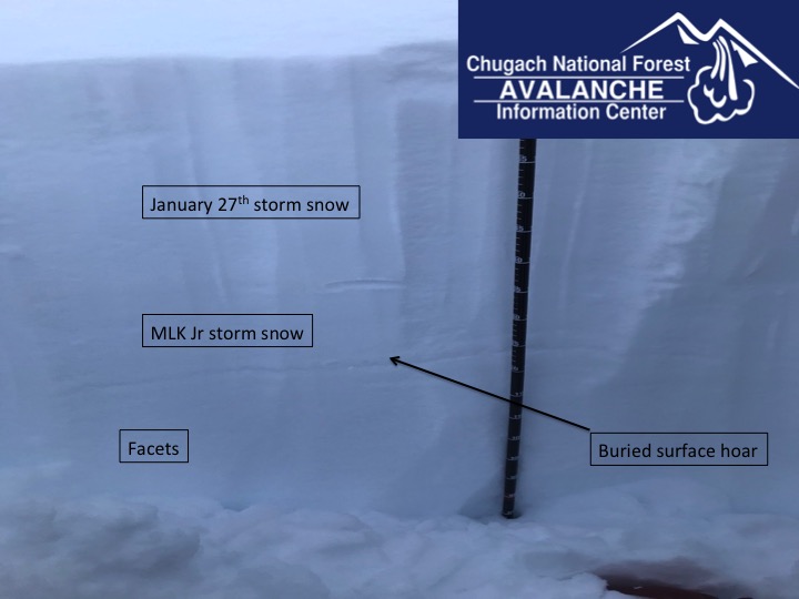
The snowpack at 2500′ on Tincan, 1.28.20. There is now another 1-2′ of snow on top of the buried weak layers. This is the concern today. 

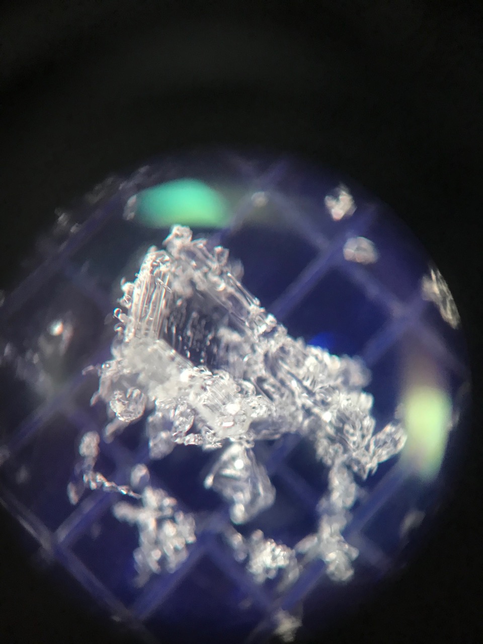
A closer look at the buried surface hoar. This delicate weak layer has the potential to be triggered and cause a large, dangerous avalanche today.

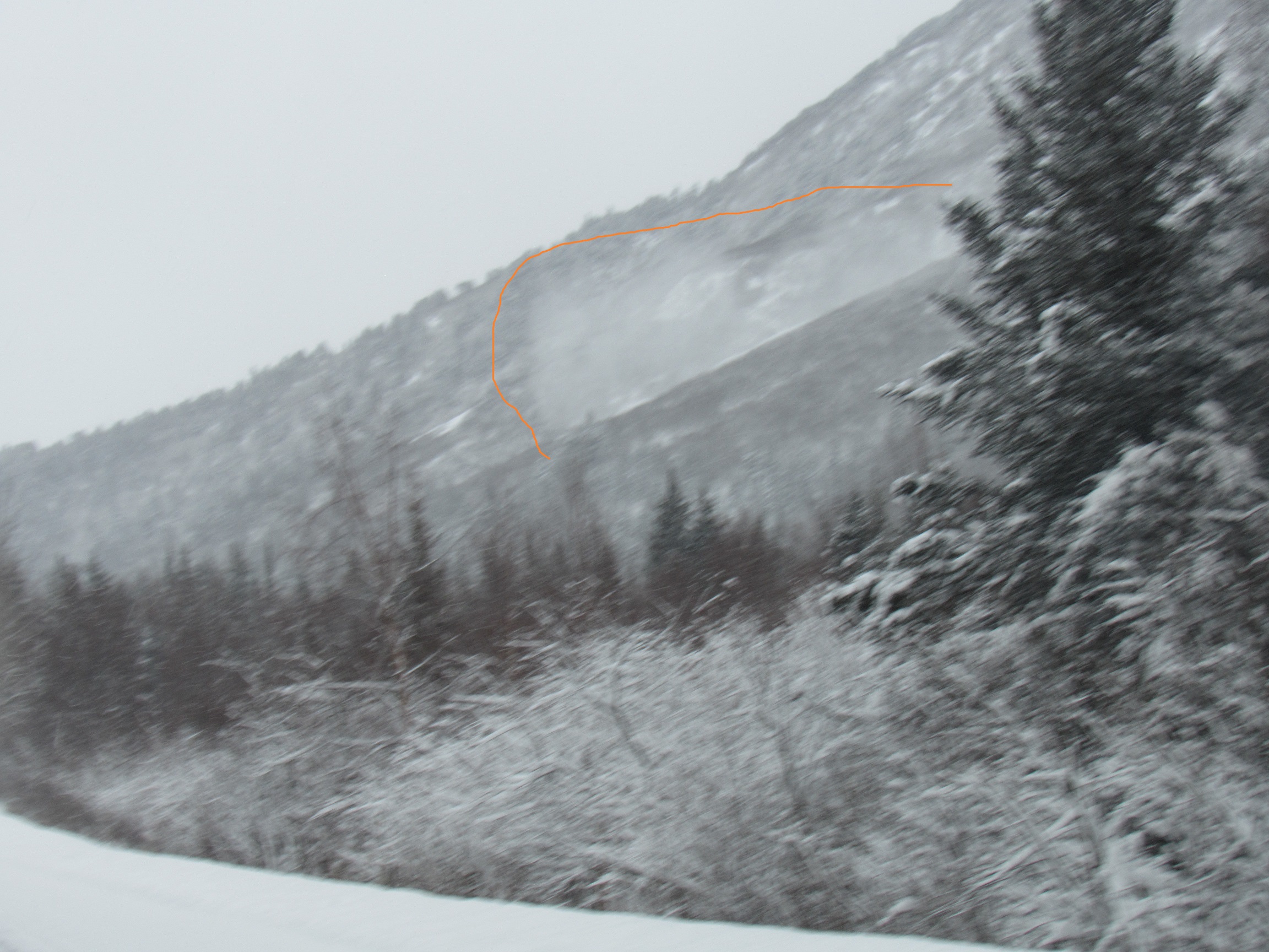
Powder cloud from a natural avalanche observed at 2 pm yesterday from the Johnson Pass South trailhead. Recent avalanches are an indication that the snowpack is unstable. 1.29.20. Photo: Alex McLain

Weather
Thu, January 30th, 2020

Yesterday: Snow fell throughout most of the day with showers continuing overnight with 5-10″ of accumulation. Easterly winds ramped up in the late afternoon blowing 20-30 mph and gusting into the 60s and 70s. Temperatures were in the teens to start and then rose into the 20Fs.

Today: Mostly cloudy skies with snow showers with the potential for a few inches of snow. Easterly winds will remain elevated this morning 10-20 mph with gusts into the 30s and become light this afternoon. Temperatures will be in the teens and low 20Fs.  Skies remain cloudy overnight with light snow showers, light winds and temperatures dip back down to the single digits.

Tomorrow: Scattered snow showers, mostly cloudy skies, light north winds and temperatures in the low teens. The cooling trend continues into Saturday and then temperatures warm again as the pattern changes into early next week. Stay tuned!

PRECIPITATION 24-hour data (6am – 6am)

Temp Avg (F) Snow (in) Water (in) Snow Depth (in)
Center Ridge (1880′) 21 5 .3 63
Summit Lake (1400′) 18 3 .1 21
Alyeska Mid (1700′) 21 9 .7 55

RIDGETOP 24-hour data (6am – 6am)

Temp Avg (F) Wind Dir Wind Avg (mph) Wind Gust (mph)
Sunburst (3812′) 14 NE 23 73
Seattle Ridge (2400′) 18 E 10 34
Observations
Recent Observations for Turnagain Pass
Date Region Location
05/22/23 Turnagain Avalanche: Tincan
05/12/23 Turnagain Avalanche: Tincan, Sunburst, Magnum, Cornbiscuit
05/07/23 Turnagain Observation: Tincan – Bear Tracks
05/05/23 Turnagain Observation: Seattle Ridge
05/02/23 Turnagain Observation: Cornbiscuit
05/02/23 Turnagain Observation: Seward Hwy Turnagain Pass
04/30/23 Turnagain Observation: Magnum
04/29/23 Turnagain Observation: Tincan
04/28/23 Turnagain Avalanche: Taylor Pass/Pastoral
04/28/23 Turnagain Avalanche: Tincan
Riding Areas
Updated Thu, June 01st, 2023

Status of riding areas across the Chugach NF is managed by the Glacier and Seward Ranger Districts, not avalanche center staff. Riding area information is posted as a public service to our users and updated based on snow depth and snow density to prevent resource damage at trailhead locations. Riding area questions contact: mailroom_r10_chugach@fs.fed.us

Area Status Weather & Riding Conditions
Glacier District
Johnson Pass
Closed
Closed May 15.
Placer River
Closed
Closed May 15.
Skookum Drainage
Closed
Will close to motorized use on April 1, 2023 per the National Forest Plan.
Turnagain Pass
Closed
Will close on June 1.
Twentymile
Closed
Scheduled closure May 1.
Seward District
Carter Lake
Closed
Scheduled closure May 1.
Lost Lake Trail
Closed
Scheduled closure May 1.
Primrose Trail
Closed
Scheduled closure May 1.
Resurrection Pass Trail
Closed
Closed to motorized use for the 2022/23 winter season per Forest Plan. Open next season.
Snug Harbor
Closed
Extended opening until May 15.
South Fork Snow River Corridor
Closed
Scheduled closure May 1.
Summit Lake
Closed
Scheduled closure May 1.

Subscribe to Turnagain Pass
Avalanche Forecast by Email

This is a general backcountry avalanche advisory issued for Turnagain Arm with Turnagain Pass as the core advisory area. This advisory does not apply to highways, railroads or operating ski areas.