Turnagain Pass Avalanche Forecast
|
![]() ![]() |
The avalanche danger is CONSIDERABLE above 2,500′. Human triggered avalanches 1-3′ deep on a layer of buried surface hoar remain likely. This type of weak layer can be remotely triggered from low angle slopes onto adjacent steeper terrain. It is also possible to trigger an avalanche on a deeper weak layer 4-8′ deep. We recommend sticking to low angle terrain to give our weak layers more time to heal.
Between 1,000-2,500′ the avalanche danger is MODERATE. Recent wet snow and rain on the surface at these elevations are adding strength to the snowpack. Toward the upper end of this elevation band human triggered avalanches are still possible. Below 1,000′ the avalanche danger is LOW.
No new avalanches were reported yesterday. We saw lots of roller balls and some small wet loose avalanches up to about 2500′ on the snow surface, which is an indication of rain or wet snow falling onto a dry snow surface. The last known avalanche on the 1/10 buried surface hoar was on Sunday, January 22nd.
Roller balls and some wet loose avalanches on steeper terrain yesterday, with the possibility of more to come with sunshine and warm temps expected over the next few days. Photo 1.25.23
Signal Word | Size (D scale) | Simple Descriptor |
Small | 1 | Unlikely to bury a person |
Large | 2 | Can bury a person |
Very Large | 3 | Can destroy a house |
Historic | 4 & 5 | Can destroy part or all of a village |
Our last round of precipitation had a pretty high snow line, with wet snow or rain falling up to about 2000′. While this did not do any favors for the skiing and riding conditions at lower elevations, it seems to have added some strength to the upper snowpack and put a damper on the reactivity of the 1/10 buried surface hoar layer. We did not see any new avalanche activity yesterday and for the first time in over a week did not have reactive results in our snow pit tests. However we were only able to check out conditions below 2000′, so it is safe to assume the weak layer is still reactive in upper elevation areas. This is an encouraging sign that conditions might gradually be getting more stable, but due to the track record of the 1/10 buried surface hoar we still think large human triggered avalanches 1-3′ deep are likely above 2000′ today.
We recommend continuing to stick to low angle terrain and being aware of steep slopes above you that could potentially be triggered remotely. It will take time for our weak layers to heal and the consequences of triggering an avalanche remain high due to the depth of the weak layer and potential for very wide propagation. Digging a snow pit is the best way to evaluate the buried surface hoar, but it is worth remembering that older persistent weak layers can tend to give false stable pit results. Which means you could get no propagation in your pit and still have the potential to trigger an avalanche on an adjacent slope.
In addition to our persistent slab problem there was enough wind at upper elevations yesterday to create fresh wind slabs, especially along ridgelines and cross loaded gullies. Wet Loose avalanches and roller balls were visible on a variety of aspects up to about 2500′ yesterday. We are getting to the time of year where if the sun comes out it can create wet loose avalanche conditions and trigger point releases in rocky terrain on steeper southern aspects. Cornices are also looking large on many of our upper elevation ridgelines and the sun can cause cornices to fall onto slopes below. Be aware of the potential for cornice fall if you are travelling underneath a large cornice that is getting direct sunlight.
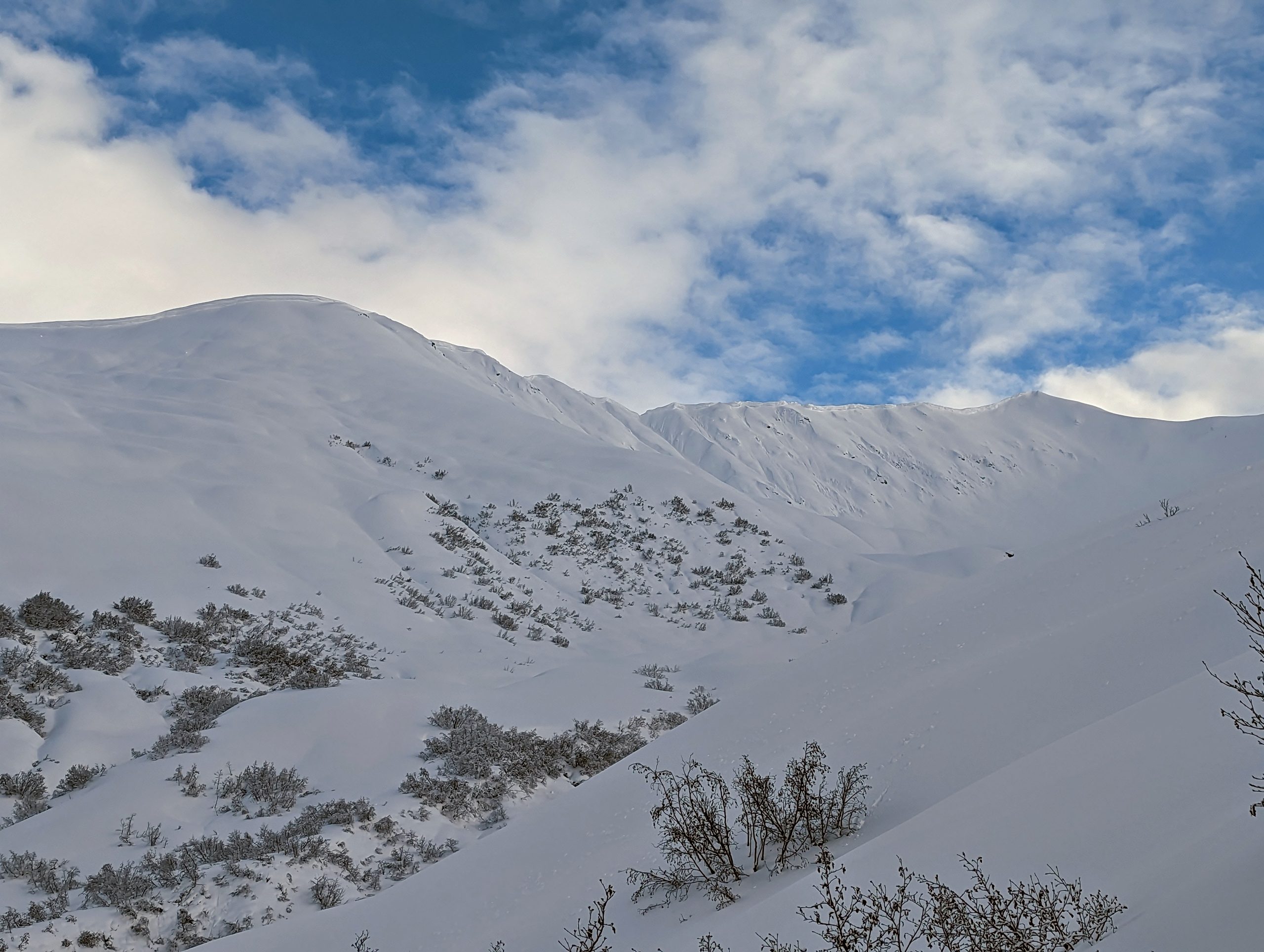
A new melt freeze crust at lower elevations is adding some strength to the upper snowpack. Photo 1.25.23
Large cornices along upper elevation ridgelines could become more of an issue with stronger solar input and mostly clear skies expected over the next few days. Photo 1.25.23
Signal Word | Size (D scale) | Simple Descriptor |
Small | 1 | Unlikely to bury a person |
Large | 2 | Can bury a person |
Very Large | 3 | Can destroy a house |
Historic | 4 & 5 | Can destroy part or all of a village |
We are still concerned about the same old Thanksgiving crust/facet combination producing very large avalanches at upper elevations. This weak snowpack structure still exists at the base of the snowpack and could produce an avalanche 4-8′ deep. Shallower avalanches like wind slabs or our buried surface hoar could step down to this deeper weak layer. This is yet another reason we are recommending a patient and cautious approach to travelling in the mountains right now. The consequences of being involved with one of these huge avalanches is just too high.
Yesterday: Snow and rain tapered off yesterday morning and cloud cover slowly lifted. By the afternoon skies were mostly sunny with patchy layers of valley fog. Moderate winds at upper elevations with averages of 5-15 mph and gusts up to 30 mph. Temperatures were warm, in the mid 30s at lower elevations and upper 20s at upper elevations. Snowline was around 1500-2000′ during the last storm.
Today: Sky cover should trend toward mostly sunny this afternoon with temperatures decreasing slightly to the low 30s at lower elevations and mid 20s at upper elevations as the skies clear. Wind speeds are also expected to decrease this morning to the 0-5 mph range with gusts up to 15 mph. Snow or rain showers are possible today but no significant accumulation is expected.
Tomorrow: Clearing skies and calm winds are expected to persist through the weekend. A temperature inversion is expected to develop Friday evening, with temperatures possibly reaching the low to mid 40s from 1500 – 5000′ from Friday evening through Sunday morning.
PRECIPITATION 24-hour data (6am – 6am)
Temp Avg (F) | Snow (in) | Water (in) | Snow Depth (in) | |
---|---|---|---|---|
Center Ridge (1880′) | 33 | 0 | 0.2 | 66 |
Summit Lake (1400′) | 32 | 0 | 0.1 | 34 |
Alyeska Mid (1700′) | 33 | 0 | 0.25 | 69.5 |
Bear Valley – Portage (132′) | 38 | 0 | 0.37 | 0 |
RIDGETOP 24-hour data (6am – 6am)
Temp Avg (F) | Wind Dir | Wind Avg (mph) | Wind Gust (mph) | |
---|---|---|---|---|
Sunburst (3812′) | 26 | ESE | 9 | 31 |
Seattle Ridge (2400′) | 29 | SE | 4.5 | 16 |
Date | Region | Location | Observer |
---|---|---|---|
03/30/23 | Turnagain | Observation: Magnum/Cornbiscuit | Schauer/ Slesser Forecaster |
03/30/23 | Turnagain | Avalanche: Wolverine, West Flank | James Howery |
03/26/23 | Turnagain | Avalanche: Sunburst avalanche investigation | Schauer/ Cullen Forecaster |
03/26/23 | Turnagain | Observation: Magnum shoulder | Matthew Howard |
03/25/23 | Turnagain | Avalanche: Seattle Ridge backside – several human triggered large avalanches | CNFAIC Staff |
03/25/23 | Turnagain | Avalanche: Seattle Ridge, 3rd Bowl, Rider Triggered Avalanches | CNFAIC Staff |
03/25/23 | Turnagain | Avalanche: Pastoral | Tony Naciuk |
03/25/23 | Turnagain | Avalanche: Eddie’s | James Howery |
03/25/23 | Turnagain | Observation: Eddies lower slopes | Anna Frick Bridget Psarianos |
03/25/23 | Turnagain | Observation: Sunny Side | Peter Wadsworth |
Status of riding areas across the Chugach NF is managed by the Glacier and Seward Ranger Districts, not avalanche center staff. Riding area information is posted as a public service to our users and updated based on snow depth and snow density to prevent resource damage at trailhead locations. Riding area questions contact: mailroom_r10_chugach@fs.fed.us
Area | Status | Weather & Riding Conditions |
---|---|---|
Glacier District |
Subscribe to Turnagain Pass
Avalanche Forecast by Email
This is a general backcountry avalanche advisory issued for Turnagain Arm with Turnagain Pass as the core advisory area. This advisory does not apply to highways, railroads or operating ski areas.