Turnagain Pass Avalanche Forecast RSS

Archives
ARCHIVED FORECAST - All forecasts expire after 24 hours from the posting date/time.
Issued
Wed, January 22nd, 2020 - 7:00AM
Expires
Thu, January 23rd, 2020 - 7:00AM
Forecaster
Wendy Wagner
Avalanche risk The Bottom Line

The avalanche danger remains MODERATE above 1,000′. Triggering a shallow soft slab avalanche is possible where Monday’s snow is more cohesive due to past wind and/or warmer temperatures. Loose snow sluffs are expected to be easy to trigger on steep slopes. These could entrain a significant amount of snow and create a larger avalanche than expected. Although the danger is LOW below 1,000′, small sluffs are possible.

SUMMIT LAKE: This region is just out of our advisory area to the south. The snowpack is shallow and extra caution is advised for triggering a slab avalanche in buried weak layers.

Thanks to our sponsors!
Wed, January 22nd, 2020
Alpine
Above 2,500'
Moderate (2)
Avalanche risk
Treeline
1,000'-2,500'
Moderate (2)
Avalanche risk
Below Treeline
Below 1,000'
Low (1)
Avalanche risk
Alpine
Above 2,500'
Avalanche risk
Moderate (2)
Treeline
1,000'-2,500'
Avalanche risk
Moderate (2)
Below Treeline
Below 1,000'
Avalanche risk
Low (1)
Danger Scale:
No Rating (0)
Low (1)
Moderate (2)
Considerable (3)
High (4)
Extreme (5)
Avalanche Problem 1
  • Persistent Slabs
    Persistent Slabs
  • Almost Certain
    Very Likely
    Likely
    Possible
    Unlikely
    Likelihood
  • Historic (D4-5)
    Very Large (D3)
    Large (D2)
    Small (D1)
    Size
Persistent Slabs
Persistent Slab avalanches are the release of a cohesive layer of snow (a slab) in the middle to upper snowpack, when the bond to an underlying persistent weak layer breaks. Persistent layers include: surface hoar, depth hoar, near-surface facets, or faceted snow. Persistent weak layers can continue to produce avalanches for days, weeks or even months, making them especially dangerous and tricky. As additional snow and wind events build a thicker slab on top of the persistent weak layer, this avalanche problem may develop into a Deep Persistent Slab.

Likelihood of Avalanches
Terms such as "unlikely", "likely", and "certain" are used to define the scale, with the chance of triggering or observing avalanches increasing as we move up the scale. For our purposes, "Unlikely" means that few avalanches could be triggered in avalanche terrain and natural avalanches are not expected. "Certain" means that humans will be able to trigger avalanches on many slopes, and natural avalanches are expected.

Size of Avalanches
Avalanche size is defined by the largest potential avalanche, or expected range of sizes related to the problem in question. Assigned size is a qualitative estimate based on the destructive classification system and requires specialists to estimate the harm avalanches may cause to hypothetical objects located in the avalanche track (AAA 2016, CAA 2014). Under this schema, "Small" avalanches are not large enough to bury humans and are relatively harmless unless they carry people over cliffs or through trees or rocks. Moving up the scale, avalanches become "Large" enough to bury, injure, or kill people. "Very Large" avalanches may bury or destroy vehicles or houses, and "Historic" avalanches are massive events capable of altering the landscape.

Signal Word Size (D scale) Simple Descriptor
Small 1 Unlikely to bury a person
Large 2 Can bury a person
Very Large 3 Can destroy a house
Historic 4 & 5 Can destroy part or all of a village
More info at Avalanche.org

Skies are clearing this morning and today should be the first good visibility day since the MLK Jr. storm on Monday. Roughly a foot of low-density snow fell in the higher alpine from that storm with a few inches of new snow from yesterday’s instability showers. Winds along the peaks have remained light over the past several days and despite the incoming cold temperatures, powder seekers are sure to get out.

With that said, the main avalanche concerns center around Monday’s snow: how well it is sticking together (forming a slab), its bonding with the old weak snow underneath, and if it’s just loose and sluffs are a concern (more on that below). Not only does a thick layer of faceted snow sit under Monday’s snow, but even older weak faceted snow sits under the wind crusts and slabs from the long dry spell. Although unlikely, an avalanche triggered in the recent storm snow could step down and pull out a deeper slab. This is most suspect in high elevation steep terrain.

How to watch for soft slabs:

  • Slopes where the new foot of snow is more cohesive and stiffer, possibly cracking around you
  • Whumpfing sounds – one person reported some whumpfing at treeline on Tincan yesterday
  • Areas where the snow saw enough wind to form a soft wind slab

Simply being observant along with quick hand pits are great ways to assess this issue. Compression tests are not always conclusive as the snow can be too soft.

Monday’s  10″ of snow on the Eddies westerly slopes. It was not quite enough to hide the old tracks from the cold/dry spell. 1.20.20. Photo: Heather Thamm.

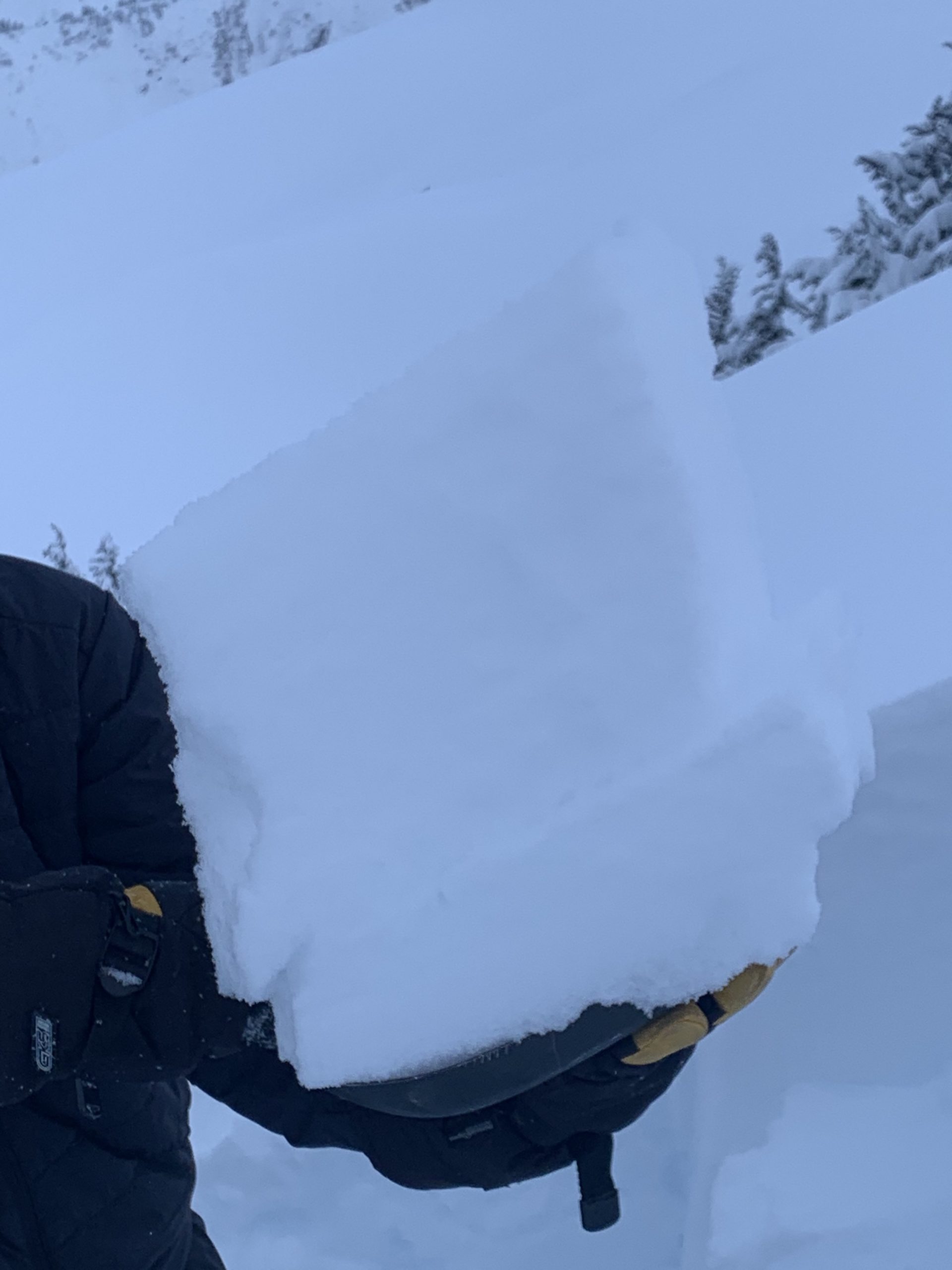
Another shot of Monday’s snow that is still very loose and not acting like a slab in many areas. 1.20.20. Photo: Heather Thamm

Avalanche Problem 2
  • Dry Loose
    Dry Loose
  • Almost Certain
    Very Likely
    Likely
    Possible
    Unlikely
    Likelihood
  • Historic (D4-5)
    Very Large (D3)
    Large (D2)
    Small (D1)
    Size
Dry Loose
Dry Loose avalanches are the release of dry unconsolidated snow and typically occur within layers of soft snow near the surface of the snowpack. These avalanches start at a point and entrain snow as they move downhill, forming a fan-shaped avalanche. Other names for loose-dry avalanches include point-release avalanches or sluffs.

Likelihood of Avalanches
Terms such as "unlikely", "likely", and "certain" are used to define the scale, with the chance of triggering or observing avalanches increasing as we move up the scale. For our purposes, "Unlikely" means that few avalanches could be triggered in avalanche terrain and natural avalanches are not expected. "Certain" means that humans will be able to trigger avalanches on many slopes, and natural avalanches are expected.

Size of Avalanches
Avalanche size is defined by the largest potential avalanche, or expected range of sizes related to the problem in question. Assigned size is a qualitative estimate based on the destructive classification system and requires specialists to estimate the harm avalanches may cause to hypothetical objects located in the avalanche track (AAA 2016, CAA 2014). Under this schema, "Small" avalanches are not large enough to bury humans and are relatively harmless unless they carry people over cliffs or through trees or rocks. Moving up the scale, avalanches become "Large" enough to bury, injure, or kill people. "Very Large" avalanches may bury or destroy vehicles or houses, and "Historic" avalanches are massive events capable of altering the landscape.

Signal Word Size (D scale) Simple Descriptor
Small 1 Unlikely to bury a person
Large 2 Can bury a person
Very Large 3 Can destroy a house
Historic 4 & 5 Can destroy part or all of a village
More info at Avalanche.org

Watch your sluff on steep sustained slopes. With a foot of loose snow over another foot of loose faceted older snow, sluffs have the potential to gain volume and run further than expected. They could gouge into the older snow and end up depositing a large amount of debris. The cold temperatures that moved in overnight and forecast for the next few days will only make the snow looser and exacerbate the issue.

Cornices and Glide Cracks:  As always, give cornices a wide berth and limit exposure under glide cracks.

Weather
Wed, January 22nd, 2020

Yesterday:  Cloudy skies along with some instability snow showers were over the region. Between 3-4″ of low-density snow fell in Girdwood, Portage Valley and other favored areas while Turnagain Pass saw 1-2″ of new snow. Ridgetop winds were light and variable before turning to the northwest around midnight. Temperatures hit a high in the high teens to low 20’s°F at all elevations before cooling overnight.

Today:  Mostly sunny skies are on tap for today as cold air spills in from the northwest. Temperatures have already dropped to the single digits above 3,500′ this morning and should hover near 0°F tonight. At the lower elevations, temperatures are still in the teens and should also slowly continue to cool. Ridgetop winds are light from the northwest currently and are forecast to remain light, 5-10mph, today.

Tomorrow:  Cold and mostly clear sky weather is expected into the weekend. The not-so-great news is that an increase in northwest wind is forecast with an outflow wind event setting up for Thursday night through Friday. Stay tuned.

PRECIPITATION 24-hour data (6am – 6am)

Temp Avg (F) Snow (in) Water (in) Snow Depth (in)
Center Ridge (1880′) 17 1-2 0.1 43
Summit Lake (1400′) 13 trace trace 16
Alyeska Mid (1700′) 15 2 0.2 47

RIDGETOP 24-hour data (6am – 6am)

Temp Avg (F) Wind Dir Wind Avg (mph) Wind Gust (mph)
Sunburst (3812′) 13 variable 3 7
Seattle Ridge (2400′) 15 variable 2 9
Observations
Recent Observations for Turnagain Pass
Date Region Location
05/22/23 Turnagain Avalanche: Tincan
05/12/23 Turnagain Avalanche: Tincan, Sunburst, Magnum, Cornbiscuit
05/07/23 Turnagain Observation: Tincan – Bear Tracks
05/05/23 Turnagain Observation: Seattle Ridge
05/02/23 Turnagain Observation: Cornbiscuit
05/02/23 Turnagain Observation: Seward Hwy Turnagain Pass
04/30/23 Turnagain Observation: Magnum
04/29/23 Turnagain Observation: Tincan
04/28/23 Turnagain Avalanche: Taylor Pass/Pastoral
04/28/23 Turnagain Avalanche: Tincan
Riding Areas
Updated Sat, September 23rd, 2023

Status of riding areas across the Chugach NF is managed by the Glacier and Seward Ranger Districts, not avalanche center staff. Riding area information is posted as a public service to our users and updated based on snow depth and snow density to prevent resource damage at trailhead locations. Riding area questions contact: mailroom_r10_chugach@fs.fed.us

Area Status Weather & Riding Conditions
Glacier District
Johnson Pass
Closed
Scheduled opening per Chugach National Forest plan December 1. Subject to adequate snow cover.
Placer River
Closed
Scheduled opening per Chugach National Forest plan December 1. Subject to adequate snow cover.
Skookum Drainage
Closed
Scheduled opening per Chugach National Forest plan December 1. Subject to adequate snow cover.
Turnagain Pass
Closed
Scheduled opening on the Wednesday before Thanksgiving per Chugach National Forest plan. Subject to adequate snow cover.
Twentymile
Closed
Scheduled opening per Chugach National Forest plan December 1. Subject to adequate snow cover.
Seward District
Carter Lake
Closed
Scheduled opening per Chugach National Forest plan December 1. Subject to adequate snow cover.
Lost Lake Trail
Closed
Scheduled opening per Chugach National Forest plan December 1. Subject to adequate snow cover.
Primrose Trail
Closed
Scheduled opening per Chugach National Forest plan December 1. Subject to adequate snow cover.
Resurrection Pass Trail
Closed
Scheduled opening per Chugach National Forest plan December 1. Subject to adequate snow cover.
Snug Harbor
Closed
Scheduled opening per Chugach National Forest plan December 1. Subject to adequate snow cover.
South Fork Snow River Corridor
Closed
Scheduled opening per Chugach National Forest plan December 1. Subject to adequate snow cover.
Summit Lake
Closed
Scheduled opening per Chugach National Forest plan December 1. Subject to adequate snow cover.

Subscribe to Turnagain Pass
Avalanche Forecast by Email

This is a general backcountry avalanche advisory issued for Turnagain Arm with Turnagain Pass as the core advisory area. This advisory does not apply to highways, railroads or operating ski areas.