Turnagain Pass RSS

Archives
ARCHIVED - Forecasts expire after 24 hours.
Issued
Fri, January 13th, 2023 - 7:00AM
Expires
Sat, January 14th, 2023 - 7:00AM
Forecaster
John Sykes
Avalanche risk The Bottom Line

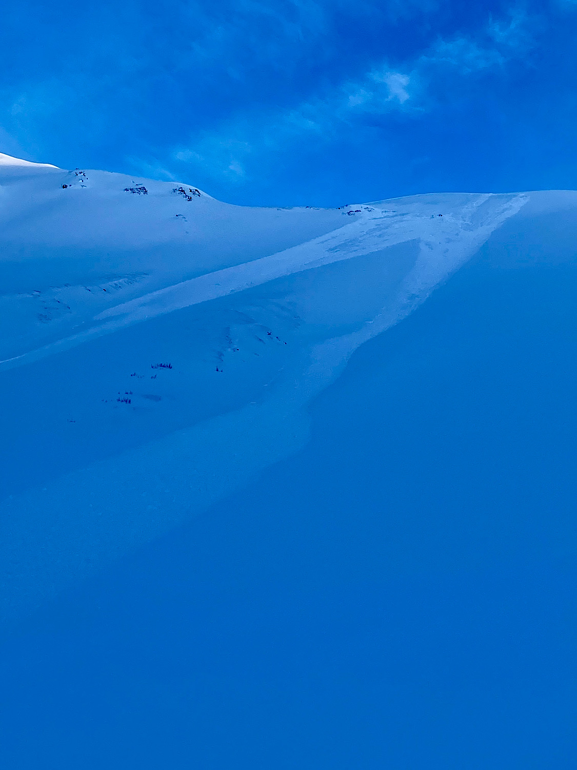
The avalanche danger remains MODERATE above 1000′. Triggering a very large avalanche 3-6′ deep on a buried weak layer is still possible. Remote triggering one of these avalanches is also possible, which means you could trigger an avalanche from low angle terrain onto steeper slopes above, to the sides, or below where you are travelling. In addition, shallow surface avalanches 6-12″ deep and up to several hundred feet wide are likely for human triggering today. Below 1000′ the avalanche danger is LOW.

Special Announcements

Alaska Avalanche School has several slots open in their upcoming Motorized Avalanche Rescue course in Turnagain Pass on January 15th. This is a great affordable opportunity to invest in your own skills and knowledge to help keep yourself and your partners safe in avalanche terrain!

Forecaster Chat #2:  Join us at the Girdwood Brewing Co. from 5:30-7:00 p.m. on Thursday, Jan. 19! CNFAIC forecaster Andrew Schauer will open the night with an overview of the state of the snowpack, followed by a discussion on how safe terrain management changes depending on the type of avalanche problem at hand. More details here.

Fri, January 13th, 2023
Alpine
Above 2,500'
2 - Moderate
Avalanche risk
Treeline
1,000'-2,500'
2 - Moderate
Avalanche risk
Below Treeline
Below 1,000'
1 - Low
Avalanche risk
0 - No Rating
1 - Low
2 - Moderate
3 - Considerable
4 - High
5 - Extreme
Avalanche risk Avalanche risk Avalanche risk Avalanche risk Avalanche risk
Travel Advice Generally safe avalanche conditions. Watch for unstable snow on isolated terrain features. Heightened avalanche conditions on specific terrain features. Evaluate snow and terrain carefully; identify features of concern. Dangerous avalanche conditions. Careful snowpack evaluation, cautious route-finding, and conservative decision-making essential. Very dangerous avalanche conditions. Travel in avalanche terrain not recommended. Extraordinarily dangerous avalanche conditions. Avoid all avalanche terrain.
Likelihood of Avalanches Natural and human-triggered avalanches unlikely. Natural avalanches unlikely; human-triggered avalanches possible. Natural avalanches possible; human-triggered avalanches likely. Natural avalanches likely; human-triggered avalanches very likely. Natural and human-triggered avalanches certain.
Avalanche Size and Distribution Small avalanches in isolated areas or extreme terrain. Small avalanches in specific areas; or large avalanches in isolated areas. Small avalanches in many areas; or large avalanches in specific areas; or very large avalanches in isolated areas. Large avalanches in many areas; or very large avalanches in specific areas. Very large avalanches in many areas.
Recent Avalanches

We got reports of widespread natural and human triggered surface avalanches yesterday that are occurring at the interface of the new snow from Tuesday night. This new snow fell on top of surface hoar and near surface facets in many areas and is producing reactive surface slabs 6-12″ deep. Larger avalanches up to 20″ deep have been observed in areas that received more new snow, like near Portage/Placer and other coastal areas.

Sunburst, Turnagain Pass

This avalanche on Sunburst near Taylor Pass was only 8″ deep but it propagated 200′ wide and ran far down slope (D 1.5). Photo from Anonymous 1.12.23

Avalanche Problem 1
  • Deep Persistent Slabs
    Deep Persistent Slabs
  • Aspect/Elevation
  • Certain
    Very Likely
    Likely
    Possible
    Unlikely
    Likelihood
  • Historic (D4-5)
    Very Large (D3)
    Large (D2)
    Small (D1)
    Size
Deep Persistent Slabs
Deep Persistent Slab avalanches are the release of a thick cohesive layer of hard snow (a slab), when the bond breaks between the slab and an underlying persistent weak layer deep in the snowpack. The most common persistent weak layers involved in deep, persistent slabs are depth hoar or facets surrounding a deeply buried crust. Deep Persistent Slabs are typically hard to trigger, are very destructive and dangerous due to the large mass of snow involved, and can persist for months once developed. They are often triggered from areas where the snow is shallow and weak, and are particularly difficult to forecast for and manage.

Aspect/Elevation of the Avalanche Problem
Specialists develop a graphic representation of the potential distribution of a particular avalanche problem across the topography. This aspect/elevation rose is used to indicate where the particular avalanche problem is thought to exist on all elevation aspects. Areas where the avalanche problem is thought to exist are colored grey, and it is less likely to be encountered in areas colored white.

Likelihood of Avalanches
Terms such as "unlikely", "likely", and "certain" are used to define the scale, with the chance of triggering or observing avalanches increasing as we move up the scale. For our purposes, "Unlikely" means that few avalanches could be triggered in avalanche terrain and natural avalanches are not expected. "Certain" means that humans will be able to trigger avalanches on many slopes, and natural avalanches are expected.

Size of Avalanches
Avalanche size is defined by the largest potential avalanche, or expected range of sizes related to the problem in question. Assigned size is a qualitative estimate based on the destructive classification system and requires specialists to estimate the harm avalanches may cause to hypothetical objects located in the avalanche track (AAA 2016, CAA 2014). Under this schema, "Small" avalanches are not large enough to bury humans and are relatively harmless unless they carry people over cliffs or through trees or rocks. Moving up the scale, avalanches become "Large" enough to bury, injure, or kill people. "Very Large" avalanches may bury or destroy vehicles or houses, and "Historic" avalanches are massive events capable of altering the landscape.

Signal Word Size (D scale) Simple Descriptor
Small 1 Unlikely to bury a person
Large 2 Can bury a person
Very Large 3 Can destroy a house
Historic 4 & 5 Can destroy part or all of a village
More info at Avalanche.org

Our main concern continues to be the possibility of another very large human triggered avalanche on a deeply buried weak layer of facets above the Thanksgiving crust. This layer is buried 3-6′ deep in most areas and has shown the potential for very wide propagation across multiple terrain features. This avalanche problem is also prime for remote triggering an avalanche from lower angle terrain onto steeper slopes above, to the sides, or below where you are travelling. The most likely place to trigger an avalanche on a deeply buried weak layer is from a thin spot in the snowpack, like where rocks penetrate part way through the snowpack or wind scouring has made the total snow depth shallower in specific areas. We recommend sticking to smaller terrain features, low angle slopes, and being aware of any steep slopes overhead if you are travelling above 2500′.

Avalanche Problem 2
  • Wind Slabs
    Wind Slabs
  • Aspect/Elevation
  • Certain
    Very Likely
    Likely
    Possible
    Unlikely
    Likelihood
  • Historic (D4-5)
    Very Large (D3)
    Large (D2)
    Small (D1)
    Size
Wind Slabs
Wind Slab avalanches are the release of a cohesive layer of snow (a slab) formed by the wind. Wind typically transports snow from the upwind sides of terrain features and deposits snow on the downwind side. Wind slabs are often smooth and rounded and sometimes sound hollow, and can range from soft to hard. Wind slabs that form over a persistent weak layer (surface hoar, depth hoar, or near-surface facets) may be termed Persistent Slabs or may develop into Persistent Slabs.

Aspect/Elevation of the Avalanche Problem
Specialists develop a graphic representation of the potential distribution of a particular avalanche problem across the topography. This aspect/elevation rose is used to indicate where the particular avalanche problem is thought to exist on all elevation aspects. Areas where the avalanche problem is thought to exist are colored grey, and it is less likely to be encountered in areas colored white.

Likelihood of Avalanches
Terms such as "unlikely", "likely", and "certain" are used to define the scale, with the chance of triggering or observing avalanches increasing as we move up the scale. For our purposes, "Unlikely" means that few avalanches could be triggered in avalanche terrain and natural avalanches are not expected. "Certain" means that humans will be able to trigger avalanches on many slopes, and natural avalanches are expected.

Size of Avalanches
Avalanche size is defined by the largest potential avalanche, or expected range of sizes related to the problem in question. Assigned size is a qualitative estimate based on the destructive classification system and requires specialists to estimate the harm avalanches may cause to hypothetical objects located in the avalanche track (AAA 2016, CAA 2014). Under this schema, "Small" avalanches are not large enough to bury humans and are relatively harmless unless they carry people over cliffs or through trees or rocks. Moving up the scale, avalanches become "Large" enough to bury, injure, or kill people. "Very Large" avalanches may bury or destroy vehicles or houses, and "Historic" avalanches are massive events capable of altering the landscape.

Signal Word Size (D scale) Simple Descriptor
Small 1 Unlikely to bury a person
Large 2 Can bury a person
Very Large 3 Can destroy a house
Historic 4 & 5 Can destroy part or all of a village
More info at Avalanche.org

Our two avalanche problems are on opposite ends of the size spectrum right now. On the one hand it is quite likely you could encounter a wind slab or storm slab 6-12″ deep that will be easy to trigger due to a layer of buried surface hoar and near surface facets underneath. So far these avalanches have not been large enough to bury a person in our core forecast area, but have been quite sensitive and producing wider than normal propagation and long runouts for such shallow slabs. On the other hand triggering a 3-6′ deep avalanche on the Thanksgiving facet/crust combo is less likely but the consequences are so severe that we are keeping it as problem 1 for now.

It is possible that a smaller surface avalanche could trigger a much deeper avalanche but due to the low volume of these surface avalanches it seems like an outside chance for now. As we start to get more snow over the weekend the size of these surface slabs will increase, making them more dangerous on their own and more likely to step down and trigger a deeper avalanche. You are most likely to trigger a surface avalanche in wind loaded areas where the new snow formed into a more connected and stronger slab, such as along ridgelines and cross loaded gully features.

This is the layer of large surface hoar that is causing the new storm snow to be so reactive in many areas. Photo 1.6.23

Weather
Fri, January 13th, 2023

Yesterday: Mostly calm weather with light winds and no significant precipitation. Coastal areas, like near Portage, received up to 1″ of snowfall. Temperatures remain in the mid to low thirties at sea level and in the twenties at higher elevations. Wind speeds averaged 0-10 mph with gusts up to 20 mph. Cloud cover was in and out throughout the day with denser clouds near the coast.

Today: Friday should be very similar to Thursday and will be the last calm weather day before we shift into a wetter pattern over the weekend. Temperatures should remain in the low to mid thirties at sea level and twenties at upper elevations. Wind speeds will remain at 0-10 mph during the day. Later this evening wind speeds are expected to increase slightly to the 5-15 mph range and light snowfall may start overnight.

Tomorrow:  Light snowfall is expected throughout the day on Saturday with a strong gradient in snowfall amounts from coastal to more interior areas. Girdwood and Turnagain Pass should expect between 1-3″ of snow on Saturday with Portage likely receiving closer to 6-12″ of snowfall. Snowline should be between 500-1000′ on Saturday. The wetter weather pattern should continue through early next week.

PRECIPITATION 24-hour data (6am – 6am)

Temp Avg (F) Snow (in) Water (in) Snow Depth (in)
Center Ridge (1880′) 30 0 0 60
Summit Lake (1400′) 23 0 0 32
Alyeska Mid (1700′) 30 0 0 53
Bear Valley – Portage (132′) 32 1 0.1

RIDGETOP 24-hour data (6am – 6am)

Temp Avg (F) Wind Dir Wind Avg (mph) Wind Gust (mph)
Sunburst (3812′) 24 NE 7 21
Seattle Ridge (2400′) 28 SE 1 7

* Seattle Ridge has been reporting wind speeds sporadically, likely due to riming on the wind speed sensor.

Observations
Recent Observations for Turnagain Pass
Date Region Location
03/28/24 Turnagain Observation: Sunburst
03/27/24 Turnagain Observation: Tincan Trees
03/26/24 Turnagain Observation: Cornbiscuit
03/25/24 Turnagain Observation: Tincan
03/22/24 Turnagain Avalanche: Magnum Northwest Aspect
03/21/24 Turnagain Observation: Sunburst
03/21/24 Turnagain Observation: Tincan Proper North Aspect
03/20/24 Turnagain Avalanche: Seattle Creek Drainage
03/19/24 Turnagain Observation: Tincan CFR
03/18/24 Turnagain Avalanche: Tincan – Eddies – Seattle Ridge
Riding Areas

The riding areas page has moved. Please click here & update your bookmarks.


Subscribe to Turnagain Pass
Avalanche Forecast by Email

This is a general backcountry avalanche advisory issued for Turnagain Arm with Turnagain Pass as the core advisory area. This advisory does not apply to highways, railroads or operating ski areas.