Turnagain Pass Avalanche Forecast
|
![]() ![]() |
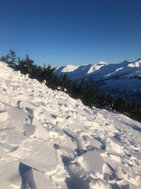
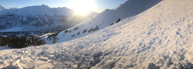
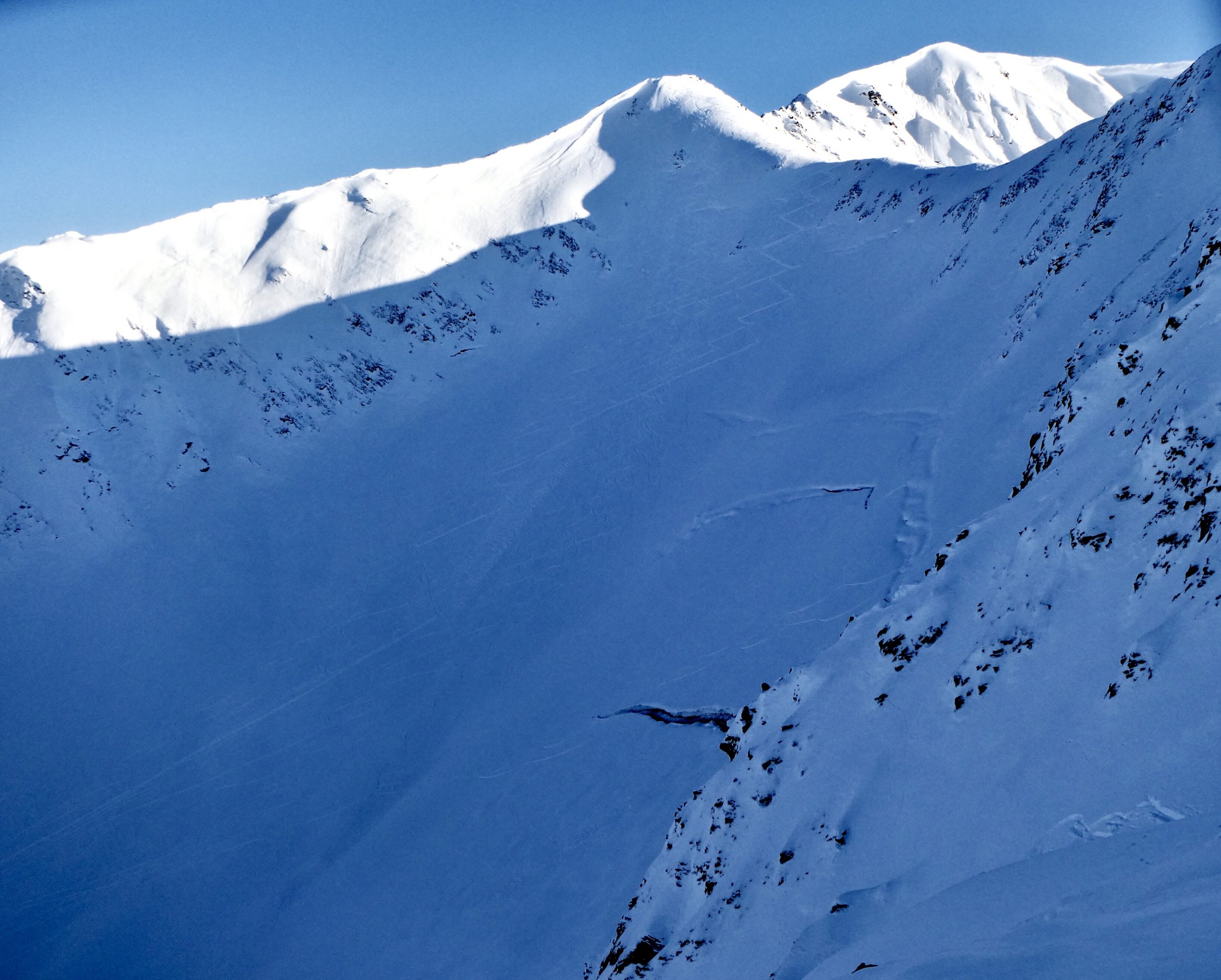
Above 1000′, the avalanche danger remains MODERATE. Triggering a wind slab in wind loaded terrain or a sluff on steep protected slopes is possible. In addition, there is the potential to trigger a large avalanche on a weak layer buried 1-3′ deep. Give cornices a wide berth and limit exposure under glide cracks.
*Friday afternoon there was a near miss avalanche incident along the Crow Pass summer hiking trail. We are currently compiling a near miss report and would like to thank the party involved for sharing their information. We are extremely thankful everyone is OK.
Monday night: Join CNFAIC’s Aleph Johnston-Bloom at the Sitzmark at Alyeska Resort on January 13th at 7pm for an evening of discussing Alaskan avalanche accidents and avalanche awareness. Thanks to Alyeska, Powderhound and the Sitzmark who will be hosting and providing avalanche rescue gear giveaways! Details HERE. See you there!
Signal Word | Size (D scale) | Simple Descriptor |
Small | 1 | Unlikely to bury a person |
Large | 2 | Can bury a person |
Very Large | 3 | Can destroy a house |
Historic | 4 & 5 | Can destroy part or all of a village |
Light to moderate winds have been over the region for the past several days. They were consistently moderate last night and are forecast to continue today. Combine these wind speeds with unconsolidated surface snow throughout the region, and the potential for wind slabs to form in the lee of ridges and gullies also increases. Additionally, finding and triggering an older wind slab is possible. These slabs could be sitting on weak faceted snow, which can make them easier to trigger. Watch for blowing snow and changing surface conditions today. Look for visual signs that slopes have been loaded by the winds, these often have a rounded shape and will likely exist in the lee aspects. The snow may feel stiffer, hollow and crack around you. These are all signs of a potential wind slab.
Recent wind slab avalanche at 2700′ on east aspect of Colorado peak. Suspected skier trigger from previous 1-2 days. 1.11.2020. Photo: Anonymous
Signal Word | Size (D scale) | Simple Descriptor |
Small | 1 | Unlikely to bury a person |
Large | 2 | Can bury a person |
Very Large | 3 | Can destroy a house |
Historic | 4 & 5 | Can destroy part or all of a village |
Faceted weak layers and a layer of buried surface hoar remain within the snowpack. We’ve found these layers mostly 1-3 feet deep and showing signs that they are becoming harder to trigger with time. Signs of instability are not usually present before a slope releases in this case and many tracks can be on a slope before someone finds a trigger point. Thin areas in the snowpack are the most likely places to trigger a slide, they are often near rocks and on top of rollovers. As always, good travel practices are in order: watching our partners, expose only one person at a time, remaining aware of consequences if the slope does slide, and choosing up and down tracks with forethought.
Glide cracks continue to ooze open. We haven’t seen or received reports of glide avalanches, yet they remain an unpredictable. Travel advice remains the same: limit your exposure while traveling near and underneath glide cracks.
Loose snow sluffs: On slopes out of the wind the surface snow is becoming looser and looser by the day with the cold temperatures. Sluffs are getting larger because of this and gaining volume in longer sustained slopes. One observer described almost having a close call with his sluff on Friday. The faceting is more pronounced at lower elevations. Expect larger sluffs in steep terrain.
Cornices: Give cornices plenty of space and limit your exposure when passing beneath them.
PRECIPITATION 24-hour data (6am – 6am)
Yesterday: Mostly clear and cold. A temperature inversion caused higher elevation temperatures to range from 5-10°F, while the valley bottoms -25 to -10°F. Ridgetop winds were from the northwest between 5-10mph with gust into the teens.
Today: As a front pushes through the region, cloudy skies will prevail with warmer temperatures and a few snow flurries. Only a trace to 3″ of snow is expected along with temperatures in the teens and a period of increased easterly winds, 10-20 mph with gusts into the 30s. A return to cold and clear weather is expected tomorrow and into next week.
Tomorrow: Mostly cloudy skies trend to become clear, with temperatures falling back to single digits. Northwest wind 10 to 15 mph.
Temp Avg (F) | Snow (in) | Water (in) | Snow Depth (in) | |
---|---|---|---|---|
Center Ridge (1880′) | 7 | 0 | 0 | 38 |
Summit Lake (1400′) | -6 | 0 | 0 | 14 |
Alyeska Mid (1700′) | 7 | 0 | 0 | 33 |
RIDGETOP 24-hour data (6am – 6am)
Temp Avg (F) | Wind Dir | Wind Avg (mph) | Wind Gust (mph) | |
---|---|---|---|---|
Sunburst (3812′) | 9 | VAR | 8 | 19 |
Seattle Ridge (2400′) | 9 | E | 7 | 18 |
Date | Region | Location | Observer |
---|---|---|---|
05/22/23 | Turnagain | Avalanche: Tincan | Nick D'Alessio |
05/12/23 | Turnagain | Avalanche: Tincan, Sunburst, Magnum, Cornbiscuit | Heather Thamm |
05/07/23 | Turnagain | Observation: Tincan – Bear Tracks | CNFAIC Staff |
05/05/23 | Turnagain | Observation: Seattle Ridge | AS/ WW Forecaster |
05/02/23 | Turnagain | Observation: Cornbiscuit | Schauer/ Sturgess Forecaster |
05/02/23 | Turnagain | Observation: Seward Hwy Turnagain Pass | Joel Curtis |
04/30/23 | Turnagain | Observation: Magnum | Ayla, Kit Crosby, Barton |
04/29/23 | Turnagain | Observation: Tincan | John Sykes |
04/28/23 | Turnagain | Avalanche: Taylor Pass/Pastoral | Schauer/ Creighton Forecaster |
04/28/23 | Turnagain | Avalanche: Tincan | Andy Moderow |
Status of riding areas across the Chugach NF is managed by the Glacier and Seward Ranger Districts, not avalanche center staff. Riding area information is posted as a public service to our users and updated based on snow depth and snow density to prevent resource damage at trailhead locations. Riding area questions contact: mailroom_r10_chugach@fs.fed.us
Area | Status | Weather & Riding Conditions |
---|---|---|
Glacier District |
Subscribe to Turnagain Pass
Avalanche Forecast by Email
This is a general backcountry avalanche advisory issued for Turnagain Arm with Turnagain Pass as the core advisory area. This advisory does not apply to highways, railroads or operating ski areas.