Turnagain Pass Avalanche Forecast
|
![]() ![]() |
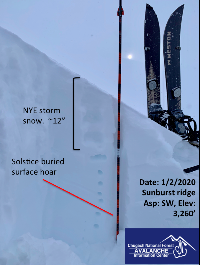
A MODERATE avalanche danger exists at and above treeline where it remains possible to trigger an avalanche breaking on a buried weak layer in the snowpack. Loose snow, lingering wind slabs and precarious cornices should also be on your avalanche radar. With several motorized areas opening today, terrain progression and good travel protocol will be the name of the game.
Below treeline the danger is LOW.
Several areas across the Chugach National Forest open to over snow vehicles today. DOT is still working on plowing roads and parking lots. Please avoid parking in areas that will impede their progress to clear snow from the NYE storm. Reference the “Riding Areas” tab on this page for the latest info.
Signal Word | Size (D scale) | Simple Descriptor |
Small | 1 | Unlikely to bury a person |
Large | 2 | Can bury a person |
Very Large | 3 | Can destroy a house |
Historic | 4 & 5 | Can destroy part or all of a village |
Forecasters and observers are continuing to consistently find a layer of buried surface hoar in our snowpack across the advisory area. After the storm on New Years Eve that deposited 12-24”+ of low-density snow, this layer is anywhere from 18” -36” deep. It tends to be shallower on the south end of Turnagain Pass and likely easier to trigger. Triggering an avalanche on this buried surface hoar layer remains a possibility today and may not be prefaced by any red flags. Ask yourself the question: If this slope does slide, what are the consequences?
Clear skies, quality snow and a motorized opener today will have skiers and snowmachiners pushing into new terrain today that hasn’t seen any traffic or slope testers this season. Keep terrain progression on you mind and don’t let your personal human factors get the best of you. Furthermore, expose only one person at a time and be mindful of where you’re at in relation to other groups as you travel through avalanche terrain today.
Signal Word | Size (D scale) | Simple Descriptor |
Small | 1 | Unlikely to bury a person |
Large | 2 | Can bury a person |
Very Large | 3 | Can destroy a house |
Historic | 4 & 5 | Can destroy part or all of a village |
Dry unconsolidated storm snow and cold temps have us thinking about sluff management. Clearing skies yesterday allowed observers to spot a handful of loose snow avalanches in steep terrain, including on the front face of Seattle Ridge. Be mindful and cognizant of consequences if you were to get knocked off your feet by a fast moving sluff in steep terrain.
Wind slabs: Lingering wind slabs from the NYE storm may be found today below ridge lines and in cross-loaded gullies. Additionally, given the low-density surface snow, even light winds yesterday and today (15-20mph) could build fresh wind slabs.
Cornices: Wet snow and wind in the Alpine during the warm part of Tuesday’s storm added snow/ weight to precarious cornices in the Alpine. Avoid travel on or underneath these backcountry bombs and pay attention to groups traveling above or below you.
Corniced ridge above Sunburst’s SW face yesterday. photo: Paul Wunnicke
Yesterday: Partly cloudy skies and a few hours of instability showers thru Turnagain Pass led to about an inch of accumulation. Temperatures were hovering around 0 degrees F at 1,000’ and winds were generally light, but kicked up from the NE around 2pm where ridgetop locations saw gusts into the 30’s mph.
Today: Partly sunny skies and cold temps are on tap. Temperatures will be in the single digits and winds light from the North with no new precip expected. Isolated areas may see gusty NNE winds as interior high pressure sets up. Generally the thought is these outflow winds should stay to our east today with the greatest impact to the Copper River Basin and Thompson Pass.
Tomorrow: Mostly sunny skies, light winds and high temperatures that are not likely to climb out of the single digits. Bundle up, get outside and enjoy that mid-winter light!
PRECIPITATION 24-hour data (6am – 6am)
Temp Avg (F) | Snow (in) | Water (in) | Snow Depth (in) | |
---|---|---|---|---|
Center Ridge (1880′) | 6 | 1 | .1 | 43 |
Summit Lake (1400′) | -1 | 0 | 0 | 15 |
Alyeska Mid (1700′) | 8 | 3 | .41 | 38 |
RIDGETOP 24-hour data (6am – 6am)
Temp Avg (F) | Wind Dir | Wind Avg (mph) | Wind Gust (mph) | |
---|---|---|---|---|
Sunburst (3812′) | 0 | ENE | 11 | 37 |
Seattle Ridge (2400′) | 4 | n/a | n/a | n/a |
Date | Region | Location | Observer |
---|---|---|---|
05/22/23 | Turnagain | Avalanche: Tincan | Nick D'Alessio |
05/12/23 | Turnagain | Avalanche: Tincan, Sunburst, Magnum, Cornbiscuit | Heather Thamm |
05/07/23 | Turnagain | Observation: Tincan – Bear Tracks | CNFAIC Staff |
05/05/23 | Turnagain | Observation: Seattle Ridge | AS/ WW Forecaster |
05/02/23 | Turnagain | Observation: Cornbiscuit | Schauer/ Sturgess Forecaster |
05/02/23 | Turnagain | Observation: Seward Hwy Turnagain Pass | Joel Curtis |
04/30/23 | Turnagain | Observation: Magnum | Ayla, Kit Crosby, Barton |
04/29/23 | Turnagain | Observation: Tincan | John Sykes |
04/28/23 | Turnagain | Avalanche: Taylor Pass/Pastoral | Schauer/ Creighton Forecaster |
04/28/23 | Turnagain | Avalanche: Tincan | Andy Moderow |
Status of riding areas across the Chugach NF is managed by the Glacier and Seward Ranger Districts, not avalanche center staff. Riding area information is posted as a public service to our users and updated based on snow depth and snow density to prevent resource damage at trailhead locations. Riding area questions contact: mailroom_r10_chugach@fs.fed.us
Area | Status | Weather & Riding Conditions |
---|---|---|
Glacier District |
Subscribe to Turnagain Pass
Avalanche Forecast by Email
This is a general backcountry avalanche advisory issued for Turnagain Arm with Turnagain Pass as the core advisory area. This advisory does not apply to highways, railroads or operating ski areas.