Near Miss: Turnagain
Location: Tincan Proper
EVENTS
A group of skiers and splitboaders were hiking up the last steep pitch ascending Tincan Proper when the person at the front of the group triggered a large avalanche that ran to the valley floor. Here is a brief summary from the person that triggered the avalanche:
“100 feet from the summit of Tincan Proper we encountered a supportable crust on a steep pitch. I made 2 steps onto the crust and broke through on my third step. I heard a loud whumph and immediately stepped back 2 paces behind a rock pillar. The wind slab (2’ at the crown and 5’ deep at the center of the concavity) slid down the north chute 2000’ to the valley floor. The cornice connected to the wind slab also simultaneously broke and went tumbling down the south gulley. If I had been a few more paces out on the wind slab I likely would have been carried down the north chute 2000’ to the valley floor.”
Luckily the rest of the group was also off of the moving slab, and nobody was caught or carried in the avalanche. Another group witnessed the event from lower down along the Tincan Ridgeline, and saw multiple shooting cracks propagating on what they suspected was a layer of facets on top of a crust that had formed roughly 4 weeks prior. A quick hand pit confirmed their suspicions. A third party was on the next ridgeline to the north of the avalanche and was able to snap a photo of the crown just after the avalanche happened.
AVALANCHE INFORMATION
Type: Hard Slab
Problem/Character: Persistent Slab
Crown Thickness: 2-5 feet
Width: 200 feet
Vertical Run: 2000 feet
Trigger: Foot penetration
Weak Layer: Suspected near-surface facets on top of a crust
Aspect: NW
Elevation: 3,700 feet
Slope Angle: 35 degrees
Discussion: The weather events leading up to this avalanche extend back to the end of December, when a warm storm brought rain as high as 7000′. Temperatures dropped during the days following the storm, forming a crust that covered slopes up to the highest ridgelines in the area. Light snowfall on Dec. 31 covered this crust with 3-5″ of low density snow. Cold and clear weather persisted for the first week of January, with high temperatures struggling to make it above single digits F, and overnight lows below 0 F between Jan. 1 and Jan. 5. This facilitated near-surface faceting, forming the weak layer that ultimately failed in this avalanche. Moderate winds shifted from westerly to northerly to easterly during the dry spell, redistributing some of the soft snow above the crust, resulting in high variability in the distribution of the weak snow when it was covered by a series of heavy snowfall events between Jan. 10 and Jan. 14.
Avalanche danger remained elevated following the storm, staying at CONSIDERABLE in the alpine (above 2500′) from Jan. 14-Jan. 16. This was partly due to the high uncertainty concerning the facets on top of the New Year’s crust. Skies finally cleared January 16 and 17, allowing CNFAIC forecasters and large numbers of recreationists to access the alpine with very few signs of instability related to the buried persistent weak layer. There were 11 observations submitted to our website over these two days, with only one showing signs of instability related to the layer in question. The observation came from Raggedtop- a high elevation peak on the northern edge of the CNFAIC advisory area- and noted shooting cracks that we suspect were propagating along the same facets that facilitated this avalanche.
One noteworthy observation from this avalanche is the relatively shallow depth to the New Year’s facets on the slope that failed. The avalanche was only 2-5′ deep, despite receiving over 4′ of snow with strong winds during the previous week. This suggests that the slope that failed had either been scoured by strong winds at some point during the recent storms, or that it avalanched mid-storm and reloaded. We suspect the shallow burial depth was a key factor that allowed a person to trigger the avalanche.
WEATHER
Turnagain Pass received another 6-8″ snow with light winds between Jan. 18 and 19, leaving plenty of snow available for transport as winds ramped up during the day on Jan. 20. Winds arrived sooner than expected on the day of the near-miss, with multiple observers noting flagging along the high peaks and ridges near the Turnagain Arm and Turnagain pass in the morning. Winds continued to increase during the day, with sustained speeds of 15-20 mph and gusts of 25-30 mph between 10:00 a.m. and 2:00 p.m.
AVALANCHE DANGER
The avalanche danger was rated MODERATE at all elevations, with the expectation that danger would rise to CONSIDERABLE as winds increased later in the day ahead of an approaching storm. The bottom line stated: “The avalanche danger will start out MODERATE today but will rapidly rise to CONSIDERABLE with the onset of strong winds this afternoon or early evening…once the winds pick up to 10-30 mph with gusts into the 60s, natural avalanches will be possible and human triggered avalanches will be likely up to 3′ deep in areas with active wind loading”. The full forecast is available HERE.
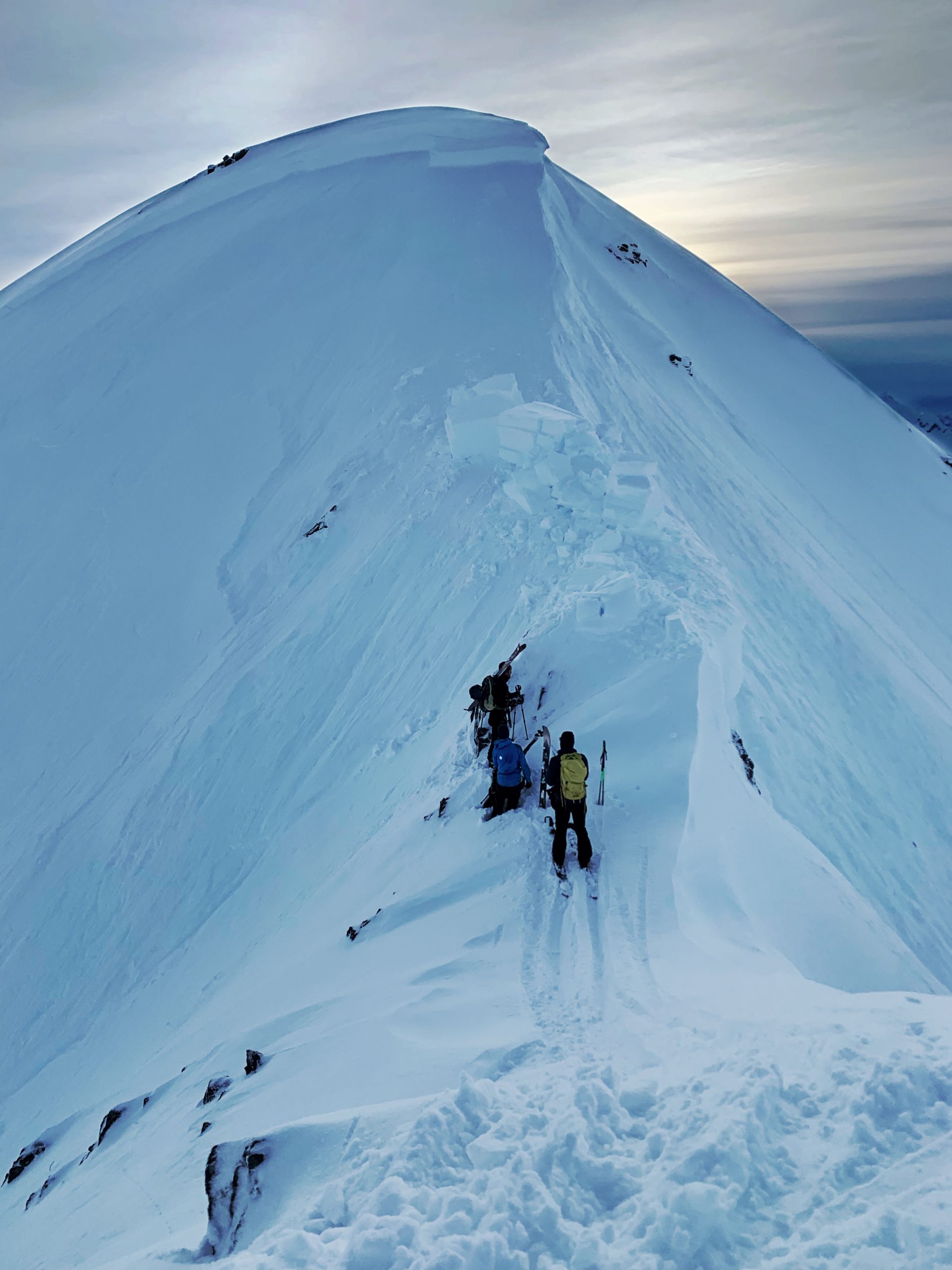
View of the crown from behind where the avalanche was triggered.

View of the crown from close to where the avalanche was triggered
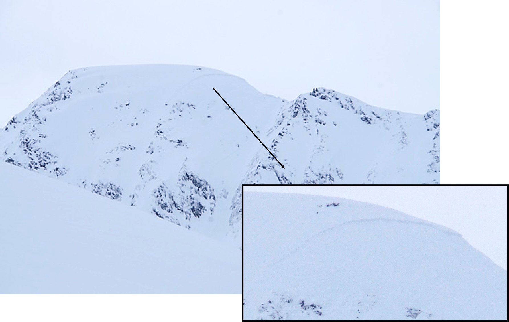
View of the crown as seen from Eddie's shortly after the avalanche occurred.

Map of the location of the avalanche. Tincan is situated at the top of Turnagian Pass, roughly 10 miles south of Girdwood as the crow flies.

Zoomed in view of the terrain where the avalanche occurred.