No cracking, collapsing or observed releases.
Rapid loading (S2-S5) from 9:30-4pm
Observation: Turnagain
Location: Tincan- above treeline
9:30-3:45pm
We took the standard approach to open north facing slopes above treeline and conducted instability tests at our high point of 2,400ft.
We encountered increasing wind L->S) and snow rate (S2->S5), with steady temps just below freezing and obscured skies throughout our tour. Tincan was plowed, but Sunburst and Eddies were not.
Wide skis help.
Observer Comments
Weather
Obscured skies with valley fog (1,200 ft-2,100 ft)
S2-S5 with most obvious increase by 1pm
Light E winds trending to strong E winds by 1pm.
Strong southerly gusts were inconsistent but reached approx. 35mph for 10-20 second intervals.
-5°C to -2°C @ 2,400 ft.
Snow surface
Fresh, low density precip particles 2-4mm with active riming.
A right side up accumulation of approx 18cm of fresh, was consistent between 1,500 ft to 2,400 ft.
Wind effect was strong within exposed terrain with HS 100-210cm in varying terrain.
Tree and alders above 2,200 ft were actively losing accumulation due to increasing winds.
Snowpack
In general, our focus was to assess recent accumulation above treeline.
We conducted instability tests with mixed results and identified the basal facet layer below the MF crust, still, as our layer of concern.
Our tests showed moderate structure, moderate strength, and fair propagation propensity.
The recent accumulation of 18cm is showing a fairly cohesive bond to the old interface within large column tests, but is fairly poor in burp, hand and CT.
We felt the 2cm thick melt-freeze crust may possibly be bridging the basal facets and depth hoar within large column testing, but collapsed within small column tests of fair results.
Overall, I believe we are seeing false-stability rising until a new load from this incoming storm produces some activity.
*See Hardness Profile and SnowPilot for Details*
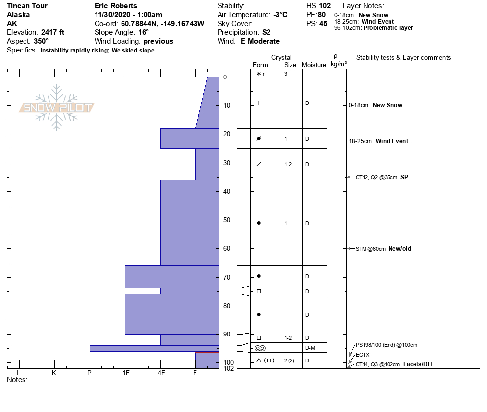
SnowPilot of Test Pit

Tincan. Still finding weak snow near the ground at Turnagain. Photo: Eric Roberts. 11.30.2020

Advanced Facets with depth hoar at base of Profile (2,400 ft)