| Recent Avalanches? | Yes |
| Collapsing (Whumphing)? | No |
| Cracking (Shooting cracks)? | No |
Observation: Turnagain
Location: Tincan
Toured up to Common Bowl and skied in the clouds. Wet snow at the parking lot got drier with elevation, although surface snow stayed moist all the way up to at least 3100′ elevation. Settled storm snow since Monday was around 4-6″ wet snow near the road to 20″ dry snow at 2700′, and as much as 30″ by 3100′. All of that soft snow will be a big concern as temperatures continue to heat up and skies clear this weekend.
We noticed a large glide avalanche in the Skookum drainage on our way back to town. Photos attached.
Obvious signs of instability
Observer Comments
We saw a lot of recent avalanche activity following the storms from this week. Some wet loose, and some storm slabs on Seattle Ridge. The bigger ones were D2's (big enough to bury a person). Visibility was good enough to note fresh debris piles below the north side of Sunburst, but it was difficult to say if they were loose snow avalanches or storm slabs. Likely a combination of both.
Weather
Light easterly winds with warm temperatures. Brief windows of sun poking through the clouds lured us up to Common Bowl, but of course the clouds filled in as soon as we got to the top.
Snow surface
Very wet up to 1700', enough to make it difficult to ski. Moist from 1700'-3100'. Storm totals since Monday were around 6" near the road, 12" at 2000', 20" at 2700', and 30" at 3100'. The new snow at 3100' was most likely wind-loaded, but storm totals could have brought around 2' of snow this week.
Snowpack
We dug multiple rapid pits on our way up to get a look at liquid water content as we gained elevation. Here's what we found:
Pit 1 (1350'):
Very wet snow down 12", with a layer of wet clustered rounds at 6" depth. Total new snow 4-6".
Pit 2 (1700'):
Wet down 2", with moist snow for the next 10". Total new snow 10-12", sitting on top of a melt-freeze crust. Difficult to shear the storm snow off the crust.
Pits 3 and 4 (2000'):
Moist snow for upper inch, with dry snow below. Melt-freeze crust down around 10", with another 6" soft snow (from 4/12) below the crust. Roughly 16" soft, dry snow near the surface that has fallen since 4/12.
Pits 4 and 5 (2700'):
Moist snow for upper inch, with a dusting of dry snow on top. 12" of dry snow on top of a melt-freeze crust, with another 10" of dry, soft snow below the melt-freeze crust. Roughly 22" soft, dry snow near the surface since 4/12.
Pole probes at 3100':
Approximately 30" new snow sitting on a firm older wind surface.
The biggest concern is all of the soft snow sitting on top of firm surfaces as we enter a warm and sunny period over the weekend. It is looking like we may have the potential for some large and/or widespread activity as the snowpack heats up.

Recent avalanche activity on Seattle Ridge. Likely occurred within past 3 days. 04.15.2021

Closeup of the Skookum glide avalanche. 04.15.2021
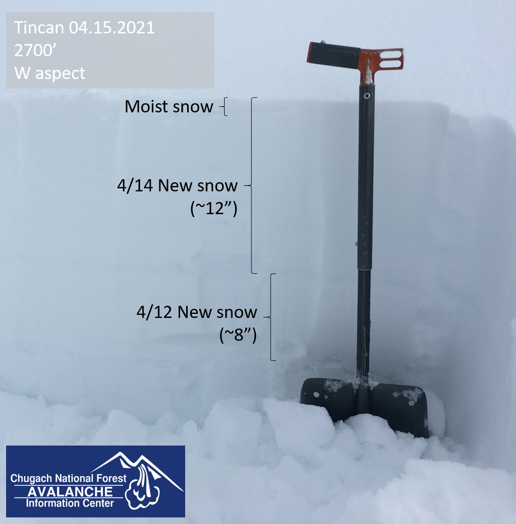
Quick snowpit in the surface snow at 2700'. 04.15.2021

Sorry about dragging you up there Adam... (He's in that picture somewhere). 04.15.2021