Partly cloudy, light wind, 32 deg F at parking lot.
Observation:
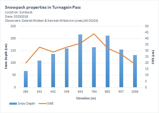
Location: Sunburst
We toured up the common up-track and measured snowpack depth and snow water equivalence (SWE) every ~100 m elevation gain, starting at 284m (932ft) and ending at 1056m (3465ft). See results in graph below.
Weather
Snow surface
Trace of new snow (< 1cm at parking lot, up to 10cm at 3400ft) on top of melt-freeze crust.
We got a few soft turns in the upper elevations thanks to overnight new snow that got baked in the sun. Mid and lower elevations were more challenging as the sun didn't thaw the melt-freeze crust.
Snowpack
We found the deepest snowpack at Taylor Creek bench and up towards the ridge. Note that we only measured snow depth and SWE along the ridge > 865m (2838ft) which is wind-affected. We expect the snowpack to be deeper on the S-SW aspects.
Sunburst_03292018_Elev_SD_SWE