Turnagain Pass RSS

Archives
ARCHIVED - Forecasts expire after 24 hours.
Issued
Sun, December 30th, 2018 - 7:00AM
Expires
Mon, December 31st, 2018 - 7:00AM
Forecaster
Wendy Wagner
Avalanche risk The Bottom Line

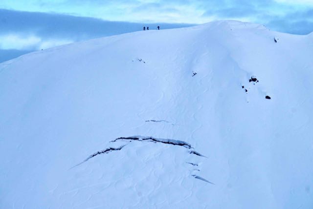
Strong wind with snowfall today, plus heavy snowfall tonight, will increase the avalanche danger to CONSIDERABLE through the day and may reach HIGH danger by early tomorrow morning. Wind slabs are forming now and may release naturally and storm snow avalanches will become likely once snowfall rates pick up. Timing for naturally occurring avalanches depends on the storm. Careful terrain selection as well as snowpack and weather evaluation in necessary if traveling into the backcountry.  A MODERATE danger exists below treeline where avalanches occurring above may send debris.

SUMMIT LAKE / JOHNSON PASS / LYNX DRAINAGE:    South of Turnagain Pass, new snow and wind may overload weak layers near the ground and larger avalanches may occur with this storm.  

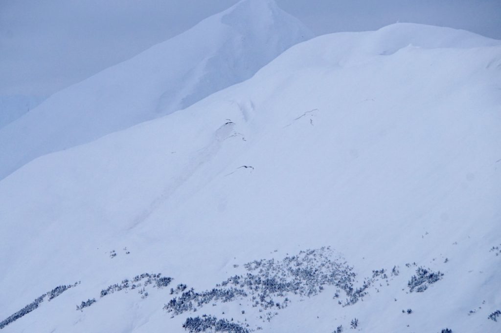
PORTAGE and PLACER VALLEY:   Heavier snowfall rates are expected and large avalanches above treeline may send debris to sea level and over summer hiking trails such as Byron Glacier Trail.

Special Announcements

If you are considering Hatcher Pass today, PLEASE check HPAC’s  Saturday avalanche forecast. A close call occurred at Hatcher  on Friday and tricky snowpack conditions exist, report HERE.  

Sun, December 30th, 2018
Alpine
Above 2,500'
3 - Considerable
Avalanche risk
Treeline
1,000'-2,500'
3 - Considerable
Avalanche risk
Below Treeline
Below 1,000'
2 - Moderate
Avalanche risk
0 - No Rating
1 - Low
2 - Moderate
3 - Considerable
4 - High
5 - Extreme
Avalanche risk Avalanche risk Avalanche risk Avalanche risk Avalanche risk
Travel Advice Generally safe avalanche conditions. Watch for unstable snow on isolated terrain features. Heightened avalanche conditions on specific terrain features. Evaluate snow and terrain carefully; identify features of concern. Dangerous avalanche conditions. Careful snowpack evaluation, cautious route-finding, and conservative decision-making essential. Very dangerous avalanche conditions. Travel in avalanche terrain not recommended. Extraordinarily dangerous avalanche conditions. Avoid all avalanche terrain.
Likelihood of Avalanches Natural and human-triggered avalanches unlikely. Natural avalanches unlikely; human-triggered avalanches possible. Natural avalanches possible; human-triggered avalanches likely. Natural avalanches likely; human-triggered avalanches very likely. Natural and human-triggered avalanches certain.
Avalanche Size and Distribution Small avalanches in isolated areas or extreme terrain. Small avalanches in specific areas; or large avalanches in isolated areas. Small avalanches in many areas; or large avalanches in specific areas; or very large avalanches in isolated areas. Large avalanches in many areas; or very large avalanches in specific areas. Very large avalanches in many areas.
Avalanche Problem 1
  • Storm Slabs
    Storm Slabs
  • Certain
    Very Likely
    Likely
    Possible
    Unlikely
    Likelihood
  • Historic (D4-5)
    Very Large (D3)
    Large (D2)
    Small (D1)
    Size
Storm Slabs
Storm Slab avalanches are the release of a cohesive layer (a slab) of new snow that breaks within new snow or on the old snow surface. Storm-slabs typically last between a few hours and few days (following snowfall). Storm-slabs that form over a persistent weak layer (surface hoar, depth hoar, or near-surface facets) may be termed Persistent Slabs or may develop into Persistent Slabs.

Likelihood of Avalanches
Terms such as "unlikely", "likely", and "certain" are used to define the scale, with the chance of triggering or observing avalanches increasing as we move up the scale. For our purposes, "Unlikely" means that few avalanches could be triggered in avalanche terrain and natural avalanches are not expected. "Certain" means that humans will be able to trigger avalanches on many slopes, and natural avalanches are expected.

Size of Avalanches
Avalanche size is defined by the largest potential avalanche, or expected range of sizes related to the problem in question. Assigned size is a qualitative estimate based on the destructive classification system and requires specialists to estimate the harm avalanches may cause to hypothetical objects located in the avalanche track (AAA 2016, CAA 2014). Under this schema, "Small" avalanches are not large enough to bury humans and are relatively harmless unless they carry people over cliffs or through trees or rocks. Moving up the scale, avalanches become "Large" enough to bury, injure, or kill people. "Very Large" avalanches may bury or destroy vehicles or houses, and "Historic" avalanches are massive events capable of altering the landscape.

Signal Word Size (D scale) Simple Descriptor
Small 1 Unlikely to bury a person
Large 2 Can bury a person
Very Large 3 Can destroy a house
Historic 4 & 5 Can destroy part or all of a village
More info at Avalanche.org

The National Weather Service has issued a WINTER STORM WARNING for Portage Valley, Eastern Turnagain Arm and Turnagain Pass. 

Blizzard conditions are expected today along roadways from Girdwood to Seward. This should be one of the first Red Flags noted for a day in the backcountry. Snowfall should begin this morning and pick up in earnest overnight. Although only 4-6″ is expected to accumulate through the daylight hours, ridgetop winds are already cranking up (30mph with gusts to 60mph from the east). Another Red Flag. An additional 10-14″ of snow is expected from 6pm tonight to 6am tomorrow morning. Visibility will be hampered as usual when it’s stormy and all this said, knowing where avalanche terrain is and isn’t will be key for today.

Avalanche activity will be in the form of fresh wind slabs, cornice falls, new storm slabs and sluffs in the new snow. Wind slab avalanches are forming now as there is plenty of loose snow available for transport. Any fresh wind slab found should be easy for a human to trigger. Storm slabs will be an issue once snowfall rates increase, which could be later today. If heading out into the backcountry, pay close attention to fresh wind slabs forming and new snow amounts. Winds could make it down into the trees today, so look for shooting cracks and slabs in areas that may not be common to have them.

If choosing to avoid all these developing avalanche issues, avoid avalanche terrain or head to your local ski area!

Avalanche Problem 2
  • Glide Avalanches
    Glide Avalanches
  • Certain
    Very Likely
    Likely
    Possible
    Unlikely
    Likelihood
  • Historic (D4-5)
    Very Large (D3)
    Large (D2)
    Small (D1)
    Size
Glide Avalanches
Glide Avalanches are the release of the entire snow cover as a result of gliding over the ground. Glide avalanches can be composed of wet, moist, or almost entirely dry snow. They typically occur in very specific paths, where the slope is steep enough and the ground surface is relatively smooth. They are often proceeded by full depth cracks (glide cracks), though the time between the appearance of a crack and an avalanche can vary between seconds and months. Glide avalanches are unlikely to be triggered by a person, are nearly impossible to forecast, and thus pose a hazard that is extremely difficult to manage.

Likelihood of Avalanches
Terms such as "unlikely", "likely", and "certain" are used to define the scale, with the chance of triggering or observing avalanches increasing as we move up the scale. For our purposes, "Unlikely" means that few avalanches could be triggered in avalanche terrain and natural avalanches are not expected. "Certain" means that humans will be able to trigger avalanches on many slopes, and natural avalanches are expected.

Size of Avalanches
Avalanche size is defined by the largest potential avalanche, or expected range of sizes related to the problem in question. Assigned size is a qualitative estimate based on the destructive classification system and requires specialists to estimate the harm avalanches may cause to hypothetical objects located in the avalanche track (AAA 2016, CAA 2014). Under this schema, "Small" avalanches are not large enough to bury humans and are relatively harmless unless they carry people over cliffs or through trees or rocks. Moving up the scale, avalanches become "Large" enough to bury, injure, or kill people. "Very Large" avalanches may bury or destroy vehicles or houses, and "Historic" avalanches are massive events capable of altering the landscape.

Signal Word Size (D scale) Simple Descriptor
Small 1 Unlikely to bury a person
Large 2 Can bury a person
Very Large 3 Can destroy a house
Historic 4 & 5 Can destroy part or all of a village
More info at Avalanche.org

Glide avalanches are a real concern as these have been releasing over the past week. The most recent release of a glide crack was noted yesterday on Lipps – photos below. Corn Biscuit also had a recent release. Once skies clear (possibly tomorrow), pay close attention to cracks and limit as much time under them as possible – they are moving! 


Photo of Lipps avalanche on left, taken from the Johnson Pass turn off by Dan Beutel. Close of same avalanche taken by Andy Moderow from Pete’s North ridge.


Glide crack on SW aspect of Magnum opened after ski tracks were layed down last week – just to the east of PMS Bowl (photo: Andy Moderow)


Lynx creek clide new cracks and old avalanche release – these look prime to release and anytime (photo Andy Moderow)


Additional Concern
  • Persistent Slabs
    Persistent Slabs
Persistent Slabs
Persistent Slab avalanches are the release of a cohesive layer of snow (a slab) in the middle to upper snowpack, when the bond to an underlying persistent weak layer breaks. Persistent layers include: surface hoar, depth hoar, near-surface facets, or faceted snow. Persistent weak layers can continue to produce avalanches for days, weeks or even months, making them especially dangerous and tricky. As additional snow and wind events build a thicker slab on top of the persistent weak layer, this avalanche problem may develop into a Deep Persistent Slab.
More info at Avalanche.org

South of Turnagain:  As we have been mentioning for some time, a shallow and poor snowpack structure exists in the Summit Lake zone. Buried weak layers of facets associated with crusts sit 1-3′ below the surface near the base of the snowpack. It will be interesting to see if this series of storms overloads them and large avalanches breaking near the ground result. 

Weather
Sun, December 30th, 2018

Yesterday:   Mostly cloudy to obscured skies  with patchy valley fog. Light precipitation over the past 24-hours only added an inch of snow to Girdwood Valley and a trace at Turnagain. Ridgetop winds were light and variable until ramping up to the 20-30mph range at 0200 this morning with gusts to 50mph from the NE. This is due to the next system moving in currently. Temperatures cooled yesterday to the teens along ridgetops and 25F at 1,000′ yet have climbed back up early this morning to 20’F along ridgelines and 30F at 1,000.

Today:   The first in a series of warmer storms will hit today. Snowfall should begin this morning with 4-6″ accumulating today. Snowfall rates look to increase tonight with another 10-14″ expected by tomorrow morning. The rain/snow will start at sea level and increase steadily to 1,000-1,500′ overnight. Ridgetop winds will be in the 30-50mph range with gusts to 80-90mph. Temperatures will rise to near 32F at 1,000′ this evening and to the upper 20’s along ridgelines.  

Tomorrow:   A quick break in weather is expected Monday before another system hits Monday night into Tuesday. Although a break in precipitation and cloud cover may occur Monday, ridgetop winds at this point look to remain strong.

*Seattle Ridge weather station was heavily rimed and the anemometer (wind sensor) was destroyed.    

PRECIPITATION 24-hour data (6am – 6am)

  Temp Avg (F) Snow (in) Water (in) Snow Depth (in)
Center Ridge (1880′) 25   trace   0   53  
Summit Lake (1400′) 21   0   0   12
Alyeska Mid (1700′) 26   1 0.1   36  

RIDGETOP 24-hour data (6am – 6am)

  Temp Avg (F) Wind Dir Wind Avg (mph) Wind Gust (mph)
Sunburst (3812′) 18   ENE   10   56  
Seattle Ridge (2400′) 23   *N/A   *N/A     *N/A    
Observations
Recent Observations for Turnagain Pass
Date Region Location
03/27/24 Turnagain Observation: Tincan Trees
03/26/24 Turnagain Observation: Cornbiscuit
03/25/24 Turnagain Observation: Tincan
03/22/24 Turnagain Avalanche: Magnum Northwest Aspect
03/21/24 Turnagain Observation: Sunburst
03/21/24 Turnagain Observation: Tincan Proper North Aspect
03/20/24 Turnagain Avalanche: Seattle Creek Drainage
03/19/24 Turnagain Observation: Tincan CFR
03/18/24 Turnagain Avalanche: Tincan – Eddies – Seattle Ridge
03/18/24 Turnagain Observation: Tincan
Riding Areas

The riding areas page has moved. Please click here & update your bookmarks.


Subscribe to Turnagain Pass
Avalanche Forecast by Email

This is a general backcountry avalanche advisory issued for Turnagain Arm with Turnagain Pass as the core advisory area. This advisory does not apply to highways, railroads or operating ski areas.