Turnagain Pass RSS

Archives
ARCHIVED - Forecasts expire after 24 hours.
Issued
Mon, April 3rd, 2017 - 7:00AM
Expires
Tue, April 4th, 2017 - 7:00AM
Forecaster
Heather Thamm
Avalanche risk The Bottom Line

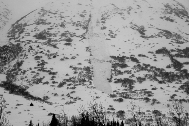
The avalanche danger remains HIGH at all elevations due to strong winds, rain and snowfall in Turnagain Pass,  Portage, Placer and Girdwood where natural avalanches 2-5′ thick are likely today.  Travel is not recommended in avalanche terrain where natural avalanches are likely occurring and human triggered avalanches are very likely.  Steer clear of gullies and the bottom of large and steep slopes in the event an avalanche releases above you.

Hiking in Portage Valley:  Travel along, and past, the designated Byron Glacier trail is not recommended due to exposure to avalanche terrain. Natural avalanches are possible today that could send debris to valley floors.

Summit Lake:  Travel in avalanche terrain is not recommended.  Read the  Saturday Summit Summary  HERE  including an avalanche triggered yesterday at Manitoba, HERE.

Special Announcements

A reminder that Skookum Valley is closed to motorized use as of yesterday,  Saturday,  April 1st. This is an annual closure as per the Chugach National Forest Plan document.  All other motorized areas remain open – see area status on the bottom of this page for more information.

Mon, April 3rd, 2017
Alpine
Above 2,500'
4 - High
Avalanche risk
Treeline
1,000'-2,500'
4 - High
Avalanche risk
Below Treeline
Below 1,000'
4 - High
Avalanche risk
0 - No Rating
1 - Low
2 - Moderate
3 - Considerable
4 - High
5 - Extreme
Avalanche risk Avalanche risk Avalanche risk Avalanche risk Avalanche risk
Travel Advice Generally safe avalanche conditions. Watch for unstable snow on isolated terrain features. Heightened avalanche conditions on specific terrain features. Evaluate snow and terrain carefully; identify features of concern. Dangerous avalanche conditions. Careful snowpack evaluation, cautious route-finding, and conservative decision-making essential. Very dangerous avalanche conditions. Travel in avalanche terrain not recommended. Extraordinarily dangerous avalanche conditions. Avoid all avalanche terrain.
Likelihood of Avalanches Natural and human-triggered avalanches unlikely. Natural avalanches unlikely; human-triggered avalanches possible. Natural avalanches possible; human-triggered avalanches likely. Natural avalanches likely; human-triggered avalanches very likely. Natural and human-triggered avalanches certain.
Avalanche Size and Distribution Small avalanches in isolated areas or extreme terrain. Small avalanches in specific areas; or large avalanches in isolated areas. Small avalanches in many areas; or large avalanches in specific areas; or very large avalanches in isolated areas. Large avalanches in many areas; or very large avalanches in specific areas. Very large avalanches in many areas.
Avalanche Problem 1
  • Storm Slabs
    Storm Slabs
Storm Slabs
Storm Slab avalanches are the release of a cohesive layer (a slab) of new snow that breaks within new snow or on the old snow surface. Storm-slabs typically last between a few hours and few days (following snowfall). Storm-slabs that form over a persistent weak layer (surface hoar, depth hoar, or near-surface facets) may be termed Persistent Slabs or may develop into Persistent Slabs.
More info at Avalanche.org

Today marks one week of elevated avalanche danger due to continuous stormy weather following a cold and dry March. A fast moving warm front will impact Southcentral, Alaska this morning, causing Easterly ridgetop winds to build into the 40’s (mph) with gusts in the 60’s (mph). Up to 6” of snow is forecasted to fall above 2000’; this is .45” of rain at lower elevations. Natural wind slab avalanches up to 1-2’ thick are likely today in the alpine due to blowing snow overloading steep slopes.This is on top of 2-4′ of snow that has incrementally fallen across our region over the last week. These storm related wind slabs have the potential to step down to an older layer in the snowpack, and run further than expected. (More on this below.) Avoiding all avalanche terrain, slopes steeper than 30 degrees, is the only way to manage this problem today. This includes giving run out zone plenty of space, and avoiding trails like Johnson Pass and Lynx Creek, where an avalanche could cross the trail. 

One of the many debris piles along the East face of Seattle Ridge over the last few days. This is a good example of how far things have been running in Turnagain, and reminder that today’s strong winds could be creating bigger slabs – increasing their run out distance. 

Avalanche Problem 2
  • Wet Loose
    Wet Loose
Wet Loose
Wet Loose avalanches are the release of wet unconsolidated snow or slush. These avalanches typically occur within layers of wet snow near the surface of the snowpack, but they may quickly gouge into lower snowpack layers. Like Loose Dry Avalanches, they start at a point and entrain snow as they move downhill, forming a fan-shaped avalanche. Other names for loose-wet avalanches include point-release avalanches or sluffs. Loose Wet avalanches can trigger slab avalanches that break into deeper snow layers.
More info at Avalanche.org

On Saturday rain falling on dry snow caused a cycle of wet slab avalanches below 1500’. Over the last two days an additional 6-12” of snow fell across our region insulating a layer of wet snow. Today another cycle of rain, up to a half an inch of water is forecasted below 2000’. This is a perfect recipe (rain falling on dry snow) to intiate another round of natural wet avalanche activity. To compound this, an avalanche in the alpine has the potential to run into the lower elevation band and intiate a wet slab avalanches – increasing the overall volume.  Again it will be important to avoid steep terrain and maintain a conservative distance from all runout zones. 

A wet slab that occurred between 1 and 2pm on Eddies on Saturday, 4/1/17. It was roughly 1-2′ thick and 300′ wide. The crown is near ~1500′ and was triggered by rain on the new snow from this week. However, if you look closely, it almost seems like it could have broken in an old weak layer that was not near the top of the pack. Photo by Wendy Wagner. 


Snowpit at 1500′ yesterday on Sunburst shows about 3″ of wet saturated snow perserved below yesterday’s new snow. 


Additional Concern
  • Persistent Slabs
    Persistent Slabs
Persistent Slabs
Persistent Slab avalanches are the release of a cohesive layer of snow (a slab) in the middle to upper snowpack, when the bond to an underlying persistent weak layer breaks. Persistent layers include: surface hoar, depth hoar, near-surface facets, or faceted snow. Persistent weak layers can continue to produce avalanches for days, weeks or even months, making them especially dangerous and tricky. As additional snow and wind events build a thicker slab on top of the persistent weak layer, this avalanche problem may develop into a Deep Persistent Slab.
More info at Avalanche.org

Several old layers of weak snow (near surface facets and surface hoar) sit buried in the snowpack. Avalanches releasing in the storm snow have the potential to ‘step down’ into them. Snowpack tests are still showing propagation potential in these layers and today’s strong winds and precipitation are likely to tip in the balanche in the upper elevations. An avalanche occuring in one of these older layers could be as deep as 3-5′, and run the entire length of slide path. 


A persistent slab avalanche triggered by a skier on Manitoba yesterday in Summit Lake. Luckily no one was cuaght or injured. Photo by Matteo Calcamuggi


A snowpit at Sunburst yesteday shows several weak layers (buried surface hoar and the March facets) that are sitting under this week’s snow. Snow totals in the alpine are estimated to be closer to 3-4′ where the snow has remained dry.


Weather
Mon, April 3rd, 2017

Yesterday rain/snow line moved from 200′ to 700′ late afternoon with daily warming. Scattered showers dropped an additional .4 € of H20 fell, 4 € of snow, along Turnagain Pass. Daytime temperatures reached a high of 41F mid day at Center ridge weather station. Skies were obscured and ridge top winds averaged around 20mph from the East. Overnight temps cooled to freezing, causing light rain to become snow again at sea level.

Today a warm front extending from a low pressure system in the Gulf of Alaska is quickly approaching South-central Alaska. Easterly ridge top wind are expected to build this morning from 20mph to 40mph by early afternoon, gusts could reach the 60mph’s. Warming temperatures will cause rain at lower elevations today and rain/snow line may reach 2000′ my mid day. Rain and snow showers are expected to pick up intensity by late afternoon, and a total of .45 € of water is expected by 6pm.  

Tonight precipitation should intensify, with an additional 1 € of H20 forecasted. Warm temperatures will likely keep precip as rain below 1000′ overnight. Strong Easterly winds are expected to last through tomorrow morning. Expect a similar pattern of low pressure systems to continue to impact our region through the week.  

PRECIPITATION 24-hour data (6am – 6am)

  Temp Avg (F) Snow (in) Water (in) Snow Depth (in)
Center Ridge (1880′) 34   3   0.4   75  
Summit Lake (1400′) 33   0   0   29  
Alyeska Mid (1700′) 31   2   0.28   75  

RIDGETOP 24-hour data (6am – 6am)

  Temp Avg (F) Wind Dir Wind Avg (mph) Wind Gust (mph)
Sunburst (3812′) 21 ENE   18   47  
Seattle Ridge (2400′) 26   rimed    rimed   rimed    
Observations
Recent Observations for Turnagain Pass
Date Region Location
04/16/24 Turnagain Observation: Cornbiscuit
04/15/24 Turnagain Observation: Taylor Pass
04/15/24 Turnagain Observation: Seward Highway – Tern Lake to Portage
04/14/24 Turnagain Observation: Sunburst
04/14/24 Turnagain Observation: Turnagain Pass Snomo
04/13/24 Turnagain Observation: Spokane Creek
04/11/24 Turnagain Observation: Tincan
04/10/24 Turnagain Avalanche: Seattle Ridge
04/10/24 Turnagain Observation: Cornbiscuit South Face
04/10/24 Turnagain Avalanche: Tincan
Riding Areas

The riding areas page has moved. Please click here & update your bookmarks.


Subscribe to Turnagain Pass
Avalanche Forecast by Email

This is a general backcountry avalanche advisory issued for Turnagain Arm with Turnagain Pass as the core advisory area. This advisory does not apply to highways, railroads or operating ski areas.