Turnagain Pass Avalanche Forecast
|
![]() ![]() |
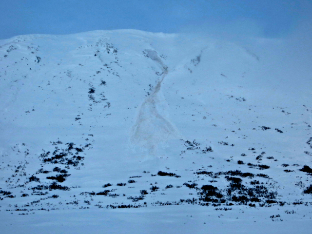
There is a CONSIDERABLE avalanche danger in the Turnagain Pass region at elevations above 1,000′. It is expected that triggering a slab avalanche 2-3’+ feet thick will be likely on slopes steeper than 30 degrees. This is due to weak snow sitting under 2-3′ of new snow. Cornice falls are likely as well which could trigger a large and dangerous avalanche below. Lastly, glide avalanches are still releasing with debris running into heavily used areas.
*These are dangerous avalanche conditions. Careful snowpack evaluation and conservative terrain selection is necessary for a safe day in the backcountry. Safer areas to recreate are on gentle slopes and/or in the flats.
**Dangerous avalanche conditions exist in the Summit Lake area as well. Please see today’s Summit Lake Summary for more information.
Today could be one of those days where someone could easily be caught in an avalanche: It will be our first chance for a break in cloud cover after a 4 day storm and it’s Saturday. The big concern centers around 2-3′ of new snow, which fell between Tuesday and Friday, that sits on a layer of weak older snow. This weak old snow was last weekend’s surface, which became loose and faceted along with a layer of surface hoar on top. Not only that, at the mid-elevations, between 2,000 and 3,000′, a crust exists below the weak snow (see photo below). What this all boils down to is that the new snow may not stabilize very quickly after this storm and people could trigger large and dangerous avalanches through the weekend. Things to keep in mind with this type of snowpack:
1) This unstable ‘set-up’ is one we have not seen this year
2) Triggering an avalanche remotely, from the side, top or below a slope is possible
3) The snowpack between 2,000′ and 3,000′ (where the weak snow/crust combination exists under the new snow) could be more unstable that the higher elevations. Crusts can inhibit stability and contribute to the possibility for remote triggers.
4) With little ground truth information at this point, very cautions terrain selection is required.
5) Sticking to slopes less than 30 degrees – with nothing steeper above you – to give the snowpack time to adjust is a great way to have a safe weekend in the backcountry.
The photo below shows the new snow at 2,000′. At this elevation the snow was very warm and dense; the rain snow line was just below this and lighter and deeper snow existed just above this.
The glide avalanche cycle continues…. Another glide crack released into a full-blown avalanche sometime late on Thursday or early Friday morning. These cracks are clearly still active and avalanching. Again, this is not the type of avalanche that can be triggered, but instead release spontaneously on their own. Just one more reason to avoid being under steep slopes today.
Photo: Glide avalanche on the Southeast face of Seattle Ridge, between the motorized lot and the motorized up-track.
With the warm and sticky nature of the new snow, cornices are likely to have grown even larger (they are already behemoths…) and be on the verge of collapse. These are not only hazards in themselves, but are also likely to trigger large avalanches below.
Yesterday we saw the tail end of the storm cycle move out with light snowfall adding roughly 1-3″ of new snow. 1″ fell at the Center Ridge SNOTEL at 1,900′ while 3″ fell in Girdwood Valley at the Alyeska Mid station. Winds died down as well with averages ~15mph from a generally East direction. Temperatures were warm (low 30’s at 1,000′) with a rain/snow line fluctuating between 1,000′ and 1,200′.
This morning we are seeing a quick pulse of moisture, increasing cloud cover and increasing Easterly winds move though. This should exit the region by mid-day and skies may break up if we are lucky. We may pick up another 1-3″ of snow with a rain/snow line ~500′ this morning. Winds are expected to be in the 15-25mph range from the East on the ridgetops. Temperatures look to hover in the upper 20’s at 1,000′ and near 20F at 4,000′.
For Sunday, another band of wind and snow looks to move in. We should see some breaks in this stormy pattern this week hover, so stay tuned.
Temp Avg (F) | Snow (in) | Water (in) | Snow Depth (in) | |
Center Ridge (1880′) | 28 | 1 | 0.1 | 110 |
Summit Lake (1400′) | 27 | 1 | 0.1 | 32 |
Alyeska Mid (1700′) | 30 | 3 | 0.33 | 87 |
Temp Avg (F) | Wind Dir | Wind Avg (mph) | Wind Gust (mph) | |
Sunburst (3812′) | 21 | NE | 15 | 46 |
Seattle Ridge (2400′) | 25 | – | – | – |
Date | Region | Location | Observer |
---|---|---|---|
03/26/23 | Turnagain | Avalanche: Sunburst avalanche investigation | Schauer/ Cullen Forecaster |
03/26/23 | Turnagain | Observation: Magnum shoulder | Matthew Howard |
03/25/23 | Turnagain | Avalanche: Seattle Ridge backside – several human triggered large avalanches | CNFAIC Staff |
03/25/23 | Turnagain | Avalanche: Seattle Ridge, 3rd Bowl, Rider Triggered Avalanches | CNFAIC Staff |
03/25/23 | Turnagain | Avalanche: Pastoral | Tony Naciuk |
03/25/23 | Turnagain | Avalanche: Eddie’s | James Howery |
03/25/23 | Turnagain | Observation: Eddies lower slopes | Anna Frick Bridget Psarianos |
03/25/23 | Turnagain | Observation: Sunny Side | Peter Wadsworth |
03/24/23 | Turnagain | Avalanche: Sunburst/Magnum | Megan Guinn & John Sykes Forecaster |
03/23/23 | Turnagain | Avalanche: Magnum | Amanda Goss |
Status of riding areas across the Chugach NF is managed by the Glacier and Seward Ranger Districts, not avalanche center staff. Riding area information is posted as a public service to our users and updated based on snow depth and snow density to prevent resource damage at trailhead locations. Riding area questions contact: mailroom_r10_chugach@fs.fed.us
Area | Status | Weather & Riding Conditions |
---|---|---|
Glacier District |
Subscribe to Turnagain Pass
Avalanche Forecast by Email
This is a general backcountry avalanche advisory issued for Turnagain Arm with Turnagain Pass as the core advisory area. This advisory does not apply to highways, railroads or operating ski areas.