Turnagain Pass Avalanche Forecast RSS

Archives
ARCHIVED FORECAST - All forecasts expire after 24 hours from the posting date/time.
Issued
Sun, January 17th, 2016 - 7:00AM
Expires
Mon, January 18th, 2016 - 7:00AM
Forecaster
Heather Thamm
Avalanche risk The Bottom Line

Today a MODERATE avalanche danger exists both in the Alpine and at Treeline. Above 2500′ triggering an isolated wind slab (1-2′ thick) could be possible on steep leeward terrain features. Below 2500′ in the Treeline zone, Glide cracks can release naturally and without warning. These problems can be avoided by carefully managing the terrain, assessing the snow, and avoiding zones with known glide cracks.

Should storm totals exceed the forecasted 3-5 € of snow today the danger could rise to CONSIDERABLE. Monitor changing conditions and alter your plans  accordingly.  

A LOW avalanche danger exists below 1000′ where triggering an avalanche is unlikely.  

*In Summit Lake, where a poor snow structure exists, the avalanche problem warrants extra caution. See yesterday’s observation  fron Fresno Ridge and visit our weekly Summit Summary for recent snowpack observations.  

Special Announcements

Our condolences go out to the family and friends of a snowboarder buried and killed in an avalanche yesterday at Hatcher Pass. We also want to extend a heartfelt €˜Thank You’ to the many people who participated in the prompt rescue efforts. Visit the Hatcher Pass Avalanche Center for more information about avalanche details and click HERE for the ADN article.  

Thanks to our sponsors!
Sun, January 17th, 2016
Alpine
Above 2,500'
Moderate (2)
Avalanche risk
Treeline
1,000'-2,500'
Moderate (2)
Avalanche risk
Below Treeline
Below 1,000'
Low (1)
Avalanche risk
Alpine
Above 2,500'
Avalanche risk
Moderate (2)
Treeline
1,000'-2,500'
Avalanche risk
Moderate (2)
Below Treeline
Below 1,000'
Avalanche risk
Low (1)
Danger Scale:
No Rating (0)
Low (1)
Moderate (2)
Considerable (3)
High (4)
Extreme (5)
Avalanche Problem 1
  • Storm Slabs
    Storm Slabs
Storm Slabs
Storm Slab avalanches are the release of a cohesive layer (a slab) of new snow that breaks within new snow or on the old snow surface. Storm-slabs typically last between a few hours and few days (following snowfall). Storm-slabs that form over a persistent weak layer (surface hoar, depth hoar, or near-surface facets) may be termed Persistent Slabs or may develop into Persistent Slabs.
More info at Avalanche.org

WIND SLABS: Three inches of new snow was recorded overnight and another 3-5” is expected today. Yesterday Easterly Ridgetop winds were sustained in 30’s mph and today moderate Easterly winds will continue into early afternoon. Remember wind has a unique ability to deposit snow 10 times faster than falling snow alone, thus isolated slabs could be as thick as 1-2’ on leeward aspects or cross-loaded features. The interface where this new snow is accumulating may harbor a poor interface (weak snow grains sitting a smooth bed surface.) This combination of wind, new snow and bed surface has the potential to create reactive wind slabs that could be triggered by a person or machine. Be on the look out for active wind loading, shooting cracks or ‘wumpfing’ sounds. Should you observe any of these obvious signs today keep your slope angles below 35°.

STORM SLABS: In places protected from the wind small storm slabs have the potential to become touchy. Temperatures have warmed slightly and this new snow is falling on low-density old snow sitting on a firm bed surface. Today’s forecasted snow totals will likely make for small low consequence slabs that will be isolated to steep terrain features. However if you see snow depths exceeding 6”, storm slabs could become large enough to catch a person in the wrong place. Thus today it will be important to monitor changing snow conditions and be aware consequences of any given terrain feature. 

Active windloading was observed in Summit Lake and the Sunburst Weather Station recored mulitple gusts in the 50’s mph yesterday.

Avalanche Problem 2
  • Glide Avalanches
    Glide Avalanches
Glide Avalanches
Glide Avalanches are the release of the entire snow cover as a result of gliding over the ground. Glide avalanches can be composed of wet, moist, or almost entirely dry snow. They typically occur in very specific paths, where the slope is steep enough and the ground surface is relatively smooth. They are often proceeded by full depth cracks (glide cracks), though the time between the appearance of a crack and an avalanche can vary between seconds and months. Glide avalanches are unlikely to be triggered by a person, are nearly impossible to forecast, and thus pose a hazard that is extremely difficult to manage.
More info at Avalanche.org

The glide crack problem continues to haunt Turnagain Pass. Yesterday a glide released on Seattle Ridge just minutes before we arrived. We didn’t talk to anyone who witnessed it in motion, but did hear some funny stories about being surprised by its sudden appearance.

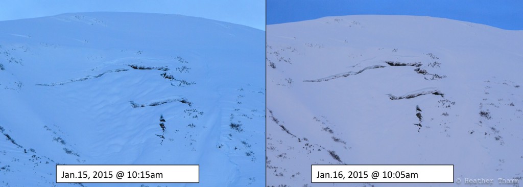
Glide cracks can form and release in seconds or days later or sometimes a glide crack won’t release at all. A good example of this can be seen in the photo diagrams below documenting two glide cracks on Seattle Ridge over a 24-hour period. The glide with a small visible crack released spontaneously where the larger glide crack on a similar slope had little change.

This unpredictable avalanche problem is best to avoid. Limit your exposure time in the run-out of a glide and do not test your luck on a slope below it. Today’s visibility is likely to be poor, which can make it challenging to see existing glides. In general these cracks have been observed all along the East face Seattle Ridge in the 1500’ to 2500’ elevation band. As of yesterday morning the snow machine uptrack did not harbor any cracks, but given their spontaneous nature it is not impossible for one to form. See yesterday’s Advisory and visit our Observations Page for more pictures of existing glides in the area. 

The left hand glide released around ~10am on January 16th and the glide on the right released sometime bween January14th – 15th. East face of Seattle Ridge.


Glide release observed within a 24 hour period on Seattle Ridge.


Observed over the same amount of time as glides above, this glide had little to no movement.


Weather
Sun, January 17th, 2016

Yesterday 3 € of new snow was recorded at the Turnagain Pass SNOTEL. Easterly tidgetop winds averaged in the 30’s mph with gusts in the 50’s mph. Temperatures increased overnight to 33F along the road at Turnagain Pass (1000′.)

Today rain and snow is expected below 1000′ and accumulation of 3-5 € of snow is expected at higher elevations. Easterly Ridgetop winds are starting to decrease, but could remain 15-30mph along ridgetops through the afternoon.  

Tomorrow, Martin Luther King Day, a chance of rain and snow is expected with similar temperatures as today.  

PRECIPITATION 24-hour data (6am – 6am)

  Temp Avg (F) Snow (in) Water (in) Snow Depth (in)
Center Ridge (1880′) 30   3   0.3   84  
Summit Lake (1400′) 30   0   0   26  
Alyeska Mid (1700′)  30 3    0.31 63  

RIDGETOP 24-hour data (6am – 6am)

  Temp Avg (F) Wind Dir Wind Avg (mph) Wind Gust (mph)
Sunburst (3812′) 23    NE  24 60  
Seattle Ridge (2400′) 25   ~   ~   ~  
Observations
Recent Observations for Turnagain Pass
Date Region Location
05/22/23 Turnagain Avalanche: Tincan
05/12/23 Turnagain Avalanche: Tincan, Sunburst, Magnum, Cornbiscuit
05/07/23 Turnagain Observation: Tincan – Bear Tracks
05/05/23 Turnagain Observation: Seattle Ridge
05/02/23 Turnagain Observation: Cornbiscuit
05/02/23 Turnagain Observation: Seward Hwy Turnagain Pass
04/30/23 Turnagain Observation: Magnum
04/29/23 Turnagain Observation: Tincan
04/28/23 Turnagain Avalanche: Taylor Pass/Pastoral
04/28/23 Turnagain Avalanche: Tincan
Riding Areas
Updated Thu, June 01st, 2023

Status of riding areas across the Chugach NF is managed by the Glacier and Seward Ranger Districts, not avalanche center staff. Riding area information is posted as a public service to our users and updated based on snow depth and snow density to prevent resource damage at trailhead locations. Riding area questions contact: mailroom_r10_chugach@fs.fed.us

Area Status Weather & Riding Conditions
Glacier District
Johnson Pass
Closed
Closed May 15.
Placer River
Closed
Closed May 15.
Skookum Drainage
Closed
Will close to motorized use on April 1, 2023 per the National Forest Plan.
Turnagain Pass
Closed
Will close on June 1.
Twentymile
Closed
Scheduled closure May 1.
Seward District
Carter Lake
Closed
Scheduled closure May 1.
Lost Lake Trail
Closed
Scheduled closure May 1.
Primrose Trail
Closed
Scheduled closure May 1.
Resurrection Pass Trail
Closed
Closed to motorized use for the 2022/23 winter season per Forest Plan. Open next season.
Snug Harbor
Closed
Extended opening until May 15.
South Fork Snow River Corridor
Closed
Scheduled closure May 1.
Summit Lake
Closed
Scheduled closure May 1.

Subscribe to Turnagain Pass
Avalanche Forecast by Email

This is a general backcountry avalanche advisory issued for Turnagain Arm with Turnagain Pass as the core advisory area. This advisory does not apply to highways, railroads or operating ski areas.