Turnagain Pass Avalanche Forecast RSS

Archives
ARCHIVED FORECAST - All forecasts expire after 24 hours from the posting date/time.
Issued
Tue, December 29th, 2015 - 7:00AM
Expires
Wed, December 30th, 2015 - 7:00AM
Forecaster
Graham Predeger
Avalanche risk The Bottom Line

A  CONSIDERABLE  avalanche danger exists in the backcountry today above 1,000′.   Strong winds and new snow have added substantial weight to a tenuous snowpack with known weak layers where potential exists to trigger a wind slab 3+ feet deep on leeward slopes (West and South).   Cornices are also growing quite large and are a legitimate concern whether you find yourself above or below one of these behemoths.   Cautious route finding and conservative decision-making will be essential today as you move through the backcountry.

Below treeline the danger is  MODERATE  specifically in channeled terrain where an avalanche releasing high above you can run into the low elevations.

Special Announcements

FCNFAIC is now accepting applications for TWO NEW scholarships! Both scholarships are for avalanche education up to $500. One will be awarded to a snowmachiner and the other to a skier or non-motorized user.

 Please include in your application: name, mailing address, your financial need and how you plan to spread avalanche awareness to your community post-award.   Applications due by 10PM on January 6th.   Please send  your applications to  chugachavyfriends@gmail.com

The Friends-CNFAIC board  looks forward to hearing from you!

Thanks to our sponsors!
Tue, December 29th, 2015
Alpine
Above 2,500'
Considerable (3)
Avalanche risk
Treeline
1,000'-2,500'
Considerable (3)
Avalanche risk
Below Treeline
Below 1,000'
Moderate (2)
Avalanche risk
Alpine
Above 2,500'
Avalanche risk
Considerable (3)
Treeline
1,000'-2,500'
Avalanche risk
Considerable (3)
Below Treeline
Below 1,000'
Avalanche risk
Moderate (2)
Danger Scale:
No Rating (0)
Low (1)
Moderate (2)
Considerable (3)
High (4)
Extreme (5)
Avalanche Problem 1
  • Wind Slabs
    Wind Slabs
Wind Slabs
Wind Slab avalanches are the release of a cohesive layer of snow (a slab) formed by the wind. Wind typically transports snow from the upwind sides of terrain features and deposits snow on the downwind side. Wind slabs are often smooth and rounded and sometimes sound hollow, and can range from soft to hard. Wind slabs that form over a persistent weak layer (surface hoar, depth hoar, or near-surface facets) may be termed Persistent Slabs or may develop into Persistent Slabs.
More info at Avalanche.org

A 112mph gust on Sunburst yesterday and a flipped over tractor trailer on the Portage Valley Highway are both indicative of a wind slab issue today.  Winds were primarily out of the ENE yesterday and overnight meaning slopes with a south and westerly tilt will be most suspect for triggering a wind slab.  Strong winds such as this have a tendency to build wind slabs mid slope (further from the ridge crest).  For skiers this means that mid-run you may find yourself on the slab; and for snowmachiners who generally attack a slope from the base, recognize that wind slab may be mid-hill climb, well below the ridge crest. 

Watch out for any obvious red flags today such as whumphing, shooting crack or recent avalanches.  Whumphing was present for several groups yesterday and is indicitive of a weak layer collapse.  Sometimes this is harder to identify from your snowmachine but it’ll be worth the time today to slow down and keep a keen eye/ ear.  As wind has a tendency to distribute snow unevenly across any given slope, a skier or snowmachiner is more likely to influence the weak layer in these areas where the slab is thinner.  Shallow spots near rock outcrops or alder will be the more likely trigger points where your skis or snowmachine track is physiclly that much closer to the weak layer.  

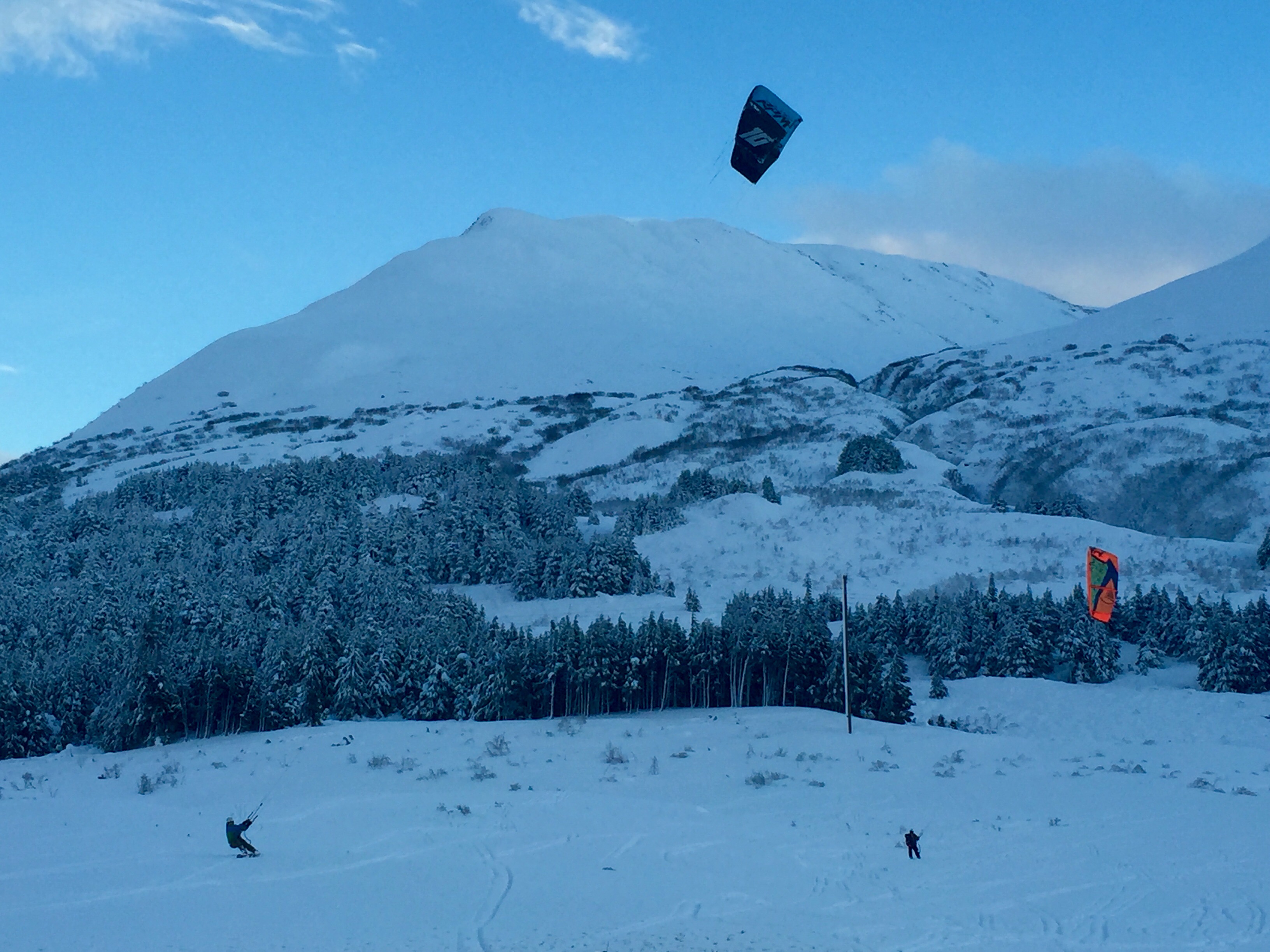
Folks were generally keeping terrain choices mellow yesterday, including these two kite skiers capitalizing on the sustained winds yesterday afternoon in the shadow of Sunburst.  

Avalanche Problem 2
  • Cornice
    Cornice
Cornice
Cornice Fall is the release of an overhanging mass of snow that forms as the wind moves snow over a sharp terrain feature, such as a ridge, and deposits snow on the downwind (leeward) side. Cornices range in size from small wind drifts of soft snow to large overhangs of hard snow that are 30 feet (10 meters) or taller. They can break off the terrain suddenly and pull back onto the ridge top and catch people by surprise even on the flat ground above the slope. Even small cornices can have enough mass to be destructive and deadly. Cornice Fall can entrain loose surface snow or trigger slab avalanches.
More info at Avalanche.org

These warm, windy storms have a tendency to grow cornices rapidly here in the Chugach and Kenai mountains.  These ‘backcountry bombs’ deserve an extra wide berth today and throughout this “New Year storm cycle”.  A cornice breaking either naturally or from human traffic has the potential to trigger a large avalanche as it falls on the slope below.  Limit time spent below a cornice and if travelling along a ridge, stay back waaaaaay further than you think necessary to give yourself that added margin of safety.

Additional Concern
  • Persistent Slabs
    Persistent Slabs
Persistent Slabs
Persistent Slab avalanches are the release of a cohesive layer of snow (a slab) in the middle to upper snowpack, when the bond to an underlying persistent weak layer breaks. Persistent layers include: surface hoar, depth hoar, near-surface facets, or faceted snow. Persistent weak layers can continue to produce avalanches for days, weeks or even months, making them especially dangerous and tricky. As additional snow and wind events build a thicker slab on top of the persistent weak layer, this avalanche problem may develop into a Deep Persistent Slab.
More info at Avalanche.org

Given the current structure of our snowpack, we have reason for concern as these potent late-December storms are falling on top of a couple of older known persistent weak layers.  With more weight in the form of snow and wind yesterday and today, these weak layers can edge closer to their point of failure, laying in wait for a trigger.  Yesterday, Alaska Railroad avalanche reduction crews had several avalanche results using explosives to trigger these weak layers.  They saw debris running to the valley floor in channelized terrain.

Weather
Tue, December 29th, 2015

Heavy snow and strong northeasterly winds on Turnagain pass subsided around 3pm yesterday after a 112mph gust on Sunburst and 4-6 € of heavy, wet snow fell at 1,000′.   Skies broke apart allowing a brief glimpse into upper elevation start zones.   Temperatures hovered right around 32F at 1,000′ and 35F at sea level.   Rain and strong winds persisted throughout the day in the Girdwood and Portage valleys.  

Today we can expect temperatures in the mid-30’s and ridgetop winds from the SE in the 20-40mph range.   Cloud cover will be on the increase throughout the day and precipitation in the form of a rain/ snow mix at 1,000′ will be light during daylight hours and increasing tonight.

Late tonight and into tomorrow we’ll be feeling the full effect of another powerful and unseasonably warm and windy Gulf of Alaska storm.   The NWS has issued another high wind warning that goes into effect tomorrow morning.

PRECIPITATION 24-hour data (6am – 6am)

  Temp Avg (F) Snow (in) Water (in) Snow Depth (in)
Center Ridge (1880′)  31  4 .7   67  
Summit Lake (1400′)  34  1  .3 20  
Alyeska Mid (1700′)  31  4 .6   60  

RIDGETOP 24-hour data (6am – 6am)

  Temp Avg (F) Wind Dir Wind Avg (mph) Wind Gust (mph)
Sunburst (3812′)  24  E 28   112  
Seattle Ridge (2400′)  26 N/A   N/A   N/A  
Observations
Recent Observations for Turnagain Pass
Date Region Location
05/22/23 Turnagain Avalanche: Tincan
05/12/23 Turnagain Avalanche: Tincan, Sunburst, Magnum, Cornbiscuit
05/07/23 Turnagain Observation: Tincan – Bear Tracks
05/05/23 Turnagain Observation: Seattle Ridge
05/02/23 Turnagain Observation: Cornbiscuit
05/02/23 Turnagain Observation: Seward Hwy Turnagain Pass
04/30/23 Turnagain Observation: Magnum
04/29/23 Turnagain Observation: Tincan
04/28/23 Turnagain Avalanche: Taylor Pass/Pastoral
04/28/23 Turnagain Avalanche: Tincan
Riding Areas
Updated Sat, September 23rd, 2023

Status of riding areas across the Chugach NF is managed by the Glacier and Seward Ranger Districts, not avalanche center staff. Riding area information is posted as a public service to our users and updated based on snow depth and snow density to prevent resource damage at trailhead locations. Riding area questions contact: mailroom_r10_chugach@fs.fed.us

Area Status Weather & Riding Conditions
Glacier District
Johnson Pass
Closed
Scheduled opening per Chugach National Forest plan December 1. Subject to adequate snow cover.
Placer River
Closed
Scheduled opening per Chugach National Forest plan December 1. Subject to adequate snow cover.
Skookum Drainage
Closed
Scheduled opening per Chugach National Forest plan December 1. Subject to adequate snow cover.
Turnagain Pass
Closed
Scheduled opening on the Wednesday before Thanksgiving per Chugach National Forest plan. Subject to adequate snow cover.
Twentymile
Closed
Scheduled opening per Chugach National Forest plan December 1. Subject to adequate snow cover.
Seward District
Carter Lake
Closed
Scheduled opening per Chugach National Forest plan December 1. Subject to adequate snow cover.
Lost Lake Trail
Closed
Scheduled opening per Chugach National Forest plan December 1. Subject to adequate snow cover.
Primrose Trail
Closed
Scheduled opening per Chugach National Forest plan December 1. Subject to adequate snow cover.
Resurrection Pass Trail
Closed
Scheduled opening per Chugach National Forest plan December 1. Subject to adequate snow cover.
Snug Harbor
Closed
Scheduled opening per Chugach National Forest plan December 1. Subject to adequate snow cover.
South Fork Snow River Corridor
Closed
Scheduled opening per Chugach National Forest plan December 1. Subject to adequate snow cover.
Summit Lake
Closed
Scheduled opening per Chugach National Forest plan December 1. Subject to adequate snow cover.

Subscribe to Turnagain Pass
Avalanche Forecast by Email

This is a general backcountry avalanche advisory issued for Turnagain Arm with Turnagain Pass as the core advisory area. This advisory does not apply to highways, railroads or operating ski areas.