Turnagain Pass Avalanche Forecast RSS

Archives
ARCHIVED FORECAST - All forecasts expire after 24 hours from the posting date/time.
Issued
Wed, March 4th, 2015 - 7:00AM
Expires
Thu, March 5th, 2015 - 7:00AM
Forecaster
Graham Predeger
Avalanche risk The Bottom Line

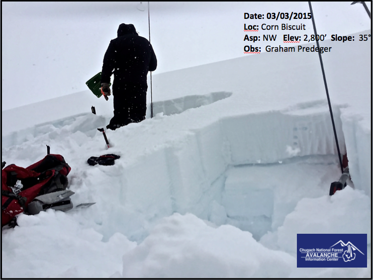
There is a MODERATE avalanche danger above 2,500′ where weak, faceted snow is still being found 1-2 feet below the surface and triggering a slab in steep terrain (>35 degrees) will be possible.   Careful terrain and snowpack assessment are warranted above treeline today.

The danger is  LOW  at Treeline and below where triggering an avalanche is unlikely.

Special Announcements

Our NEW OBSERVATION PAGE is up and running!  Please check out the new format and consider submitting a snowpack or avalanche observation on your next day in the mountains.  We are always looking for more info and photos to help paint a better picture of avalanche hazards across south central Alaska!

Thanks to our sponsors!
Wed, March 4th, 2015
Alpine
Above 2,500'
Moderate (2)
Avalanche risk
Treeline
1,000'-2,500'
Low (1)
Avalanche risk
Below Treeline
Below 1,000'
No Rating (0)
Avalanche risk
Alpine
Above 2,500'
Avalanche risk
Moderate (2)
Treeline
1,000'-2,500'
Avalanche risk
Low (1)
Below Treeline
Below 1,000'
Avalanche risk
No Rating (0)
Danger Scale:
No Rating (0)
Low (1)
Moderate (2)
Considerable (3)
High (4)
Extreme (5)
Avalanche Problem 1
  • Persistent Slabs
    Persistent Slabs
Persistent Slabs
Persistent Slab avalanches are the release of a cohesive layer of snow (a slab) in the middle to upper snowpack, when the bond to an underlying persistent weak layer breaks. Persistent layers include: surface hoar, depth hoar, near-surface facets, or faceted snow. Persistent weak layers can continue to produce avalanches for days, weeks or even months, making them especially dangerous and tricky. As additional snow and wind events build a thicker slab on top of the persistent weak layer, this avalanche problem may develop into a Deep Persistent Slab.
More info at Avalanche.org

Snowpit information again yesterday points toward a layer of weak, faceted snow that is still showing signs of mischievous behavior above about 2,500’.  This is roughly where the stout and supportable melt/ freeze crust begins to thin out enough for a skiers weight to physically upset these buried facets. 

We found a high degree of variability across any given slope yesterday with unstable snow (moderate strength, high propagation potential) in one snowpit and generally stable snow just 15 feet away.  This points toward a slab that is not widely connected across slopes.  Of course snowpit data is just one small piece of the puzzle and it’s possible that someone could get away with skiing bigger, steeper lines without incident today but it is worth keeping in mind the nature of a persistent weak layer.  It often takes weeks or even months for these to heal.  The general rule for a facet is that once buried, it is not to be trusted until it’s in the River’. 

It is still important to treat steep and complex terrain with suspicion today.  Practice safe travel protocol, assess terrain before committing and minimize your exposure accordingly.  Avoid trigger points (thin spots or steep roll overs) on terrain over 35 degrees and travel one at a time on suspect slopes using islands of safety as you go.

We were finding a high degree of variability across slopes, even in snowpits this close together.  More info on the NEW OBSERVATIONS PAGE!

Weather
Wed, March 4th, 2015

Yesterday saw winds diminishing and temperatures climbing throughout the day.   In the morning hours the rain snow line hovered around 600′ but by mid-afternoon that had climbed to roughly 1800′ with light rain/ snow under grey-bird skies.  

Today looks to be much of the same as we are under the influence of warm, moist southerly flow with light rain/ snow continuing at least thru the morning and tapering off this afternoon.   Rain/ snow line looks to be around 1,000′ where we may see an inch of snow accumulation throughout the day.   Ridge top winds are expected to be from the East in the 10-15mph range with temperatures in the high 20’s at 3,000′ and low to mid 30’s at 1,000′

Heading into the weekend, a series of weak lows will continue to move through our area promoting a similar rain/ snow mix in south central AK. Late in the weekend (Sunday) and into next week temperatures appear to cool off enough to support all snow.

PRECIPITATION 24-hour data (6am – 6am)

  Temp Avg (F) Snow (in) Water (in) Snow Depth (in)
Center Ridge (1880′) 33    1  .2  41
Summit Lake (1400′) 33 0   .02    7
Alyeska Mid (1700′) 33    1 .1    25.5

RIDGETOP 24-hour data (6am – 6am)

  Temp Avg (F) Wind Dir Wind Avg (mph) Wind Gust (mph)
Sunburst (3812′)  25  ENE  11 28  
Seattle Ridge (2400′) 27    n/a 17   35  
Observations
Recent Observations for Turnagain Pass
Date Region Location
05/22/23 Turnagain Avalanche: Tincan
05/12/23 Turnagain Avalanche: Tincan, Sunburst, Magnum, Cornbiscuit
05/07/23 Turnagain Observation: Tincan – Bear Tracks
05/05/23 Turnagain Observation: Seattle Ridge
05/02/23 Turnagain Observation: Cornbiscuit
05/02/23 Turnagain Observation: Seward Hwy Turnagain Pass
04/30/23 Turnagain Observation: Magnum
04/29/23 Turnagain Observation: Tincan
04/28/23 Turnagain Avalanche: Taylor Pass/Pastoral
04/28/23 Turnagain Avalanche: Tincan
Riding Areas
Updated Thu, June 01st, 2023

Status of riding areas across the Chugach NF is managed by the Glacier and Seward Ranger Districts, not avalanche center staff. Riding area information is posted as a public service to our users and updated based on snow depth and snow density to prevent resource damage at trailhead locations. Riding area questions contact: mailroom_r10_chugach@fs.fed.us

Area Status Weather & Riding Conditions
Glacier District
Johnson Pass
Closed
Closed May 15.
Placer River
Closed
Closed May 15.
Skookum Drainage
Closed
Will close to motorized use on April 1, 2023 per the National Forest Plan.
Turnagain Pass
Closed
Will close on June 1.
Twentymile
Closed
Scheduled closure May 1.
Seward District
Carter Lake
Closed
Scheduled closure May 1.
Lost Lake Trail
Closed
Scheduled closure May 1.
Primrose Trail
Closed
Scheduled closure May 1.
Resurrection Pass Trail
Closed
Closed to motorized use for the 2022/23 winter season per Forest Plan. Open next season.
Snug Harbor
Closed
Extended opening until May 15.
South Fork Snow River Corridor
Closed
Scheduled closure May 1.
Summit Lake
Closed
Scheduled closure May 1.

Subscribe to Turnagain Pass
Avalanche Forecast by Email

This is a general backcountry avalanche advisory issued for Turnagain Arm with Turnagain Pass as the core advisory area. This advisory does not apply to highways, railroads or operating ski areas.