Turnagain Pass Avalanche Forecast
|
![]() ![]() |
The avalanche danger remains CONSIDERABLE at elevations above 2,500′ on all aspects. At these above treeline elevations, human triggered slab avalanches 2-4′ in depth continue to be likely on slopes over 35 degrees. At the treeline elevations there is a MODERATE danger where it is possible to trigger a slab avalanche in the 2,000′ – 2,500′ zone. Below 2,000′ triggering an avalanche will be unlikely.
If skies clear enough for travel above treeline today, we recommend to keep close tabs on your powder fever. We are approaching a period of lower probability of triggering an avalanche but continued high consequences. Choosing terrain wisely will be essential. This means avoiding slopes over 35 degrees, steep rollovers and thin snow cover areas below or adjacent to steeper slopes.
It was a relatively quiet day in the backcountry yesterday; one day after an eventful Thursday where two large human triggered avalanches occurred with one resulting in a full burial – details on those HERE and HERE. One reason for the quiet day was possibly the low visibility hampering travel too far from treeline and the other possibly, the one we hope, is that people are sticking to lower angle slopes due to the poor snowpack stability.
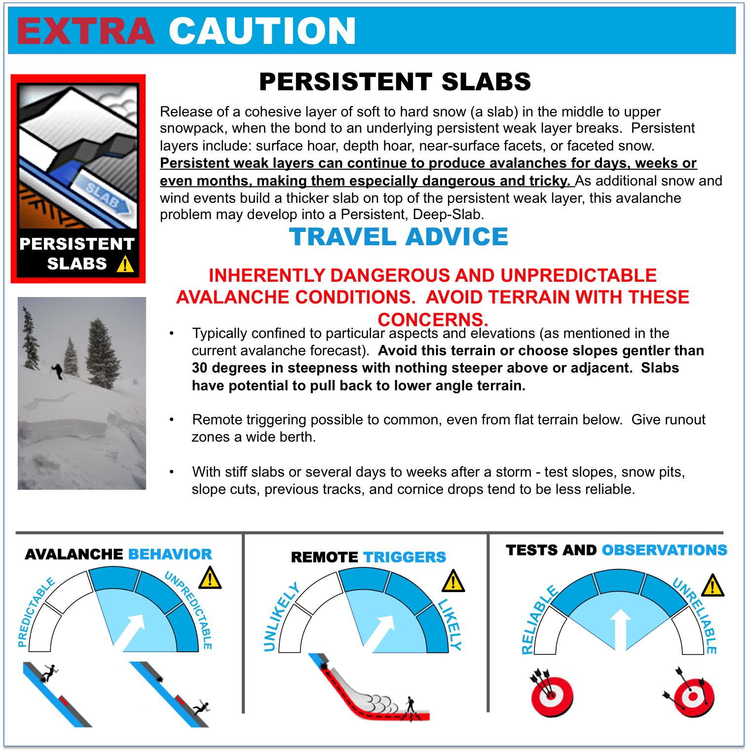
Today marks the fourth day since a 3 day storm brought 24-40+” to Turnagain Pass and surrounding zones. Buried under the storm snow is a widespread and intact layer of buried surface hoar that is responsible for the recent avalanche activity. We have been tracking this buried persistent weak layer and it is showing signs of becoming stronger (hence, harder to trigger an avalanche). HOWEVER, we have only been able to access very few areas. These are the same areas folks have been getting into – namely low angle slopes on the Tincan and Sunburst ridges. In fact, our staff deemed the risk too high to investigate the Sunburst avalanche yesterday becuase of the required exposure to steep slope angles. This leaves a lot of unknowns for when skies clear and travel is possible to further reaches of the forecast zone. All signs point to conservative decision making. What we do know is that the buried surface hoar exists to the ridgetops and is covered with a slab that ranges widely: from 4-5′ in the Girdwood Valley to 2-4′ in the Turnagain Pass zone and 1-2′ further south in the Summit Lake area.
For today, continued patience is recommended. Enjoying quality snow conditions can be had by sticking to low angle slopes, avoiding steep rollovers and staying away from the steeper terrain. Click this hyperlink for a definition of a “Persistent Slab” and the Travel Advice associated with it.
The winds kicked up into the 15-20mph range from the North and East yesterday. With plenty of loose snow available for transport, soft wind slabs and drifts formed on leeward aspects. This concern is trumped by the primary concern above, yet is worth noting for two reasons. One, it adds additional load to the slab resting on the buried surface hoar. And two, wind slabs may be found below 2,500′ where triggering a larger slab is less likely.
Yesterday brought intermittent snow showers and partly cloudy skies. Around 1″ snow accumulated with light to moderate winds from the East (details in the charts below). Temperatures were mild, yet cold enough for snow to ~500.
For today, we should see partly sunny skies and intermittent cloud cover as a series of low pressure systems spin to our South. Since we are above the action, ridgetop winds are expected to be light from the East and temperatures mild (mid 30’s F at 1,000′ and the low 20’s to 30F on the ridgetops).
The exciting news is for Sunday and into Monday where a good chance for snow region-wide is developing! Stay tuned, but as of now the models are pointing toward a low pressure system over the Kenai with just enough associated dynamics to push moist air over the Kenai and Chugach mountains and into Anchorage and other areas of mainland Southcentral. Temperatures will be cold enough for snow to sea level.
For the early part of this week, a break between storms is likely for Tuesday into Wednesday with another large low pressure moving in for Christmas Day.
Temp Avg (F) | Snow (in) | Water (in) | Snow Depth (in) | |
Center Ridge (1880′) | 32 | 1 | 0.1 | 28 |
Summit Lake (1400′) | 30 | 0 | 0 | 4 |
Alyeska Mid (1700′) | 31 | 0 | 0 | 18 |
Temp Avg (F) | Wind Dir | Wind Avg (mph) | Wind Gust (mph) | |
Sunburst (3812′) | 25 | E | 15 | 39 |
Seattle Ridge (2400′) | 26 | N/A | N/A | N/A |
Date | Region | Location | Observer |
---|---|---|---|
01/31/23 | Turnagain | Observation: Johnson Pass area | Megan Guinn / W Wagner Forecaster |
01/29/23 | Turnagain | Observation: Tincan Backdoor | AAS-Level 1 1/27-1/30 |
01/28/23 | Turnagain | Observation: Sunburst | Brooke Edwards |
01/28/23 | Turnagain | Avalanche: Seattle Ridge | W Wagner |
01/28/23 | Turnagain | Observation: Tincan Common | Tony Naciuk |
01/27/23 | Turnagain | Observation: Sunburst | John Sykes |
01/27/23 | Turnagain | Avalanche: Lynx Creek | Megan Guinn / W Wagner |
01/25/23 | Turnagain | Observation: Cornbiscuit | John Sykes Forecaster |
01/22/23 | Turnagain | Avalanche: Tincan | Schauer/ Guinn |
01/21/23 | Turnagain | Avalanche: Seattle Ridge | Elias Holt |
Status of riding areas across the Chugach NF is managed by the Glacier and Seward Ranger Districts, not avalanche center staff. Riding area information is posted as a public service to our users and updated based on snow depth and snow density to prevent resource damage at trailhead locations. Riding area questions contact: mailroom_r10_chugach@fs.fed.us
Area | Status | Weather & Riding Conditions |
---|---|---|
Glacier District |
Subscribe to Turnagain Pass
Avalanche Forecast by Email
This is a general backcountry avalanche advisory issued for Turnagain Arm with Turnagain Pass as the core advisory area. This advisory does not apply to highways, railroads or operating ski areas.