Turnagain Pass RSS

Archives
ARCHIVED - Forecasts expire after 24 hours.
Issued
Fri, December 14th, 2012 - 7:00AM
Expires
Sat, December 15th, 2012 - 7:00AM
Forecaster
Wendy Wagner
Avalanche risk The Bottom Line

BOTTOM LINE

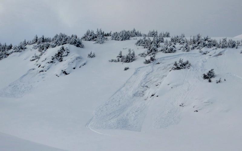
A CONSIDERABLE avalanche danger continues above treeline today. Weak faceted snow underneath the new snow from Saturday and Wednesday produced both natural and human triggered avalanche activity yesterday (see below). Today, the natural activity can be expected to diminish but human triggered avalanches are still likely. Most prone areas are slopes steeper than 35 degrees in areas with wind deposited snow or areas just out of the wind affected snow and sporting good riding conditions. Below treeline there is a MODERATE danger of triggering a slab on these steeper slopes.

Remember your good travel practices. Only exposing one person at a time, keeping a close eye on your partners and discussing potential avalanche areas/consequences will be prudent.

Fri, December 14th, 2012
Alpine
Above 2,500'
3 - Considerable
Avalanche risk
Treeline
1,000'-2,500'
2 - Moderate
Avalanche risk
Below Treeline
Below 1,000'
2 - Moderate
Avalanche risk
0 - No Rating
1 - Low
2 - Moderate
3 - Considerable
4 - High
5 - Extreme
Avalanche risk Avalanche risk Avalanche risk Avalanche risk Avalanche risk
Travel Advice Generally safe avalanche conditions. Watch for unstable snow on isolated terrain features. Heightened avalanche conditions on specific terrain features. Evaluate snow and terrain carefully; identify features of concern. Dangerous avalanche conditions. Careful snowpack evaluation, cautious route-finding, and conservative decision-making essential. Very dangerous avalanche conditions. Travel in avalanche terrain not recommended. Extraordinarily dangerous avalanche conditions. Avoid all avalanche terrain.
Likelihood of Avalanches Natural and human-triggered avalanches unlikely. Natural avalanches unlikely; human-triggered avalanches possible. Natural avalanches possible; human-triggered avalanches likely. Natural avalanches likely; human-triggered avalanches very likely. Natural and human-triggered avalanches certain.
Avalanche Size and Distribution Small avalanches in isolated areas or extreme terrain. Small avalanches in specific areas; or large avalanches in isolated areas. Small avalanches in many areas; or large avalanches in specific areas; or very large avalanches in isolated areas. Large avalanches in many areas; or very large avalanches in specific areas. Very large avalanches in many areas.
Avalanche Problem 1
  • Wind Slabs
    Wind Slabs
Wind Slabs
Wind Slab avalanches are the release of a cohesive layer of snow (a slab) formed by the wind. Wind typically transports snow from the upwind sides of terrain features and deposits snow on the downwind side. Wind slabs are often smooth and rounded and sometimes sound hollow, and can range from soft to hard. Wind slabs that form over a persistent weak layer (surface hoar, depth hoar, or near-surface facets) may be termed Persistent Slabs or may develop into Persistent Slabs.
More info at Avalanche.org

Widespread natural avalanche activity was seen on the east face of Seattle Ridge yesterday – releasing sometime in the morning hours. These slopes were loaded by moderate westerly winds, not associated with snowfall, that shifted from the predominant easterly flow Wednesday night through last night. This is the first significant avalanche activity seen on east aspects.

Today, a shift back to west winds, increasing to 30mph by this evening, may not be enough for fresh slabs to develop during the daylight hours, but any slabs from the past several days are still VERY suspect for human triggering as they are sitting on weak faceted snow. Especially concerning in areas that have not seen much traffic.

Avalanche Problem 2
  • Persistent Slabs
    Persistent Slabs
Persistent Slabs
Persistent Slab avalanches are the release of a cohesive layer of snow (a slab) in the middle to upper snowpack, when the bond to an underlying persistent weak layer breaks. Persistent layers include: surface hoar, depth hoar, near-surface facets, or faceted snow. Persistent weak layers can continue to produce avalanches for days, weeks or even months, making them especially dangerous and tricky. As additional snow and wind events build a thicker slab on top of the persistent weak layer, this avalanche problem may develop into a Deep Persistent Slab.
More info at Avalanche.org

If one remembers back a week ago to the end of our period of cold and clear weather then you’ll remember how weak the surface snow was then. So weak it would easily sluff down the slope without much effort. This was the result of extensive faceting under clear and cold conditions that created what we are now calling the November facets. We have now added ~16” of snow from two storms on top of these weak facets resulting in easy natural and human triggered avalanches. The tenuous nature of the weak layer reared its head yesterday with the significant natural activity on E Seattle Ridge mentioned above.

Yet, even areas out of the wind affected snow are concerning. Our party yesterday easily triggered a small slope, just out of the wind, that failed in the November facets and kept us off any larger steeper slopes. Collapsing is still prevalent, and other than recent avalanches is your best clue to unstable snow – this has been keeping many people off the steeper and more committing terrain. That said, the riding conditions are quite improved and good terrain management can make for a great day in the backcounty.

Weather
Fri, December 14th, 2012

The westerly winds that kept ridgetops chilly and avalanche activity present yesterday have shifted back to the east overnight where they have been light. Today they swing back to the west again and pick up to the 25-30mph range by this evening. Temperatures should remain in the teens today with mostly clear skies.

Saturday, very cold air moves in with a good push from a northwesterly flow and temperatures should drop significantly €“ back to the minus single and double digits. Our next shot of precip is several days away at best.


This is a general backcountry avalanche advisory issued for Turnagain Arm with Turnagain Pass as the core advisory area (this advisory does not apply to highways, railroads, or operating ski areas).  

Kevin will issue the next advisory Saturday morning, December 15th.

Observations
Recent Observations for Turnagain Pass
Date Region Location
04/23/24 Turnagain Observation: Turnagain Sunny Side
04/21/24 Turnagain Observation: Bertha Creek
04/20/24 Turnagain Avalanche: Spokane Creek
04/16/24 Turnagain Observation: Cornbiscuit
04/15/24 Turnagain Observation: Taylor Pass
04/15/24 Turnagain Observation: Seward Highway – Tern Lake to Portage
04/14/24 Turnagain Observation: Sunburst
04/14/24 Turnagain Observation: Turnagain Pass Snomo
04/13/24 Turnagain Observation: Spokane Creek
04/11/24 Turnagain Observation: Tincan
Riding Areas

The riding areas page has moved. Please click here & update your bookmarks.


Subscribe to Turnagain Pass
Avalanche Forecast by Email

This is a general backcountry avalanche advisory issued for Turnagain Arm with Turnagain Pass as the core advisory area. This advisory does not apply to highways, railroads or operating ski areas.