Turnagain Pass
|
|
Good morning. This is Wendy Wagner with the Chugach National Forest Avalanche Information Center on Sunday, March 25th at 7am. This will serve as a general backcountry avalanche advisory issued for Turnagain Arm with Turnagain Pass as the core advisory area (this advisory does not apply to highways, railroads, or operating ski areas).
BOTTOM LINE
There are pockets of CONSIDERABLE danger on southerly aspects for wet avalanches later in the day in areas with direct sun. Additionally, there are pockets of CONSIDERABLE danger on slopes that were wind loaded during the storm Friday night into Saturday. These wind slabs are most likely found on N and W aspects above treeline and suspect to remain likely to trigger today where they are sitting on either wind or sun crusts with weak snow between. CNFAIC Staffwise, there is a MODERATE danger where slab avalanches and sluffs are possible on any slope greater than 35 degrees.
AVALANCHE DISCUSSION
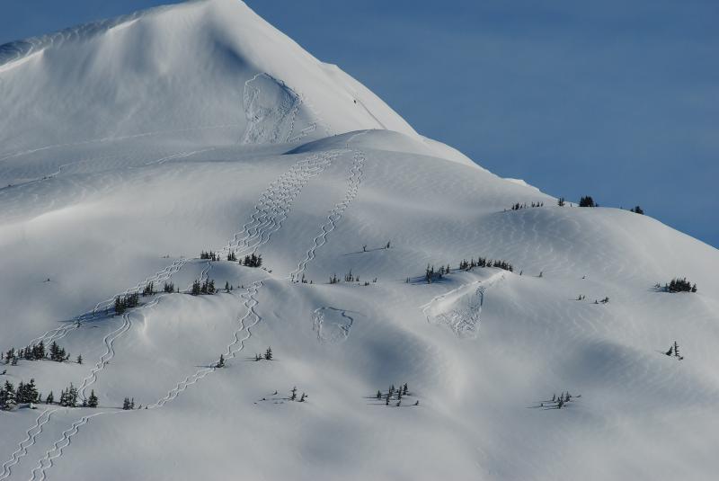
The 6-10+” of snow that fell Friday night through Saturday came in ‘upside down’, due to the increasing temperatures during the storm, creating an unstable storm layer. This new upside down layer fell on top of a sun crust on many east, south and westerly aspects which provided a nice bed surface (the third ingredient for a slab avalanche: slab, weak layer, bed surface). What resulted were many soft slab and wind slabs that were triggered both naturally and by people. I remotely triggered one small slab on a SSE facing slope from 150 feet away. Many of these were shallow due to the modest amount of snow but they were able to propagate quite well. Slabs were also reported on northerly aspects where SE winds likely formed sensitive wind slabs. The sun got to the snow later in the day and wet loose slides began to run in the later afternoon.
Concern #1 – Wet Avalanches
Watch for small to medium, to even large, wet loose avalanches on southerly slopes later in the day today. If the sun comes out in full force it will quickly warm and destabilize the new snow, especially on and under rocky/vegetated slopes. With winds light to non-existent and temperatures WARM, this will add to the impact of the sun that we have not seen the past few weeks.
Concern #2 – Wind Slab and Soft Slab
Today, wind slabs that formed during the storm and soft slabs should be settling out and not quite as easily triggered as they were yesterday. However, they are still POSSIBLE to trigger and there are areas where the new snow fell on surface hoar and in these locations they will still be LIKELY to trigger by a person. These slabs should be fairly shallow, except where winds have deposited snow in deeper slabs on leeward slopes. Additionally, they could have the potential to step down and break into larger avalanches where buried weaknesses exist. Keeping a close eye out for recent avalanches and cracking in the snow around you will be bulls eye clues the snow is still grumpy and unstable.
Concern #3 – Persistent Slab
We still have two weaknesses that reside deeper in the pack: buried surface hoar and facets above a sun crust. The buried surface hoar is 2-3′ deep now and, as Kevin found out a couple days ago, still reactive. Larger avalanches are possible on northerly aspects where a person, or a smaller avalanche could trigger a failure in this deeper layer. Southerly aspects are fairly well tied together with several crusts now but there is one crust that is still producing clean shears about 2-3′ down. If we get very warm temperatures that soften the upper crusts this deeper layer could become reactive, again producing larger and more dangerous avalanches.
MOUNTAIN WEATHER
By mid-day yesterday the snow showers moved out and sunny skies moved in. Temperatures climbed through the storm, and kept climbing as the sun came out, to top out in the low 30’s around treeline and near 20F on the ridges. Winds blew from the East in the 30-40mph range with the snow overnight then dropped off to under 10mph as they turned northwesterly during the day. Storm totals Friday evening through Saturday were roughly:
Turnagain Pass – 5-8″
Girdwood Valley – 6-10″
Summit Lake – 2-3″
Today, partly cloudy to sunny skies are in store with a chance for a flurry or two with clouds moving in and out. Temperatures are forecast to be WARM, mid to upper 30’s near treeline and mid 20’s on the ridgetops. Northerly winds should remain light on the peaks, blowing 5-10mph.
CNFAIC Weather Page and the NWS forecast
Chris will issue the next advisory Monday morning. If you get out in the backcountry we want to know what you are seeing. Please send us your observations using the button at the top of this page or give us a call at 754-2369. Thanks and have a great day.