The avalanche danger is MODERATE above 1000′. Lingering wind slabs up to 2′ deep formed by yesterday’s strong winds will be possible for a person to trigger today. Deeper avalanches on buried weak layers up to 3′ deep are also possible at upper elevations. Below 1000′ the avalanche danger is LOW.
Special Announcements
Become a Member in December – Only a few days left! Please consider becoming a member of our non-profit Friends group. Memberships start at just $20. Every member who joins or renews will be entered to win one of the fabulous prizes from our generous sponsors! Click here for more info.
Fri, December 30th, 2022
Alpine
Above 2,500'
2 - Moderate
Treeline
1,000'-2,500'
2 - Moderate
Below Treeline
Below 1,000'
1 - Low
0 - No Rating
1 - Low
2 - Moderate
3 - Considerable
4 - High
5 - Extreme
Travel Advice
Generally safe avalanche conditions. Watch for unstable snow on isolated terrain features.
Heightened avalanche conditions on specific terrain features. Evaluate snow and terrain carefully; identify features of concern.
Natural avalanches likely; human-triggered avalanches very likely.
Natural and human-triggered avalanches certain.
Avalanche Size and Distribution
Small avalanches in isolated areas or extreme terrain.
Small avalanches in specific areas; or large avalanches in isolated areas.
Small avalanches in many areas; or large avalanches in specific areas; or very large avalanches in isolated areas.
Large avalanches in many areas; or very large avalanches in specific areas.
Very large avalanches in many areas.
Recent Avalanches
The last known avalanche activity was after the last big snow load on Monday (12/26) or Tuesday (12/27). There were several large avalanches along Seattle Ridge, with most activity coming from the southern end of the ridgeline near Peak 4940′. On the skiers side of Turnagain Pass there was an avalanche at lower elevations on Magnum that also looked large enough to bury a person. See ob here for more details.
Avalanche Problem 1
Wind Slabs
Aspect/Elevation
Certain
Very Likely
Likely
Possible
Unlikely
Likelihood
Historic (D4-5)
Very Large (D3)
Large (D2)
Small (D1)
Size
Wind Slabs
Wind Slab avalanches are the release of a cohesive layer of snow (a slab) formed by the wind. Wind typically transports snow from the upwind sides of terrain features and deposits snow on the downwind side. Wind slabs are often smooth and rounded and sometimes sound hollow, and can range from soft to hard. Wind slabs that form over a persistent weak layer (surface hoar, depth hoar, or near-surface facets) may be termed Persistent Slabs or may develop into Persistent Slabs.
Aspect/Elevation of the Avalanche Problem
Specialists develop a graphic representation of the potential distribution of a particular avalanche problem across the topography.
This aspect/elevation rose is used to indicate where the particular avalanche problem is thought to exist on all elevation aspects.
Areas where the avalanche problem is thought to exist are colored grey, and it is less likely to be encountered in areas colored white.
Likelihood of Avalanches
Terms such as "unlikely", "likely", and "certain" are used to define the scale, with the chance of triggering or observing
avalanches increasing as we move up the scale. For our purposes, "Unlikely" means that few avalanches could be triggered in avalanche terrain and
natural avalanches are not expected. "Certain" means that humans will be able to trigger avalanches on many slopes, and natural avalanches are expected.
Size of Avalanches
Avalanche size is defined by the largest potential avalanche, or expected range of sizes related to the problem in question.
Assigned size is a qualitative estimate based on the destructive classification system and requires specialists to estimate the harm avalanches may cause to
hypothetical objects located in the avalanche track (AAA 2016, CAA 2014). Under this schema, "Small" avalanches are not large enough to bury humans and are
relatively harmless unless they carry people over cliffs or through trees or rocks. Moving up the scale, avalanches become "Large" enough to bury, injure,
or kill people. "Very Large" avalanches may bury or destroy vehicles or houses, and "Historic" avalanches are massive events capable of altering the landscape.
East winds averaging 20-30 mph with gusts to 45 mph were building fresh wind slabs up to 2′ deep at upper elevations throughout yesterday. These lingering wind slabs will mostly be an issue in the alpine today, but there is a chance there was enough wind and dry snow around the top of the treeline elevation band to form some wind slabs there as well. To identify wind slabs pay close attention to the snow surface to look for areas that have been recently loaded. Getting off the beaten track to feel the snow surface can be very helpful to get a sense for how the wind redeposited the surface snow in the area you are travelling. Wind slabs will be most likely along upper elevation ridgelines or gully features. In areas sheltered from the winds we still have little information about how the new snow is bonding to the old snow surface. Due to that uncertainty we recommend a conservative approach if you get into the mountains today.
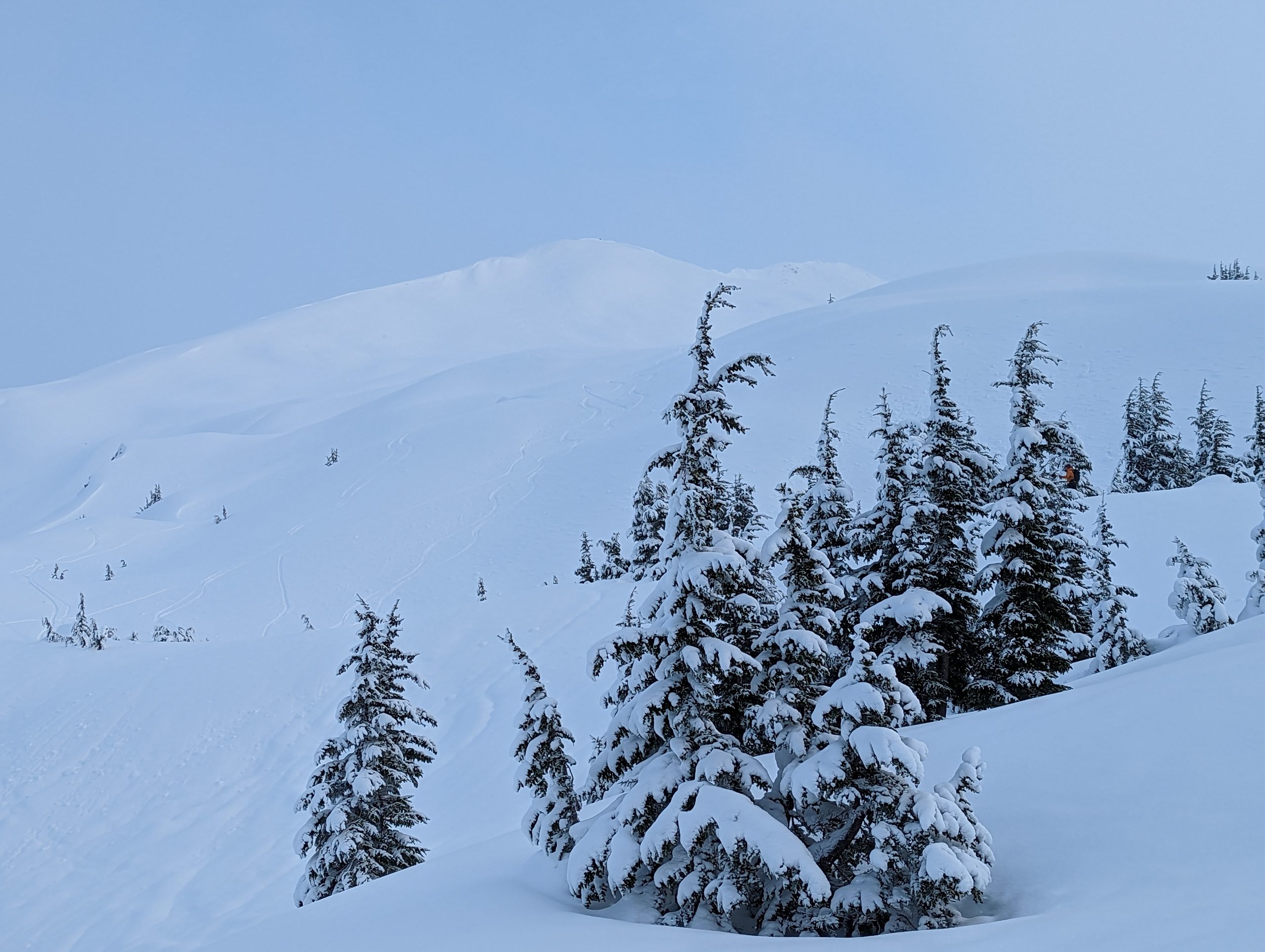
Lingering wind slabs in the upper treeline and alpine elevations are the main concern today. With about 6″ of new snow on the surface at treeline on Wednesday we could see wind slabs up to 2′ deep. Photo 12.28.22
Avalanche Problem 2
Persistent Slabs
Aspect/Elevation
Certain
Very Likely
Likely
Possible
Unlikely
Likelihood
Historic (D4-5)
Very Large (D3)
Large (D2)
Small (D1)
Size
Persistent Slabs
Persistent Slab avalanches are the release of a cohesive layer of snow (a slab) in the middle to upper snowpack, when the bond to an underlying persistent weak layer breaks. Persistent layers include: surface hoar, depth hoar, near-surface facets, or faceted snow. Persistent weak layers can continue to produce avalanches for days, weeks or even months, making them especially dangerous and tricky. As additional snow and wind events build a thicker slab on top of the persistent weak layer, this avalanche problem may develop into a Deep Persistent Slab.
Aspect/Elevation of the Avalanche Problem
Specialists develop a graphic representation of the potential distribution of a particular avalanche problem across the topography.
This aspect/elevation rose is used to indicate where the particular avalanche problem is thought to exist on all elevation aspects.
Areas where the avalanche problem is thought to exist are colored grey, and it is less likely to be encountered in areas colored white.
Likelihood of Avalanches
Terms such as "unlikely", "likely", and "certain" are used to define the scale, with the chance of triggering or observing
avalanches increasing as we move up the scale. For our purposes, "Unlikely" means that few avalanches could be triggered in avalanche terrain and
natural avalanches are not expected. "Certain" means that humans will be able to trigger avalanches on many slopes, and natural avalanches are expected.
Size of Avalanches
Avalanche size is defined by the largest potential avalanche, or expected range of sizes related to the problem in question.
Assigned size is a qualitative estimate based on the destructive classification system and requires specialists to estimate the harm avalanches may cause to
hypothetical objects located in the avalanche track (AAA 2016, CAA 2014). Under this schema, "Small" avalanches are not large enough to bury humans and are
relatively harmless unless they carry people over cliffs or through trees or rocks. Moving up the scale, avalanches become "Large" enough to bury, injure,
or kill people. "Very Large" avalanches may bury or destroy vehicles or houses, and "Historic" avalanches are massive events capable of altering the landscape.
Above the rain line from the last storm (2500 – 3000′) buried persistent weak layers could still be an issue. Prior to the last storm we were seeing skier triggered collapsing on a layer of facets above the Thanksgiving melt freeze crust that was buried about 1.5′ deep. With the addition of the new storm snow that layer is likely closer to 3′ deep now and could produce very large avalanches. In addition, we had weak faceted snow on the surface prior to the last storm on Sunday and Monday that could cause lingering instability at the interface with the new storm snow at upper elevations.
Triggering an avalanche on a deeper persistent weak layer is most likely in areas with a thinner and weaker snowpack. So far this year these conditions have been most prominent in the Girdwood Valley and near the southern end of Turnagain Pass, but it is worthwhile to have this problem on your radar across the forecast region. We recommend paying close attention for any collapsing in the snowpack and taking the time to check the snowpack structure in the area you are travelling to see if this weak structure exists. The best way to mitigate the risk from persistent weak layers is to make conservative terrain choices by sticking to smaller features and lower slope angles.
If the video does not load on your browser click the link here.
Weather
Fri, December 30th, 2022
Yesterday: Moderate to strong E winds persisted throughout the daylight hours yesterday with averages in the 10-20 mph range and gusts up to 45 mph. Light snowfall in coastal areas with 1-2″ falling in Turnagain Pass. Temperatures remained warm, staying above freezing at sea level and just below freezing at about 1000′.
Today: One more day of weak low pressure before the next real storm system moves into the area on Saturday. Light snowfall in coastal areas is expected with minimal accumulation. Winds have decreased overnight and should stay light in the 0-10 mph range with gusts to 15 mph today. Temperatures will remain warm, in the mid thirties at sea level and in the upper to mid twenties at upper elevations. Mid to low level cloud cover is expected to persist throughout the day.
Tomorrow: Another warm storm system is expected to start impacting the forecast area on Saturday. Winds are expected to start ramping up Saturday morning with snowfall starting in the afternoon. Overnight Saturday and into Sunday morning looks like the most intense period of winds and snowfall, with wind speeds in the 35-55 mph range with stronger gusts. By Sunday morning about a foot of new snow is expected in Girdwood and Turnagain Pass areas with closer to two feet in coastal areas like Portage and Placer. Snow line is expected to be in the 500-800′ range on Saturday and then move up to 1000-1500′ on Sunday.
This is a general backcountry avalanche advisory issued for Turnagain Arm with Turnagain Pass as the core advisory area.
This advisory does not apply to highways, railroads or operating ski areas.