Turnagain Pass RSS

Archives
ARCHIVED - Forecasts expire after 24 hours.
Issued
Tue, December 20th, 2022 - 7:00AM
Expires
Wed, December 21st, 2022 - 7:00AM
Forecaster
Andrew Schauer
Avalanche risk The Bottom Line

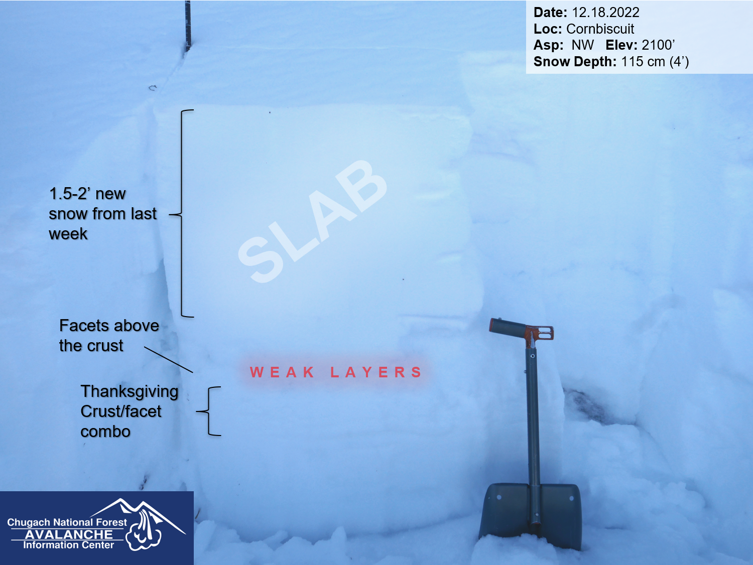
The avalanche danger remains MODERATE today. It is possible for a person to trigger a large avalanche 2-4′ deep on weak faceted snow surrounding a crust that was buried just before Thanksgiving. These large persistent slab avalanches are difficult to predict, and the only way to really manage the problem is by careful terrain management. This means avoiding traveling on or below slopes steeper than 35 degrees.

JOHNSON PASS/LYNX CREEK: We still have no information from these zones, but suspect a weaker snowpack with more dangerous conditions on this southern end of our forecast zone. Cautious route finding is recommended.

SUMMIT LAKE: The snowpack in the Summit Lake area is generally thinner and weaker than Turnagain Pass. This makes human-triggered avalanches more likely, so a little extra caution is warranted in the area.

Special Announcements

Chugach State Park: The snowpack in the mountains closer to Anchorage is showing clear signs that it can produce large avalanches. Be sure to check out the public observations HERE, and use extra caution if you are planning on getting out in this zone. Big thanks to everybody who has been sharing info the past few weeks.

BECOME A MEMBER IN DECEMBER! If you use the forecast, we could use your help! Did you know that the best way to support the Chugach National Forest Avalanche Center is to become a member of the Friends, the cost-share nonprofit that supports our efforts? Memberships start at just $20, and every member who joins or renews will be entered to win one of the fabulous prizes from our sponsors. Make your gift today! Click here for more info.

Tue, December 20th, 2022
Alpine
Above 2,500'
2 - Moderate
Avalanche risk
Treeline
1,000'-2,500'
2 - Moderate
Avalanche risk
Below Treeline
Below 1,000'
2 - Moderate
Avalanche risk
0 - No Rating
1 - Low
2 - Moderate
3 - Considerable
4 - High
5 - Extreme
Avalanche risk Avalanche risk Avalanche risk Avalanche risk Avalanche risk
Travel Advice Generally safe avalanche conditions. Watch for unstable snow on isolated terrain features. Heightened avalanche conditions on specific terrain features. Evaluate snow and terrain carefully; identify features of concern. Dangerous avalanche conditions. Careful snowpack evaluation, cautious route-finding, and conservative decision-making essential. Very dangerous avalanche conditions. Travel in avalanche terrain not recommended. Extraordinarily dangerous avalanche conditions. Avoid all avalanche terrain.
Likelihood of Avalanches Natural and human-triggered avalanches unlikely. Natural avalanches unlikely; human-triggered avalanches possible. Natural avalanches possible; human-triggered avalanches likely. Natural avalanches likely; human-triggered avalanches very likely. Natural and human-triggered avalanches certain.
Avalanche Size and Distribution Small avalanches in isolated areas or extreme terrain. Small avalanches in specific areas; or large avalanches in isolated areas. Small avalanches in many areas; or large avalanches in specific areas; or very large avalanches in isolated areas. Large avalanches in many areas; or very large avalanches in specific areas. Very large avalanches in many areas.
Recent Avalanches

The last reported avalanches in our forecast area were immediately following the 12/14-15 storm event. There were multiple very large avalanches that appear to have failed on the facets near the Thanksgiving crust, with the biggest activity in the Girdwood Valley and on the south end of Turnagain Pass.

Avalanche Problem 1
  • Persistent Slabs
    Persistent Slabs
  • Aspect/Elevation
  • Certain
    Very Likely
    Likely
    Possible
    Unlikely
    Likelihood
  • Historic (D4-5)
    Very Large (D3)
    Large (D2)
    Small (D1)
    Size
Persistent Slabs
Persistent Slab avalanches are the release of a cohesive layer of snow (a slab) in the middle to upper snowpack, when the bond to an underlying persistent weak layer breaks. Persistent layers include: surface hoar, depth hoar, near-surface facets, or faceted snow. Persistent weak layers can continue to produce avalanches for days, weeks or even months, making them especially dangerous and tricky. As additional snow and wind events build a thicker slab on top of the persistent weak layer, this avalanche problem may develop into a Deep Persistent Slab.

Aspect/Elevation of the Avalanche Problem
Specialists develop a graphic representation of the potential distribution of a particular avalanche problem across the topography. This aspect/elevation rose is used to indicate where the particular avalanche problem is thought to exist on all elevation aspects. Areas where the avalanche problem is thought to exist are colored grey, and it is less likely to be encountered in areas colored white.

Likelihood of Avalanches
Terms such as "unlikely", "likely", and "certain" are used to define the scale, with the chance of triggering or observing avalanches increasing as we move up the scale. For our purposes, "Unlikely" means that few avalanches could be triggered in avalanche terrain and natural avalanches are not expected. "Certain" means that humans will be able to trigger avalanches on many slopes, and natural avalanches are expected.

Size of Avalanches
Avalanche size is defined by the largest potential avalanche, or expected range of sizes related to the problem in question. Assigned size is a qualitative estimate based on the destructive classification system and requires specialists to estimate the harm avalanches may cause to hypothetical objects located in the avalanche track (AAA 2016, CAA 2014). Under this schema, "Small" avalanches are not large enough to bury humans and are relatively harmless unless they carry people over cliffs or through trees or rocks. Moving up the scale, avalanches become "Large" enough to bury, injure, or kill people. "Very Large" avalanches may bury or destroy vehicles or houses, and "Historic" avalanches are massive events capable of altering the landscape.

Signal Word Size (D scale) Simple Descriptor
Small 1 Unlikely to bury a person
Large 2 Can bury a person
Very Large 3 Can destroy a house
Historic 4 & 5 Can destroy part or all of a village
More info at Avalanche.org

With another day of quiet weather on the way today, our main avalanche concern is the potential for a person to trigger a persistent slab avalanche 2-4′ deep on weak, faceted snow surrounding a crust that formed back before Thanksgiving. Without a significant load in the past 5 days this layer is becoming more stubborn to trigger, but it still cannot be trusted. It seems the most concerning zones within our forecast area are the mountains around Girdwood and towards the south end of Turnagain Pass. From the observations we have received over the past week, there is also cause for concern outside of our forecast area in Chugach State Park and in the Summit Lake area.

This is a tough problem to manage. These deeper persistent weak layers do not always give clear warning signs of instability even though there is still a very real possibility that a person can trigger a large avalanche. On the one hand we are still getting concerning test results in our pits (details here), but on the other there are tracks in steep terrain all over the pass. The problem with these stubborn persistent weak layers is that they can give you this mixed feedback even though they are still dangerous. These avalanches have a tendency to release after there are multiple sets of tracks on a slope. They can also be triggered remotely from below, above, or next to steeper terrain. At this point, the weak layer is stubborn, but not unreactive. Before moving into or below steep terrain, think about whether the terrain you’re considering matches the current snowpack. Is there an escape route if the slope does release, or are you traveling on a big, connected slope? If you are getting into steep terrain, does it have a planar runout, or are there terrain traps like gullies, cliffs, or trees below you that increase the consequences if you do get caught in a slide? Unfortunately these layers take a long time to heal, so it is looking like we are going to be dealing with this for some time to come. The good news is that you can avoid the problem entirely by sticking to slopes that are less than 35 degrees.

Dry Loose Avalanches: There is plenty of loose, dry snow on the surface that will be ready to sluff in steep terrain. While these avalanches are unlikely to be big enough to bury a person, they can still be dangerous if they catch you in consequential terrain. Pay attention to sluffing on steep slopes, and work across the fall line to avoid getting caught by surprise.

 This is the setup that is giving us cause for concern- a thick slab sitting on top of multiple weak layers of facets. This photo is from Cornbiscuit, but the poor structure is consistent throughout the advisory area and beyond. It seems the weakest zones are near Girdwood and towards the south end of Turnagain Pass. 12.18.2022

This very large avalanche in the Summit Lake area illustrates the problem at hand. This was a natural avalanche that likely occurred late last week, but it is still possible to trigger something like this today. Photo: Paul Wunnicke. 12.19.2022

Weather
Tue, December 20th, 2022

Yesterday: Skies started mostly clear, with increasing clouds during the day. Temperatures were in the single digits to mid teens F during the day, with single digits above and below 0 F overnight. Winds were light at 5-10 mph out of the east for most of the day with a few hours of light westerly winds overnight. Light flurries brought a trace of snow to Girdwood overnight, but no measurable precipitation at any of the weather stations.

Today: Temperatures are expected to get into the mid to upper teens F under increasing cloud cover. Winds should be light at 5-10 mph with gusts of 10-15 mph out of the east. We might see a few snowflakes, but it is not looking like any significant precipitation.

Tomorrow: Easterly winds are expected to increase to 10-20 mph as a low pressure system that has been hanging out near Cordova makes its way a little further into Prince Willliam Sound. Skies will be mostly cloudy, with a chance for a few more snowflakes. Temperatures should be around 20 F during the day, and dip into the upper teens overnight. It is looking like we might pick 2-4″ snow overnight Wednesday into Thursday.

PRECIPITATION 24-hour data (6am – 6am)

Temp Avg (F) Snow (in) Water (in) Snow Depth (in)
Center Ridge (1880′) 8 0 0 37
Summit Lake (1400′) 2 0 0 28
Alyeska Mid (1700′) 10 0 0 40
Bear Valley – Portage (132′) 5 0 0

RIDGETOP 24-hour data (6am – 6am)

Temp Avg (F) Wind Dir Wind Avg (mph) Wind Gust (mph)
Sunburst (3812′) 7 E 4 17
Seattle Ridge (2400′) 10 E 3 8
Observations
Recent Observations for Turnagain Pass
Date Region Location
04/21/24 Turnagain Observation: Bertha Creek
04/20/24 Turnagain Avalanche: Spokane Creek
04/16/24 Turnagain Observation: Cornbiscuit
04/15/24 Turnagain Observation: Taylor Pass
04/15/24 Turnagain Observation: Seward Highway – Tern Lake to Portage
04/14/24 Turnagain Observation: Sunburst
04/14/24 Turnagain Observation: Turnagain Pass Snomo
04/13/24 Turnagain Observation: Spokane Creek
04/11/24 Turnagain Observation: Tincan
04/10/24 Turnagain Avalanche: Seattle Ridge
Riding Areas

The riding areas page has moved. Please click here & update your bookmarks.


Subscribe to Turnagain Pass
Avalanche Forecast by Email

This is a general backcountry avalanche advisory issued for Turnagain Arm with Turnagain Pass as the core advisory area. This advisory does not apply to highways, railroads or operating ski areas.