Turnagain Pass RSS

Archives
ARCHIVED - Forecasts expire after 24 hours.
Issued
Tue, December 13th, 2022 - 7:00AM
Expires
Wed, December 14th, 2022 - 7:00AM
Forecaster
Andrew Schauer
Avalanche risk The Bottom Line

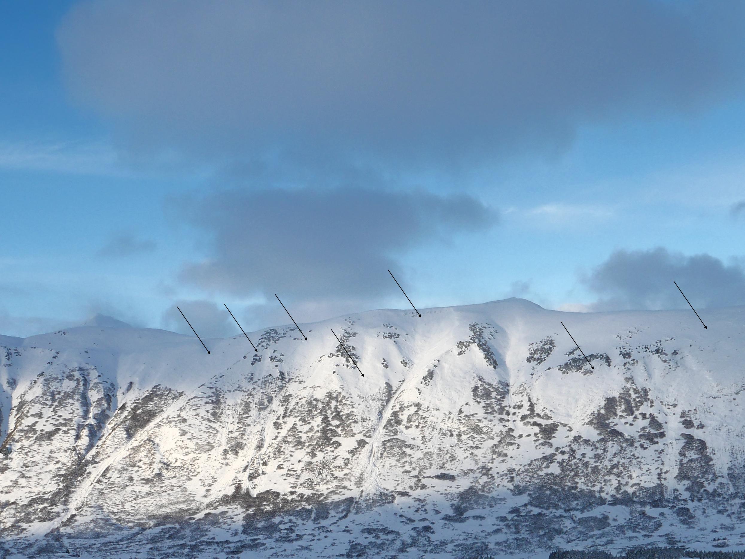
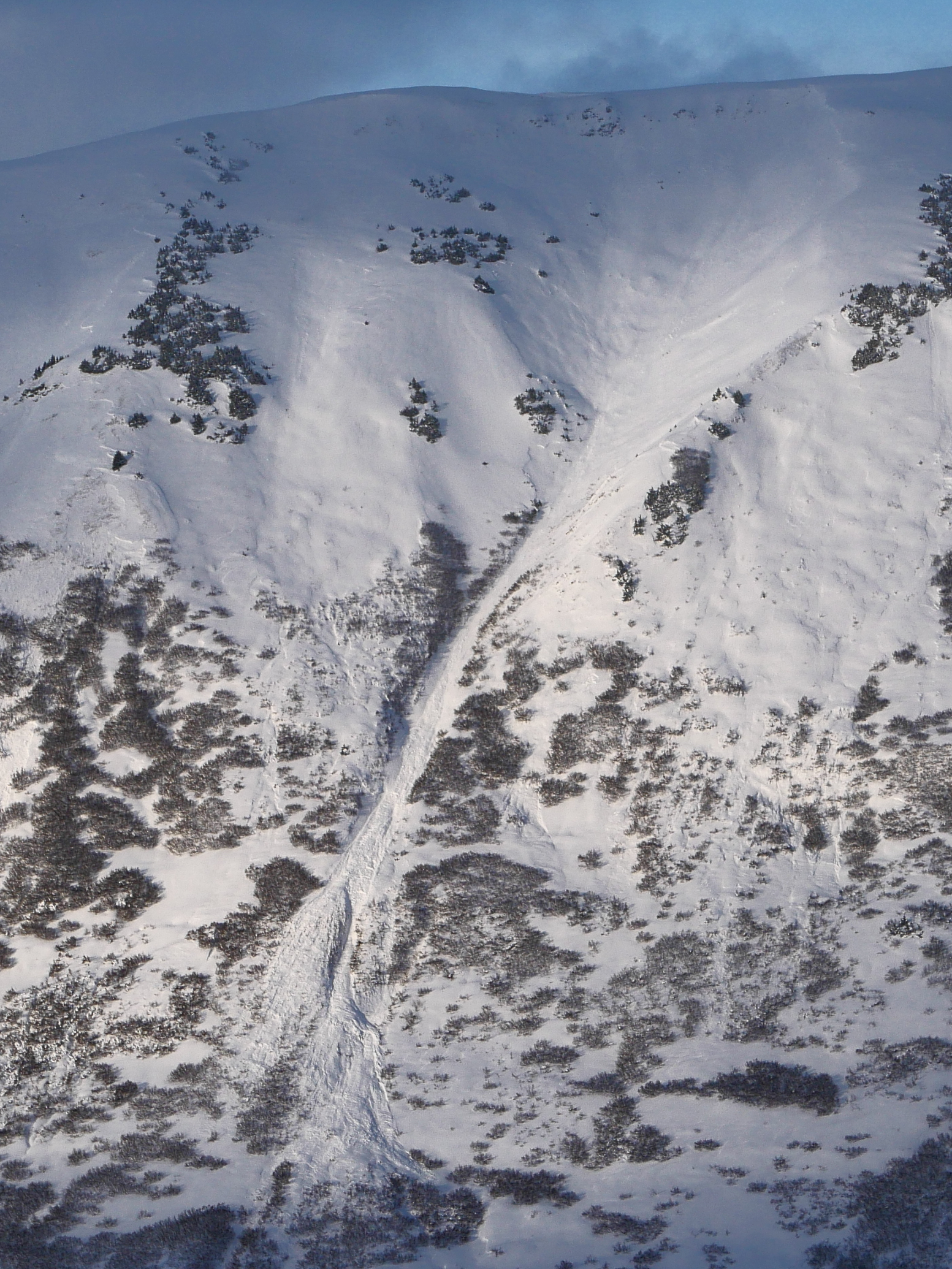
The avalanche danger is CONSIDERABLE above 1000′. With 1.5-2′ soft snow on the ground from yesterday and moderate southerly winds today, human-triggered avalanches 2-3′ deep are likely and natural avalanches possible. Be cautious with terrain selection today, avoiding steep wind-loaded slopes near ridgelines, convexities, and gullies. The danger is MODERATE below 1000′, where it is still possible to trigger an avalanche, but lighter winds will mean conditions won’t be quite as reactive as in the mid and upper elevations.

SUMMIT LAKE: Yesterday’s big loading event is adding a lot of stress to a weak snowpack in the Summit Lake area. Extra caution is warranted if you are getting out in this zone.

Special Announcements

Some motorized areas are opening today! For the Glacier district, this includes Johnson Pass and Turnagain Pass. Skookum, Placer and Twentymile will remain closed. Everything in the Seward district will open except for the Resurrection Pass Trail, which is closed to motorized use for 2022/23 and will be open again next season. See our riding tab below for more information on closures.  Parking may be a challenge following the recent storm– be sure to give plowing equipment plenty of space as they clear the roads and parking lots for us.

Forecaster Chat #1: Come join forecaster John Sykes at Alaska Mountaineering and Hiking from 7-8 pm this Thursday, December 15th to discuss current conditions, how to submit quick and quality observations, and decision-making during complex snowpack conditions. Admission is free and all are welcome!

Tue, December 13th, 2022
Alpine
Above 2,500'
3 - Considerable
Avalanche risk
Treeline
1,000'-2,500'
3 - Considerable
Avalanche risk
Below Treeline
Below 1,000'
2 - Moderate
Avalanche risk
0 - No Rating
1 - Low
2 - Moderate
3 - Considerable
4 - High
5 - Extreme
Avalanche risk Avalanche risk Avalanche risk Avalanche risk Avalanche risk
Travel Advice Generally safe avalanche conditions. Watch for unstable snow on isolated terrain features. Heightened avalanche conditions on specific terrain features. Evaluate snow and terrain carefully; identify features of concern. Dangerous avalanche conditions. Careful snowpack evaluation, cautious route-finding, and conservative decision-making essential. Very dangerous avalanche conditions. Travel in avalanche terrain not recommended. Extraordinarily dangerous avalanche conditions. Avoid all avalanche terrain.
Likelihood of Avalanches Natural and human-triggered avalanches unlikely. Natural avalanches unlikely; human-triggered avalanches possible. Natural avalanches possible; human-triggered avalanches likely. Natural avalanches likely; human-triggered avalanches very likely. Natural and human-triggered avalanches certain.
Avalanche Size and Distribution Small avalanches in isolated areas or extreme terrain. Small avalanches in specific areas; or large avalanches in isolated areas. Small avalanches in many areas; or large avalanches in specific areas; or very large avalanches in isolated areas. Large avalanches in many areas; or very large avalanches in specific areas. Very large avalanches in many areas.
Recent Avalanches

Yesterday we got eyes on some of the activity on Turnagain Pass when the skies started to clear up in the afternoon. From what we could see, there was one fairly large avalanche on the south face of Sunburst, and at least 10 large avalanches on the front side of Seattle Ridge (more info in our observation from Tincan yesterday). It was hard to tell if these avalanches only involved the new snow or if they had stepped down to weaker snow around the Thanksgiving crust layer.

A handful of the avalanches we saw on Seattle Ridge yesterday. 12.12.2022

Zoomed-in view of the debris from one of the Seattle Ridge avalanches. The crown is difficult to make out in the shadow, but it probably spans a good portion of the bowl just below the ridgeline. 12.12.2022

Avalanche Problem 1
  • Wind Slabs
    Wind Slabs
  • Aspect/Elevation
  • Certain
    Very Likely
    Likely
    Possible
    Unlikely
    Likelihood
  • Historic (D4-5)
    Very Large (D3)
    Large (D2)
    Small (D1)
    Size
Wind Slabs
Wind Slab avalanches are the release of a cohesive layer of snow (a slab) formed by the wind. Wind typically transports snow from the upwind sides of terrain features and deposits snow on the downwind side. Wind slabs are often smooth and rounded and sometimes sound hollow, and can range from soft to hard. Wind slabs that form over a persistent weak layer (surface hoar, depth hoar, or near-surface facets) may be termed Persistent Slabs or may develop into Persistent Slabs.

Aspect/Elevation of the Avalanche Problem
Specialists develop a graphic representation of the potential distribution of a particular avalanche problem across the topography. This aspect/elevation rose is used to indicate where the particular avalanche problem is thought to exist on all elevation aspects. Areas where the avalanche problem is thought to exist are colored grey, and it is less likely to be encountered in areas colored white.

Likelihood of Avalanches
Terms such as "unlikely", "likely", and "certain" are used to define the scale, with the chance of triggering or observing avalanches increasing as we move up the scale. For our purposes, "Unlikely" means that few avalanches could be triggered in avalanche terrain and natural avalanches are not expected. "Certain" means that humans will be able to trigger avalanches on many slopes, and natural avalanches are expected.

Size of Avalanches
Avalanche size is defined by the largest potential avalanche, or expected range of sizes related to the problem in question. Assigned size is a qualitative estimate based on the destructive classification system and requires specialists to estimate the harm avalanches may cause to hypothetical objects located in the avalanche track (AAA 2016, CAA 2014). Under this schema, "Small" avalanches are not large enough to bury humans and are relatively harmless unless they carry people over cliffs or through trees or rocks. Moving up the scale, avalanches become "Large" enough to bury, injure, or kill people. "Very Large" avalanches may bury or destroy vehicles or houses, and "Historic" avalanches are massive events capable of altering the landscape.

Signal Word Size (D scale) Simple Descriptor
Small 1 Unlikely to bury a person
Large 2 Can bury a person
Very Large 3 Can destroy a house
Historic 4 & 5 Can destroy part or all of a village
More info at Avalanche.org

The storm that finished yesterday morning dropped 1.5-2′ of snow across the area, and was followed by strong northwesterly winds. For most of our core advisory area, winds were around 10-15 mph with gusts at 25-35 mph, but other stations around the edges of our advisory area were showing sustained speeds of 25-50 mph and gusts up to 109 mph. The winds have switched overnight, currently blowing out of the east and expected to be out of the south for most of the day. Although it is looking like speeds will decrease to around 5-15 mph, there is still plenty of snow on the ground waiting to be blown into fresh wind slabs. This recent storm had an average density of 8-9%, which is really light for us. Even if the winds aren’t getting wild today, they should still be able to move some of that light fluffy snow. The change in wind direction means that you could find reactive wind slabs on any aspect today. Slabs that formed yesterday will be larger, but more stubborn than fresh slabs forming today. We saw avalanche debris in lower runout zones while we were out yesterday, and similar activity is possible today.

Dangerous avalanche conditions will continue today, which requires cautious route finding. Be wary of wind-loaded slopes with stiffer snow on the surface, especially near ridgelines, in gullies or on convex rollovers. Take a few seconds to step off the skin track or hop off your snowmachine to see what the surface snow feels like. If you notice stiff snow on top of soft snow, you’ve got a potentially dangerous combination. Today is a day to be conservative with terrain use.

With a lot of motorized zones opening today, there is a good chance people are getting to places where nobody has been so far this year. This is another reason to build in a wider margin of safety, and carefully assess conditions as you travel. If you do get into new zones today, take a minute to let us know what you see by submitting on observation here.

Outflow winds moving a lot of snow off Blueberry Hill yesterday afternoon. There was a similar scene on top of Pyramid and a good portion of Seattle Ridge as well. 12.12.2022

Click here to view the video below if it doesn’t load in your browser.


Weather
Tue, December 13th, 2022

Yesterday: Snowfall tapered off early in the morning, and skies gradually cleared through the day. Sustained northwest winds were blowing 10-20 mph at Turnagain Pass, but the Mile 43 weather station was recording sustained speeds of 45-50 mph and gusts as high as 109 mph. Temperatures dropped during the day from the upper 20’s F in the morning to single digits F overnight.

Today: A weak system will bring a trace to 3″ new snow to the advisory area today, favoring the Girdwood zone over Turnagain Pass. Southerly winds will be around 5-15 mph with gusts at 10-20. Skies will be mostly cloudy with high temperatures in the mid 20’s F and lows in the high teens to low 20’s F. The snow line should stay down at sea level today.

Tomorrow: Another, stronger system will move into the area late tomorrow. We are expecting 2-4″ during the day, with 6-8″ overnight for Turnagain and Girdwood. Winds will pick up as snowfall intensity increases, with sustained speeds of 10-15 mph and gusts of 15-20 mph out of the southeast. High temperatures will reach the mid 20’s to low 30’s F, with lows in the high teens to mid 20’s F. The rain line will start out down at sea level but creep up to around 1000′ as the storm continues through Wednesday night.

PRECIPITATION 24-hour data (6am – 6am)

Temp Avg (F) Snow (in) Water (in) Snow Depth (in)
Center Ridge (1880′) 22 0 0 46
Summit Lake (1400′) 13 1 0.1 33
Alyeska Mid (1700′) 21 tr tr 45
Bear Valley (132′) 21 2 0.27

RIDGETOP 24-hour data (6am – 6am)

Temp Avg (F) Wind Dir Wind Avg (mph) Wind Gust (mph)
Sunburst (3812′) 13 NW-NE 8 36
Seattle Ridge (2400′) 17 NW-SE 9 27
Observations
Recent Observations for Turnagain Pass
Date Region Location
04/16/24 Turnagain Observation: Cornbiscuit
04/15/24 Turnagain Observation: Taylor Pass
04/15/24 Turnagain Observation: Seward Highway – Tern Lake to Portage
04/14/24 Turnagain Observation: Sunburst
04/14/24 Turnagain Observation: Turnagain Pass Snomo
04/13/24 Turnagain Observation: Spokane Creek
04/11/24 Turnagain Observation: Tincan
04/10/24 Turnagain Avalanche: Seattle Ridge
04/10/24 Turnagain Observation: Cornbiscuit South Face
04/10/24 Turnagain Avalanche: Tincan
Riding Areas

The riding areas page has moved. Please click here & update your bookmarks.


Subscribe to Turnagain Pass
Avalanche Forecast by Email

This is a general backcountry avalanche advisory issued for Turnagain Arm with Turnagain Pass as the core advisory area. This advisory does not apply to highways, railroads or operating ski areas.