Turnagain Pass Avalanche Forecast
|
![]() ![]() |
The avalanche danger remains MODERATE in the Alpine due to a buried layer of faceted snow that sits 2-3′ below the snow surface. This layer is still showing signs that an avalanche could be triggered on steep slopes at the high elevations above 3,000′. Below 3,000′ there is a LOW avalanche danger.
*Avalanche danger expected to rise through the weekend in sync with a strong warm storm moving in.
Join CNFAIC Forecaster Aleph Johnston-Bloom at Blue & Gold Boardshop Monday, Dec 9th, 7:00-8:30 for a FREE evening avalanche discussion on patterns in Alaskan avalanche accidents with practical takeaways to use this season. There will also be an avalanche gear demo outside in the snow (weather permitting).
Signal Word | Size (D scale) | Simple Descriptor |
Small | 1 | Unlikely to bury a person |
Large | 2 | Can bury a person |
Very Large | 3 | Can destroy a house |
Historic | 4 & 5 | Can destroy part or all of a village |
Today should be our last day of cold temperatures before our weather does a complete 180 on us. A large scale system with strong southerly flow is headed in this evening and will bring considerably rising temperatures, gale force winds and heavy precipitation through the weekend. Rain could make it above 2,500′ by Sunday and another pulse looks to pump more warm air and moisture in for Monday and Tuesday. After today, expect rising avalanche danger, wet soggy snow along Turnagain Pass, and if we are lucky, the rain line will not reach our ridgetops. Stay tuned for more details on precip numbers tomorrow morning.
For today however, we are still in a similar avalanche pattern. Our main concern is at the upper elevations above 3,000′ where a person could trigger an avalanche 2-3′ thick breaking near the ground. If skies are clear enough to travel above 3,000′, keep in mind there is a potential weak layer of facets lurking under you. There could be no signs of instability before a slope cracks and releases. Unfortunately, snowpack tests continue to show reactivity in a weak layer of facets just above hard crust. This is keeping our hackles up on high alpine slopes.
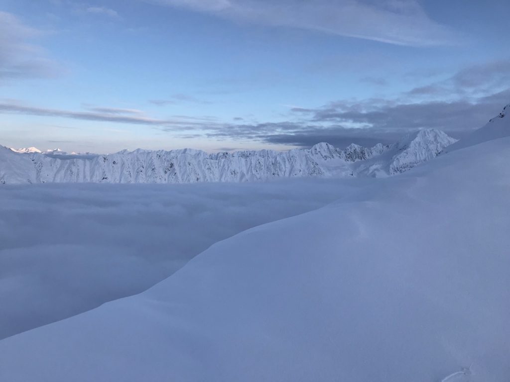
High elevation terrain, pictured above, is where our avalanche concerns exist.
Snow pit at 3,200′ on Sunburst shows a thinner section of the snowpack (2.5 feet total depth) and thinner section of the slab (1.5 feet). This pit had the most reactive and concerning stability test results and tells us this layer of faceted snow could create an avalanche.
Yesterday: Partly cloudy skies were over the region with a trace of snow overnight in areas near Turnagain Arm. Winds shifted from the NW to the east in the morning and have been averaging near 5mph with gusts in the mid-teens. The wind shift brought slightly warmer temperatures, mid-teens along the ridgelines and the low 20’s at the lower elevations.
Today: Partly cloudy skies, slowly warming temperatures and scattered light snow showers are forecast (to sea level). Only a trace to 2″ of snow is expected today along with a chance for 2-4″ of snow tonight. Winds will continue from an easterly direction and pick up into the 15-25mph range along ridgetops before increasing tonight to the 30-40 mph. Temperatures should rise to the 20’s F at the high elevations (4,000′) and close to 30 F at the low elevations (1,000′).
Tomorrow: A strong weather system and significant warming trend is on tap for the weekend and into early next week. Heavy snow and rain at sea level is expected along the eastern Kenai and western Prince William Sound. Seward is expected to see several inches of rainfall and Girdwood up to an inch tomorrow. Snow should make it to 1,000′ tomorrow but then turn to rain on Sunday with the snow line rising to 2,000′ or higher by Monday. We’ll be keeping close tabs on this storm so stay tuned!
PRECIPITATION 24-hour data (6am – 6am)
Temp Avg (F) | Snow (in) | Water (in) | Snow Depth (in) | |
---|---|---|---|---|
Center Ridge (1880′) | 18 | 0 | 0 | 15 |
Summit Lake (1400′) | 15 | 0 | 0 | 9 |
Alyeska Mid (1700′) | 17 | 0 | 0 | 18 |
RIDGETOP 24-hour data (6am – 6am)
Temp Avg (F) | Wind Dir | Wind Avg (mph) | Wind Gust (mph) | |
---|---|---|---|---|
Sunburst (3812′) | 14 | NE | 5 | 12 |
Seattle Ridge (2400′) | N/A* | N/A* | N/A* | N/A* |
*Seattle Ridge anemometer (wind sensor) is rimed over and the temperature sensor is not functioning. A new temperature sensor is arriving soon and we hope to get it up on the next clear day.
Date | Region | Location | Observer |
---|---|---|---|
05/22/23 | Turnagain | Avalanche: Tincan | Nick D'Alessio |
05/12/23 | Turnagain | Avalanche: Tincan, Sunburst, Magnum, Cornbiscuit | Heather Thamm |
05/07/23 | Turnagain | Observation: Tincan – Bear Tracks | CNFAIC Staff |
05/05/23 | Turnagain | Observation: Seattle Ridge | AS/ WW Forecaster |
05/02/23 | Turnagain | Observation: Cornbiscuit | Schauer/ Sturgess Forecaster |
05/02/23 | Turnagain | Observation: Seward Hwy Turnagain Pass | Joel Curtis |
04/30/23 | Turnagain | Observation: Magnum | Ayla, Kit Crosby, Barton |
04/29/23 | Turnagain | Observation: Tincan | John Sykes |
04/28/23 | Turnagain | Avalanche: Taylor Pass/Pastoral | Schauer/ Creighton Forecaster |
04/28/23 | Turnagain | Avalanche: Tincan | Andy Moderow |
Status of riding areas across the Chugach NF is managed by the Glacier and Seward Ranger Districts, not avalanche center staff. Riding area information is posted as a public service to our users and updated based on snow depth and snow density to prevent resource damage at trailhead locations. Riding area questions contact: mailroom_r10_chugach@fs.fed.us
Area | Status | Weather & Riding Conditions |
---|---|---|
Glacier District |
Subscribe to Turnagain Pass
Avalanche Forecast by Email
This is a general backcountry avalanche advisory issued for Turnagain Arm with Turnagain Pass as the core advisory area. This advisory does not apply to highways, railroads or operating ski areas.