Turnagain Pass Avalanche Forecast
|
![]() ![]() |
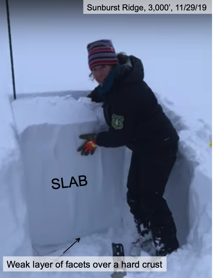
A MODERATE avalanche danger exists above 2,500′. Triggering a large, dangerous avalanche remains possible due to a suspect weak layer/ bed surface combination near the ground. In addition, be on the lookout for lingering small wind slabs particularly along or just below leeward ridges.
Join CNFAIC Forecaster Aleph Johnston-Bloom at Blue & Gold Boardshop Monday, Dec 9th, 7:00-8:30 for a FREE evening avalanche discussion on patterns in Alaskan avalanche accidents with practical takeaways to use this season. There will also be an avalanche gear demo outside in the snow (weather permitting).
Headed to Hatcher Pass? Don’t forget to check hpavalanche.org and their Facebook page!
Signal Word | Size (D scale) | Simple Descriptor |
Small | 1 | Unlikely to bury a person |
Large | 2 | Can bury a person |
Very Large | 3 | Can destroy a house |
Historic | 4 & 5 | Can destroy part or all of a village |
With clearing skies today and improving surface conditions, if you travel farther and higher into favorite zones across the advisory area, please use caution. There is still limited data above 3000′ and evidence that there maybe a dangerous facet/crust combination near the base of the snowpack in the Alpine. Forecasters and observers have found this set-up to be reactive in some snow pits and it was responsible for a very large whumpf with shooting cracks on Sunburst ridge last weekend. The buried crust seems to be widespread throughout the Turnagain area but the presence of the weak, faceted snow above remains the question mark. How widespread the facet layer is such an unknown and due to the reality that there has been essentially zero slope testing, higher elevation slopes should not be trusted. Signs of instability may not be present, this type of avalanche may let you get out onto the slope before it fails and unfortunately it might not be the first rider that triggers it.
Signal Word | Size (D scale) | Simple Descriptor |
Small | 1 | Unlikely to bury a person |
Large | 2 | Can bury a person |
Very Large | 3 | Can destroy a house |
Historic | 4 & 5 | Can destroy part or all of a village |
If you travel into the Alpine be on the lookout for wind effect in along ridgelines, especially in areas that load with a west wind. The frontside a.k.a the Sunnyside of Seattle ridge is one of those zones. Lingering wind slabs on the leeward slopes are still possible today. Winds were mostly light yesterday but the previous day they were stronger. There may be hard snow under the fluff. Look for cracking, listen for hollow sounding snow and pole probe for hard snow over soft snow. Even small winds slabs can have high consequences in steep terrain.
Yesterday: Skies were mostly cloudy with light snow showers. Temperatures were in the high teens to mid 20Fs. Winds were light and westerly.
Today: Mostly cloudy to partly sunny skies with a chance of light snow showers in the morning. There maybe patchy valley fog as skies clear. Temperatures will start in the high teens to mid 20Fs and drop throughout today. Overnight temperatures are forecast to be in the low teens and single digits. Winds will remain light and westerly. Freezing valley fog may develop overnight.
Tomorrow: Partly sunny skies with temperatures in the high teens and mid 20Fs. Light variable winds. Clouds move back in overnight with a chance of snow as the next front approaches.
PRECIPITATION 24-hour data (6am – 6am)
Temp Avg (F) | Snow (in) | Water (in) | Snow Depth (in) | |
---|---|---|---|---|
Center Ridge (1880′) | 18 | trace | 0.02 | 16 |
Summit Lake (1400′) | 17 | 0 | 0 | 10 |
Alyeska Mid (1700′) | 19 | 0.5 | 0.04 | 18 |
RIDGETOP 24-hour data (6am – 6am)
Temp Avg (F) | Wind Dir | Wind Avg (mph) | Wind Gust (mph) | |
---|---|---|---|---|
Sunburst (3812′) | 12 | W | 2 | 5 |
Seattle Ridge (2400′) | NA* | NA* | NA* | NA* |
*Seattle Ridge wind sensor is rimed over and the temperature sensor is not functioning.
Date | Region | Location | Observer |
---|---|---|---|
05/22/23 | Turnagain | Avalanche: Tincan | Nick D'Alessio |
05/12/23 | Turnagain | Avalanche: Tincan, Sunburst, Magnum, Cornbiscuit | Heather Thamm |
05/07/23 | Turnagain | Observation: Tincan – Bear Tracks | CNFAIC Staff |
05/05/23 | Turnagain | Observation: Seattle Ridge | AS/ WW Forecaster |
05/02/23 | Turnagain | Observation: Cornbiscuit | Schauer/ Sturgess Forecaster |
05/02/23 | Turnagain | Observation: Seward Hwy Turnagain Pass | Joel Curtis |
04/30/23 | Turnagain | Observation: Magnum | Ayla, Kit Crosby, Barton |
04/29/23 | Turnagain | Observation: Tincan | John Sykes |
04/28/23 | Turnagain | Avalanche: Taylor Pass/Pastoral | Schauer/ Creighton Forecaster |
04/28/23 | Turnagain | Avalanche: Tincan | Andy Moderow |
Status of riding areas across the Chugach NF is managed by the Glacier and Seward Ranger Districts, not avalanche center staff. Riding area information is posted as a public service to our users and updated based on snow depth and snow density to prevent resource damage at trailhead locations. Riding area questions contact: mailroom_r10_chugach@fs.fed.us
Area | Status | Weather & Riding Conditions |
---|---|---|
Glacier District |
Subscribe to Turnagain Pass
Avalanche Forecast by Email
This is a general backcountry avalanche advisory issued for Turnagain Arm with Turnagain Pass as the core advisory area. This advisory does not apply to highways, railroads or operating ski areas.