Turnagain Pass Avalanche Forecast
|
![]() ![]() |
The avalanche danger is MODERATE at all elevations. Cooler temperatures and cloud cover should make wet avalanches less likely than yesterday, but they are still possible in the afternoon especially at lower elevations and on steep south and west facing terrain. The snowpack remains dry and cold above treeline on north facing slopes, and the potential for triggering a deeply buried persistent weak layer still exists. Triggering an avalanche on a persistent weak layer 3-6′ deep is unlikely but the consequences are high, so we recommend conservative terrain selection if you are seeking out high and dry snow conditions.
PORTAGE VALLEY hikers/bikers/xc skiers: Be aware of avalanches occurring overhead as the day heats up. This area can see large wet slides that can run close to commonly traveled areas.
The gradual onset of spring wet avalanches continued yesterday with some larger wet loose and a few wet slab avalanches observed in Girdwood, Turnagain Pass, and Portage Area. With temperatures climbing into the 50s F at sea level and sunny skies there was a lot of melt going on in the snowpack yesterday.
Wet slab avalanche that released on the SW face of Pete’s S (ob here). Photo 4.21.23 from Michael Kerst
Another wet slab from a SW aspect near Explorer Peak in the Skookum Glacier area. Photo 4.21.23 from Matt Mckee
Wet avalanche debris along Penguin Ridge near Girdwood that looks like it started as a wet loose/point release and entrained lots of wet snow on the way down. Photo 4.21.23
Signal Word | Size (D scale) | Simple Descriptor |
Small | 1 | Unlikely to bury a person |
Large | 2 | Can bury a person |
Very Large | 3 | Can destroy a house |
Historic | 4 & 5 | Can destroy part or all of a village |
Just as things were starting to get interesting, with wet slab avalanches observed yesterday on Pete’s S and in the Skookum Glacier area, the weather is reverting back to colder temperatures and cloudy skies. Highs are expected to stay in the low 30s F in the alpine today and mid to high 30s F at lower elevations. This should make wet avalanches much less likely today, but depending on how much sun finds it’s way through the cloud cover we could still see melting crusts in the afternoon and potential for wet loose avalanches especially at lower elevations and on steep southern aspects. Keep an eye out for roller balls, natural wet loose avalanches, and wet surface snow conditions as indicators of wet avalanche conditions.
Our main concern for human triggered avalanches continues to be the low likelihood but potentially high consequence scenario of finding a deeply buried persistent weak layer on shaded northern aspects which continue to hold dry snow. Earlier this week a group of skiers in Virgin Creek in Girdwood triggered a large avalanche ranging from 2-6′ deep on a steep NW aspect (see ob here). This was very unexpected since the last avalanche triggered on our deeply buried weak layer from mid-March was about three weeks ago and we have had little significant weather recently.
While we continue to believe that triggering an avalanche like this is unlikely, the possibility increases the potential consequences of seeking out steep high elevation north facing terrain. In a typical year this would be the time where conditions are prime for tackling larger objectives, but we have seen multiple close calls this week with skiers triggering avalanches and being carried over cliffs through complex terrain. The take home message is that our snowpack has some atypical weak layers this spring that make venturing into big terrain higher risk than most years.
Other hazards associated with the spring melt cycle include cornice fall and glide avalanche release, which are both very unpredictable and can produce large avalanches. We recommend minimizing time spent underneath large cornices or glide cracks.
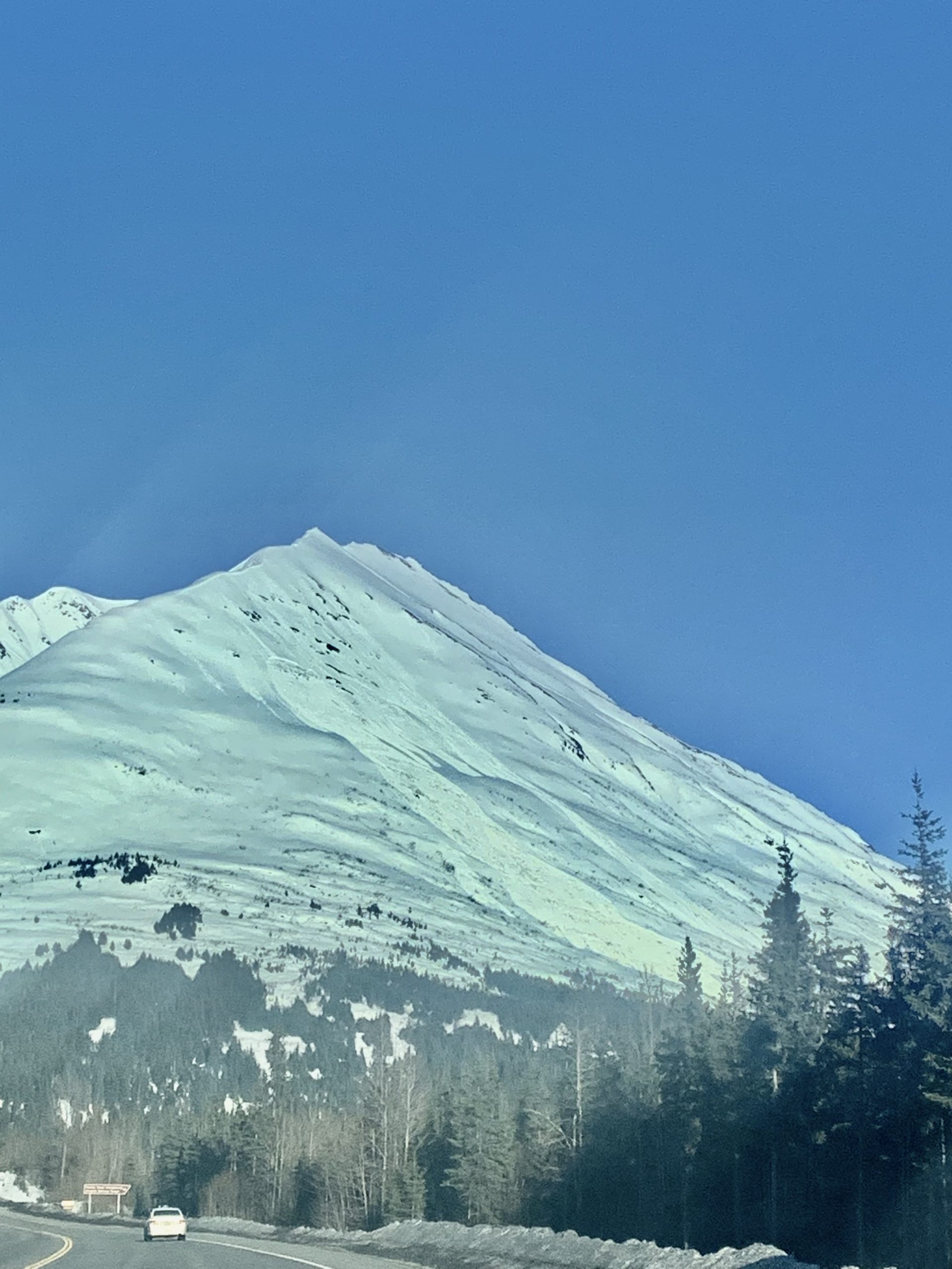
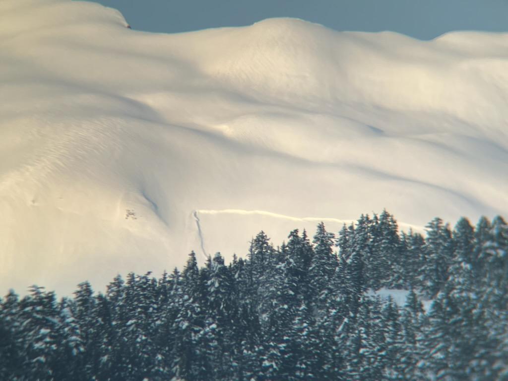
High elevation northerly aspects still holding onto dry snow but also potentially holding onto deeply buried persistent weak layers. Photo 4.21.23
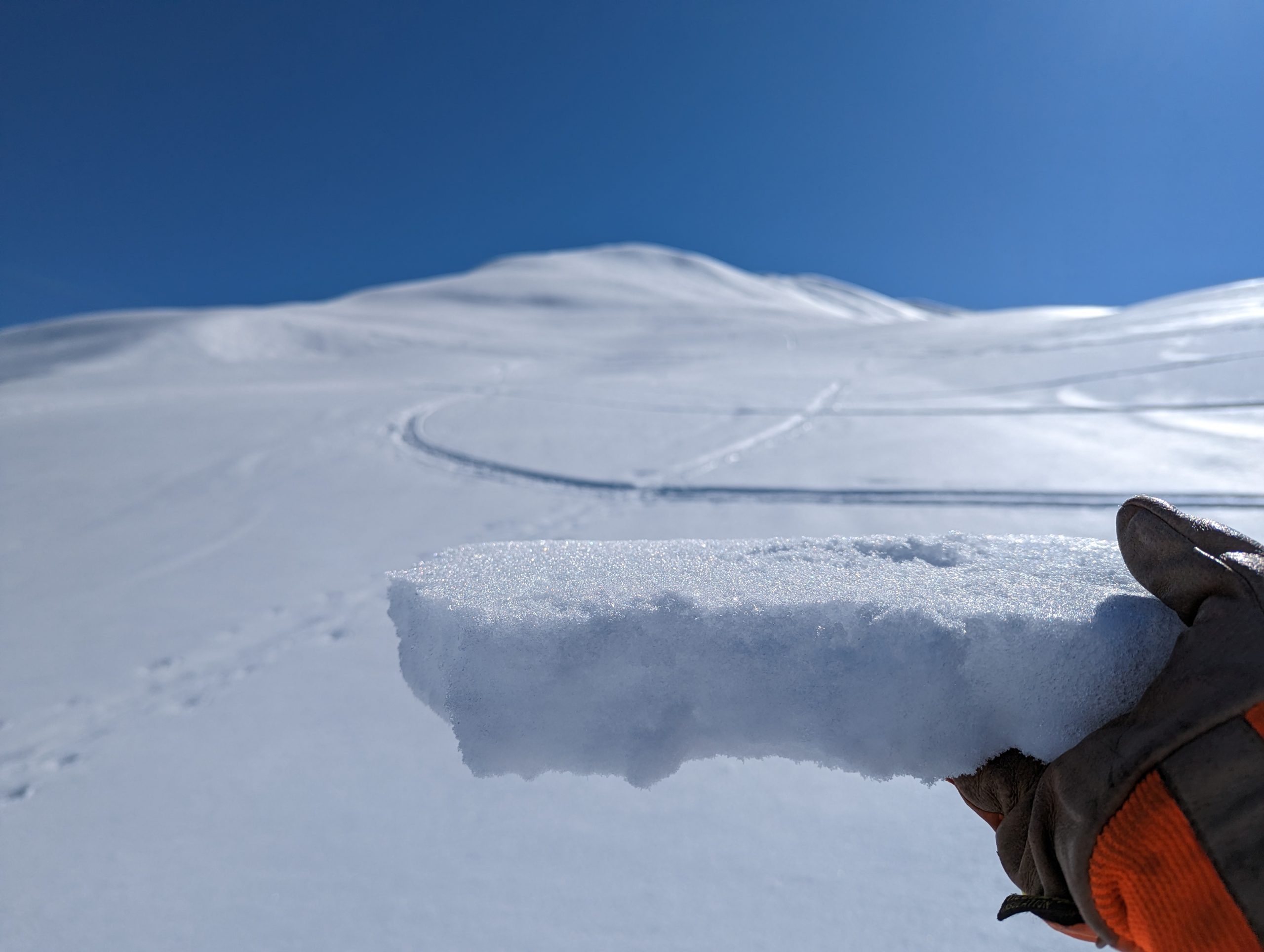
Supportable 1-2″ thick melt freeze crust on a west aspect at about 2000′ which could still potentially melt enough to cause wet loose avalanches with the warm temperatures and cloud cover today. Photo 4.21.23
Yesterday: Clear sky and really warm temperatures reaching into the 50s F at sea level and mid 30s F at upper elevations. Light winds averaging 10 mph and gusting to 20 mph at upper elevations helped to cool the snow surface in some areas.
Today: Cloud cover is expected to move into the area today, starting with high elevation clouds and then progressing toward lower elevation cloud layers in the afternoon. Winds should remain light in the 5-10 mph range out of the W this morning and switch to NW this afternoon. Temperatures are expected to cool down some today, but still reach into the mid to upper 30s F at low elevations and low 30s at upper elevations. Light rain or snowfall starts later this evening but little to no accumulation is expected.
Tomorrow: Light snow showers are possible on Sunday morning with mostly cloudy skies throughout the day. Temperatures will continue to decrease as arctic air moves over the region which should keep the snow line within a few hundred feet of sea level. Winds will shift to the east Sunday afternoon and increase slightly to 10-15 mph.
PRECIPITATION 24-hour data (6am – 6am)
Temp Avg (F) | Snow (in) | Water (in) | Snow Depth (in) | |
---|---|---|---|---|
Center Ridge (1880′) | 41 | 0 | 0 | 84 |
Summit Lake (1400′) | 36 | 0 | 0 | 41 |
Alyeska Mid (1700′) | 40 | 0 | 0 | 78 |
Bear Valley – Portage (132′) | 37 | 0 | 0 | – |
RIDGETOP 24-hour data (6am – 6am)
Temp Avg (F) | Wind Dir | Wind Avg (mph) | Wind Gust (mph) | |
---|---|---|---|---|
Sunburst (3812′) | 33 | W | 5 | 19 |
Seattle Ridge (2400′) | 39 | SW | 2 | 8 |
Date | Region | Location | Observer |
---|---|---|---|
05/22/23 | Turnagain | Avalanche: Tincan | Nick D'Alessio |
05/12/23 | Turnagain | Avalanche: Tincan, Sunburst, Magnum, Cornbiscuit | Heather Thamm |
05/07/23 | Turnagain | Observation: Tincan – Bear Tracks | CNFAIC Staff |
05/05/23 | Turnagain | Observation: Seattle Ridge | AS/ WW Forecaster |
05/02/23 | Turnagain | Observation: Cornbiscuit | Schauer/ Sturgess Forecaster |
05/02/23 | Turnagain | Observation: Seward Hwy Turnagain Pass | Joel Curtis |
04/30/23 | Turnagain | Observation: Magnum | Ayla, Kit Crosby, Barton |
04/29/23 | Turnagain | Observation: Tincan | John Sykes |
04/28/23 | Turnagain | Avalanche: Taylor Pass/Pastoral | Schauer/ Creighton Forecaster |
04/28/23 | Turnagain | Avalanche: Tincan | Andy Moderow |
Status of riding areas across the Chugach NF is managed by the Glacier and Seward Ranger Districts, not avalanche center staff. Riding area information is posted as a public service to our users and updated based on snow depth and snow density to prevent resource damage at trailhead locations. Riding area questions contact: mailroom_r10_chugach@fs.fed.us
Area | Status | Weather & Riding Conditions |
---|---|---|
Glacier District |
Subscribe to Turnagain Pass
Avalanche Forecast by Email
This is a general backcountry avalanche advisory issued for Turnagain Arm with Turnagain Pass as the core advisory area. This advisory does not apply to highways, railroads or operating ski areas.