Turnagain Pass RSS

Archives
ARCHIVED - Forecasts expire after 24 hours.
Issued
Sat, April 15th, 2023 - 7:00AM
Expires
Sun, April 16th, 2023 - 7:00AM
Forecaster
John Sykes
Avalanche risk The Bottom Line

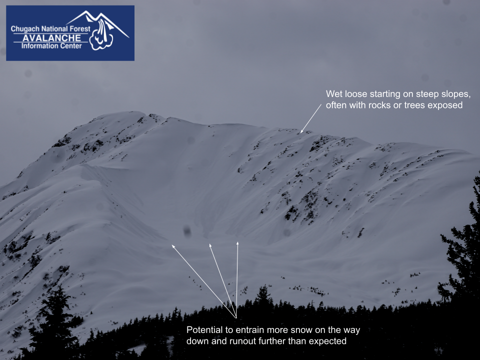
The avalanche danger is MODERATE at all elevations today. Loose wet avalanches releasing naturally as the temperatures increase throughout the day are likely. These are typically small avalanches that occur on steep slopes with wet snow on the surface, but can become large enough to bury a person on larger slopes where the initial avalanche can pick up more snow on it’s way down. Lingering wind slabs up to a foot deep at upper elevations are also possible for human triggering today.

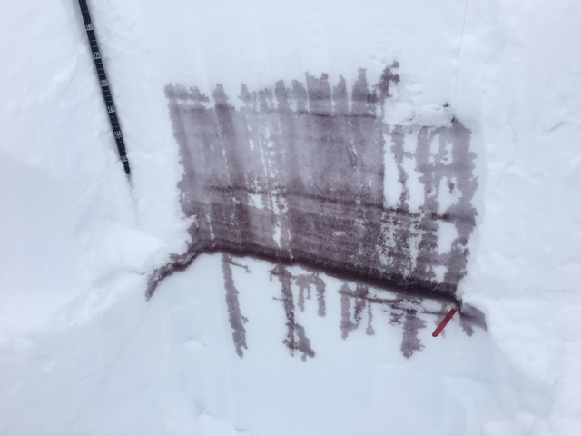
SEWARD: A layer of buried surface hoar has been reported by guiding operations near Seward. Large avalanches releasing on low angle slopes are common for buried surface hoar so extra caution is recommended along with careful snowpack evaluation and terrain selection.

Special Announcements

Avalanche Center End of Season Operations:  This is our last week of 7 day/week forecasting. Beginning April 17 we will forecast 4 days/week (Tuesday, Thursday, Saturday, Sunday). The final forecast is scheduled for April 30th.

We’re looking for your input! We’ve put together a quick survey about the avalanche forecast that should take 5-10 minutes. If you haven’t yet, please Click here. Big thanks to everyone who has responded!

Sat, April 15th, 2023
Alpine
Above 2,500'
2 - Moderate
Avalanche risk
Treeline
1,000'-2,500'
2 - Moderate
Avalanche risk
Below Treeline
Below 1,000'
2 - Moderate
Avalanche risk
0 - No Rating
1 - Low
2 - Moderate
3 - Considerable
4 - High
5 - Extreme
Avalanche risk Avalanche risk Avalanche risk Avalanche risk Avalanche risk
Travel Advice Generally safe avalanche conditions. Watch for unstable snow on isolated terrain features. Heightened avalanche conditions on specific terrain features. Evaluate snow and terrain carefully; identify features of concern. Dangerous avalanche conditions. Careful snowpack evaluation, cautious route-finding, and conservative decision-making essential. Very dangerous avalanche conditions. Travel in avalanche terrain not recommended. Extraordinarily dangerous avalanche conditions. Avoid all avalanche terrain.
Likelihood of Avalanches Natural and human-triggered avalanches unlikely. Natural avalanches unlikely; human-triggered avalanches possible. Natural avalanches possible; human-triggered avalanches likely. Natural avalanches likely; human-triggered avalanches very likely. Natural and human-triggered avalanches certain.
Avalanche Size and Distribution Small avalanches in isolated areas or extreme terrain. Small avalanches in specific areas; or large avalanches in isolated areas. Small avalanches in many areas; or large avalanches in specific areas; or very large avalanches in isolated areas. Large avalanches in many areas; or very large avalanches in specific areas. Very large avalanches in many areas.
Recent Avalanches

No recent avalanches were observed yesterday due to very poor visibility. The last known cycle of avalanche activity was during and after the Easter storm when storm slabs and loose snow avalanches were occurring because the new snow did not bond well with the icy old snow surface.

Avalanche Problem 1
  • Wet Loose
    Wet Loose
  • Aspect/Elevation
  • Certain
    Very Likely
    Likely
    Possible
    Unlikely
    Likelihood
  • Historic (D4-5)
    Very Large (D3)
    Large (D2)
    Small (D1)
    Size
Wet Loose
Wet Loose avalanches are the release of wet unconsolidated snow or slush. These avalanches typically occur within layers of wet snow near the surface of the snowpack, but they may quickly gouge into lower snowpack layers. Like Loose Dry Avalanches, they start at a point and entrain snow as they move downhill, forming a fan-shaped avalanche. Other names for loose-wet avalanches include point-release avalanches or sluffs. Loose Wet avalanches can trigger slab avalanches that break into deeper snow layers.

Aspect/Elevation of the Avalanche Problem
Specialists develop a graphic representation of the potential distribution of a particular avalanche problem across the topography. This aspect/elevation rose is used to indicate where the particular avalanche problem is thought to exist on all elevation aspects. Areas where the avalanche problem is thought to exist are colored grey, and it is less likely to be encountered in areas colored white.

Likelihood of Avalanches
Terms such as "unlikely", "likely", and "certain" are used to define the scale, with the chance of triggering or observing avalanches increasing as we move up the scale. For our purposes, "Unlikely" means that few avalanches could be triggered in avalanche terrain and natural avalanches are not expected. "Certain" means that humans will be able to trigger avalanches on many slopes, and natural avalanches are expected.

Size of Avalanches
Avalanche size is defined by the largest potential avalanche, or expected range of sizes related to the problem in question. Assigned size is a qualitative estimate based on the destructive classification system and requires specialists to estimate the harm avalanches may cause to hypothetical objects located in the avalanche track (AAA 2016, CAA 2014). Under this schema, "Small" avalanches are not large enough to bury humans and are relatively harmless unless they carry people over cliffs or through trees or rocks. Moving up the scale, avalanches become "Large" enough to bury, injure, or kill people. "Very Large" avalanches may bury or destroy vehicles or houses, and "Historic" avalanches are massive events capable of altering the landscape.

Signal Word Size (D scale) Simple Descriptor
Small 1 Unlikely to bury a person
Large 2 Can bury a person
Very Large 3 Can destroy a house
Historic 4 & 5 Can destroy part or all of a village
More info at Avalanche.org

Temperatures are expected to increase today, reaching close to freezing at upper elevations, which will cause the new snow from yesterday to start shedding off of steeper slopes later in the day. Loose wet avalanches are typically small, but on larger steep slopes they can entrain a lot of loose snow on their way down and produce enough debris to potentially bury a person. We saw lots of avalanche activity like this after the Easter storm and expect very similar conditions today. This type of avalanche activity typically starts in the early afternoon and can increase in size into the evening as more of the surface snow melts and becomes weak enough to slide off the mountainside.

These conditions develop throughout the day as the snow surface gradually melts. You can monitor conditions by paying attention to how deeply your skis or snowmachine are sinking into the surface snow and looking for roller balls or smaller wet loose avalanches. If your boots are sinking into wet snow over ankle deep that is a sign that larger wet loose avalanches are likely. Moving to higher elevations or a shadier aspect where the surface snow is less melted is recommended to avoid this hazard, but temperatures are going to be warm enough today that we expect loose wet avalanches on all aspects.

Lingering wind slabs around 1′ deep that formed yesterday could also be an issue along upper elevation ridgelines. To identify wind slabs look for areas with hollow feeling wind transported snow on the surface and use small test slopes to check for shooting cracks. In addition, cornices and glide cracks are more likely to fail during period of warmer temperatures especially if cornices are getting direct sunlight. This is the time of year when these behemoths start to naturally release and you definitely want to avoid being underneath when a big chunk falls off!

Examples of long running wet loose avalanches in Todd’s bowl on the N aspect of Tincan. Photo 4.13.23

Additional Concern
  • Deep Persistent Slabs
    Deep Persistent Slabs
Deep Persistent Slabs
Deep Persistent Slab avalanches are the release of a thick cohesive layer of hard snow (a slab), when the bond breaks between the slab and an underlying persistent weak layer deep in the snowpack. The most common persistent weak layers involved in deep, persistent slabs are depth hoar or facets surrounding a deeply buried crust. Deep Persistent Slabs are typically hard to trigger, are very destructive and dangerous due to the large mass of snow involved, and can persist for months once developed. They are often triggered from areas where the snow is shallow and weak, and are particularly difficult to forecast for and manage.
More info at Avalanche.org

A weak layer of facets buried about 3-6′ deep in the snowpack is still on our radar due to widespread very large avalanche activity on this layer in the second half of March. It has been two weeks since we have seen any avalanche activity on this layer and we think it is very unlikely for a human triggered or natural avalanche. However, due to the consequences of being involved with an avalanche this size we are still keeping track of it.

As the temperatures increase and more free water exists in the snowpack we expect that this weak layer could become active again and produce large wet slab avalanches.  The image below shows how melt water is percolating through the snowpack, with darker colors indicate melt water pooling in that layer. The 3.14 facet layer is indicated with a red popsicle stick and we can see a lot of melt water pooling in that layer, which is an early indication that this layer could be problematic as more melt water moves through the snowpack over the coming days or weeks.

Results of a percolation test from Tincan yesterday, with an alarming amount of the melt water pooling in the 3.14 facet layer. Photo Nancy Pfeiffer 4.14.23

Overview of general snowpack structure. The depth to the weak layer varies a lot across the forecast area from 3-6’+ deep. Photo 4.13.23

Weather
Sat, April 15th, 2023

Yesterday: Cloudy skies with light snow throughout the day resulting in about 4″ of new snow at the road level in Turnagain Pass. Snow totals were likely higher in Portage/Placer area, with the Bear Valley weather station showing almost 0.6″ of water which would roughly equate to 6-8″ or more of snow at upper elevations. Winds at upper elevations were E at 10-15 mph with gusts to 30 mph. Temperatures stayed in the low to mid 20s F above treeline and crept up into the mid 30s F below treeline.

Today: No more new snow is expected today, but a layer of high clouds should stick around throughout the day creating mostly cloudy conditions. Winds backed off early this morning and should remain light throughout the day out of the E at 5-15 mph. Temperatures are expected to climb higher today reaching the low 30s at upper elevations and 40s at lower elevations.

Tomorrow: Sunday is expected to be very similar to Saturday, but with a higher chance of some snow showers throughout the day. No significant accumulation of new snow is expected. Winds should remain light out of the E in the 5-15 mph range.

PRECIPITATION 24-hour data (6am – 6am)

Temp Avg (F) Snow (in) Water (in) Snow Depth (in)
Center Ridge (1880′) 32 4 0.2 92
Summit Lake (1400′) 33 3 0.2 44
Alyeska Mid (1700′) 31 4 0.24 90
Bear Valley – Portage (132′) 35 0 0.6

RIDGETOP 24-hour data (6am – 6am)

Temp Avg (F) Wind Dir Wind Avg (mph) Wind Gust (mph)
Sunburst (3812′) 21 ENE 10 27
Seattle Ridge (2400′) 26 ESE 6 17
Observations
Recent Observations for Turnagain Pass
Date Region Location
04/23/24 Turnagain Observation: Turnagain Sunny Side
04/21/24 Turnagain Observation: Bertha Creek
04/20/24 Turnagain Avalanche: Spokane Creek
04/16/24 Turnagain Observation: Cornbiscuit
04/15/24 Turnagain Observation: Taylor Pass
04/15/24 Turnagain Observation: Seward Highway – Tern Lake to Portage
04/14/24 Turnagain Observation: Sunburst
04/14/24 Turnagain Observation: Turnagain Pass Snomo
04/13/24 Turnagain Observation: Spokane Creek
04/11/24 Turnagain Observation: Tincan
Riding Areas

The riding areas page has moved. Please click here & update your bookmarks.


Subscribe to Turnagain Pass
Avalanche Forecast by Email

This is a general backcountry avalanche advisory issued for Turnagain Arm with Turnagain Pass as the core advisory area. This advisory does not apply to highways, railroads or operating ski areas.