Turnagain Pass RSS

Archives
ARCHIVED - Forecasts expire after 24 hours.
Issued
Thu, April 6th, 2023 - 7:00AM
Expires
Fri, April 7th, 2023 - 7:00AM
Forecaster
John Sykes
Avalanche risk The Bottom Line

The avalanche danger remains MODERATE above 1000′. Loose wet avalanches could release naturally or be easily human triggered if the sun is able to break through the clouds today and melt the surface crust that exists on solar aspects. In addition we are still concerned about the potential for very large avalanches releasing on a buried weak layer 3-6′ deep. Human triggered avalanches are unlikely on this layer, but the consequences are high so we are continuing to recommend conservative terrain selection.

Below 1000′ the avalanche danger is LOW. Springtime melt freeze conditions exist at lower elevations and loose wet avalanches are likely in the afternoon.

Thu, April 6th, 2023
Alpine
Above 2,500'
2 - Moderate
Avalanche risk
Treeline
1,000'-2,500'
2 - Moderate
Avalanche risk
Below Treeline
Below 1,000'
1 - Low
Avalanche risk
0 - No Rating
1 - Low
2 - Moderate
3 - Considerable
4 - High
5 - Extreme
Avalanche risk Avalanche risk Avalanche risk Avalanche risk Avalanche risk
Travel Advice Generally safe avalanche conditions. Watch for unstable snow on isolated terrain features. Heightened avalanche conditions on specific terrain features. Evaluate snow and terrain carefully; identify features of concern. Dangerous avalanche conditions. Careful snowpack evaluation, cautious route-finding, and conservative decision-making essential. Very dangerous avalanche conditions. Travel in avalanche terrain not recommended. Extraordinarily dangerous avalanche conditions. Avoid all avalanche terrain.
Likelihood of Avalanches Natural and human-triggered avalanches unlikely. Natural avalanches unlikely; human-triggered avalanches possible. Natural avalanches possible; human-triggered avalanches likely. Natural avalanches likely; human-triggered avalanches very likely. Natural and human-triggered avalanches certain.
Avalanche Size and Distribution Small avalanches in isolated areas or extreme terrain. Small avalanches in specific areas; or large avalanches in isolated areas. Small avalanches in many areas; or large avalanches in specific areas; or very large avalanches in isolated areas. Large avalanches in many areas; or very large avalanches in specific areas. Very large avalanches in many areas.
Recent Avalanches

No new avalanches have been observed in the past several days. Over the past two weeks there have been 18 very large human triggered avalanches on a deeply buried layer of facets. We have not seen any activity on that layer since 9 days ago, when the 6th skier on a slope triggered an avalanche in Winner creek in Girdwood.

Avalanche Problem 1
  • Wet Loose
    Wet Loose
  • Aspect/Elevation
  • Certain
    Very Likely
    Likely
    Possible
    Unlikely
    Likelihood
  • Historic (D4-5)
    Very Large (D3)
    Large (D2)
    Small (D1)
    Size
Wet Loose
Wet Loose avalanches are the release of wet unconsolidated snow or slush. These avalanches typically occur within layers of wet snow near the surface of the snowpack, but they may quickly gouge into lower snowpack layers. Like Loose Dry Avalanches, they start at a point and entrain snow as they move downhill, forming a fan-shaped avalanche. Other names for loose-wet avalanches include point-release avalanches or sluffs. Loose Wet avalanches can trigger slab avalanches that break into deeper snow layers.

Aspect/Elevation of the Avalanche Problem
Specialists develop a graphic representation of the potential distribution of a particular avalanche problem across the topography. This aspect/elevation rose is used to indicate where the particular avalanche problem is thought to exist on all elevation aspects. Areas where the avalanche problem is thought to exist are colored grey, and it is less likely to be encountered in areas colored white.

Likelihood of Avalanches
Terms such as "unlikely", "likely", and "certain" are used to define the scale, with the chance of triggering or observing avalanches increasing as we move up the scale. For our purposes, "Unlikely" means that few avalanches could be triggered in avalanche terrain and natural avalanches are not expected. "Certain" means that humans will be able to trigger avalanches on many slopes, and natural avalanches are expected.

Size of Avalanches
Avalanche size is defined by the largest potential avalanche, or expected range of sizes related to the problem in question. Assigned size is a qualitative estimate based on the destructive classification system and requires specialists to estimate the harm avalanches may cause to hypothetical objects located in the avalanche track (AAA 2016, CAA 2014). Under this schema, "Small" avalanches are not large enough to bury humans and are relatively harmless unless they carry people over cliffs or through trees or rocks. Moving up the scale, avalanches become "Large" enough to bury, injure, or kill people. "Very Large" avalanches may bury or destroy vehicles or houses, and "Historic" avalanches are massive events capable of altering the landscape.

Signal Word Size (D scale) Simple Descriptor
Small 1 Unlikely to bury a person
Large 2 Can bury a person
Very Large 3 Can destroy a house
Historic 4 & 5 Can destroy part or all of a village
More info at Avalanche.org

The sun mostly stayed masked behind a layer of low elevation clouds yesterday in Turnagain Pass, which kept the snow surface crusty on solar aspects at upper elevations. Today thin low elevation cloud cover is expected to linger throughout the morning before giving way to clear skies this evening. On slopes that are receiving direct sunlight today it is possible that the 1-2″ thick surface crust will melt and wet loose avalanches will be easy for people to trigger. Loose snow avalanches are fairly predictable since they occur on the surface, but it can be surprising how much momentum they pick up on the way down a slope. This is especially true on longer slopes where wet loose avalanches can grow to be big enough to bury a person. Keep an eye out for softening and sticky surface conditions on east, south, and west aspects and be aware of the potential for loose wet avalanches to release naturally from steep rocky terrain.

Cornices are also more likely to fail spontaneously under direct sunlight and can drop large chunks of snow on the slope below. Try to avoid spending much time directly underneath cornices that are being heated up by the sun and look for signs of wet loose avalanche conditions as an indicator that cornices on similar aspects are prone to failure.

So far it has been a fairly cool and cloudy transition to spring and the snowpack is still holding on, but sooner of later we will start to see glide avalanches releasing to the ground. There are several glide cracks primed to release on the N end of Turnagain pass near Wolverine and along Seattle Ridge. It is strongly recommended to avoid spending time underneath glide cracks, especially during the heat of the day when the added melt could make them more likely to release.

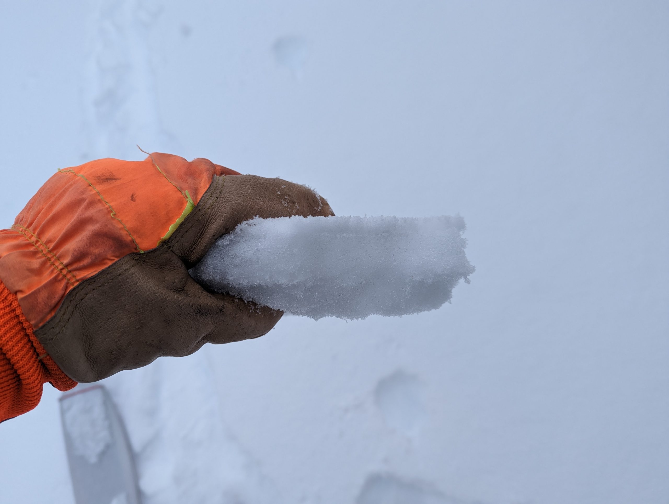
Fairly stout 1-2″ thick melt freeze crust at lower elevations on all aspects and at upper elevations on solar aspects. Photo 4.5.23 

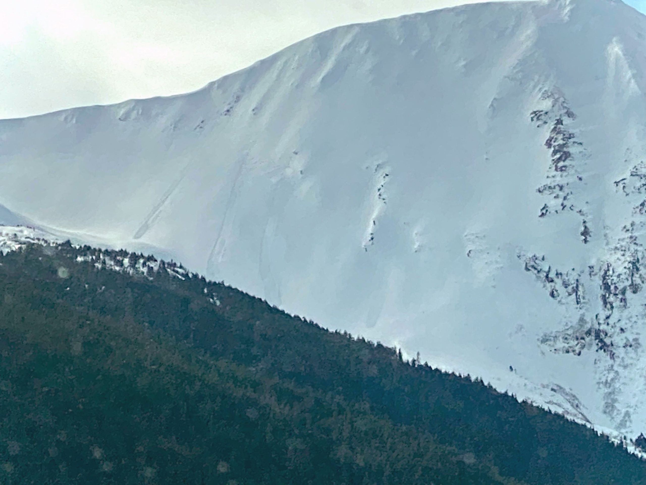
Wet loose avalanches on the SE face of Pyramid. Photo 4.5.23

Avalanche Problem 2
  • Deep Persistent Slabs
    Deep Persistent Slabs
  • Aspect/Elevation
  • Certain
    Very Likely
    Likely
    Possible
    Unlikely
    Likelihood
  • Historic (D4-5)
    Very Large (D3)
    Large (D2)
    Small (D1)
    Size
Deep Persistent Slabs
Deep Persistent Slab avalanches are the release of a thick cohesive layer of hard snow (a slab), when the bond breaks between the slab and an underlying persistent weak layer deep in the snowpack. The most common persistent weak layers involved in deep, persistent slabs are depth hoar or facets surrounding a deeply buried crust. Deep Persistent Slabs are typically hard to trigger, are very destructive and dangerous due to the large mass of snow involved, and can persist for months once developed. They are often triggered from areas where the snow is shallow and weak, and are particularly difficult to forecast for and manage.

Aspect/Elevation of the Avalanche Problem
Specialists develop a graphic representation of the potential distribution of a particular avalanche problem across the topography. This aspect/elevation rose is used to indicate where the particular avalanche problem is thought to exist on all elevation aspects. Areas where the avalanche problem is thought to exist are colored grey, and it is less likely to be encountered in areas colored white.

Likelihood of Avalanches
Terms such as "unlikely", "likely", and "certain" are used to define the scale, with the chance of triggering or observing avalanches increasing as we move up the scale. For our purposes, "Unlikely" means that few avalanches could be triggered in avalanche terrain and natural avalanches are not expected. "Certain" means that humans will be able to trigger avalanches on many slopes, and natural avalanches are expected.

Size of Avalanches
Avalanche size is defined by the largest potential avalanche, or expected range of sizes related to the problem in question. Assigned size is a qualitative estimate based on the destructive classification system and requires specialists to estimate the harm avalanches may cause to hypothetical objects located in the avalanche track (AAA 2016, CAA 2014). Under this schema, "Small" avalanches are not large enough to bury humans and are relatively harmless unless they carry people over cliffs or through trees or rocks. Moving up the scale, avalanches become "Large" enough to bury, injure, or kill people. "Very Large" avalanches may bury or destroy vehicles or houses, and "Historic" avalanches are massive events capable of altering the landscape.

Signal Word Size (D scale) Simple Descriptor
Small 1 Unlikely to bury a person
Large 2 Can bury a person
Very Large 3 Can destroy a house
Historic 4 & 5 Can destroy part or all of a village
More info at Avalanche.org

We are still concerned about the potential for very large human triggered avalanches releasing on a layer of facets buried 3-6′ deep. It has been two weeks since the last significant snowfall in our forecast area which has given the snowpack some time to gain strength. Over the past few days we have seen improving snowpack structure in a few locations in Turnagain Pass (Seattle Ridge, Pete’s N) which is an encouraging sign. However, deep persistent weak layers can linger for weeks to months and the consequences of triggering a very large avalanche are driving us to continue travelling in lower angle terrain and being aware of overhead hazards that could be triggered remotely. We are now in the ‘SCARY MODERATE’ phase of this avalanche problem, where the likelihood of triggering an avalanche is low but the consequences remain high.

Snowpack on a SW aspect at the top of treeline on Pete’s N, still concerning structure but the weak layer seems to be gaining some strength. Photo 4.5.23


Weather
Thu, April 6th, 2023

Yesterday: Broken to partly sunny skies with light winds. Temperatures reached 40 F near sea level and stayed in the mid 20s F at upper elevations. No new snowfall.

Today: Conditions should be very similar to yesterday. Low clouds lingering in the area will bring partly sunny skies in the morning which should trend towards clearing in the evening. Winds are expected to remain light at 5-10 mph. Temperatures should climb back above freezing at lower elevations today and remain in the mid 20s at upper elevations.

Tomorrow: Cloud cover will start to build overnight and increase throughout the day tomorrow. Snow showers should start during the day tomorrow but with minimal snow accumulation expected. Winds are expected to remain light at 5-15 mph but shift to the SE Friday morning. Winds will pick up more overnight on Friday with wind speed up to 30 mph possible.

PRECIPITATION 24-hour data (6am – 6am)

Temp Avg (F) Snow (in) Water (in) Snow Depth (in)
Center Ridge (1880′) 30 0 0 90
Summit Lake (1400′) 30 0 0 45
Alyeska Mid (1700′) 29 0 0 83
Bear Valley – Portage (132′) 33 0 0

RIDGETOP 24-hour data (6am – 6am)

Temp Avg (F) Wind Dir Wind Avg (mph) Wind Gust (mph)
Sunburst (3812′) 20 NW 3 11
Seattle Ridge (2400′) 24 NNW 3 10
Observations
Recent Observations for Turnagain Pass
Date Region Location
04/23/24 Turnagain Observation: Turnagain Sunny Side
04/21/24 Turnagain Observation: Bertha Creek
04/20/24 Turnagain Avalanche: Spokane Creek
04/16/24 Turnagain Observation: Cornbiscuit
04/15/24 Turnagain Observation: Taylor Pass
04/15/24 Turnagain Observation: Seward Highway – Tern Lake to Portage
04/14/24 Turnagain Observation: Sunburst
04/14/24 Turnagain Observation: Turnagain Pass Snomo
04/13/24 Turnagain Observation: Spokane Creek
04/11/24 Turnagain Observation: Tincan
Riding Areas

The riding areas page has moved. Please click here & update your bookmarks.


Subscribe to Turnagain Pass
Avalanche Forecast by Email

This is a general backcountry avalanche advisory issued for Turnagain Arm with Turnagain Pass as the core advisory area. This advisory does not apply to highways, railroads or operating ski areas.