Turnagain Pass Avalanche Forecast
|
![]() ![]() |
Warm temperatures and direct sunlight will increase the avalanche danger from LOW this morning to MODERATE by this afternoon/evening. Human triggered wet loose avalanches on steep, solar aspects, especially above 3000′, are possible once the sun softens surface crusts and weakens the snowpack. Avoid being under glide cracks and give cornices an extra wide berth!
PORTAGE VALLEY: Summer trails with avalanche terrain overhead, such as Byron Glacier Trail and Crow Pass, are still not recommended in the afternoon or evening due to the possibility of an avalanche occurring above.
SUMMIT LAKE (& INTERIOR EASTERN KENAI MTS): Human triggered slab avalanches remain possible in upper elevation terrain on all aspects. This area has a thin snowpack with many weak layers. High elevation sun-affected slopes are the most suspect for triggering a slab.
SEWARD/LOST LAKE: Similar to the Turnagain Area travel on solar aspects should be carefully evaluated later in the day and travel under glide cracks should be avoided.
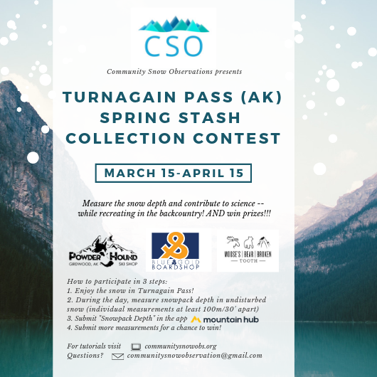
Help track snow depth and WIN PRIZES too! The Turnagain Pass Spring Stash Collection Contest ends April 15th and the community needs your help!
Signal Word | Size (D scale) | Simple Descriptor |
Small | 1 | Unlikely to bury a person |
Large | 2 | Can bury a person |
Very Large | 3 | Can destroy a house |
Historic | 4 & 5 | Can destroy part or all of a village |
Yesterday was slightly cooler than the day before and overnight temperatures were cooler than the past couple nights. Clear skies promoted a solid freeze overnight. The snowpack has already seen many days of a springtime melt-freeze pattern in the low and mid-elevations. Overall the possibility of natural wet loose and wet slab avalanches has decreased. However, there is still the potential for person, on skis or a machine, to trigger an avalanche in the afternoon/evening on solar aspects as the crust breaks down and slopes get soft and punchy. This is heightened in the Alpine where the warming of the surface snow is more recent.
A safe day in the mountains includes planning ahead. Know the terrain you are traveling on and under and if it will be affected by the sun. The avalanche danger on steep slopes on the southern end of the compass will increase this afternoon/evening. Play the aspects for the best conditions and to stay safe. The boot test is a great way to assess how the daytime warming is, or is not, affecting the surface. If your boot easily sinks into mushy wet snow, it’s time to get onto shaded slopes or off the one you are on. Wet loose avalanches can start small from a person pushing soft wet snow as they ski or ride. If the terrain is large enough, this small slide can entrain snow and turn into a large and unmanageable avalanche.
CORNICES: Cornices are very large and direct sunshine will destabilize them. A cornice fall still has the potential to trigger an avalanche on the slope below and could break farther back than expected.
Snowmachine triggered wet loose avalanche on to the uptrack on Friday, 3-29-19. Photo: Sean Fallon
Cornice over Warm up bowl, 3-30-19. Photo: Graham Predeger. Give cornices a wide berth.
Signal Word | Size (D scale) | Simple Descriptor |
Small | 1 | Unlikely to bury a person |
Large | 2 | Can bury a person |
Very Large | 3 | Can destroy a house |
Historic | 4 & 5 | Can destroy part or all of a village |
Glide cracks are appearing throughout the advisory area and have been avalanching daily. Yesterday was the first day without notable activity reported but the message remains the same. Avoid traveling under glide cracks at all times of the day! Remember, glides can release even if a hard surface crust is present (unlike the wet loose and wet slab avalanche problems). Many cracks are opening up in popular terrain and keep an eye out for them. Glide avalanches are full depth avalanches that have the potential to very dangerous.
Glide avalanche South side of Wolverine, observed 3-30-19.
Glide avalanche Lynx creek, witnessed in motion on 3-29-19.
Yesterday: Sunshine and clear skies with temperatures in the high 30Fs to mid 40Fs. Winds were light and westerly. Overnight temperatures dipped into the 20Fs and mid to low 30Fs. Skies were clear and winds increased slightly overnight gusting into the teens.
Today: More sunshine and clear skies with temperatures in the 30Fs in the Alpine and 40Fs at lower elevations. Winds will be westerly 5-10 with gusts into the teens. Overnight skies will be partly cloudy and temperatures are forecast to decrease into Wednesday as cooler air moves over the region.
Tomorrow: Clear and sunny again with cooler temperatures and light winds. There is still some uncertainty about the precipitation potential on Thursday and Friday but expect clouds and a chance of rain/snow showers.
Temp Avg (F) | Snow (in) | Water (in) | Snow Depth (in) | |
Center Ridge (1880′) | 39 | 0 | 0 | 66 |
Summit Lake (1400′) | 34 | 0 | 0 | 22 |
Alyeska Mid (1700′) | 40 | 0 | 0 | 59 |
Temp Avg (F) | Wind Dir | Wind Avg (mph) | Wind Gust (mph) | |
Sunburst (3812′) | 32 | W | 3 | 13 |
Seattle Ridge (2400′) | 37 | W | 1 | 4 |
Date | Region | Location | Observer |
---|---|---|---|
01/31/23 | Turnagain | Observation: Johnson Pass area | Megan Guinn / W Wagner Forecaster |
01/29/23 | Turnagain | Observation: Tincan Backdoor | AAS-Level 1 1/27-1/30 |
01/28/23 | Turnagain | Observation: Sunburst | Brooke Edwards |
01/28/23 | Turnagain | Avalanche: Seattle Ridge | W Wagner |
01/28/23 | Turnagain | Observation: Tincan Common | Tony Naciuk |
01/27/23 | Turnagain | Observation: Sunburst | John Sykes |
01/27/23 | Turnagain | Avalanche: Lynx Creek | Megan Guinn / W Wagner |
01/25/23 | Turnagain | Observation: Cornbiscuit | John Sykes Forecaster |
01/22/23 | Turnagain | Avalanche: Tincan | Schauer/ Guinn |
01/21/23 | Turnagain | Avalanche: Seattle Ridge | Elias Holt |
Status of riding areas across the Chugach NF is managed by the Glacier and Seward Ranger Districts, not avalanche center staff. Riding area information is posted as a public service to our users and updated based on snow depth and snow density to prevent resource damage at trailhead locations. Riding area questions contact: mailroom_r10_chugach@fs.fed.us
Area | Status | Weather & Riding Conditions |
---|---|---|
Glacier District |
Subscribe to Turnagain Pass
Avalanche Forecast by Email
This is a general backcountry avalanche advisory issued for Turnagain Arm with Turnagain Pass as the core advisory area. This advisory does not apply to highways, railroads or operating ski areas.