Turnagain Pass
|
|
The avalanche danger is CONSIDERABLE at all elevations where heavy precipitation is falling. This is in Portage and Placer Valleys and possibly in Girdwood. Turnagain Pass should see less precipitation and expected to remain at MODERATE danger. In general, a variety of avalanche concerns exist as warm, wet, and windy weather remains over the region. Fresh wind slab avalanches could be found and triggered above 2,000′ on steep slopes and gullies. There is still a chance a larger slab could be triggered due to old buried weak layers 2 to 3 feet deep. Below around 2,000′ wet snow avalanches are an issue due to rain and warm temperatures.
PORTAGE/PLACER/SEWARD: These areas may see another inch or more of rain below 1,500′ and up to a another foot of new snow above 1,500′ by tonight. If the forecast verifies, natural avalanche potential will increase creating dangerous avalanche conditions.
Roof Avalanches: Heads up – roofs are continuing to shed their snow with this warm weather.
| Tue, March 26th, 2024 |
| |
|
|
|
|
|
| Travel Advice | Generally safe avalanche conditions. Watch for unstable snow on isolated terrain features. | Heightened avalanche conditions on specific terrain features. Evaluate snow and terrain carefully; identify features of concern. | Dangerous avalanche conditions. Careful snowpack evaluation, cautious route-finding, and conservative decision-making essential. | Very dangerous avalanche conditions. Travel in avalanche terrain not recommended. | Extraordinarily dangerous avalanche conditions. Avoid all avalanche terrain. |
| Likelihood of Avalanches | Natural and human-triggered avalanches unlikely. | Natural avalanches unlikely; human-triggered avalanches possible. | Natural avalanches possible; human-triggered avalanches likely. | Natural avalanches likely; human-triggered avalanches very likely. | Natural and human-triggered avalanches certain. |
| Avalanche Size and Distribution | Small avalanches in isolated areas or extreme terrain. | Small avalanches in specific areas; or large avalanches in isolated areas. | Small avalanches in many areas; or large avalanches in specific areas; or very large avalanches in isolated areas. | Large avalanches in many areas; or very large avalanches in specific areas. | Very large avalanches in many areas. |
There were no new avalanches reported yesterday. With cloudy skies and poor visibility it’s tough to get a good look at what is happening on the slopes during this warm stormy weather. Even those debris piles seen from the road can look fresh if they get some rain on them. Hence, there is uncertainty as to what has been happening out in the backcountry in general for the past couple days. The last known avalanches were two glide releases in the Summit Lake area on Friday, and one small glide avalanche on south facing Eddie’s Ridge on Thursday.
| Signal Word | Size (D scale) | Simple Descriptor |
| Small | 1 | Unlikely to bury a person |
| Large | 2 | Can bury a person |
| Very Large | 3 | Can destroy a house |
| Historic | 4 & 5 | Can destroy part or all of a village |
The warm, wet, and windy weather is over Girdwood, Portage, Turnagain Pass, and the Kenai Peninsula for what looks to be another couple days. Yesterday, Portage Valley saw just over an inch of rain but only a few tenths was seen elsewhere. The rain/snow line has been hovering around 1,500′ in general. More, and possibly heavier, precipitation is expected today. The rain/snow line should be between 1,000 and 1,500′. Up to 4″ of new snow could be seen above 1,500′ in most areas with closer to a foot at the higher elevations in Portage, Placer, and Seward.
Wind Slabs and Cornices – Above 2,000′: The ridgetop winds have been strong from the east for almost 2 days now; averaging in the 20s mph and gusting in the 50s at times. We can assume wind slabs are forming with the few inches of new snow that is falling. How much of the older crusty snow the winds are able to pick up and move into wind slabs is a question; probably not a whole lot. If you do head out today into the higher elevations, watch for wind slabs near ridgelines, steep gullies, and convex rolls. As always, pay close attention to red flags like shooting cracks or collapsing in the snowpack along with looking for stiff snow over softer snow.
Wet Avalanches – Below 2,000′: At elevations below 2,000′ we think there has been some degree of wet snow avalanching occurring, nothing very big that we know of yet. With continued rain today, more natural wet snow avalanches are possible. If you end up on a slope with wet saturated snow, be mindful you could trigger a wet snow avalanche. These can be large and dangerous if they are on big steep slopes where they can gain momentum and entrain more wet snow as they move down hill.
South facing slopes of Peak 4940. This is looking north from just west of the Johnson Pass trailhead. Many wet snow avalanches have been filling in the gullies over the past week. Thanks to Joel Curtis for the picture, 3.24.2024.
Turnagain Pass yesterday afternoon. A bit soggy but the sun should come out later this week! Photo from the RWIS webcam that is now back online, 3.24.2024.
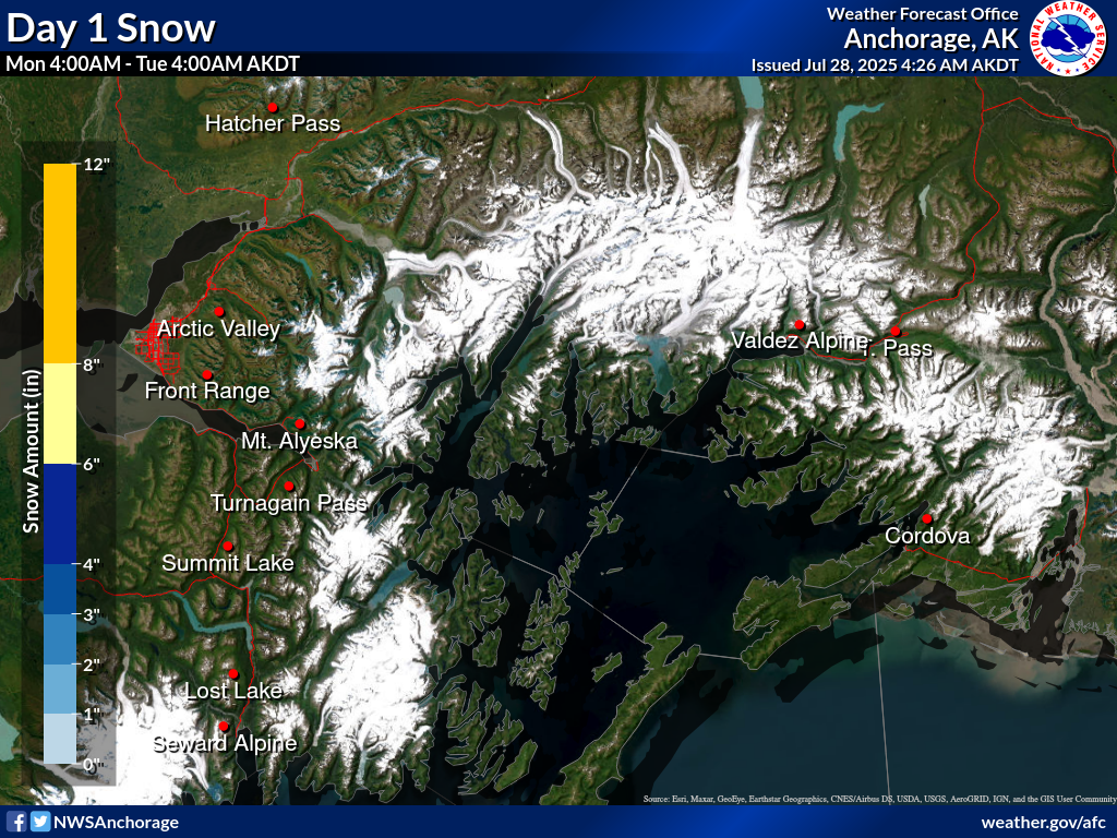
Precipitation for today (Monday) into tomorrow. Seward area as well as Portage is clearly the expected winner, yet rain line in these areas should be higher, closer to 2,000′ compared to 1,500′ inland. Thanks to the NWS for the graphics found HERE.
| Signal Word | Size (D scale) | Simple Descriptor |
| Small | 1 | Unlikely to bury a person |
| Large | 2 | Can bury a person |
| Very Large | 3 | Can destroy a house |
| Historic | 4 & 5 | Can destroy part or all of a village |
We are still concerned with a weak layer of facets and surface hoar that was buried two weeks ago. The warm stormy weather and our event on Saturday has kept us out of the mountains for a couple days, yet we still think there is a chance a person could trigger a 2-3 foot deep slab. These persistent weak layers are tricky to assess, since they can sometimes cause avalanches even when you don’t see any of the classic warning signs like cracking or collapsing. Unfortunately, from what we have been seeing, it seems like this weak interface is most concerning right in the middle of our advisory area on Turnagain Pass. Keeping this layer in mind we be prudent. As always, be sure you are only exposing one person at a time to avalanche terrain and watch your partners from safe areas outside of avalanche runout zones.
Yesterday: Cloudy skies were over the region with mist, light rain, and some snow falling. Portage Valley received 1.2″ of rain (a foot or so of snow above 1,500′) but otherwise, just a trace was reported by weather stations. ridgetop winds were strong again, averaging in the 20s mph with gusts near 60 mph. Temperatures were around 40F in the lower elevations and mid 20sF in the higher elevations.
Today: Another cloudy day with rain up to 1,500′ and snow above this is forecast. Up to 4″ of snow could be seen at Turnagain with 3x this in Portage Valley. Ridgetop winds should remain strong from the east, averaging in the 20s and gusting in the 40 to 50 range. Temperatures are warm, 40F in the lower elevations and mid to upper 20sF in the higher elevations.
Tomorrow: Warm, wet, and wind weather looks to continue into tomorrow. Precipitation should be less but the winds and warm temperatures look to remain. However, Wednesday and maybe Thursday, we could see some clearing skies. Stay tuned!
PRECIPITATION 24-hour data (6am – 6am)
| Temp Avg (F) | Snow (in) | Water (in) | Snow Depth (in) | |
|---|---|---|---|---|
| Center Ridge (1880′) | 33 | 1 | 0.1 | 97 |
| Summit Lake (1400′) | 36 | 0 | 0 | 43 |
| Alyeska Mid (1700′) | 33 | 0 | 0* | 103 |
| Bear Valley – Portage (132′) | 39 | rain | 1.2 | – |
| Grouse Ck (700′) | 38 | 0 | 0 | 65 |
*Girdwood saw between .25 and .5” of precipitation.
RIDGETOP 24-hour data (6am – 6am)
| Temp Avg (F) | Wind Dir | Wind Avg (mph) | Wind Gust (mph) | |
|---|---|---|---|---|
| Sunburst (3812′) | 24 | ENE | 24 | 58 |
| Seattle Ridge (2400′) | 27 | SE | 12 | 28 |
| Date | Region | Location | Observer |
|---|---|---|---|
| 10/27/24 | Turnagain | Observation: Tincan | Michael Kerst |
| 10/21/24 | Turnagain | Observation: Turnagain Pass Road Observation | Trevor Clayton |
| 10/19/24 | Turnagain | Observation: Tincan – Below Todds Run | Andy Moderow |
| 10/18/24 | Turnagain | Observation: Taylor Pass | Eli Neuffer |
| 10/15/24 | Turnagain | Observation: Tincan Common | John Sykes Forecaster |
| 10/14/24 | Turnagain | Avalanche: Tincan | CNFAC Staff |
| 05/13/24 | Turnagain | Observation: Eddie’s, Sunburst, Seattle, Cornbiscuit, Pete’s South | H Thamm |
| 05/13/24 | Turnagain | Observation: Turnagain Pass non-motorized side | Amy Holman |
| 05/12/24 | Turnagain | Observation: Warm up Bowl | Tony Naciuk |
| 05/07/24 | Turnagain | Observation: Turnagain Pass Wet Slabs | A S |
The riding areas page has moved. Please click here & update your bookmarks.
Subscribe to Turnagain Pass
Avalanche Forecast by Email