Turnagain Pass Avalanche Forecast
|
![]() ![]() |
The avalanche danger will be rising to CONSIDERABLE through today in the upper elevations. Increasing easterly ridgetop winds, with a few additional inches of new snow, will be forming new wind slabs. These could be up to a foot thick, easy for people to trigger, and could release naturally. At elevations above 1,000′ there is still the possibility of triggering a larger slab avalanche, 1-2′ deep, that fails on a layer of buried surface hoar.
*The avalanche danger is expected to rise to HIGH tomorrow as the most powerful wave in this storm series impacts the region tonight through Friday. Up to 2 feet of new snow could fall during the day tomorrow. Pay close attention to changing conditions.
Signal Word | Size (D scale) | Simple Descriptor |
Small | 1 | Unlikely to bury a person |
Large | 2 | Can bury a person |
Very Large | 3 | Can destroy a house |
Historic | 4 & 5 | Can destroy part or all of a village |
A slow trickle of snowfall has been over the Eastern Turnagain Arm for the past 24 hours and that will continue today. So far, Turnagain Pass and Portage Valley have picked up around 5″ of new snow, while Girdwood Valley has seen 2-3″, and Summit Lake what looks to be just an inch. We are expecting another 2-5″ to fall during the daylight hours before the faucet really turns on with 2+ feet of snow from tonight through Friday morning…! Ridgetop winds have been easterly in the 10-20mph range with gusts in the 30’s, but these should also pick up today into the 30-40mph range. If these winds verify, it won’t take long for fresh wind slabs to build.
For today, it’s all about paying attention to changing conditions and watching for not only active wind loading creating fresh wind slabs, but remember there is some funny business 1-2′ deep in the snowpack; this is the buried surface hoar responsible for many human triggered avalanches a few days ago. If finding yourself in an area where over 6″ of new snow has piled up, watch for shallow storm slabs to be triggered. There was a new layer of surface hoar sprouting up during the weekend’s clear skies that is widespread from valley bottoms to ridgetops. This new surface hoar along with some near surface facets and some sun crusts on south aspects will all inhibit the new snow from bonding well. It’s critical that we keep in mind very touchy storm snow avalanche conditions will be likely with the onset of heavy snowfall.
Photos are from John and Andrew’s Sunburst weather station mission on Monday (the station is back online!). 3.21.22.
In addition to the avalanche concerns above, glide cracks may start to release. Glide cracks that are opening will become tough to see during the next few days as new snow and wind obscures them. With so many other avalanche issues and trending to a HIGH danger tomorrow, sticking to the lower angle slopes (30 degrees or less) with nothing above us will be recommended.
Some additional snowfall information from the NWS Recreation Forecast:
...2+ feet of snow expected by Friday morning. Snow levels slowly rising to 500-1000 feet by Friday afternoon. Heaviest period of precipitation Thursday afternoon through Friday morning.
Graphic is provided courtesy of the NWS Anchorage Forecast Office. The weather models are showing significant snowfall for the interior Kenai, we’ll be watching to see if this is still on track tomorrow.
Signal Word | Size (D scale) | Simple Descriptor |
Small | 1 | Unlikely to bury a person |
Large | 2 | Can bury a person |
Very Large | 3 | Can destroy a house |
Historic | 4 & 5 | Can destroy part or all of a village |
Without getting too distracted by the exciting prospect of tomorrow’s heavy snowfall… that March 16th layer of buried surface hoar is still there. It is 1-2′ deep in the snowpack now and still able to produce either human triggered avalanches (as it did over the weekend), or be overloaded by the upcoming new snow and windloading. If it does get overloaded, we will see much larger avalanches than just the storm snow.
There is another layer of buried surface hoar from March 3rd that has been showing mixed results in snowpits, but has not been producing avalanches lately. Whether this layer will reactivate with the new load of snow will also be something we are watching.
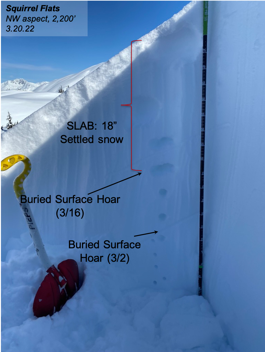
Snow pit from the Placer Valley area at 2,200′. This pit had both layer of buried surface hoar with only the top layer (3/16) failing in stability tests. 3.20.22.
Yesterday: Mostly cloudy skies with light snowfall was over the region. Accumulations were between 1-5″, with the higher amounts falling in Portage Vally and Turnagain, Ridgetop winds were moderate from the east (10-20mph, gusts in the 30’s). Mountain temperatures have been in the 20’sF with sea level warming to the low 30’sF.
Today: Light snowfall through the day should add 2-5″ in most areas. This will transition to heavy snowfall after sunset. Ridgetop easterly winds are expected to climb into the 30-40’s mph by this afternoon with stronger gusts. Temperatures look to stay close to 30F at sea level and in the 20’s in the mountains – bringing mostly snow today at all elevations.
Tomorrow: Storm Day! Heavy snowfall, strong east winds and warming temperatures (bringing the rain/snow line up to around 700′). Up to 2 feet of snow could fall tomorrow at elevations above 1,000′. Ridgetop winds will be easterly near 40mph with stronger gusts.
PRECIPITATION 24-hour data (6am – 6am)
Temp Avg (F) | Snow (in) | Water (in) | Snow Depth (in) | |
---|---|---|---|---|
Center Ridge (1880′) | 27 | 5 | 0.3 | 98 |
Summit Lake (1400′) | 26 | 1 | 0.1 | 39 |
Alyeska Mid (1700′) | 27 | 2.5 | 0.1 | N/A |
RIDGETOP 24-hour data (6am – 6am)
Temp Avg (F) | Wind Dir | Wind Avg (mph) | Wind Gust (mph) | |
---|---|---|---|---|
Sunburst (3812′) | 21 | NE | 16 | 34 |
Seattle Ridge (2400′) | 25 | SE | 5 | 13 |
Date | Region | Location | Observer |
---|---|---|---|
05/22/23 | Turnagain | Avalanche: Tincan | Nick D'Alessio |
05/12/23 | Turnagain | Avalanche: Tincan, Sunburst, Magnum, Cornbiscuit | Heather Thamm |
05/07/23 | Turnagain | Observation: Tincan – Bear Tracks | CNFAIC Staff |
05/05/23 | Turnagain | Observation: Seattle Ridge | AS/ WW Forecaster |
05/02/23 | Turnagain | Observation: Cornbiscuit | Schauer/ Sturgess Forecaster |
05/02/23 | Turnagain | Observation: Seward Hwy Turnagain Pass | Joel Curtis |
04/30/23 | Turnagain | Observation: Magnum | Ayla, Kit Crosby, Barton |
04/29/23 | Turnagain | Observation: Tincan | John Sykes |
04/28/23 | Turnagain | Avalanche: Taylor Pass/Pastoral | Schauer/ Creighton Forecaster |
04/28/23 | Turnagain | Avalanche: Tincan | Andy Moderow |
Status of riding areas across the Chugach NF is managed by the Glacier and Seward Ranger Districts, not avalanche center staff. Riding area information is posted as a public service to our users and updated based on snow depth and snow density to prevent resource damage at trailhead locations. Riding area questions contact: mailroom_r10_chugach@fs.fed.us
Area | Status | Weather & Riding Conditions |
---|---|---|
Glacier District |
Subscribe to Turnagain Pass
Avalanche Forecast by Email
This is a general backcountry avalanche advisory issued for Turnagain Arm with Turnagain Pass as the core advisory area. This advisory does not apply to highways, railroads or operating ski areas.