Turnagain Pass RSS

Archives
ARCHIVED - Forecasts expire after 24 hours.
Issued
Sun, March 20th, 2022 - 7:00AM
Expires
Mon, March 21st, 2022 - 7:00AM
Forecaster
Andrew Schauer
Avalanche risk The Bottom Line

The avalanche danger is MODERATE above 1000′. It is possible a person will trigger an avalanche 1-2′ deep where yesterday’s winds created sensitive slabs with the snow that fell during the second half of the week. In addition to these lingering wind slabs, there are two weak layers of buried surface hoar in the upper 1-3′ of the snowpack that will make larger avalanches possible. The danger is LOW below 1000′, where the primary concern will be wet loose avalanches as southerly aspects heat up during the day.

PORTAGE/PLACER VALLEYS: These areas got upwards of 2′ of snow during this week’s storm, and saw strong winds yesterday. We have limited info from these zones, but we do know there is potential for very large avalanches. Extra caution is warranted in the Portage and Placer valleys today.

Sun, March 20th, 2022
Alpine
Above 2,500'
2 - Moderate
Avalanche risk
Treeline
1,000'-2,500'
2 - Moderate
Avalanche risk
Below Treeline
Below 1,000'
1 - Low
Avalanche risk
0 - No Rating
1 - Low
2 - Moderate
3 - Considerable
4 - High
5 - Extreme
Avalanche risk Avalanche risk Avalanche risk Avalanche risk Avalanche risk
Travel Advice Generally safe avalanche conditions. Watch for unstable snow on isolated terrain features. Heightened avalanche conditions on specific terrain features. Evaluate snow and terrain carefully; identify features of concern. Dangerous avalanche conditions. Careful snowpack evaluation, cautious route-finding, and conservative decision-making essential. Very dangerous avalanche conditions. Travel in avalanche terrain not recommended. Extraordinarily dangerous avalanche conditions. Avoid all avalanche terrain.
Likelihood of Avalanches Natural and human-triggered avalanches unlikely. Natural avalanches unlikely; human-triggered avalanches possible. Natural avalanches possible; human-triggered avalanches likely. Natural avalanches likely; human-triggered avalanches very likely. Natural and human-triggered avalanches certain.
Avalanche Size and Distribution Small avalanches in isolated areas or extreme terrain. Small avalanches in specific areas; or large avalanches in isolated areas. Small avalanches in many areas; or large avalanches in specific areas; or very large avalanches in isolated areas. Large avalanches in many areas; or very large avalanches in specific areas. Very large avalanches in many areas.
Recent Avalanches

There were multiple natural and human-triggered avalanches yesterday in Girdwood and Turnagain Pass. Here is the list of activity:

Goat Mtn.: A large natural avalanche occurred in the Goat Couloir yesterday, propagating across the entire width of the couloir. The avalanche was most likely triggered by cornice fall or possibly by a smaller avalanche coming off of the rocks above the couloir.

Berry Pass: A skier triggered an avalanche 1-2′ deep and about 150′ wide just above Berry Pass. The avalanche failed on the 3/16 surface hoar layer, which was on top of a thin crust. Nobody was caught or carried in the avalanche.

Seattle Ridge: There were avalanches in Main Bowl, Zero Bowl, Warmup Bowl, Pyramid, and the front side of Seattle Ridge yesterday. Most were around  a foot deep and 100-200′ wide. These were failing on the 3/16 interface, and it is possible that the 3/16 surface hoar layer was involved in some of them. Some occurred naturally, some were triggered by snowmachines, and some were triggered by skiers. A snowmachine also triggered a large cornice fall, in which the rider and the machine fell several hundred feet. The rider was uninjured, but the machine was unrideable after the fall.

Tincan: A small natural wind slab released on the lower part of CFR ridge yesterday.

Skier-triggered avalanche on the east face of Pyramid. Nobody was caught or carried in the avalanche. Photo: Henry Munter 03.19.2022.

Natural avalanche in Seattle Ridge’s Warmup Bowl yesterday. Photo Kelly O. 03.19.2022

Natural avalanche in the Goat Couloir yesterday. Photo: Brian Sieknowski. 03.20.2022

Avalanche Problem 1
  • Wind Slabs
    Wind Slabs
  • Certain
    Very Likely
    Likely
    Possible
    Unlikely
    Likelihood
  • Historic (D4-5)
    Very Large (D3)
    Large (D2)
    Small (D1)
    Size
Wind Slabs
Wind Slab avalanches are the release of a cohesive layer of snow (a slab) formed by the wind. Wind typically transports snow from the upwind sides of terrain features and deposits snow on the downwind side. Wind slabs are often smooth and rounded and sometimes sound hollow, and can range from soft to hard. Wind slabs that form over a persistent weak layer (surface hoar, depth hoar, or near-surface facets) may be termed Persistent Slabs or may develop into Persistent Slabs.

Likelihood of Avalanches
Terms such as "unlikely", "likely", and "certain" are used to define the scale, with the chance of triggering or observing avalanches increasing as we move up the scale. For our purposes, "Unlikely" means that few avalanches could be triggered in avalanche terrain and natural avalanches are not expected. "Certain" means that humans will be able to trigger avalanches on many slopes, and natural avalanches are expected.

Size of Avalanches
Avalanche size is defined by the largest potential avalanche, or expected range of sizes related to the problem in question. Assigned size is a qualitative estimate based on the destructive classification system and requires specialists to estimate the harm avalanches may cause to hypothetical objects located in the avalanche track (AAA 2016, CAA 2014). Under this schema, "Small" avalanches are not large enough to bury humans and are relatively harmless unless they carry people over cliffs or through trees or rocks. Moving up the scale, avalanches become "Large" enough to bury, injure, or kill people. "Very Large" avalanches may bury or destroy vehicles or houses, and "Historic" avalanches are massive events capable of altering the landscape.

Signal Word Size (D scale) Simple Descriptor
Small 1 Unlikely to bury a person
Large 2 Can bury a person
Very Large 3 Can destroy a house
Historic 4 & 5 Can destroy part or all of a village
More info at Avalanche.org

Strong winds followed the storm that brought 1-2′ of snow over the second half of the week, and human-triggered avalanches will be possible today despite a quiet day weather-wise. We received reports of multiple natural and human-triggered avalanches yesterday (see the recent activity section above), and similar human-triggered activity is still possible. Some of these avalanches are failing on a layer of buried surface hoar that formed just ahead of the storm (more on that in Problem 2 below), which will make them slower to heal than a typical wind slab problem.

It will be important to approach steep terrain carefully today, taking the time to assess the snowpack where you are travelling. Be on the lookout for signs of unstable snow, such as shooting cracks, collapsing, and fresh avalanches. Use small test slopes to see if the snow is reactive before moving into bigger terrain. If you are trying to get into steep terrain, be sure to only expose one person at a time and watch your partners from safe spots. Don’t get lulled into complacency by the fair weather today, there is still a very real chance someone can trigger an avalanche big enough to bury, injure or kill a person.

Wet Loose: We can expect to see natural and human-triggered wet loose avalanches as the sun heats up southerly aspects today. These are usually not big enough to bury a person, but they do have the potential to trigger larger slab avalanches. Be aware of changing conditions through the day, and think about moving to shaded slopes as things start to heat up.

Cornices: Large cornices exist along ridgelines everywhere now. Yesterday’s incident with a snowmachine triggering a large cornice fall is a scary reminder to keep plenty of space from the edge as you travel along ridgelines. It is also important to limit time spent under cornices, especially as they heat up during the day.

Glide Avalanches: We got a report of the first glide crack releasing in a very long time yesterday in the upper Girdwood valley. There are active glide cracks throughout our advisory area- including in some high-traffic areas like above the Seattle Ridge motorized uptrack. These are unpredictable and very dangerous since they involve the entire season’s snowpack, so be sure to avoid spending time under them.

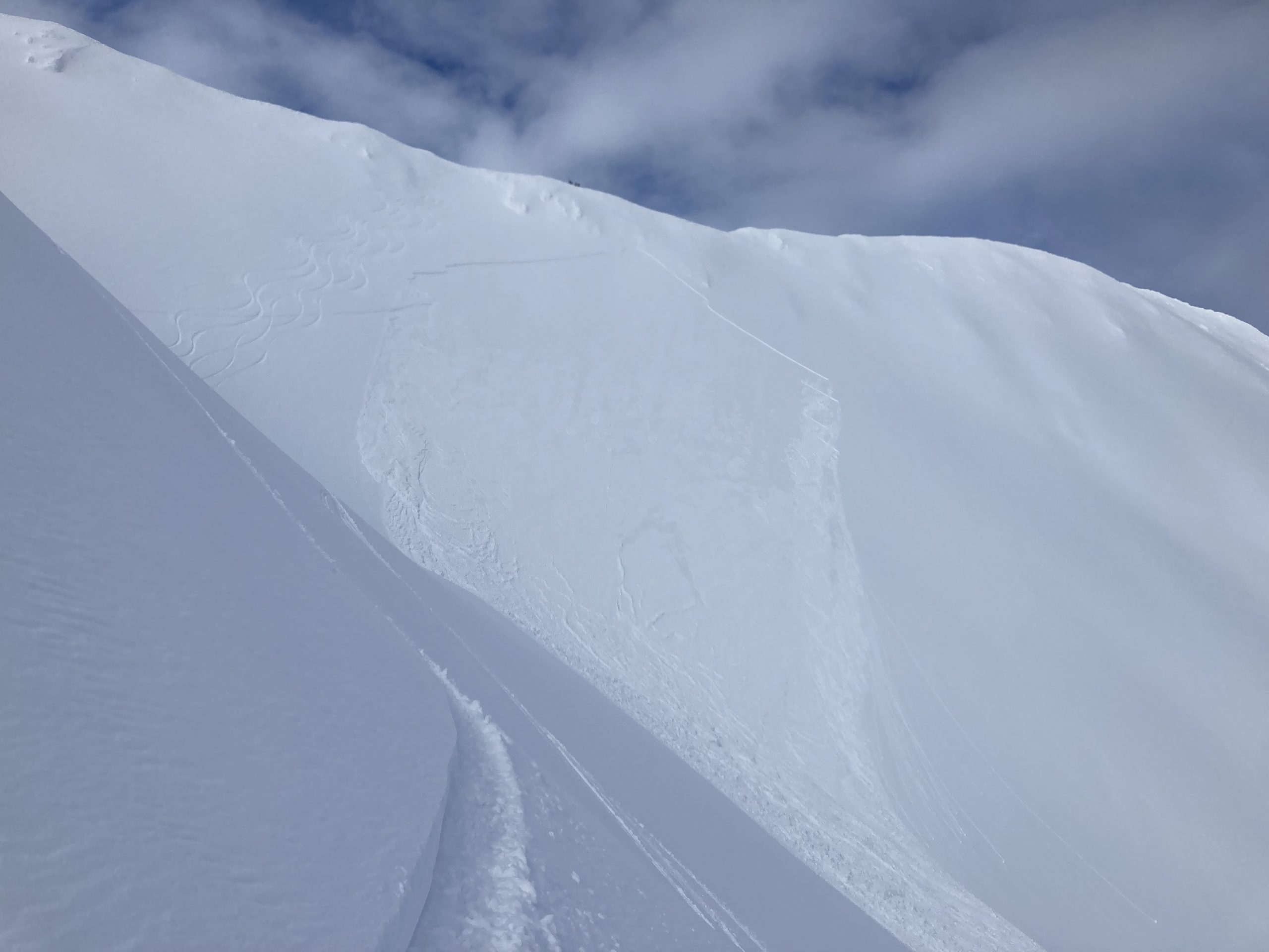
Serious wind loading in Seattle Ridge’s Zero Bowl late yesterday afternoon, with a natural wind slab avalanche in the background. Those wind slabs that formed yesterday will remain reactive today. 03.19.2022

Avalanche Problem 2
  • Persistent Slabs
    Persistent Slabs
  • Certain
    Very Likely
    Likely
    Possible
    Unlikely
    Likelihood
  • Historic (D4-5)
    Very Large (D3)
    Large (D2)
    Small (D1)
    Size
Persistent Slabs
Persistent Slab avalanches are the release of a cohesive layer of snow (a slab) in the middle to upper snowpack, when the bond to an underlying persistent weak layer breaks. Persistent layers include: surface hoar, depth hoar, near-surface facets, or faceted snow. Persistent weak layers can continue to produce avalanches for days, weeks or even months, making them especially dangerous and tricky. As additional snow and wind events build a thicker slab on top of the persistent weak layer, this avalanche problem may develop into a Deep Persistent Slab.

Likelihood of Avalanches
Terms such as "unlikely", "likely", and "certain" are used to define the scale, with the chance of triggering or observing avalanches increasing as we move up the scale. For our purposes, "Unlikely" means that few avalanches could be triggered in avalanche terrain and natural avalanches are not expected. "Certain" means that humans will be able to trigger avalanches on many slopes, and natural avalanches are expected.

Size of Avalanches
Avalanche size is defined by the largest potential avalanche, or expected range of sizes related to the problem in question. Assigned size is a qualitative estimate based on the destructive classification system and requires specialists to estimate the harm avalanches may cause to hypothetical objects located in the avalanche track (AAA 2016, CAA 2014). Under this schema, "Small" avalanches are not large enough to bury humans and are relatively harmless unless they carry people over cliffs or through trees or rocks. Moving up the scale, avalanches become "Large" enough to bury, injure, or kill people. "Very Large" avalanches may bury or destroy vehicles or houses, and "Historic" avalanches are massive events capable of altering the landscape.

Signal Word Size (D scale) Simple Descriptor
Small 1 Unlikely to bury a person
Large 2 Can bury a person
Very Large 3 Can destroy a house
Historic 4 & 5 Can destroy part or all of a village
More info at Avalanche.org

After multiple human-triggered avalanches on buried surface hoar yesterday, persistent slab avalanches remain a concern today. There are two layers of buried surface hoar we are keeping track of right now, one of which is 6-12″ deep and the other is 1-2′ deep. These layers are slowly gaining strength with time, but they are still dangerous for now. As these layers become more stubborn, they won’t always give you clear feedback before triggering an avalanche so the best way to manage a problem like this is through smart terrain management. Avoid big terrain with features that increase the consequences of triggering an avalanche. These are things like cliffs, rocks and trees, or slopes that run down into creeks or gullies. As mentioned above, be sure to only expose one person at a time to steep terrain, and watch your partners from safe spots.

If you want to avoid the problem entirely, simply stick to lower angle terrain. With plenty of snow over the last few days, there is a lot of really good riding and skiing to be had without getting into avalanche terrain. These layers do heal with time, so patience is key when dealing with a persistent slab problem.

Skier-triggered avalanche in the Girdwood area yesterday. The avalanche failed on the 3/16 surface hoar layer, which was on top of a thin crust. The avalanche was 1-2′ deep and about 150′ wide. Photo: Mike Welch 03.19.2022.

Weather
Sun, March 20th, 2022

Yesterday: We were pleasantly surprised with mostly sunny skies for most of the day. Winds were blowing 15-30 mph along the ridgetops, with high temperatures in the mid 20’s all the way up to the low 40’s. Low temperatures dropped down into the 20’s F overnight.

Today: Today is looking like another beauty, with mostly sunny skies and light easterly winds at 5-10 mph. Winds are looking to shift westerly later in the day, but stay below 10 mph. High temperatures should be in the mid 20’s to mid 30’s F, with overnight lows in the upper teens to 20 F.

Tomorrow: Another day of mostly sunny skies is on the way tomorrow. Light northeasterly winds should stay around 5-10 mph, with high temperatures in the upper 20’s to mid 30’s F.  Active weather returns to the area Tuesday afternoon, as another system moves in that could bring another significant round of snow during the middle of the week. Stay tuned for more.

PRECIPITATION 24-hour data (6am – 6am)

Temp Avg (F) Snow (in) Water (in) Snow Depth (in)
Center Ridge (1880′) 34 0 0 95
Summit Lake (1400′) 32 0 0 39
Alyeska Mid (1700′) 34 0 0 N/A

RIDGETOP 24-hour data (6am – 6am)

Temp Avg (F) Wind Dir Wind Avg (mph) Wind Gust (mph)
Sunburst (3812′) N/A N/A N/A N/A
Seattle Ridge (2400′) 25 SE 9 24
Observations
Recent Observations for Turnagain Pass
Date Region Location
04/23/24 Turnagain Observation: Turnagain Sunny Side
04/21/24 Turnagain Observation: Bertha Creek
04/20/24 Turnagain Avalanche: Spokane Creek
04/16/24 Turnagain Observation: Cornbiscuit
04/15/24 Turnagain Observation: Taylor Pass
04/15/24 Turnagain Observation: Seward Highway – Tern Lake to Portage
04/14/24 Turnagain Observation: Sunburst
04/14/24 Turnagain Observation: Turnagain Pass Snomo
04/13/24 Turnagain Observation: Spokane Creek
04/11/24 Turnagain Observation: Tincan
Riding Areas

The riding areas page has moved. Please click here & update your bookmarks.


Subscribe to Turnagain Pass
Avalanche Forecast by Email

This is a general backcountry avalanche advisory issued for Turnagain Arm with Turnagain Pass as the core advisory area. This advisory does not apply to highways, railroads or operating ski areas.