Turnagain Pass
|
|
Good morning backcountry travelers this is Carl Skustad with the Chugach National Forest Avalanche Information Center on Saturday March 13th, 2010 at 7 am. This will serve as a general backcountry avalanche advisory issued for Turnagain Arm with Turnagain Pass as the core advisory area (this advisory does not apply to highways, railroads, or operating ski areas).
WEATHER ROUNDUP
A trace of new snow in the forecast area this morning. Southeast winds remain light at sealevel, with gusts in the 20’s at ridgetops. Temperatures are 8 to 11 degrees F. The radar shows light scattered showers moving in our direction from Prince William Sound. The satellite indicated more partly cloudy skies. The next weather system looks to be moving into the area tomorrow.
AVALANCHE DISCUSSION
Today’s danger level will stay at MODERATE due to lack of significant weather in the past 24-48 hours, time since the last major storm, and no significant weather forecasted for today.
Moderate avalanche danger means heightened avalanche conditions on specific terrain features. Evaluate snow and terrain carefully; identify features of concern. Natural avalanches unlikely; human triggered avalanches possible.
We’ve got some more beta on the human triggered Cornbiscuit avalanche that occurred on Thursday the 11th. It looks like it failed where the snowpack was thin and propagated nearly 500 ft pulling as deep as 6-7 ft. The bed surface and weak layer seem to be the new snow old snow interface that was created one week ago. I think there was enough solar warmth between storms to create a slight crust with facets associated under the crust. This same layer was observed on Sunburst and Sunnyside yesterday. All tests conducted on this layer indicate fair to good stability (CT scores of 23,26,20). The take home is, we have a weak layer and it is difficult to trigger. But, if you do trigger it, it could go big. I would expect to see trigger points for similar avalanche activity on steep south and southwest facing alpine terrain (38 deg. plus) where the snow is thin.
Many big lines were made yesterday on steep terrain and no reported avalanche activity. Make sure you follow your backcountry rituals today. One at a time, watch your partner, carry all your rescue gear and know how to use it, and have an escape route in mind if you travel on large terrain.
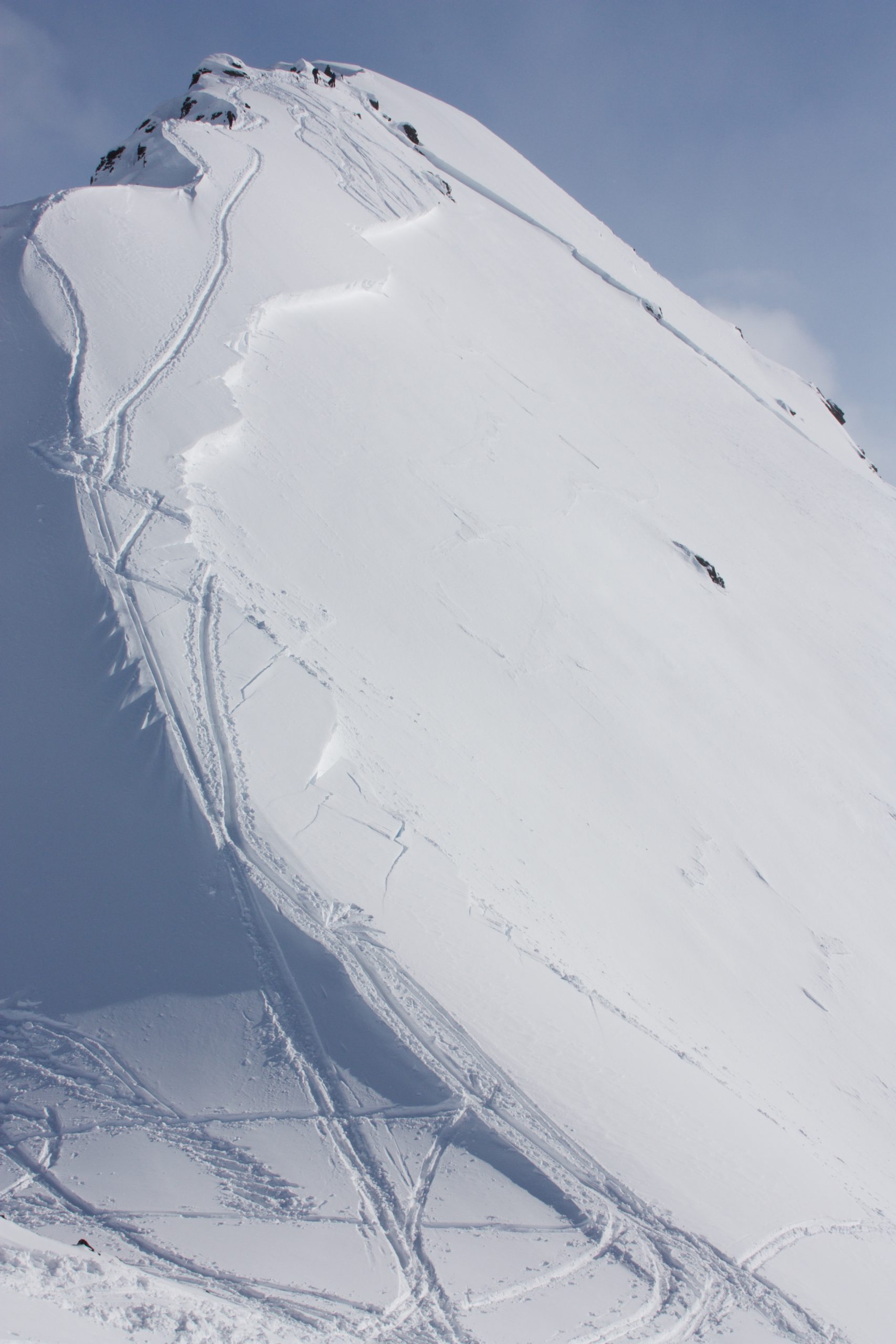

Looking at S face of Cornbiscuit avalanche, photo: Bailly


These photos look down the Cornbiscuit avalanche, the debris goes 100 ft up Lipps. Had someone been caught in this avalanche the consequences would have been large. photo: Bailly
WEATHER FORECAST (National Weather Service)
WESTERN PRINCE WILLIAM SOUND-
INCLUDING…WHITTIER…SEWARD…GIRDWOOD…MOOSE PASS
500 AM AKST SAT MAR 13 2010
.TODAY…MOSTLY CLOUDY WITH SCATTERED SNOW SHOWERS. HIGHS AROUND
30. VARIABLE WIND 10 MPH EXCEPT NORTH 15 TO 30 MPH NEAR SEWARD.
.TONIGHT…A CHANCE OF SNOW IN THE EVENING…THEN SNOW LIKELY
AFTER MIDNIGHT. SNOW ACCUMULATION 2 TO 4 INCHES. LOWS 15 TO 25.
NORTH WIND 10 TO 15 MPH EXCEPT NORTH 25 TO 35 MPH NEAR SEWARD.
.SUNDAY…SNOW…MIXING WIT RAIN IN THE AFTERNOON. SNOW ACCUMULATION
1 TO 5 INCHES. HIGHS IN THE 30S. NORTHEAST WIND 10 TO 15 MPH EXCEPT
NORTH 20 TO 35 MPH NEAR SEWARD.
.SUNDAY NIGHT…SNOW LIKELY. LOWS AROUND 30. VARIABLE WIND 10 MPH
EXCEPT NORTH 15 TO 20 MPH NEAR SEWARD.
.MONDAY…MOSTLY CLOUDY WITH A CHANCE OF SNOW. HIGHS IN THE 30S.
VARIABLE WIND 10 MPH EXCEPT NORTH 10 TO 20 MPH NEAR SEWARD.
.MONDAY NIGHT…MOSTLY CLOUDY WITH A SLIGHT CHANCE OF SNOW. LOWS
25 TO 35.
TEMPERATURE / PRECIPITATION
SEWARD 31 25 38 / 70 90 90
GIRDWOOD 28 21 37 / 30 60 60
WEATHER STATION SUMMARY for last 24 hours at TURNAGAIN PASS
3800′-Sunburst Wx Station
Current Temp: 8 deg F (11 deg warmer than yesterday)
Winds: average east winds are in the upper teens to lower 20’s, gust are in the 20’s
2600′-Seattle Ridge Wx Station
Winds: average SE winds of 7 with gusts to 9
1800′-Center Ridge Wx Station
Current Temp: 14 deg F (14 degrees warmer than yesterday)
Precip: 0, total snowpack 128 after anCNFAIC Staff 3 inches of settlement.
Thanks for checking today’s avalanche advisory. Lisa will post tomorrow morning, Saturday March 14, 2010.
