Turnagain Pass RSS

Archives
ARCHIVED - Forecasts expire after 24 hours.
Issued
Thu, March 2nd, 2023 - 7:00AM
Expires
Fri, March 3rd, 2023 - 7:00AM
Forecaster
Andrew Schauer
Avalanche risk The Bottom Line

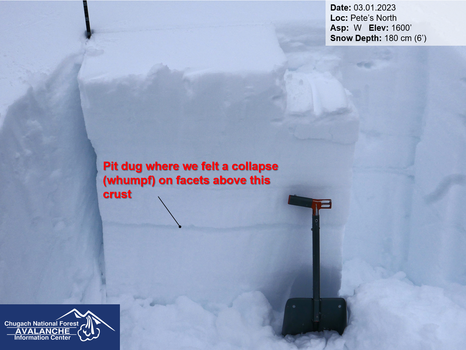
The avalanche danger will remain CONSIDERABLE above 1000′ as northwest outflow winds continue today. It is likely a person will be able to trigger a wind slab avalanche 1-2′ deep where winds are forming sensitive slabs– especially near ridgelines, convexities, and steep gullies. Safe travel will require identifying and avoiding steep wind-loaded features. The danger is MODERATE below 1000′, where it will still be possible to find reactive wind slabs, but they will be a bit more isolated in these lower elevations.

PORTAGE / PLACER VALLEYS: These areas saw over a foot of new snow between Tuesday and Wednesday, and will see some of the highest winds today. This makes very large avalanches possible in these zones.

SUMMIT LAKE: Summit is usually hit hard by the type of winds we are expecting today. This zone also has a thinner, weaker snowpack than the core advisory area. This will be a dangerous combination, and extra caution is warranted in this area.

SNUG HARBOR / LOST LAKE / SEWARD: These southern zones will see the strongest winds today, with sustained speeds around 30-35 mph and gusts over 50 mph likely.

Special Announcements

State of Alaska DOT&PF Avalanche Closure Notification: There will be intermittent traffic delays Thursday March 2, 2023, on the Portage Glacier Highway for Avalanche Hazard Reduction work south of Girdwood near mile post 5 and Bear Valley on the Portage Glacier Highway. Motorists should expect delays of up to 45 minutes between 09:00 AM and 11:00 AM.

Thu, March 2nd, 2023
Alpine
Above 2,500'
3 - Considerable
Avalanche risk
Treeline
1,000'-2,500'
3 - Considerable
Avalanche risk
Below Treeline
Below 1,000'
2 - Moderate
Avalanche risk
0 - No Rating
1 - Low
2 - Moderate
3 - Considerable
4 - High
5 - Extreme
Avalanche risk Avalanche risk Avalanche risk Avalanche risk Avalanche risk
Travel Advice Generally safe avalanche conditions. Watch for unstable snow on isolated terrain features. Heightened avalanche conditions on specific terrain features. Evaluate snow and terrain carefully; identify features of concern. Dangerous avalanche conditions. Careful snowpack evaluation, cautious route-finding, and conservative decision-making essential. Very dangerous avalanche conditions. Travel in avalanche terrain not recommended. Extraordinarily dangerous avalanche conditions. Avoid all avalanche terrain.
Likelihood of Avalanches Natural and human-triggered avalanches unlikely. Natural avalanches unlikely; human-triggered avalanches possible. Natural avalanches possible; human-triggered avalanches likely. Natural avalanches likely; human-triggered avalanches very likely. Natural and human-triggered avalanches certain.
Avalanche Size and Distribution Small avalanches in isolated areas or extreme terrain. Small avalanches in specific areas; or large avalanches in isolated areas. Small avalanches in many areas; or large avalanches in specific areas; or very large avalanches in isolated areas. Large avalanches in many areas; or very large avalanches in specific areas. Very large avalanches in many areas.
Recent Avalanches

There were no new avalanches reported yesterday. The last known activity was a snowboarder-triggered avalanche on the south face of Magnum five days ago.

Avalanche Problem 1
  • Wind Slabs
    Wind Slabs
  • Aspect/Elevation
  • Certain
    Very Likely
    Likely
    Possible
    Unlikely
    Likelihood
  • Historic (D4-5)
    Very Large (D3)
    Large (D2)
    Small (D1)
    Size
Wind Slabs
Wind Slab avalanches are the release of a cohesive layer of snow (a slab) formed by the wind. Wind typically transports snow from the upwind sides of terrain features and deposits snow on the downwind side. Wind slabs are often smooth and rounded and sometimes sound hollow, and can range from soft to hard. Wind slabs that form over a persistent weak layer (surface hoar, depth hoar, or near-surface facets) may be termed Persistent Slabs or may develop into Persistent Slabs.

Aspect/Elevation of the Avalanche Problem
Specialists develop a graphic representation of the potential distribution of a particular avalanche problem across the topography. This aspect/elevation rose is used to indicate where the particular avalanche problem is thought to exist on all elevation aspects. Areas where the avalanche problem is thought to exist are colored grey, and it is less likely to be encountered in areas colored white.

Likelihood of Avalanches
Terms such as "unlikely", "likely", and "certain" are used to define the scale, with the chance of triggering or observing avalanches increasing as we move up the scale. For our purposes, "Unlikely" means that few avalanches could be triggered in avalanche terrain and natural avalanches are not expected. "Certain" means that humans will be able to trigger avalanches on many slopes, and natural avalanches are expected.

Size of Avalanches
Avalanche size is defined by the largest potential avalanche, or expected range of sizes related to the problem in question. Assigned size is a qualitative estimate based on the destructive classification system and requires specialists to estimate the harm avalanches may cause to hypothetical objects located in the avalanche track (AAA 2016, CAA 2014). Under this schema, "Small" avalanches are not large enough to bury humans and are relatively harmless unless they carry people over cliffs or through trees or rocks. Moving up the scale, avalanches become "Large" enough to bury, injure, or kill people. "Very Large" avalanches may bury or destroy vehicles or houses, and "Historic" avalanches are massive events capable of altering the landscape.

Signal Word Size (D scale) Simple Descriptor
Small 1 Unlikely to bury a person
Large 2 Can bury a person
Very Large 3 Can destroy a house
Historic 4 & 5 Can destroy part or all of a village
More info at Avalanche.org

As northwest winds continue today, our main concern will be triggering a wind slab avalanche up to 1-2′ deep. The wind has been at work building sensitive slabs out of Tuesday’s low-density storm snow, and we should expect to find reactive slabs in wind-loaded terrain through today. The most likely places to find unstable snow will be near ridgelines, convexities, and in steep gullies.

This wind pattern is coming out of the opposite direction from our more common easterly winds, which means it will be loading terrain differently than ‘normal’. This makes it a little harder to anticipate where you might find reactive wind slabs, and we need to be careful about committing to steep terrain. Avoid slopes with stiff or punchy snow on the surface, and pay attention to warning signs like cracks shooting out from your snowmachine or skis as you travel today. The most stable snow should be found at lower elevations in terrain that is protected from the wind.

You can click here to view the video below if it doesn’t load in your browser.

Avalanche Problem 2
  • Persistent Slabs
    Persistent Slabs
  • Aspect/Elevation
  • Certain
    Very Likely
    Likely
    Possible
    Unlikely
    Likelihood
  • Historic (D4-5)
    Very Large (D3)
    Large (D2)
    Small (D1)
    Size
Persistent Slabs
Persistent Slab avalanches are the release of a cohesive layer of snow (a slab) in the middle to upper snowpack, when the bond to an underlying persistent weak layer breaks. Persistent layers include: surface hoar, depth hoar, near-surface facets, or faceted snow. Persistent weak layers can continue to produce avalanches for days, weeks or even months, making them especially dangerous and tricky. As additional snow and wind events build a thicker slab on top of the persistent weak layer, this avalanche problem may develop into a Deep Persistent Slab.

Aspect/Elevation of the Avalanche Problem
Specialists develop a graphic representation of the potential distribution of a particular avalanche problem across the topography. This aspect/elevation rose is used to indicate where the particular avalanche problem is thought to exist on all elevation aspects. Areas where the avalanche problem is thought to exist are colored grey, and it is less likely to be encountered in areas colored white.

Likelihood of Avalanches
Terms such as "unlikely", "likely", and "certain" are used to define the scale, with the chance of triggering or observing avalanches increasing as we move up the scale. For our purposes, "Unlikely" means that few avalanches could be triggered in avalanche terrain and natural avalanches are not expected. "Certain" means that humans will be able to trigger avalanches on many slopes, and natural avalanches are expected.

Size of Avalanches
Avalanche size is defined by the largest potential avalanche, or expected range of sizes related to the problem in question. Assigned size is a qualitative estimate based on the destructive classification system and requires specialists to estimate the harm avalanches may cause to hypothetical objects located in the avalanche track (AAA 2016, CAA 2014). Under this schema, "Small" avalanches are not large enough to bury humans and are relatively harmless unless they carry people over cliffs or through trees or rocks. Moving up the scale, avalanches become "Large" enough to bury, injure, or kill people. "Very Large" avalanches may bury or destroy vehicles or houses, and "Historic" avalanches are massive events capable of altering the landscape.

Signal Word Size (D scale) Simple Descriptor
Small 1 Unlikely to bury a person
Large 2 Can bury a person
Very Large 3 Can destroy a house
Historic 4 & 5 Can destroy part or all of a village
More info at Avalanche.org

We are still seeing indications that the weak layers buried in the upper 2-3′ of the snowpack are capable of producing avalanches on isolated slopes in our area. Yesterday we experienced a collapse that failed on a layer of facets above a crust buried about 2′ deep on Pete’s North, which is a clear warning sign (more details here). These signs of unstable snow are becoming harder and harder to find, but that was a clear indicator that we can’t forget about those weak layers just yet. The most concerning areas are the places with a thinner overall snowpack– towards the south end of Turnagain Pass and down into Summit. These layers are really tricky to assess, and because they are giving us inconsistent feedback the only way to truly manage the problem is to avoid big, steep terrain where we know the snowpack is thinner and weaker.

We stopped and dug a pit right where we felt the collapse, and got an unstable test result on a layer of facets above a crust about 2′ deep. 03.01.2023

Weather
Thu, March 2nd, 2023

Yesterday: Skies were mostly cloudy with light flurries and some low level clouds moving in and out through the day. Winds were blowing 10-20 mph out of the west to northwest with gusts of 30-35 mph, with the highest wind speeds getting recorded over the past few hours. High temperatures were in the low teens F at upper elevations and mid 20’s F in the valleys.

Today: Northwest outflow winds are expected to continue today, blowing 10-25 mph with gusts of 30-40 mph. Speeds will likely be higher along the Turnagain Arm, near Portage, Summit, and Seward. Skies will be mostly cloudy this morning, with decreasing cloud cover through the day. Temperatures should be in the mid to upper teens F today, dropping to the single digits below 0 F tonight. No precipitation is expected.

Tomorrow: Outflow winds are expected to persist tomorrow, with sustained speeds staying around 20-25 mph and gusts of 30-40 mph. Skies should be partly cloudy with high temperatures struggling to get above single digits F. No precipitation is expected tomorrow.

PRECIPITATION 24-hour data (6am – 6am)

Temp Avg (F) Snow (in) Water (in) Snow Depth (in)
Center Ridge (1880′) 22 0 0 70
Summit Lake (1400′) 19 0 0 41
Alyeska Mid (1700′) 19 0 0 72
Bear Valley – Portage (132′) 24 tr 0.09

RIDGETOP 24-hour data (6am – 6am)

Temp Avg (F) Wind Dir Wind Avg (mph) Wind Gust (mph)
Sunburst (3812′) 10 NW 8 35
Seattle Ridge (2400′) 15 NW 11 22
Observations
Recent Observations for Turnagain Pass
Date Region Location
04/23/24 Turnagain Observation: Turnagain Sunny Side
04/21/24 Turnagain Observation: Bertha Creek
04/20/24 Turnagain Avalanche: Spokane Creek
04/16/24 Turnagain Observation: Cornbiscuit
04/15/24 Turnagain Observation: Taylor Pass
04/15/24 Turnagain Observation: Seward Highway – Tern Lake to Portage
04/14/24 Turnagain Observation: Sunburst
04/14/24 Turnagain Observation: Turnagain Pass Snomo
04/13/24 Turnagain Observation: Spokane Creek
04/11/24 Turnagain Observation: Tincan
Riding Areas

The riding areas page has moved. Please click here & update your bookmarks.


Subscribe to Turnagain Pass
Avalanche Forecast by Email

This is a general backcountry avalanche advisory issued for Turnagain Arm with Turnagain Pass as the core advisory area. This advisory does not apply to highways, railroads or operating ski areas.